Classifying remote sensing imageries to obtain reliable and accurate Land Use/Cover (LUC) information still remains a challenge that depends on many factors such as complexity of landscape especially in arid region. The aim of this paper is to extract reliable LUC information from Land sat imageries of the Pishkouh watershed of central arid region, Iran. […]
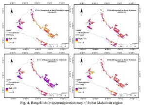
Rangelands are the most important plant ecosystems in Iran that have multiple and vital roles in economic stability and food security in the country. In recent decades, with increasing population, increasing forage consumption, climate change and rainfall fluctuations, most of the country’s pastures have been destroyed or faced with a degradation trend. Therefore, in order […]