Desertification is one of the major issues threatening human communities. Many methods have been developed for assessment and mapping of desertification hazards. In this research, multi-criteria evaluation method was used to investigate desertification process in Trouti watershed, Golestan Province, Iran. At the first step, major desertification factors were determined by doing field surveys. They were […]
Flood disaster is considered as a major natural hazard due to its devastating effects on the affected areas. Determining the flood vulnerable areas is important for decision makers in order to perform planning and management activities. Geographical Information System (GIS) is integrated with Multi Criteria Decision Analysis (MCDA) used to analyze the flood vulnerable areas. […]
Zagros Mountains in west of Iran are covered by unique forests and rangelands. Increasing population, low level of development and high dependence of local people on natural resources for primary livelihood needs resulted in degradation of Zagros forests and rangelands. Along with these factors, since the last decade, climate change including severe drought is an […]
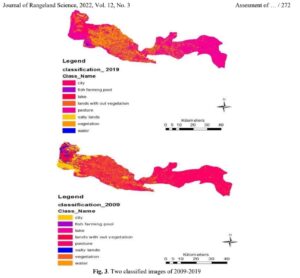
Ecological capability assessment of a land as one of the most important steps in line with sustainable development was conducted based on identifying and pre-designed criteria, following assessment of the land’s assets and its latent power. In the present study, which was conducted in 2019, in order to reveal the changes in the region during […]