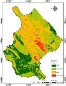
Quantifying fire hazards in natural areas and their spatial patterns are essential for developing appropriate fire management strategies, especially in countries with limited historical data on past fires. In this study, a fire hazard map for the Andika region of Iran was constructed by examining the correlation of past fires with the criteria of topography, […]
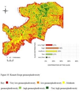
The emerging broad science of geodiversity defined in terms of geomorphological diversity assesses geomorphological features of territory by comparing them in an extrinsic and intrinsic way. This paper uses SRTM (Shuttle Radar Topographic Mission) data and GIS (Geographical Information System) techniques to assess the geomorphological diversity of Komati Gorge, in Mpumalanga Province of South Africa. […]
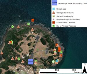
Geoconservation outcomes are hindered by highly subjective and conflicting criteria, varying assessment objectives, disparities in geoconservation strategy steps and the inadequate capturing and representation of geological data in dynamically changing inventories. Review shows that geoconservation outcomes are further hindered by the exclusion of quantitative geodiversity assessment from geoconservation strategies. A geoconservation toolkit is presented using […]