Introduction
Volcanic eruptions and volcanoes attract people leading to a progressively developing segment of geotourism for the last decades (Erfurt-Cooper 2011, 2014; Erfurt-Cooper et al. 2015; Erfurt 2022). Although most visitors look for adventures in active volcanoes, there has been increasing interest also in dormant and inactive volcanic areas, which potentially offer deep insight into why and how volcanoes work and this can lead to discovery also of the cultural and historical heritage of the area. Geoparks with their holistic concept of protection, education and sustainable development play a significant role in revealing volcanic geodiversity and promoting geoeducation and geotourism (Németh 2022). In Europe, volcanic geoheritage has contributed strongly to the development of geoparks since the beginning, when four geoparks, including the Vulkaneifel (Bitschene & Schüller 2011; Bitschene 2015) established the European Geopark Network in 2000 (Zouros 2004). Presently, there are 15 geoparks in Europe where volcanic features are the main focus, covering active, dormant and extinct volcanic fields (Nunes 2022). In eastern-central Europe, these include the Bohemian Paradise Geopark (Petronis et al. 2015; Rapprich et al. 2019), the Novohrad–Nógrád Geopark (Szarvas 2007; Kordos et al. 2021), the Bakony–Balaton Geopark (Pál & Albert 2023; Harangi and Korbély 2023) and the Papuk Geopark (Balen et al. 2023), which involve a rich volcanic history through the last 100 Myr. Volcanic eruptions pose an increasing hazard and risk in the 21th century threatening about 10% of the total population of Earth (Chester et al. 2000; Small & Naumann 2001; Sparks et al. 2013). Geoparks can play a significant role in raising awareness of volcanism via geoeducation on volcanic heritage. Furthermore, they provide a good opportunity to strengthen cooperation and possibly establish a cross-continent volcano route in Europe (Harangi 2014). The Novohrad–Nógrád Geopark is the first example that involves territories of two countries and provides a good example of the joint efforts of people from Hungary and Slovakia.
The Carpathian-Pannonian Region in Eastern-Central Europe offers an ideal, albeit less known destination for volcano tourism (Harangi 2014; Szepesi et al. 2017), since a very wide volcanic activity occurred here in the past 20 million years (Lexa & Konečny 1998; Harangi 2001; Seghedi et al. 2004; Harangi & Lenkey 2007; Lexa et al. 2010; Seghedi & Downes 2011). In this area, almost all volcanological phenomena can be observed, fed by various magmas, from basaltic through andesitic and dacitic to rhyolitic ones. The rich volcanic heritage in addition to the wide geodiversity served as a strong base to establish two geoparks in Hungary. The Novohrad–Nógrád area became a member of the Global Geoparks Network (GGN) as the first transnational geopark in 2010, and then the Bakony–Balaton Uplands joined the GGN after a successful application in 2013. Later, as GGN members they got the title of UNESCO Global Geopark in 2015 and 2016. In this paper, we introduce the Novohrad–Nógrád UNESCO Global Geopark (NNUGGp) where volcanic heritage meets cultural and historical heritage as well as the long living tradition of the Palóc ethnic group. A summary of the Neogene to Quaternary volcanic activity is followed by the presentation of the main, world-class volcanological features of the NNUGGp, while the last section presents the geoeducational and geotouristic efforts and the future perspectives.
Wide Range of Volcanic Geoheritage in the NNUGGp
The geological past of the NNUGGp area was harsh and strongly related to the formation and evolution of the Carpathian–Pannonian Region (CPR). The CPR is a natural laboratory of the close interaction of retreating subduction, lithospheric extension, a wide range of volcanic activity followed by continental collision, post-collisional evolution and neotectonic inversion (e.g., Csontos et al. 1992; Szabó et al. 1992; Lexa, & Konečny 1998; Fodor et al. 1999; Tari et al. 1999; Harangi 2001; Konečny et al. 2002; Seghedi et al. 2004; Horváth et al. 2006, 2015; Harangi and Lenkey 2007; Seghedi and Downes 2011). The volcanism from 19 Ma up to the recent time (Pécskay et al. 2006; Lexa et al. 2010; Lukács et al. 2018) was fed by various magmas from basalts to rhyolites and as a result, various types of volcanic landforms were developed. The area of the NNUGGp is unique in the sense that almost all types of volcanic products can be found here. The initial volcanic phase from 18.2 Ma to 14.4 Ma comprised explosive eruptions of silicic magmas, which resulted in extended ignimbrite sheets and heavy ash fall over several hundreds of kilometers (Lukács et al. 2018, 2021, 2022; Karátson et al. 2022; Brlek et al. 2023). Lukács et al. (2018) suggested that these volcanic eruptions were among the largest in Europe for the last 20 million years. Although most of the volcanic formations are covered by younger sediments through postvolcanic subsidence, they have many outcrops in the northern part of the Pannonian Basin including the area of the NNUGGp. Following and partly overlapping this continental silicic volcanism, andesitic to dacitic volcanic activity built up volcanic complexes (Lexa & Konečny 1974; 1998; Harangi et al. 2001, 2007; Harangi 2001; Seghedi et al. 2004; Harangi & Lenkey 2007; Seghedi & Downes 2011) from ca. 16 Ma up to present (last eruption occurred at Ciomadul, in Romania at 30 ka; Harangi et al. 2010; 2015a; 2020). Within the NNUGGp, such volcanism resulted in a volcanic field of lava domes and small-volume stratovolcanoes between the Börzsöny and Mátra volcanic complexes. This was followed by alkaline basalt volcanism, which formed several monogenetic volcanic fields (Embey-Isztin et al. 1993; Harangi et al. 2015b). One of them is called as Nógrád–Gemer Volcanic Field (Szabó et al. 1992; Szabó & Taylor 1994; Konečny et al. 1995a;1995b; Dobosi et al. 1995) located in the NNUGGp. Volcanism lasted over a prolonged period, from 8–0.4 Ma (Pécskay et al. 2006). Due to the regional post-volcanic uplift of the area of the NNUGGp, both the andesitic and the alkali basaltic volcanoes have been thoroughly eroded and often, only their root-zones, i.e., necks and dykes are presently exposed. However, this serves as a special opportunity to understand what is beneath the volcanoes, and therefore, the NNUGGp offers a particular volcanic geoheritage.
Establishment of the NNUGGp and the Protection of its Geological Heritage
The Novohrad–Nógrád UNESCO Global Geopark (NNUGGp; Fig. 1) comprises 1.619 km2 of territory with 92 settlements and it is a cross-border geopark between Slovakia and Hungary, an important center of the Palóc ethnic group’s folk art and living traditions. Being a transnational geopark, its name comes from the Slovak and Hungarian names of the Counties, where the geopark is located. The natural heritage of the geopark, through legislative means, is state protected in both countries, the geosites are within protected landscape areas, nature reserves, or natural monuments, and it has several international assets such as WHS, EDPA and NATURA 2000 areas.
Geological heritage of this territory has a long protection history dating back to the first half of the 20th century. Some of the protected sites even acquired infrastructure, conservation buildings and visitor facilities, such as the Ipolytarnóc Fossils Nature Reserve, where interpretative guided tours have been running along its geological trail (Lower-Miocene stratotype section) since 1986. The idea of networking, linking together by joint geotourism of such isolated, showable Slovak and Hungarian geosite offers dates back to the 1990s. This project was formulated by the experts of the Hungarian (Bükk National Park Directorate) and Slovak (Cerova Vrchovina CHKO; Chránená krajinná oblast, i.e., protected landscape area) governmental nature conservation organizations with the endorsement of local municipalities on both sides of the border. Practical work on the establishment of the transnational geopark officially started in 2005. The geopark project as a grassroots movement, got inspiration from enthusiastic locals, NGOs and governmental organizations as well as geologists of both countries, building on the rich geological heritage of the area. The Geopark achieved GGN membership in 2010.
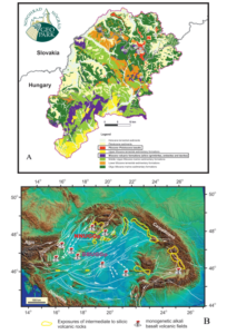
Figure 1. A) Geological diversity of the area of the Novohrad–Nógrád UNESCO Global Geopark. Localities of key volcanic natural values mentioned in the text are indicated by numbers: 1. Fiľakovo/Fülek, 2. Šurice/Sőreg, 3. Hajnáčka/Ajnácskő, 4. Dunivá Hora, 5. Medvedia/Medves, 6. Ragáč/Ragács, 7. Tachty/Tajti, 8. Ipolytarnóc, 9. Páris valley, 10. Karancs, 11. Šomoška/Somoskő, 12. Eresztvény, 13. Salgóbánya, 14. Salgó, Szilváskő, 15. Kazár, 16. Tar, 17. Vadászgödör, 18. Sámsonháza, 19. Bér, 20. Szanda, 21. Hollókő.B) Exposures of the Neogene to Quaternary volcanic rocks in the Carpathian-Pannonian Region and the location of the Novohrad–Nógrád UNESCO Global Geopark (NNUGGp) and the Bakony–Balaton UNESCO Global Geopark (BBUGGp). Monogenetic basalt volcanic fields: 1. Burgenland; 2. Styrian basin; 3. Little Hungarian Plain (Kemenesalja); 4. Bakony–Balaton Uplands; 5. Stiavnica; 6. Nógrád–Gemer; 7. Kecel and the surroundings (buried); 8. Lucaret; 9. Perşani. Source of the topographic map: Horváth et al. (2006); tectonic lineaments: Horváth et al. (2015)
The motto of the geopark is “Ancient world without borders”, which reflects both the remarkable geodiversity (Fig. 1) and the strong link between people living on either side of the official, but now luckily free, state border. The NNUGGp has a rich volcanic geoheritage (Jugovics 1940a; Konečný et al. 1995a; 1999; Lexa et al. 2010; Póka et al. 2004; Szarvas 2007; Harangi 2014; Lukács et al. 2021, 2022; Karátson et al. 2022): almost all types of volcanic products relating to the eruption of basaltic magmas can be observed here in addition to nuée ardentes-related block and ash flow deposits, lava flows and cryptodome body of andesitic volcanic complexes as well as ignimbrites formed by destructive pumiceous pyroclastic flows during catastrophic eruptions of silicic magmas. In fact, almost two-thirds of the presentable geosites of the NNUGGp expose volcanic rocks and therefore, there is a great opportunity here to discover how volcanoes work. The volcanic heritage meets here with cultural and historical heritage (Fig. 2), which makes this area a particularly attractive touristic destination. The constructive and destructive geological processes resulted in varied morphology. Due to this, a settlement-pattern of small villages of the Palóc ethnic group, nestling in isolated valleys was formed. Each settlement created its folk costumes, embroidered with rich motifs and kept its traditions for centuries. Thus, it is not surprising that the ancient village of Hollókő (Fig. 1), located in the core of the NNUGGp, was the first place in Hungary to be recognized as a part of the World Heritage in 1987. The border fortress system which was built onto the volcanic conduits in the middle-ages is the main characteristic of the landscape, but cave-dwellings and churches hollowed out in the sedimentary rocks or the memories of mining are additional interesting examples of the coexistence of humans with the environment.
The emblem of the Geopark depicts the Šomoška/Somoskő Castle (Figs. 1 & 2). The very foot of the medieval castle marked the border line between Slovakia and Hungary after the First World War, separating communities from each other and artificially the landscape for 85 years. The castle stands on a strongly eroded basaltic volcano and a neck that represents beautifully the human interaction with the geological past.
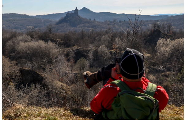
Figure 2. The Novohrad-Nógrád UNESCO Global Geopark where geological, cultural and historical heritages meet. The Šomoška/Somoskő Castle in the front and the Salgó castle in the background were built on basaltic necks.Caption
Volcanological Features in the NNUGGp
Devastation by a Large Volcanic Eruption, Conservation of Unique Footprints
Formation of the Pannonian Basin by major lithospheric extension was accompanied by repeated explosive eruptions of large-volume silicic magmas from 18.2 Ma to 14.4 Ma (Harangi & Lenkey 2007; Lukács et al. 2018,2021; Harangi & Lukács 2019; Karátson et al. 2022). These eruptions resulted in pumiceous pyroclastic flows reaching several tens of kilometers from the source (Brlek et al. 2023) and volcanic ash falls occurred over hundreds of kilometers (Lukács et al. 2018; Rocholl et al. 2018; Šegvić et al. 2023; Bercea et al. 2023) implying significant impact on the Miocene environment and wildlife. This is excellently demonstrated by the Ipolytarnóc Fossils Nature Conservation Areas (IFNCA) in Northern Hungary close to the state border with Slovakia (Figs. 1 and 3). Here, abundant and well-preserved fossil vertebrate footprints as well as remnants of the former tropical forest can be found, and they were recognized as early as 1836 (Bartkó 1985; Hably 1985; Kordos 1985; Szarvas 2007; Kordos et al. 2021). The footprints occur in a sandstone covered by ca. 50-m-thick volcanic deposit (Figs. 3). Zircon U/Pb dating (Pálfy et al. 2007; Lukács et al. 2021; Brlek et al. 2023) showed that this devastating volcanic eruption took place 17.3 Ma and was related to the Eger eruption defined by Lukács et al. (2018) as one of the major eruption events in the Bükkalja volcanic field, about 75 km southeast from Ipolytarnóc. Trace element contents of zircon confirm that the volcanic deposits at Ipolytarnóc derived from the Eger eruption (Lukács et al. 2021). This eruption age is confirmed also by Ar-Ar dates on plagioclase (Pálfy et al. 2007; Šarinová et al. 2021; Karátson et al. 2022).
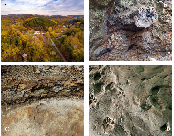
Figure 3. A) The gateway of the Novohrad-Nógrád UNESCO Global Geopark is the Ipolytarnóc Fossils Nature Reserve, where the Visitor Centre offers a modern 4D movie that transports the visitor into the geological past when destructive volcanic eruption destroyed the environment, but preserved uniquely tracks of animals. B and C) Pyroclastic flow deposit containing petrified tree trunk and carbonized plant fragments just above the footprint-bearing sandstone layer. D) Vertebrate footprints in sandstone preserved by the overlying rhyolitic pyroclastic flow deposit.
The 17.3 Ma Eger eruption was one of the largest events in the series of caldera-forming volcanic activities of the Pannonian Basin. Karátson et al. (2022) suggested that ca. 58 km3 of rhyolitic magma erupted and this resulted in more than 100 km3 tephra. Brlek et al. (2023) found a volcanic deposit of the same age and the same geochemical signature in Croatia, and Bercea et al. (2023) proved its existence in Romania, suggesting that this eruption was even bigger. The volcanic succession is well exposed in the Borókás ravine geological study trail. Detailed reconstruction of this eruption was given by Karátson et al. (2022). Accordingly, phreatomagmatic eruptions occurred initially associated with highly energetic pyroclastic surges and flows (Fig. 3C). They run across the terrestrial-intertidal area and buried the forested river bank at the present Ipolytarnóc. Karátson et al. (2022) interpreted them as low-temperature dilute pyroclastic density currents, which therefore preserved the coastal habitat, including the fossil tracks by burying them with thin tephra. No animal bones were found, indicating that animals could have escaped successfully in time before the cataclysmic volcanic eruption. Heavy ash fall accompanied the initial pyroclastic surge and as a result, altogether, 10-15 cm of tephra buried the whole area. However, this was still not the end of the volcanic event. The eruption turned into a more sustained explosive eruption with a high eruption column and hot pumiceous pyroclastic flows. The latter left several tens of meters of lapilli tuff bed with abundant charcoal fragments (Fig. 3B). The rapid deposition of thick volcanic material conserved the watering place, and not long before, thousands of animals visited and left their footprints in the soft sandy deposit. This is a particularly rare situation worldwide and therefore, the Ipolytarnóc site has a great natural value. The emerging scientific results (e.g., Hably 1985; Kordos 1995; Kordos et al. 2021; Šarinová et al. 2021; Karátson et al. 2022) about the pre-volcanic paleobotanical and paleoenvironmental conditions as well as on the volcanic events increase the significance of this site further. A detailed summary of the discovery history as well as the paleontological aspects of this locality was given by Szarvas (2007) and Kordos et al. (2021).
The exceptional geoheritage of Ipolytarnóc led to national protection in 1944 and then it became part of the Bükk National Park. A geological study trail was first established in 1986, where visitors can have regular guided tours. The study trail has been continuously modernized and includes new stops as excavations reveal interesting pieces from the past. The geological history hidden in the Borókás creek succession involves also the shallow marine environment before the volcanism. The abundance of shark’s teeth, which captured the imagination of the local people (there are many legends about the origin of these particular fossils such as these remnants are ‘petrified bird tongues’) implies a rich marine life, while in the terrestrial land thick tropical rainforests existed. Palms, magnolias and laurels accompanied by huge, outstanding pines characterized the multilevel flora (Hably 1985). Towards the end of the 1700s, a large petrified tree was excavated from the volcanic rubble by the Borókás stream. The soft volcanic material from under it was washed away and a 42 m long piece of tree trunk slowly began to span the gully forming a natural stone bridge. The locals recognized the origin of the tree and they liked to sit on it, thus, named it "Gyurtyánkő Lócza" (‘lócza’ means bench in the local language, whereas ‘gyurtyán’ refers to the magic legends saying that this is a charmed tree). This giant pine in the Borókás creek as a natural stone bridge was an organic part of the landscape for a century, although Ferenc Kubinyi, a famous paleontologist found it already collapsed in 1836. It was he who recognized the scientific importance of the tree trunk and described its origin. The huge silicified tree (Pinuxylon tarnocziense) was a real giant of its age, topping 90 m when it lived and had a circumference of 8 m at the time it was found; it is the biggest petrified member of the pine family. A piece of this tree can be seen in a small exhibition room (Fig. 4A) built right on the site where it was originally found. Baktai et al. (1964) published the results of a tree ring study on one of the 17.3 Ma large pine tree remnants (Fig. 4B) and found that growth was consistent with 6–7 years sunspot cycle, shorter than the present one with the 11-years long cycle. The pyroclastic flow destroyed the forested area and many remnants of trees (albeit silicified or charred) were incorporated and preserved in the pumiceous deposit.
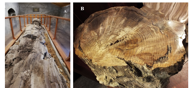
Figure 4. A) The remnant of the once huge (see the circle in the background on the wall illustrating the size of the tree when discovered at the end of the 1700s) pine tree (Pinuxylon tarnocziense) shown in an exhibition room built right on the site where the 42 m long tree was found. B) Tree rings tell 6-7 years of sunspot cycle in the early Miocene, which is shorter than nowadays (11 years).
Ignimbrites and Ignimbrite Badland
In addition to the peculiar Ipolytarnóc site, there are many additional geosites in the NNUGGp, where outcrops expose various features of early to mid-Miocene catastrophic volcanism. There are many locations, where the ignimbrites related to the 17.3 Ma Eger and the 17.1 Ma Mangó eruptions (Lukács et al. 2018) can be found. One of them, north of the village Kazár (Fig. 1), is unique in showing a spectacular badland-type erosional surface (Fig. 5). This is a geomorphological term for landscapes where steep slopes and high erosion rates prevent soil formation and vegetation cover, and so are inappropriate for any kind of agricultural use. The uncovered massive pumiceous pyroclastic flow deposit at Kazár is dissected by several deep gullies, vertical cliffs and barren patches of rocks with the emergence of candle-like columns and earth pyramide (Pintér et al. 2015; Fig. 5). Piping is common, where the surface streams disappear within the pyroclastic material as resurgent streams and form horizontal and vertical tunnels under the crust. The formation of this small-sized badland is due to many factors, such as landslides, forest-fire, exploiting and exhaustive grazing occurred just only in the last centuries (Karátson 2006).
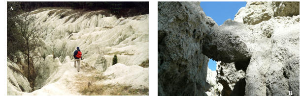
Figure 5. Erosional landform of the 17.1 Ma silicic ignimbrite at Kazár: A) Typical badland landscape; B) Deep erosional gully within the ignimbrite.
Most outcrops of silicic pyroclastic rocks in the NNUGGp area belong to another large eruption event that occurred 14.9 Ma, the Tar ignimbrite eruption (Lukács et al. 2015, 2018, 2021; 2022). The best exposure of the associated volcanic products is found at the northwestern margin of the andesitic volcanic complex of Mátra (Fig. 1). The abandoned Fehérkő Quarry, east of the village Tar provides the name of this volcanic unit (Zelenka et al. 2004; Lukács et al. 2022). The long quarrying revealed a thick (ca. 30 m) volcanic succession, which involves several pumiceous pyroclastic flow units and remarkably well preserved gas-segregation channels (Fig. 6). A petrified moment from the past can be observed here similar, such as occurred in the Valley of Ten Thousand Smokes in 1912 during the largest eruption of the 20th century (Hildreth & Fierstein 2012). This rock has excellent physical properties, such as good heat- and sound-insulation and therefore it was used as a light building stone. Quarrying proceded by cutting large surfaces in the porous material and then these blocks were further cut into brick-shaped pieces. This is the reason for the extended flat walls of the Fehérkő Quarry (Fig. 6A) that offer an insight into the nature of the most devastating volcanic eruption product and makes this place a peculiar volcanic geoheritage of the NNUGGp.
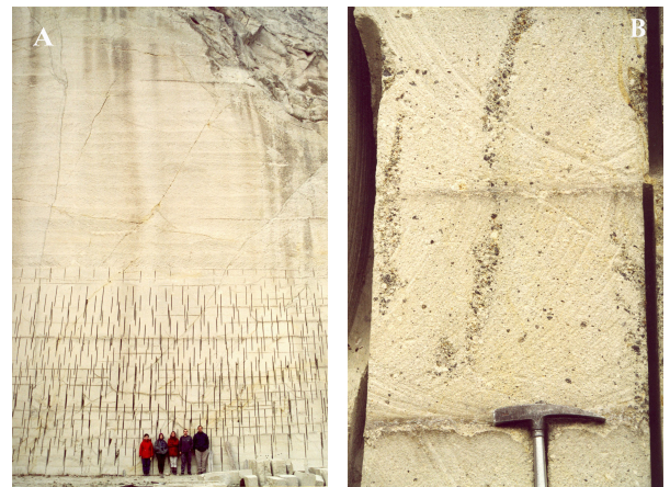
Figure 6. A) Type-locality of the 14.9 Ma old Tar ignimbrite in the Fehérkő-quarry, the product of one of the largest explosive volcanic eruptions in the Pannonian Basin. The light, porous ignimbrite was cut during quarrying. B) Well-preserved gas segregation pipes, where gases escaped upwards transporting the fine material and leaving the coarser grained lapilli in the volcaniclastic deposit
Although mostly the vast amount of ignimbrites, i.e., the product of pumiceous pyroclastic flows, remained exposed on the surface from the early- to mid-Miocene silicic volcanism of the Pannonian Basin, they were associated with volcanic ash falls. However, such deposits are rarely preserved since erosion easily transports these loose tephra materials. In contrast, they can potentially remain in case of subaqueous accumulation. The Vadászgödör Gorge (Fig. 1) provides such a unique example, where even accretionary lapilli-rich beds can be seen (Fig. 7A). Accretionary lapilli (Brown et al. 2010) are concentrically layered, rounded clasts (often called tuff pearls by local people) formed in steam-rich erupted clouds, often during phreatomagmatic eruptions when magma interacts with water or water-saturated sediments and this causes strong fragmentation as well as the incorporation of a notable amount of steam into the erupted material. Another possibility for accretionary lapilli formation is the presence of coeval rain with the ash cloud, again increasing the water/steam content of the eruptive column. Surface tension and electrostatic attraction promote the accretion of fine ash around condensing water droplets or solid particles, leading to the formation of ash balls, which can be preserved even after deposition during ash fall or pyroclastic density current. Vadászgödör Gorge yields a rare example when these ash balls remain intact even in volcanic beds deposited in a marine environment. Their disintegration was presumably prevented by the rapid accumulation of tephra. The marine environment is proved by the occurrence of fossils in the volcanic bed (Fig. 7B). Zircon dating suggests that the volcanic eruption occurred 14.4 Myr ago resulting in the Harsány volcanic unit (Lukács et al. 2021, 2022).
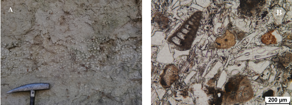
Figure 7. A) Accretionary lapilli (‘tuff pearls’) bearing layer within a thick silicic volcaniclastic deposit produced by a large explosive volcanic eruption 14.4 million years ago (Vadászgödör locality). Accretionary lapilli was formed in a steam-rich eruption cloud and preserved uniquely in the shallow marine environment. B) The shallow marine deposition is proved by the microscopic studies: a mixture of various fossils and fresh glass shards.
The Root-Zone of Andesitic Volcanoes
The whole area of the NNUGGp experienced uplift in the last few million years at various levels and this caused significant erosion. As a result, the upper portions of the volcanic edifices were removed and the root-zones as well as shallow depth subvolcanic bodies were revealed. Around 14–15 Myr ago, an andesitic volcanic complex with small-sized stratovolcanoes and lava domes developed between the Börzsöny and Mátra Mountains in the present area of Cserhát (Póka et al. 2004). At present, only necks, radially distributed long dykes and in some places segments of the stratovolcanic edifices can be observed that serve as an opportunity to see inside volcanoes. The necks occasionally show columnar jointing of andesitic rocks such as at Szanda and Bér (Figs. 1 and 8), which complements the columnar jointed basaltic occurrences in the Nógrád-Gemer volcanic field. At Sámsonháza (Figs. 1 and 9), the alternation of pyroclastic beds and andesitic lava rocks seem to provide an example of classic stratovolcanoes, although more recently Di Capua et al. (2021) pointed out that the lower andesite body could be a sill, which shows an irregular contact and a peperitic mixture with the overlying pyroclastic material. This interpretation gives an additional natural value to this well-visited locality. At the northwestern part of the NNUGGp, the Páris Valley (Fig. 1) gives an insight into the high-energy, gravel-bed braided-river system at the foothills of an andesitic volcano. This is a popular touristic locality, called ‘Palóc Grand Canyon’, where explanation panels guide the visitors on how fluvial erosion and lahar deposition occurred at the Lysec palaeovolcano (Bordy & Sztanó 2021).
Among the unfolded subvolcanic structures, the Karancs, a notable flat hill, called ‘Palóc Olympos’ right at the Hungarian and Slovakian border deserves special attention. It is composed of andesite, but the unique feature is the occurrence of rounded almandine crystals, a type of garnet (Lantai, 1991; Harangi et al. 2001). Almandine is a rare mineral phase in volcanic rocks worldwide because it forms at high pressure (>700 MPa; Green 1977), i.e. mostly in the lower crustal magma reservoir and is not stable at shallower depth. This means that almandine dissolves if the magma stalls in a shallow crustal magma reservoir, which is usually the case in andesitic to dacitic magma evolution. Preservation of almandine suggests that this magma and many others around the NNUGGp ascended fast from the lower crust even though that they had high viscosity. Harangi et al. (2001) explained this particular situation by the change of tectonic condition, i.e. a transition from compressional to tensional stress field. Thus, the occurrence of garnet in this andesite is not only an internationally rare phenomenon, but demonstrates the peculiar origin of the andesitic volcanism in this region; this occurred as a response to lithospheric extension rather than due to active subduction (Lexa and Konečny 1974; Harangi et al. 2007).
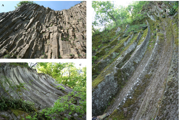
Figure 8. Erosion unfolded the deep root-zones of andesitic volcanoes: A) Thin, vertical columns in the vent-facies andesite at Szanda; B-C) Concave curvilinear columns rare worldwide in the andesite of Nagy Hill, Bér.
Variation in Columnar Jointing
Columnar jointing in volcanic rocks is formed during the slow cooling of lava resulting in polygonal cracking due to the contraction of the solid material (Toramaru & Matsumoto 2004; Goehring & Morris 2008; Hetényi et al. 2012). When the lava rock subsequently crops out, these cracks are slightly broadened by precipitation, wind erosion and temperature variation (i.e. freezing and thawing). The fracture pattern then slowly transforms into regular columns yielding a spectacular view, which attracts people. The NNUGGp offers a great opportunity to observe a wide variation of columnar jointing patterns of lava rocks, both in basalt and andesite; some of them show features that are rare worldwide.
The route of columnar jointed lava rocks starts at the southern tip of the geopark area, where columnar jointed structure developed in andesite. Nagy Hill, at the village of Bér, provides an exceptional outcrop (Fig. 8B-C). Here, concave curvilinear columns of an andesite body occur, which is a very rare natural phenomenon. This is called an ‘andesite-slide’. These curved columns were formed when the relatively fluid andesite lava filled a wide crater or vent or flowed into a valley and cooled down slowly at its margin. Contraction during cooling resulted in joints or fractures perpendicular to the cooling surface, i.e. to the wall of the valley or the crater. The concave, long columns of the andesite place this locality internationally in a first-class category. Close to this locality, another columnar jointed andesite is found (locality Szanda; Fig. 8A). Entering the basalt volcanic field, further columnar jointed lava rocks occur. Among them, a peculiar feature is shown by the Šomoška/Somoskő locality (Fig. 1 and 10A-B), where convex curvilinear, 15–20 cm wide pentagonal and hexagonal columns can be observed (Konečny et al. 1995a; Lexa et al. 2010). It is called a ‘petrified waterfall’ because of its appearance. The intermittent collapse of the tall and steep cliffs has resulted in a wide talus at the foot of the lava rock body. The exceptionally regular curvilinear basalt columns place this locality in the special category of natural wonders, such as the world-famous Devils Postpile National Monument, California, USA, the Devils Tower National Monument in Wyoming, USA, the Organ Pipes National Park in Australia and the ‘Organ Pipes’ formation on Mount Cargill in New Zealand. This was even mentioned by Zipser (1817) and Beudant (1822), who documented the geological beauty of the Carpathian Basin for the first time. Furthermore, this spectacular geoheritage meets the cultural and historical heritage, since a ruin of a medieval castle sits on the basalt columns (Fig. 2). It is only a couple of kilometers from this locality to Szilváskő, where 20 to 25 m tall vertical basaltic columns called ‘basalt organs’ are found (Fig. 10C). Next to the dazzling basaltic formations, a rare combustion metamorphic complex that consists of clinker, buchite, ‘paralava’ and brecciated rocks is found close to Szilváskő. Presumably the combustion of the near-surface Miocene coal occurred after the basaltic eruption and before the modern-day mining activities based on the geomorphology of the terrain (Horváth et al. in prep). Further small outcrops of such features are common in the geopark area.
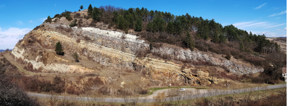
Figure 9. Exposure of a portion of a Mid-Miocene andesitic stratovolcano (Sámsonháza): alternation of pyroclastic and andesitic lava layers. However, a recent study (Di Capua et al. 2021) showed that the lower andesite layer could have been a shallow sill, which has an irregular, peperitic contact with the pyroclastic material.
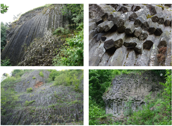
Figure 10. Variation for columnar jointing structure of basalts: A-B) Curvilinear, pentagonal and hexagonal columns at the outer portion of vent facies basalt at Šomoška/Somoskő. C) Long vertical columns of vent facies basalt at Szilváskő; D) Two-tiered columnar jointed basalt lava at Szilváskő
Variously Eroded Volcanoes of a Monogenic Basalt Volcanic Field and the Use of High-quality Rocks
In the CPR, several monogenetic basalt volcanic fields (Connor & Conway 2000; Németh 2010; Valentine & Connor 2015) have been developed for the last 8 Myr. One of them, called Nógrád–Gemer volcanic field (Jugovics, 1940a,b, 1944; Szabó et al. 1992; Konečný et al. 1995a, b, 1999, 2002; Dobosi et al. 1995; Lexa et al. 2010; Harangi et al. 2015b) is found in the area of the NNUGGp. This volcanic field has had a long-lasting intermittent eruption activity that started around 8 Myr ago (Konečný et al. 2002). The last eruption occurred a little bit north from the northern margin of the NNUGGp only at 100 ka (Putikov volcano at Brechy, Šimon & Halouzka 1996; Šimon & Maglay 2005), whereas the 1200–400 ka eruptions were the latest (e.g., Fiľakovo/Fülek; Hodejov/Várgede, Ragáč/Ragács, Dunivá Hora scoria cone at Medvedia/Medves lava plateau; Fig. 1) within the geopark area. The several million year duration of the volcanism as well as the long repose times between active phases (>0.5 Myr) are not uncommon in basalt volcanic fields, particularly in tectonically-controlled, low magma output continental fields (Valentine & Perry 2007). Thus, this volcanism is of key interest at the international level, not only because it shows many characteristics of monogenetic volcanic fields, but also because further eruptions could take place. Interpretation of magnetotelluric data showing the electric conductivity properties suggests a small volume of interconnected melt in the uppermost mantle beneath the volcanic field (Patkó et al. 2021).
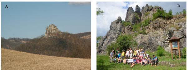
Figure 11. The regional uplift and the accompanying erosion removed the loose pyroclastic deposits of the basalt volcanoes, while the vent zones (diatremes) containing more resistant volcaniclastic rocks and basaltic feeder dykes remained as steep cliffs (Hajnáčka/Ajnácskő). These are typical landforms of the NNUGGp and popular tourist destinations.
This volcanic field involves almost all eruption styles characteristic of continental basalt volcanism. There are maar volcanoes where diatomitic clay or specific oil shale/alginite accumulated in the deep crater lake (Vass et al. 1997, 1998). Diatremes, i.e. deep vents filled by smaller and larger falling-back rock material during explosive events of maar volcanoes, are spectacularly exposed at Tachty/Tajti and Stará Bašta/Óbást. Phreatomagmatic eruptions led to the formation of tuff rings, which have been poorly preserved because of erosion. However, their vents and the deep feeder dykes (e.g., at Šurice/Sőreg and Hajnáčka/Ajnácskő; Fig. 11; Konečný et al. 1995a,b, 1999; Lexa et al. 2010) have occasionally been well preserved. They are built from palagonitized tuff breccia with fragments of basement rocks cut by narrow basaltic dykes. On the upper part of the Šurice/Sőreg cliff even the initial maar-volcanic beds overlain by the subsequent Hawaiian spatter deposits can be observed. Another remarkable natural value of the Hajnáčka/Ajnácskő locality is the accumulation of mammal skeleton fragments in the ‘Bone valley’, which is type locality of Zone MN16 and/or Mn16a of the European Neogene Mammal time-scale (Vass et al. 2000). After the maar-volcanic eruption, the wide crater was filled by water and finely laminated sediment was deposited in the lake. It is thought that animals came to the crater lake killed by postvolcanic gas emanations (presumably carbon-dioxide) and their bones were reworked into the lake along with the loose volcanic material. Subsequent erosion removed the loose volcanic material and exposed the diatreme (Konečný et al. 1995, 1999) as well as the lacustrine deposit with the fossils. The age of the subzone is 2.8–3.3 Myr and this corresponds to chron C2An. Probably, one of the youngest volcanoes of the geopark area is right in the center of the town Fiľakovo/Fülek (Fig. 1 and 12). The age of the volcanic eruptions is thought to be around 500 ka, as indicated by relations to river terraces. The castle hill, together with the nearby Červeny Hill are deeply eroded remnants of two volcanic craters (maars/tuff rings), built by palagonitized lapilli tuff beds dipping toward the former crater center (Fig. 12A). Several slides and faults indicate strong seismic activity during volcanism and/or structural reworking into the deep crater. Peculiar, baked Miocene sedimentary fragments with limonite crusts can be found occasionally within the lapilli tuff beds (Fig. 12B). This locality is the center of the Slovakian part of the geopark, where a visitor center exhibits the main geoheritage values of the area.
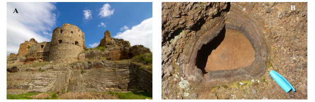
Figure 12. The Slovakian gateway of the Novohrad–Nógrád UNESCO Global Geopark: The medieval castle of Fiľakovo/Fülek was built on the remnant of the youngest (400 ka?) basaltic maar-volcano. The thinly layered volcaniclastic deposit contains abundant baked sandstone bombs.
In the Nógrád-Gemer volcanic field, various structures of basaltic lava flows and associated scoria and cinder cone volcanic products can be observed. The Salgó-Boszorkánykő area has a particular atmosphere not only because of the volcanic features but also the cultural and historical heritage as well as the legends associated with this place. Salgó Castle, which can be seen from different directions (Fig. 2), was built on columnar jointed basalt. The ruin of the castle was visited also by Sándor Petőfi, one of the most famous poets of Hungary, who was very much inspired by this place and wrote the following lines in his poem: “Perhaps there wasn’t a castle in Hungary, which would have been as close to the stars as Salgó. I sat at its top for a long time: my gaze roamed for miles, my soul roamed for centuries”. A short nature trail leads the visitor from the castle to the Boszorkánykő, which is translated as Witchstone (Fig. 13A). Along the nature trail, examples of Hawaiian spatter deposits can be observed. It ends with a steep, vertical cliff, where legends say that witches used to gather on this high basalt hill in the foggy weather and danced to send hexes on the villagers. According to other narratives, women who proved to be witches were knocked down from here.
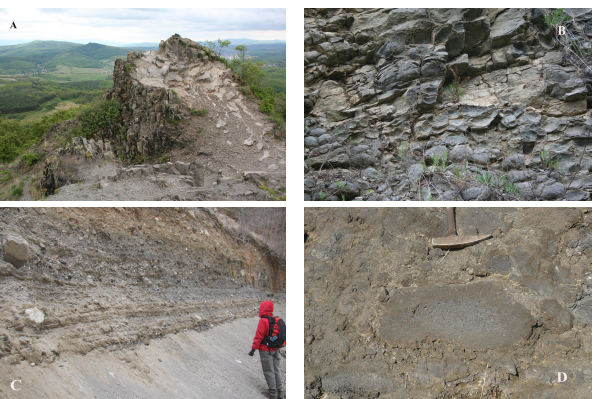
Figure 13. Selected volcanic geosites representing the geoheritage of the basaltic volcanism: A) Steep cliff of platy-jointed lava body at Boszorkánykő (‘Witchstone’), where various legends arisen; B) Globular weathering of the lava rocks of the Medves-Eresztvény locality; C) Characteristic unsorted, lithoclast-rich phreatic volcaniclastic deposit formed by initial maar-volcanic eruptions. D) Within the wide maar crater, the eruption style subsequently changed to pure magmatic explosive eruptions: agglomerate consisting of basaltic spatter bombs (Duniva hora, one of the youngest basalt volcanoes of the NNUGGp north of the Medvedia/Medves lava plateau)
High-quality basalts were quarried at several localities. Among them, the Mačacia/Macskakő quarries were opened in 1880 and were active for over 50 years. The paving blocks were famous for their high quality and were transported to several countries of Europe, even to London. They can be still found in the small streets of Budapest and Vienna. Their name (‘macskakő’ in Hungarian, ‘Katzenkopfstein’ in German) is used for such basalt cubes and the name comes from this quarry. At that time, quarrying was performed by hand tools. Contraction cracks, the columnar joints formed during the cooling of lava helped the production of regular ‘macskakő’, i.e. basalt cubes. Wedges were hit into the cracks of the basalt walls by a club to strain them. Basalts were cleaved from the quarry wall and then stone-cutters poured water onto these rocks looking for further cracks. These fractured (named ‘fevered’ rocks) blocks of basalts were cleaved along the cracks. Carved paving stones and cobblestones were piled up to protect them from the strong sunshine, which worsened the quality. The rocks were transported by rail. German quarriers and stone-cutter workers called ‘ritzer’ had hard labour in week-long shifts and therefore they built lodges near the quarries. They got water from the nearby springs and kept only the most necessary things in their houses. Remnants of stone-cutter lodges can occasionally be found, although they are now occupied by huge trees. There is a 2.5 km long easy walking nature trail either starting from Šomoška/Somoskő or Šiatorská Bukovinka/Sátoros with 10 stops where explanation panels tell the stories of the volcanism as well as the quarrying activity. The content of these panels needs, however, an update. In the quarry, several lava flows and intercalated pyroclastic beds are exposed.
The Largest Basalt Plateau in Central Europe
Sitting right on the border between Slovakia and Hungary, the 2.2–1.3 Ma Medvedia/Medves lava plateau with its 19 km2 areal extent and ca. 1 km3 volume (Kereszturi & Németh 2011; Fig. 1) is the largest in central Europe. It is a polygenetic and polymagmatic volcanic structure, with several eruption centers comprising two well-preserved scoria cones (Medvedia výšina/Medves magasa and Duniva hora) and a lava field-filled set of valleys. The latest eruptions occurred at Duniva hora (Fig. 13C-D), and there can be seen fine examples of volcaniclastic deposits formed by phreatic maar-type eruption as well as flattened vesicular spatter clasts and clastogenetic lava related to the lava fountain activity of a 1.3 Ma old cinder cone.
In the past century, high-quality basalt was excavated in several quarries. Presently, most of the abandoned quarries are protected and nature trails with explanation panels help visitors to understand how lava flows and explosive volcanic products were formed. Platy-jointed and columnar jointed lava rocks as well as specific alteration features, such as globular ‘stone balls’ can be observed here (Fig. 13B). These ‘stone balls’ may have formed fairly recently due to insolation and strong daily temperature fluctuation affected the dark-colored basalts in the exposed quarry walls. German stoneworkers (‘ritzer’) called them ‘Sonnenbrennerbasalt’, i.e. sunburn basalt. A few cm-sized pyroxene and amphibole megacrysts (Dobosi et al. 2003) occur frequently in the basalt. These crystals are witnesses of the magma evolution at the crust-mantle boundary, where mantle-derived magma accumulated and often solidified without feeding volcanoes. Beneath the lava flows, pyroclastic deposits of hydrovolcanic eruptions are occasionally found. Among them, a well-layered tuff at Eresztvény contains abundant olivine, pyroxene and amphibole in addition to palagonitized glass shards, quartz and muscovite crystals, therefore it is called ‘crystal-tuff’ (Fig. 14). Since this is one of the rare natural values, the explanation panel notes ‘please protect and don’t collect’. The main visitor center of the Hungarian part of the geopark was built at the southern edge of the Medves Plateau, where visitors can get useful information about the geopark services. A little bit further, at the small village of Salgóbánya, the House of Geological Miracles includes an interactive exhibition about all the natural values of the NNUGGp.
A Stony Message from the Upper Mantle
Basaltic magmas often ascend rapidly and incorporate fragments from the upper mantle and the crust en-route. In the NNUGGp, there are several localities where tiny (a few cm in size) clasts of peridotite and pyroxenite xenoliths and in particularly large, (>1 cm) amphibole and pyroxene crystals, called megacrysts are found. These xenoliths and megacrysts provide an opportunity to study directly the upper mantle part of the Earth’s interior. While peridotites represent the characteristic lithology of the upper mantle, the pyroxenites and the megacrysts are witnesses of the magmatic processes occurring at the crust–mantle boundary zone. Careful studies, especially the scientific results by Csaba Szabó’s group (Szabó & Taylor 1994; Szabó and Bodnár 1995, 1996; Zajacz and Szabó, 2003; Kovács et al. 2004; Zajacz et al. 2007; Liptai et al. 2017; 2019; Patkó et al. 2019, 2020, 2021) underline the importance of this area, where processes in the upper mantle and lower crust can be reconstructed. A notable recent result (Patkó et al. 2021) shows that an incipient, but interconnected melt fraction may still be present beneath the Nógrád-Gemer basalt volcanic field as indicated by electrical conductivity geophysical investigation (magnetotelluric survey) and observations on peridotite. The xenoliths and the megacrysts have great scientific value and therefore these localities need to be protected, and collecting by visitors should be controlled.
Discussion: Geotouristic and Geoeducational Offers Within the NNUGGp
Nature Trails
The NNUGGp has a particular situation as a trans-border geopark. It comprises areas of southern Slovakia and northern Hungary with people speaking different languages, having different cultures and there are different methods of nature protection. Nevertheless, a significant Hungarian population lives in the Slovakian part of the geopark and this helped as a bridge to communication and in joint efforts to build up a live geotouristic and geoeducation offer. The geopark partly through its stakeholders offers spectacular tours through the wide range of volcanic outcrops into the volcanic past, when destructive pyroclastic flows covered large areas, andesitic lava domes extruded into the surface or stalled just beneath it and finally a basaltic monogenetic volcanic field was developed with lava fountains, phreatomagmatic explosive eruptions and long lava flows. Human activity (like quarrying, mining, road-cutting etc.) helped in exposing the spectacular volcanic heritage of the area, and all of these together established the basis of the geopark philosophy. Science added a strong contribution to establishing how these events happened.
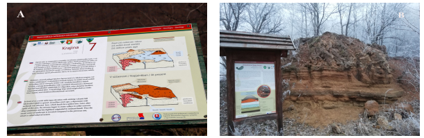
Figure 14. A) Information panel in the Mačacia/Macskakő Nature trail explains the geological evolution in three languages. B) Explanation of the volcanological structure at the Eresztvény quarry, the southern part of the Medvedia/Medves lava plateau.
Most of the abandoned quarries in the NNUGGp are now formally protected and serve as geosites, where visitors can understand how the past volcanic eruptions affected the areas and also they can recognize the particular natural values. Many quarries were cleaned, and study paths were created with explanation panels (Fig. 14). There is even a popular cross-border nature trail from Šiatorská Bukovinka/Sátoros through the Mačacia/Macskakő quarry to Šomoška/Somoskő. These nature trails along with the geological information panels were new in this disadvantaged area and they helped in geoeducation as well as in the recognition by local people of what natural values are in their backyards. They attracted people and led to the discovery of the hidden geoheritage of this area. Information panels were planned to provide concise summaries of the principal geological features in three languages (Slovakian, Hungarian and English). However, there is still a strong need for improvement of the content of these explanation boards at many places as well as redesigning them in a common template to provide more effective explanations to visitors.
Visitor Centers and Volcano Day Events
There are four main visitor centers in the area of the NNUGGp. The Ipolytarnoc Fossils Nature Reserve (https://www.osmaradvanyok.hu/en) is one of the main gateways, where high-tech interpretative tools were introduced in 2007 to show and reconstruct the paleohabitat, which was destroyed and at the same time conserved by a volcanic catastrophe, as a kind of ‘Prehistoric Pompeii’. 4D movies, touch-walls, AR tools, semi-holographic shapes of track-making Miocene animals projected above their in-situ footprints within sheltered excavations are involved in the exhibitions. Its reshaped building blends into the landscape (Fig. 3A), and its structure immediately attracts the visitor’s attention. Its main corridor represents the inner cavity of the giant petrified tree. There are regular guided tours along the geological trails where first-hand explanations are given at outcrops about what the rocks can tell about the geological history of the area. At the end of the tour, visitors can see a wide variety of exposed footprints in a large exhibition hall and they are guided by a 3D show to around 17 Ma into the geological past.
The annual European Geopark Network Week offers a great opportunity to disseminate knowledge about volcanoes and volcanic processes and this led to the idea of the Volcano Day program (Fig. 15). From the geopark's perspective it became an important tool for educating the public. School buses from both countries fill the parking area and the interactive volcano observatory show runs 2–3 times to great interest. After a brief introduction about the nature and reactivation of volcanoes after a long dormancy, children are selected from the audience and are involved in the show as researchers of a volcano observatory. Through the interactive role play, they get to know where the magma come from, why and how it erupts and how this can be detected. Each of them plays the role of a scientist who performs seismic monitoring, geodesy, and gas monitoring, among others and also a volcanologist, who reconstructs the eruption history of the volcano based on the study of volcanic rocks. All of these are necessary to forecast a volcanic eruption and by gathering the information, a simple evacuation plan is constructed. At the end of the show, a truly spectacular volcanic eruption occurs, a kind of Strombolian-type firework eruption simulation, which always excites the audience. This program helps to raise awareness of volcanic hazards as well as providing insights into how volcanoes work. Besides the volcano show, there are additional programs such as blind-touching rock tests to recognize the geopark's volcanic rocks (basalt, andesite, dacite and rhyolite types). Usually, more than 600 people take part in each Volcano Day event, which the children consider great fun. Interpretation of geological processes in a playful way can be rewarding even for the teachers.
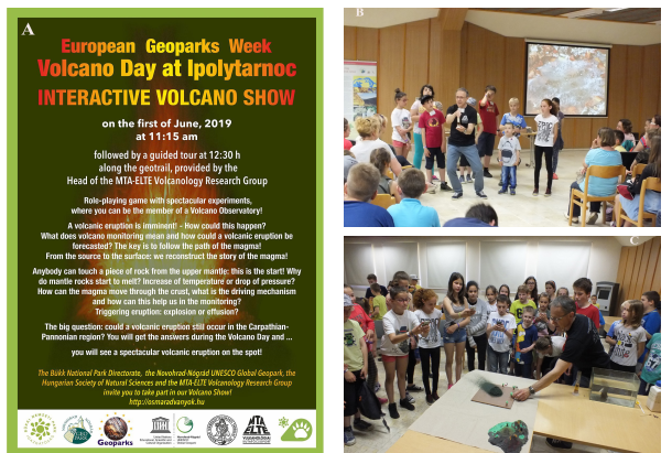
Figure 15. A) Snapshots of the regular Volcano Day program organized by the NNUGGp in the Ipolytarnóc Visitor Centre during the annual European Geopark Network Week. B and C) The interactive volcano observatory show, which attracts school groups and families, provides insight how volcanic eruptions can be forecasted, where the magma is formed and how magma ascends to the surface.
The Geopark’s Headquarters and Visitor Center was built at Eresztvény right at the southern foot of the Medvedia/Medves lava plateau, which extends from the Hungarian to the Slovak side of the Geopark. Visitors can be given advice about guided tours, maps and further useful information about the life of the geopark. This is the place where the two-day long Medves Photo Marathon competition held on a biannual basis is organized and attended by hundreds of multinational amateur photographers. The main idea is that those who attend the Photo Marathon become more aware of the beauty of the landscape and geological assets. They are educated on how to behave in protected areas by sharing their photos and increasing the public interest, by presenting them via social media platforms and by exhibitions within and outside the Geopark.
Further east, in the small mining village of Salgóbánya, the House of tGeological Miracles was opened in 2015. It offers an interactive exhibition, a 3D movie and the visitors even touch the most common rocks of the geopark area. The Slovakian center of the NNUGGp is in Fiľakovo/Fülek, where a ruin of medieval castle was built on the remnants of one of the youngest volcanoes of the geopark. The Castle Museum gives information not only about the history and culture of the area but also about the main natural values.
Geoeducation Efforts
The Novohrad and Nógrád areas are highly disadvantaged regions in many aspects, where raising interest in natural values through the geopark philosophy has been a great challenge. Therefore, a specific website was created (so far in the Hungarian language), where various educational materials are freely accessible for elementary and secondary school students as well as teachers (https://www.nogradgeopark.eu/hu/oktatas-1). A geopark board game and summaries about volcanological, geological and other natural and historical values of the geopark area can be downloaded and used in class sessions and at home independently.
Joint artistic and educational competitions are organized each year by the geopark partners (the Hungarian Bükk National Park Directorate and the State Nature Protection Office of the Slovak Republic) like the "Together we protect nature" contest on the Slovak side of the Šomoška/Somoskő castle for high school students. School children have to listen to the field lectures provided by professionals. After the transfer of knowledge, the teams have to prove their knowledge of botany, geology, dendrology and zoology of the geopark at several stations on the Medvedia/Medves Basalt Plateau.
Conclusions and Perspectives
The NNUGGp was established in a relatively poor part of Hungary and Slovakia, but the geopark philosophy helped to raise attention and tourism. It is an evolving geopark, where new attractions serve geoeducation and geotourism in parallel with geoheritage conservation management. There are plans for further expansion of the tourist offer, extending the interpretation of the rich volcanic heritage of the geopark with high-tech interactive tools (e.g., development of a specially designated Volcano House at Ipolytarnóc Fossils) and for the rehabilitation of former quarries covered by vegetation. There are ongoing scientific studies on volcanism on both sides of the border; their results are incorporated immediately into the exhibitions. Knowledge of how this landscape evolved through millions of years and how societies interacted with it through centuries is the strong basis of the geopark, which contributes to the well-being of the inhabitants of this transnational living landscape, this ancient world without borders. To preserve the volcanological features of the geopark, geotourism has to be planned, controlled and monitored, opened to less vulnerable and safer places. Education is an important tool, but legal means also should contribute to the successful safeguarding of the unique geoheritage. Law enforcement by the nature conservation ranger service can be a kind of guarantee for that. To widen the circle of public endorsement there are planned citizen science projects to strengthen the involvement and engagement of non-scientific stakeholders. The interpretation of the volcanological heritage uses easy-to-understand terms, explanatory figures and illustrations, recognizing that overly scientific formulation is ineffective and intimidating for laypeople. This crossborder geopark, which uses two different languages and systems, had to create a common layout, and visual appearance concerning publications, social media platforms, events and geoeducation, so that the image of the geopark could be clearly identifiable in both countries and elsewhere. By maintaining this, the geopark's identity and brand can be kept and strengthened in the future.
Acknowledgments
Studies of the silicic volcanic rocks in the Novohrad-Nógrád UNESCO Global Geopark area belong to the research project funded by the National Research, Development and Innovation Office–NKFIH within the FK OTKA project (No. FK 131869). Réka Lukács’s studies are supported by the Bolyai János Research Fellowship. The comments of two reviewers helped to improve the original manuscript and are appreciated.