Introduction
The North West Highlands Geopark is the source of probably the earliest evidence of terrestrial life to be found anywhere in Europe. Mats of simple-celled microbial life forms left their marks in sandstones of the Torridonian, including on ancient land and lake-bed surfaces of the Stoer Group rocks dated at 1.2 billion years old, and Torridon Group dated at 1.0 billion years old. Organic-walled microfossils in the Stoer and slightly younger Torridon Groups present the oldest evidence for terrestrial eukaryotic life (specialized cells with a nucleus) on Earth.
The North West Highlands Geopark is large, covering the entire far north-western corner of the Scottish mainland, and area of 2000 km2 of mountain, peatland, beach, forest and coastline across west and north-west Sutherland (Fig. 1). It encompasses a long stretch of heavily incised coastline, beginning near the small, but busy ferry and fishing town of Ullapool in the south, around Coigach and past the smaller coastal ports of Lochinver and Kinlochbervie, round Cape Wrath and the village of Durness towards the Kyle of Tongue. The eastern boundary of the Geopark extends from Durness and beyond Loch Eriboll to follow the Moine Thrust Zone, a key feature of the tectonic history of the British Isles.
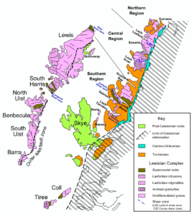
Figure 1. Map of the North West Highlands of Scotland, showing the geographic distribution of the main Precambrian rock units. The map is by Mike Norton, registered as CC BY-SA 3.0 with Wikimedia.
Geological Setting
The Precambrian rocks of north-west Scotland may be divided into the older Lewisian Gneiss Complex, mainly heavily metamorphosed rocks of Archaean and Palaeoproterozoic age (3000–1700 Ma), overlain by the Torridonian, an informal term applied to a long succession of Mesoproterozoic and Neoproterozoic sandstones and mudstones. Here, we focus on the Torridonian, source of the fossils. The Torridonian comprises three major rock successions, the Stoer, Sleat and Torridon groups (Fig. 2), which overlie the Lewisian Gneiss unconformably (Fig. 3A).
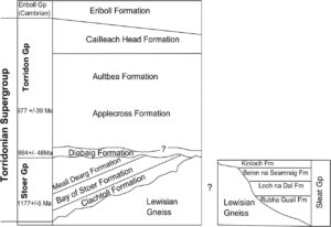
Figure 2. Summary stratigraphy of the Torridon Group of north-west Scotland, with radiometric age dates from Parnell et al. (2011) and Turnbull et al. (1996). From Brasier et al. (2016).
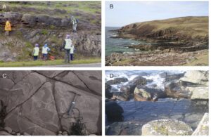
Figure 3. Figure 3. Spectacular geology of the Precambrian in the North West Highlands Geopark. A) The Lewisian-Torridonian unconformity (at the feet of the person in the blue hard hat). B) The Bay of Stoer Formation (Stoer Group) at Bay of Stoer. C) Desiccation cracks in red mudstones of the Bay of Stoer Formation (Stoer Group) at Bay of Stoer. D) Ripple marks in the Clachtoll Formation (Stoer Group) at Diabaig. Photographs by Pete Harrison (A) and Alex Brasier (B–D).
The Stoer Group, a 2 km-thick succession of continental sandstones and siltstones (Park et al. 2002; Stewart 2002), outcrops mainly on the Stoer Peninsula, Assynt, and comprises three formations. First is the Clachtoll Formation, ranging in thickness from 0–190 m, a basal cobble-boulder conglomerate, followed by pebbly, coarse sandstone and medium to fine cross-bedded sandstone, with local beds of red mudstone, red muddy sandstone with desiccation cracks, ripple laminations and rare calcareous beds (BGS Lexicon). The sedimentology (Stewart 2002) is interpreted as small alluvial fans near the base, then fining-up successions from deeper water to subaerial exposure (desiccation cracks), and braided-river sandstones near the top.
This is followed by the Bay of Stoer Formation (Stewart 2002), up to 240 m thick, comprising red, coarse pebbly sandstone, thick bedded and with abundant cross bedding and soft-sediment deformation structures (Fig. 3B). Thinner beds of mudstone and thin-bedded mudstone-sandstone alternate, some with desiccation cracks (Fig. 3C), evidence of aerial exposure. Sandstone which represents the ejecta blanket of a meteorite impact during Stoer Group deposition (Stac Fada Member; Amor et al., 2008) and mudstone (Poll' a Mhuilt Member) occur at the top of formation. The Stac Fada Member was usually interpreted as a mudflow deposit, but a newer view (Amor et al. 2008; Parnell et al. 2011; Simms 2015) is that it represents the proximal ejecta blanket from an impact crater, supported by the occurrence of shocked quartz and biotite, plus reidite (a form of shocked zircon). The Poll a Mhuilt Member, on the other hand, likely represents deposition in a lacustrine environment, although a recent study offers an alternative interpretation that a 27m-thick section of the Poll a Mhuilt Member was marine-influenced (Stüeken et al. 2017).
Finally, the Meall Dearg Formation, at least 240 m thick, comprises pale red sandstones with bed thicknesses from 0.3–5 m, showing abundant planar cross bedding, and locally wave-rippled and with rare pebble beds. Trough cross-bedded sandstones in the uppermost part of the sequence suggest deposition by braided rivers (Lebeau & Ielpi 2017; McMahon & Davies 2018).
The Sleat Group may be partially equivalent in age to the Stoer Group, but it outcrops on the Sleat Peninsula on the Isle of Skye, and it cannot be correlated by mapping with the Stoer Group, but both underlie the Torridon Group (Stewart 1991). The Sleat Group is about 3.5 km thick and comprises the Rubha Guail, Loch na Dal, Beann na Seamraig, and Kinloch formations. However, these are not described further as the entire succession lies just outside the bounds of the Geopark.
The rocks of the Stoer Group were tilted before deposition of the Torridon Group began, as shown by a distinct angular unconformity (Stewart 2002). The Torridon Group comprises unmetamorphosed red beds with subordinate grey shaly mudstones, mostly the deposits of ancient river systems (Selley 1965; Williams & Foden 2011; Lebeau & Ielpi 2017; McMahon & Davis 2018), and it can be up to 7 km thick. The Torridon Group rocks are exposed over a wide area of the North West Highlands, from the island of Rum in the south-west to Cape Wrath, at the far north-west corner of the Scottish mainland. It comprises four formations, the Diabaig, Applecross, Aultbea, and Cailleach Head formations.
The Diabaig Formation (Stewart 1975), absent in some places and up to 500 m thick in others, is an arenaceous unit, beginning with a basal breccia containing clasts of the underlying Lewisian gneiss, which is overlain by flat-bedded sandstones that show channels and wave ripples (Fig. 3D), and interfinger with grey mudstones that may display mudcracks. Above these are thick beds of massive sandstones with sharp, erosive bases. The environment of deposition is interpreted as alluvial fans extending into ephemeral lakes, and the massive beds may be lacustrine turbidites.
The overlying Applecross Formation (Stewart and Donnellan 1992), up to 3 km thick, is primarily coarse sandstones, showing both trough and planar cross bedding. Most of the sandstones show evidence of synsedimentary deformation, perhaps liquefaction induced by seismic activity at the time of deposition, and some contain exotic clasts such as jasper and porphyry. The upper part of the formation comprises finer-grained sandstones. In places, palaeocurrent directions in the sandstones indicate deposition from large alluvial fans, up to 40 km in radius, coming in from the north-west (Williams 2001).
Next comes the Aultbea Formation (Stewart 1969, 1975), up to 2.5 km thick, comprising sandstones similar to those of the Applecross Formation, but finer grained and with fewer pebbles. The deposition was likely also in large river systems, and some showing evidence of subaerial exposure in the form of mudcracks and rain pit impressions.
Finally, the Cailleach Head Formation, up to 750 m thick, is sedimentologically similar to the underlying Aultbea Formation, but the sandstones are finer grained. These sandstones occur in clear 22 m thick cycles, starting from a basal erosion surface and fine sandstones, through grey shales with desiccation cracks, and planar cross-bedded sandstones with wave-rippled tops and trough cross-bedded micaceous sandstones. These cycles are explained as the products of repeated progradation of deltas into lakes (Stewart 2002).
Dating the great sequences of Torridonian sedimentary rocks has been difficult. The maximum age is constrained by radiometric dates on the underlying Lewisian Gneiss Complex of 1800–1600 Ma, and the minimum age by dates from the Lower Cambrian quartzite above, of about 544 Ma. Radiometric ages from the Torridonian suggest an age of about 1200 Ma for deposition of the Stoer Group (Parnell et al. 2010, 2011) and 1000–950 Ma for the lower part of the Torridon Group (Turnbull et al. 2006; Rainbird et al. 2001; Lebeau et al. 2020), indicating a gap of some 200 Myr between deposition of the two groups, and enough time for the uplift and tilting of the Stoer Group before deposition of the Torridon Group.
There are additional dates from rocks of the Torridon Group. The Diabaig Formation has yielded detrital zircons that yield ages clustered around 1100 Ma (Kinnaird et al. 2007). Detrital zircons from the Applecross and Aultbea formations suggest ages around 1100 Ma, and some even younger than 1000 Ma. These dates suggest that the Stoer and Sleat Groups were deposited before the Grenville Orogeny, before 1200 Ma, while the Diabaig Formation was deposited after the orogeny, after about 1090 Ma, and the remaining parts of the Torridon Group after about 1060 Ma (Kinnaird et al. 2007). However whole rock Rb-Sr dating of the shales of the Diabaig Formation yielded an age of 994 ± 48 Ma, and a similar approach on shales of the Applecross Formation yielded an age of 977 ± 39 Ma (Turnbull et al. 1996). The Stac Fada Member of the Stoer Group has yielded a more precise age of 1177 ± 5 Ma, from authigenic feldspars that were crystallized immediately after the emplacement of the ejecta blanket from the postulated impact event (Parnell et al. 2011).
These ancient rocks were affected by multiple major tectonic episodes. First, the Stoer Group rocks were tilted by regional tectonic activity in the extensional basins in which the sediments were deposited, before deposition of the Torridon Group. Then, later, all the rocks of the north-west of Scotland were affected by the Moine Thrust, dated from 437–415 Ma based on new measurements of ages of metamorphism and deformation along the line of the thrust (Strachan et al. 2020). The Moine Thrust zone forms the eastern boundary of the Geopark, and it runs from Loch Eriboll on the north coast, some 190 km south-south-west to the Sleat Peninsula on the Isle of Skye. The Moine Thrust was formed late in the Caledonian Orogeny, as the Iapetus Ocean closed, and the continents Laurentia and Baltica collided. The older Moine was thrust over the Torridonian (some parts the same age as the Moine) and younger Cambrian/Silurian. The thrust was from east to west, and the distance of tectonic displacement was as much as 200 km. Subsequent erosion has stripped off much of the cover to the west, but the Moine Thrust belt forms a clear margin to the Geopark, marked by a series of high cliffs and mountains.
The identification of the Moine Thrust resolved a long-running controversy in Scottish geology, where noted geologists including Sir Roderick Murchison saw the change from older rocks in the west to younger rocks in the east as part of a single rock succession, and the contrast in rocks to west and east of the Moine line as little more than differential metamorphism. James Nicol, at first convinced by Murchison’s view, then realised that a major tectonic event had to be involved to explain the rock successions and the fact that older rocks lay on top of younger rocks in places, notably at Knockan Crag; so began the Highlands Controversy, a great debate that lasted through the middle and later nineteenth century (Oldroyd1990). Murchison’s view is probably not so inexplicable as it might seem now; the relative ages of the overlying and underlying rocks were not clear and the puzzle was how the metamorphosed Moine could overlie unmetamorphosed Cambrian rocks. In the controversy, Murchison and Archibald Geikie, both directors of the British Geological Survey in succession, were ranged against Nicol, Charles Lapworth and other notables. The debate was resolved when the British Geological Survey eventually (Peach et al. 1907) accepted Nicol’s, Lapworth’s and their colleagues’ ideas, and incorporated and expanded upon those in the classic field geological survey, sometime after most of the earlier protagonists had died. The Moine Thrust was a part of the regional, Scottish, geological scene, but the scale of the process and the fact it was part of a world-wide series of tectonic events of great magnitude emphasises the importance of the history of this area as represented in the North West Highlands Geopark.
Key to assessing the significance of the fossils from the Torridonian is the assumption that the environments represented were terrestrial. In their review, Brasier et al. (2017) conclude that the entire Torridonian was most likely deposited in non-marine conditions. They note that the unconformity between the Lewisian and Torridonian was likely formed by fluvial erosion. They summarise evidence for deposition of the Stoer Group, with the Clachtoll Formation deposited in alluvial fans, terrestrial mudflats, and braided rivers, the Bay of Stoer Formation with playa lake sediments interlayered with those related to an impact possibly on dry land, and the Meall Dearg Formation interpreted as a series of alluvial transverse bar deposits. The Torridon Group, similarly, shows evidence of non-marine deposition throughout: Diabaig Formation (lacustrine), Applecross Formation (fluvial, alluvial), Aultbea Formation (lacustrine), Cailleach Head Formation (freshwater lake with prograding deltas).
Stüeken et al. (2017) used molybdenum and strontium isotopes to argue that sections of the Poll a’Mhuilt Member of the Stoer Group may have been deposited in seawater. Hence, their argument is that, while the majority of the sedimentary succession was non-marine, some narrow horizons might have been marine or brackish in deposition.
Palaeontological Evidence
Microscopic Fossils
There have been several reports of fossils of early life in this long sedimentary succession. The first was by Jethro Teall (1849–1924), Director of the British Geological Survey, and part of the team that produced the definitive work on the geology of the North West Highlands. Teall (in Peach et al. 1907, p. 688) reported possible organic remains in the Torridonian, minute spherical bodies and fibres within black phosphate nodules in the Cailleach Head Formation near Loch Broom. These would then date from rocks perhaps younger than 950 Ma. Later work (Diver & Peat 1979) suggested that lateral equivalents of the Cailleach Head Formation conformably overlying Aultbea Formation sediments occurred on Gruinard Island, and their content of sphaeromorphic acritarchs and cryptarchs, including the sheaths of filamentous cyanobacteria, indicate an Upper Riphean age (1000–650 Ma).
Rather older are the nannofossils reported by Downie (1962) from the Stoer Group in Stoer Bay dated at 1.2 Ma, perhaps the oldest body fossils from Europe (older Precambrian fossils are known from cherts in Australia, South Africa and Canada). Downie’s (1962) specimens came from processing shale sediments of the Poll a’Mhuillt Member of the Bay of Stoer Formation, and Cloud & Germs (1971) then reported more material from the same locality. The latter authors identified various poorly preserved sphaeromorphs, identified as Favososphaeridium variabilis Cloud and Germs, 1971, Protosphaeridium cf. P. parvulum Timofeev, 1966 and Protosphaeridium cf. P. acis Timofeev, 1966. In their review of early terrestrial life, Wellman & Strother (2015, p. 611) note that “This is probably the earliest unequivocal report of terrestrial aquatic microbial fossils, although at the time of publication their terrestrial provenance was not emphasized.” Parnell et al. (2010) were even able to use their analyses of sulphur isotopes in the Stoer Group as evidence for the widespread presence of sulphur-oxidising bacteria and that these ancient terrestrial environments were sufficiently oxygenated to support microbes that were adapted to oxygen-rich conditions on the early Earth.
Zhang et al. (1981) and Zhang (1982) described diverse microfossils from shales in the Aultbea Formation, all classified as acritarchs and ranging in shape from spheroidal to elliptical, and filamentous. In a further study, Strother et al. (2011) recognised more than forty different species of Torridon Group microfossil based on their shapes, which could be sorted generally into five types, (1) single-celled sphaeromorphs and other likely eukaryotic forms; (2) multi-walled and colonial forms; (3) organisms with complex morphologies; (4) prokaryotes; and (5) specimens with other characters. These authors identified some key eukaryotic characters in the specimens, including excystment features including median splits and circular pylomes. Wacey et al. (2014) showed that the exceptional preservation of these microfossils was probably caused by their entombment in very thin coatings of iron-rich clay, as well as phosphate, which probably precipitated out of the ancient lake waters onto the dead microorganisms before they could decay.
In their studies of organic microfossil remains preserved in phosphate from several levels in the Torridon Group, Battison (2012) and Battison and Brasier (2012) identified eight general morphological forms (Fig. 4), comprising a light and a dark version of each of these four: (1) isolated coccoids up to 450 µm in diameter; (2) clusters of coccoids up to 130 µm long including spherical to ellipsoidal cells; (3) non-septate filaments, comprising empty tubular sheaths up to 100 µm long; and (4) very rare septate filaments with cell walls. From the Torridon Group phosphates, and associated with reticulate patterns on bedding surfaces interpreted as microbially induced sedimentary structures (see below), Strother and Wellman (2016) reported an abundance of preserved Eohalothece. This was an ancient cyanobacterium that they suggest may have helped promote the fossil-preserving phosphate precipitation by releasing phosphate-trapping microcystins.
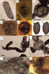
Figure 4. Microfossils from the Torridon Group, adapted from Battison (2012) and Brasier et al. (2017). A) Archaeoellipsoides bactrophycus. Sample CAI-7mac, macerate of phosphate from Cailleach Head Formation at Cailleach Head, scale bar is 20 µm. B) Globophycus minor. Sample CAI-2f, phosphate from Cailleach Head Formation at Cailleach Head, scale bar is 5 µm. C) Leiosphaeridia levia. Sample CAI-7mac, macerate of phosphate from Cailleach Head Formation at Cailleach Head, scale bar is 30 µm. D) Protosphaeridium parvulum. Sample CAI-2b, phosphate from Cailleach Head Formation at Cailleach Head, scale bar is 10 µm. E) Valeria lophostriata. Sample FLA-3a, phosphate from Diabaig Formation at Fladday, scale bar is 100 µm. F) unnamed genus and species, vesicle with complex cellular wall structure. Sample FFA1-1.45a, phosphate from Diabaig Formation at North Sheildaig, scale bar is 10 µm. G) same as for (F), scale bar is 10 µm. H) Archaeorestis unnamed species. Sample CAI-7mac, macerate of phosphate from Cailleach Head Formation at Cailleach Head, scale bar is 10 µm. I) Volyniella (or Obruchevella?) glomerata. Sample CAI-7mac, macerate of phosphate from Cailleach Head Formation at Cailleach Head, scale bar is 15 µm. J) Myxococcoides minor. Sample FFA1-1.45a, phosphate from the Diabaig Formation at North Sheildaig, scale bar is 15 µm. K) Myxococcoides staphylidion. Sample CAI-2a, phosphate from Cailleach Head Formation at Cailleach Head, scale bar is 10 µm.
Microbially Induced Sedimentary Structures, and possible Stromatolites
Prave (2002) reported microbially induced sedimentary structures (MISS) from the Stoer Group and the Diabaig Formation of the Torridon Group, ranging in age from 1200–1000 Ma. These MISS (Noffke et al., 2001) include wrinkle structures, interpreted as the remains of microbial crusts that infiltrated and bound the surface sand grains, and so definite evidence of abundant simple life, even if no organic remains of the fossils remain. Prave (2002) noted that the surfaces on which the microbial structures formed must have been exposed subaerially because they are associated with mudcracks and some soil-like features, which were presumably left behind in drying freshwater pools located some way from shorelines and river channels. Callow et al. (2011) carried out further field and laboratory studies on these MISS and identified a variety of types, indicating different microbial activities; they even noted a particular type of discoidal structures that resembled the Ediacaran fossil Beltanelliformis.
However, the status of these structures as stromatolites has been questioned. Brasier et al. (2019) reinvestigated several examples from the Clachtoll Formation and Poll a’Mhuilt Member and found that were layers of sand and mud that were deformed when they were still soft. Because of the lack of land plants with roots in Torridonian times, the sandy sediments were full of water. Deposition of muds on top of these wet sands caused the fluids to try to escape up through the muds towards the surface, thereby deforming the sediments into stromatolite-like domes. These stromatolite-like rocks are an interesting phenomenon that would have been much more common in the Precambrian than they are in the vegetated world of today, but they are not in themselves signs of ancient life (Brasier et al., 2019).
Designation as a Geopark
The NW Highlands Geopark was designated by UNESCO as a Global Geopark in 2015. The territory had already been admitted to the European Geoparks Network in 2004, an international cooperation that was pursued by several governmental and non-governmental organizations, including The Highland Council, British Geological Survey, Scottish Natural Heritage and local enterprise agencies in Wester Ross and Sutherland, together with a range of local stakeholders. In 2004, the Chairman of Assynt Community Council, Ron Evans, said: "It is very rewarding to learn that considerable efforts by national organizations and community groups, co-ordinated by The Highland Council, have resulted in the granting of Geopark status to the North-West of Scotland. Organizations in Assynt will continue their endeavors to promote local economic regeneration knowing that international recognition of the area as a special place will be invaluable." (Visit Scotland 2004).
Importantly, the NW Highlands Geopark achieved full UNESCO Geopark status in 2015. In 2019, the Geopark successfully passed its four-yearly review by UNESCO to determine whether the Geopark managers have continued to maintain the basic principles of effectiveness, and this includes its ability to fund core staff.
The realities are that sustaining funding for such geoparks can be difficult. In 2012 a community led Social Enterprise (North West Highlands Geopark Ltd) was set up to manage the Geopark instead of a publicly funded partnership and in 2016 this achieved charitable status. In 2017, the NW Highlands Geopark Charity faced a funding crisis and launched a crowdfunding bid for £70,000 in order to continue funding the core staff required to keep the Charity running (https://www.bbc.co.uk/news/uk-scotland-highlands-islands-39600900).
The importance of the Geopark, and reasons for its designation are summarised on the official website (https://www.nwhgeopark.com/landscape/the-geology-of-nw-highlands-geopark/) as:
“The North West Highlands Geopark contains geology and a landscape of world-class quality, significance and importance. There are five aspects, which make the Geopark unique:
- Some of the oldest rocks to be found anywhere in Europe (Lewisian Gneiss), as much as 3 billion years old. These are the “building blocks” of the Geopark and also the “building blocks” of Scotland.
- The “Cradle of Geology” where thrust faulting was documented by pioneering Victorian geologists, Benjamin Peach and John Horne. They demonstrated that older rocks could be pushed (thrust) towards, up and over younger rocks and further documented the Moine Thrust, based on its initial discovery by Charles Lapworth, now recognized as one of the most significant crustal dislocations of its type in North West Europe.
- The Geopark contains the earliest evidence of eukaryotic life to be found anywhere in Europe.
- It exhibits a unique relationship between its landscape and the underlying Geology, not seen to such a spectacular degree anywhere else, i.e. “The landscape is the Geology and the Geology is the landscape”
- A site interpreted to represent the ejecta deposits of a giant meteorite impact at 1177 ± 5 Ma.
Mission of the Geopark
According to the official website (https://www.nwhgeopark.com/our-geopark/), the mission of the Geopark Charity “is to be a thriving and sustainable rural economy capitalising on the assets and people of the Geopark in partnership with local government, relevant agencies and local businesses.”
“The current strategic objectives of the NW Highlands Geopark Charity are to:
- Promote the Geopark, in particular to partners, the local community, visitors and those seeking knowledge of the area’s geology.
- Encourage awareness of, and engage people with, the geodiversity, historical, cultural and economic importance of the area, and encourage further geological and related research.
- Sustainable Development. Work closely with businesses, educational groups, voluntary and statutory agencies to generate further employment and environmentally responsible and sustainable economic activity within the Geopark.
- Manage our organization and UNESCO status efficiently: Develop such systems, management structures and methodologies as are required to implement these strategic objectives.”
Public engagement
Touring
The Geopark is large, and so visitors do not necessarily get to visit everything on offer during one trip. Visitors are encouraged to visit the Rock Stop Visitor Centre and Coffee Shop, managed by the Charity’s Trading Arm, located at the center of the territory in the old school building at Unapool (Fig. 5A) for orientation. This offers various interpretation panels, interactive displays such as a Virtual Reality Time machine and Augmented Reality Sandbox, leaflets and guides to the park, encouraging visitors to drive and walk to see the countryside and learn something. Most visitors take this self-guided approach.
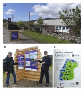
Figure 5. Geoconservation resources in the North-West Highlands Geopark. A) The Rock Stop, visitor center, Unapool. B) Geopod, or information boards at Rhiconich, Kinlochbervie. C) Sample information board. Photographs courtesy NW Highlands Geopark.
As an example, Nature Scotland created a driving itinerary for the Geopark containing around 15 interpretation panels. These are introduced on the official Geopark website in terms appealing to tourists whose knowledge of geology might be modest (https://www.nwhgeopark.com/rock-route/; the three-word terms are unique identifiers that provide exact location details to a 3 m x 3 m square via the ‘what three words’ website; https://map.what3words.com/). These locations, plus 3 other information points called geopods are identified by recently erected clear road signs (Fig. 5B, C).
- Ullapool ///surface.ties.daredevil Look out over the loch and trace the marks left by mountain building, glaciers and changes in sea levels.
- Strathcanaird ///collected.biked.verge An immense sheet of ice once flowed like a river over this land, carving the mountains before you.
- Stac Pollaidh ///vines.havens.hardening A mountain that the weather is gradually wearing down, enjoy it before it disappears.
- Knockan Crag NNR – the main event! ///herds.cake.motive Unlock the mysteries of one of the oldest landscapes in Europe. At Knockan Crag NNR Scotland’s story of ancient oceans, vast deserts and ice sheets, crashing continents and epic journey from pole to pole is told through poetry, sculpture and interactive exhibitions.
- Elphin ///stealing.pushy.adjusting Different rock types leave their own unique ‘signature’ on the landscape.
- Bone Caves ///sleepy.tank.retrieves Take a hike to the Bone Caves and see where geologists found the remains of some of Scotland’s lost animals.
- Stronchrubie ///snows.flips.suspends The forces that shape the landscape are still at work. Look for the evidence of erosion caused by glaciers.
- Inchnadamph Hotel ///tripods.flaked.recently World famous geologists stayed at this hotel as they explored the mountains.
- Loch Assynt ///tries.milkman.dentistry Meet some of the oldest rocks on the planet and discover how the landscape they formed was lost through time.
- Unapool ///hammocks.laying.folders The mountains across the loch carry the scars of two major thrust planes, where the Earth moved in a big way.
- Kylestrome ///watch.syndicate.confined Enjoy a stunning view over the mountains of Assynt, discover the story behind their names.
- Laxford ///weeds.reminds.counts Admire a slice through time, as revealed in the strange patterns and colours that usually lie hidden.
- Rhiconich ///triangle.acrobats.motor Look for the boulders on the skyline. An ice sheet lifted these 20,000 years ago and moved them many kilometres before setting them down.
- Kyle of Durness ///prance.limiting.alternate Get to grips with glaciers! Gaze in awe at their force gouging out the valleys then depositing sand and gravels around Durness.
- Loch Eriboll ///finds.nozzle.curly Discover the great Victorian controversy literally thrust before you, why is the grass greener on the other side?
At several of these locations there are also circular walks, some of them focused on geology, others on landscape, wildlife, and history (Fig. 6).
Guided Tours
In addition, the Charity offers guided tours to explore the geology and history of geology in more detail (Fig. 6A, B). These tours can be 3 or 6 days in duration, and they are led by knowledgeable park geologists, who guide visitors through the geological history of the area, visiting the Lewisian gneiss, the Scourie dykes, and the Torridonian, as well as aspects of the Pleistocene, including bone caves. On the final day, visitors go hunting for stromatolites on the Coigach Peninsula. These tours are offered in May, July and September each year, and they are designed to attract people with geological backgrounds as well as those interested in an outdoor adventure.
Because of the historical importance of the Lewisian and Torridonian geology of the Geopark, occasional tours of ‘The Highlands Controversy’ are also offered. These last for three or five days and take visitors to all the key spots studied by the early Scottish geologists, and subject of a well-known history of science book (Oldroyd 1990). From the website, the aims and content of the historical tour are described (https://www.nwhgeopark.com/geotours-2020-the-highlands-controversy/):
“This Geotour aims to follow in the footsteps of these pioneering geologists such as Roderick Murchison, Archibald Geikie, Matthew Heddle, James Nicol, Charles Lapworth, Ben Peach and John Horne amongst others by visiting the locations where they gathered their evidence. You will be accompanied by the North West Highlands Geopark Geologist Pete Harrison who will take you through the events as they unfolded and provide expert tuition on the various rock types to help you interpret the landscape. Pete Harrison has recently co-authored (with Malcolm Rider) the 2nd Edition of Hutton’s Arse which explores the Highlands Controversy as well as looking at 3 billion years of extraordinary geology in the Northern Highlands.
“The tour has been designed to appeal to those who may have undertaken a previous Geotour or have some previous knowledge or field experience. It will look at the structure and geological history of the Moine Thrust Zone in particular and how the theory of its formation gradually evolved over 50 years.
“Also included in the tour is a talk from Alastair Mitchell who will take you through his collection of original maps produced around the time of the controversy, to show how the ideas developed.”
This offering is meant to attract non-geologists and to show a wider public the importance of geoheritage, both in terms of the geology itself as we see it today, as well as in terms of a core series of episodes in the history of the subject that have regional, and also international, importance. A strong draw for visitors is that they are being instructed by experts who have written books on the subject (Rider and Harrison 2019). Further, the official Geopark website offers an extensive summary of the key points of these historical debates.
Other educational activities
The NW Highlands Geopark Charity offers lectures by guest speakers such as countryside rangers, Earth scientists, historians and ecologists, as well as setting up events later taken on by the community, such as the Reiff Climbing Festival. There are also ‘ranger walks’, short guided tours by Highlife Highland countryside rangers in partnership with the Charity to explore aspects of geology, wildlife, and human heritage (e.g. the Inchnadamph bone caves, bird song, rock pools, tree identification, wild flowers, snail identification, carved standing stones, history of crofting farming).
Although geology and history of geology justify the Global Geopark, visitors are drawn by other themes, and human cultural history is key for many. There are archaeological sites showing strong evidence of human occupation of these regions during the Neolithic Period (Cavers and Hudson 2010). These are followed by numerous Bronze Age and Iron Age domestic and agricultural archaeological sites, and later Norse influence evidenced by smattering of placenames and plausible architectural evidence (Ballin Smith 2020) and a burial at Balnakeil (Batey and Paterson 2012). Gaelic culture eventually overtook any Norse settlement and by the Medieval period, there was a strong Gaelic political and cultural system in the North West. Finally, there is evidence for continuing occupation by people engaged in subsistence agriculture, termed crofting, where people lived very poor lives up to the nineteenth century when whole areas were depopulated during the ‘Highland clearances’ and replaced by sheep. All of these aspects of human occupation have deep resonances that draw many visitors to the area.
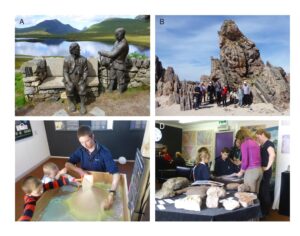
Figure 6.Geotourism and geo-education. A) Knockan Crag, a central point in understanding of the Moine Thrust, commemorated by a statue of Ben Peach and John Horne. B) A party of visitors on the beach just east of Durness on the north coast, one of many spectacular and scenic spots in the geopark. C) Families can construct landscapes and drainage patterns using the augmented reality sandbox. D) School children in the visitor center learning about rocks and fossils. Photographs by Peter Harrison, courtesy NW Highlands Geopark.
The Geopark Charity offers a range of teaching packs and school events (Fig. 6C, D). There are activity-information sheets for children as well as teacher sheets covering three main areas: Achmelvich, Clachtoll, and Loch Glencoul. These are for schools that wish to visit the area, and the sheets explain the basics of the geology and outline simple walking routes for the children and activities they can do to. Each visit spot has an information board (geopod; Fig. 5C) and the tasks are set out in the student sheet (Fig. 7) with further explanation to help the teacher to interpret the sites and make the experience rewarding. The student sheets are sometimes multiple pages and the teacher has to print these out, so each pupil has a sheet on which to answer questions and make drawings of what they see. In all cases, it is assumed that the teacher has no specific geological training but wishes to engage the children. The support information includes practical advice such as where to park the bus and basic safety precautions, as well as ideas about how to explain concepts of geology to the children (Fig. 8).

Figure 7. Example of a work sheet for children for the Achmelvich locality. © North West Highlands Geopark.
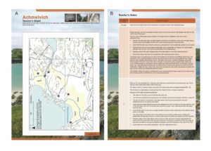
Figure 8. Example of the advisory sheet for teachers for the Achmelvich locality, A) showing the detailed map of locations to take the class and B) commentary on what can be seen. © North West Highlands Geopark.
The Geopark Charity also partners with Universities to deliver research projects and outreach activities to local residents and school pupils. A recent example of this is the Soil Fertility Research Project, delivered with National Lottery Heritage Fund support, matched by the University of Stirling as part of the Coigach Assynt Living Landscape partnership. The North West Highlands Geopark organized a program for School pupils to work with a PhD student to help with fieldwork and complete their own Higher Geography projects, learning more about geology and anthropogenic influence on soil formation.
Conclusion
The North West Highlands Geopark is one of the largest in Europe, at about 2000 km2. It covers a large portion of rather remote, but beautiful landscape in north-west Scotland, and has a long history of human occupation. However, economically, the area has always been sensitive, both because of its location on the North Atlantic Seaboard and because the people who lived there have adapted their own methods of agricultural strategies which have been historically interfered with by outside influence and depopulation. Tourists are attracted by these wild landscapes, and by the chance to walk over mountains and climb rock faces. Human cultural history and wildlife are important attractions.
The designation as UNESCO Global Geopark rests on the fact that the area shows excellent examples of some of the oldest rocks in Europe and the oldest evidence of life in Europe, represented both by organic-walled microfossils and stromatolites occurring at several levels in the Torridonian. The stromatolites may be seen in the field, but the microfossils can be seen only by study of rock samples under the microscope. Much recent work has shown that all these evidences of ancient life are preserved in sediments laid down in ancient rivers and lakes, although that is still debated, so it is likely these are the oldest evidences of non-marine life in the world. There are older traces of life, both in the form of stromatolites and microfossils from Australia, South Africa and Canada, but they are all in marine rocks.
Practicalities of running the Geopark is that political pressures in the United Kingdom mean that such endeavors are supposed to become self-sustaining according to a business model, and yet the reality is that this is impossible. North West Highlands Geopark Ltd can charge economic rates for sales of books and for guided walks and tours, and receive a small contribution from the activities of its Trading Arm selling souvenirs and coffee, but the salaries of geologists and rangers cannot be funded from such modest income sources. Funding from the National Lottery Heritage Fund provided good base-level funding for three years, but such awards can rarely be repeated, and the geoparks require sufficient government investment and policy provision (Gordon 2016). Maintaining the Geopark and providing the kind of informed access to an archive so rich in the natural processes that shaped our planet, one unmatched for its size anywhere in the world, relies on wide support from statutory bodies and from the public.
Acknowledgments
We thank Tony Prave and Dan Grigorescu for extremely helpful comments during the review process.