Introduction
The Kupferschiefer (in English: “Copper Slate”) and its equivalents (e.g., the Marl Slate in Great Britain) formed as sapropels on the bottom of the Late Permian Zechstein Sea extending from Great Britain in the west to Poland and Lithuania in the east. It is a stratigraphic marker horizon of the Upper Permian (257.3 ± 1.6 Ma; Haubold & Schaumberg 1985; Brauns et al. 2003; Paul 2006; Paul et al. 2018). The anoxic environment at the bottom of the Zechstein Sea prevented microbial decomposition of organic matter, which is why animal and plant remains, including soft tissues of marine and terrestrial vertebrates such as fish scales and gastric contents, are well preserved (Haubold & Schaumberg 1985). Specimens of Osteichthyes and Chondrichthyes are the most common vertebrate groups in the Kupferschiefer, with the ray-finned fish group Palaeonisciformes accounting for 90 % of the fossil record (Paul 2006). In addition, reptiles such as the gliding diapsid Coelurosauravus jaekli found in the Harz and Richelsdorfer Mountains in Germany and Yorkshire in England are also known from the Kupferschiefer (Pettigrew 1972; Schaumberg 1982; Frey et al. 1997).
In the UNESCO Global Geopark TERRA.vita (Fig. 1; hereafter called Geopark), NW Germany, the Kupferschiefer can be found at three transpressional uplifted elevations: Hüggel (south of Osnabrück, Lower Saxony), Schafberg (west of Osnabrück, North Rhine-Westphalia), and Piesberg (north of Osnabrück, Lower Saxony). Within these raised units, sediments ranging in age from Late Carboniferous to Middle Triassic are exposed within a small area of only a few 10 km² (Harms 1984; Josten et al. 1984). Each hill has its geodiversity and history of mining activity. The Hüggel area in particular is characterized by a large number of quarries and tunnels, which make the rocks accessible not only to scientists but to geotourists and hikers. The Geological Educational Trail, which connects quarries exposing the Kupferschiefer and mining-historical relics, was established at Hüggel in 1980 and is regularly updated by the Geopark (Harms 1995; Natur- und Geopark TERRA.vita 2009; Fischer 2020). Furthermore, the so-called Geocenter, a small museum of local geology exhibiting Kupferschiefer fossil finds from the region, operated in Hasbergen at Hüggel until 2018.
The most famous and valuable Kupferschiefer fossil from the Geopark area is a nearly complete skeleton of the archosauromorph reptile Protorosaurus speneri found at Schafberg, which is exhibited at the LWL Museum for Natural History in Münster (hereafter called LWL Museum; Grzegorczyk 2005; Gottmann-Quesada & Sander 2009; Ezcurra et al. 2014). Apart from this discovery, thousands of fish, plant and invertebrate fossils have been recovered by the LWL Museum from several excavation campaigns at Schafberg over the past 37 years (Schöllmann 2010). In contrast, the paleontological record of Hüggel has long remained rather incomplete. It was not until the 2000s and 2010s that this record was investigated in more detail during three excavation campaigns by local associations in Hasbergen with the support of the Geopark (Diedrich 2009; Müller & Haunert 2017). In this paper, we review the Kupferschiefer fossil record of Hüggel and Schafberg. We also discuss its implications for geoeducation, specifically for the Geological Educational Trail, and provide an outlook on the future of the Geocenter in Hasbergen.
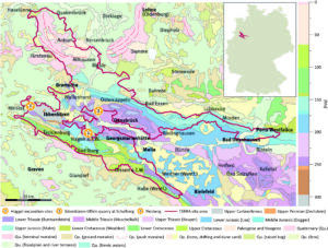
Figure 1. Geological map of the Geopark area 1:1.000.000 showing the location of Hüggel and Schafberg (geological data from Toloczyki et al. 2006). The inset map indicates the location of the UNESCO Global Geopark TERRA.vita in Germany.
Geological setting and paleoenvironment at Hüggel, Schafberg and Piesberg
During the Alpine Orogeny from 95–75 Ma, uplift of Carboniferous to Cretaceous sediments along the Osning Fault Zone within the present-day territory of the Geopark resulted in mountain ranges striking NW-SE, the Teutoburg Forest and the Wiehen Mountains, as well as three single tectonically uplifted areas – Hüggel, Piesberg (both south of Osnabrück) and Schafberg (Ibbenbüren, west of Osnabrück; Geologischer Dienst Nordrhein-Westfalen 2003). These transpressional uplifted elevations with an area of few 10 km² each are located on Hercynian trending axes. They expose the oldest, Carboniferous, strata in the Geopark area and are up to 2,000 m higher than the surrounding Mesozoic strata (Fig. 1; Josten et al. 1984).
Located in the Lower Saxony basin, the sediments at Hüggel, Piesberg, and Schafberg range in age from latest Carboniferous to the Anisian stage of the Middle Triassic (Mittlerer Muschelkalk) and can be accessed in multiple quarries and mining tunnels (Josten et al. 1984; Harms 1995). Because Hüggel has been raised less than Piesberg and Schafberg, it has no exposure to Carboniferous coal seams and claystones, unlike the latter (Josten et al. 1984). The coal seams were deposited in a paralic basin with tropical swamp forests, braided rivers, and lakes with fluctuating water levels (Wrede et al. 2019). The Carboniferous section ends with sandstones intercalated with conglomerates, which were deposited in a subtropical braided river environment (Josten et al. 1984). The Upper Permian Zechstein conglomerate unconformably overlies the sandstones in the quarry sections. This unconformity is the result of a c. 40 Myr long hiatus (equivalent to the Rotliegend), when the Geopark area was located at a continental threshold, i.e., the Hunte sill (Harms 1984, 1995; Geologischer Dienst Nordrhein-Westfalen 2003). Therefore, the transition from Carboniferous sandstones to Upper Permian strata (Zechstein) corresponds to the original paleo-continental surface (Harms 1995; Natur- und Geopark TERRA.vita 2009). The occurrence of the Zechstein conglomerate indicates the transgression of the Zechstein Sea during a phase of subsidence. Furthermore, ventifacts are commonly present in the conglomerate, providing evidence of arid climate for NW Germany during the Late Permian (Harms 1986; Schöllmann 2010).
The Upper Permian section continues with a sequence of bituminous rocks: the dark brownish Mutterflöz limestone beds, the pelitic rocks of the Kupferschiefer, and the dark-grayish Stinkkalk limestones, which have a characteristic smell due to their high content of hydrogen sulfide (Harms 1984, 1995). These bituminous sediments were deposited under oxygen-depleted, deep-water conditions of an inland sea, the Zechstein Sea. Anoxic conditions during deposition of the Kupferschiefer were induced by sills on the seafloor that prevented water circulation in the deeper areas of the basin during a highstand sea-level setting (Haubold & Schaumberg 1985; Paul 2006; Paul et al. 2018). Consequently, the Kupferschiefer is mainly composed of bituminous claystones and marlstones with subordinate mudstones and thin bituminous limestone beds. The name “Kupferschiefer” originates from copper, lead and zinc ores that were mined in Central Germany, e.g., in the Harz Mountains. The metal ores are formed from the high content of hydrogen sulfides in the anoxic sapropels. However, in the Geopark area, the ore content in the Kupferschiefer was too low to be economically viable (Haarmann 1909; Harms 1995). The definition as “Schiefer” (in English: “slate”) is misleading too because the claystones comprising the deposit are not metamorphically altered.
In the regional stratigraphy, the Stinkkalk as well as the overlying Spateisenstein and Zuschlagkalk, the latter being widely known for its centimeter-sized quartz geodes, belong to the Zechstein limestone. The locally occurring Spateisenstein limonite and the Zuschlagkalk dolomite reflect progressively more ventilated, but lagoonal-like conditions. However, the inland sea must have been cut off from the world oceans during the Late Permian, which would explain the deposition of anhydrite and halite evaporites under arid climates (Harms 1995; Natur- und Geopark TERRA.vita 2009). The Lower Werra anhydrites dissolved, and dolines formed over time. During the Oligocene, these dolines collapsed and younger Permian strata such as the Plattiger and Massiger dolomites caved into the anhydrite zone (Harms 1984, 1995). In the quarries at Hüggel, these paleokarst structures are expressed as collapse breccias. The Permian sequence ends with the deposition of cavernous, cross-bedded sandstones indicating a transgression (Harms 1984, 1995). At Hüggel, the Lower and Middle Triassic are characterized by a sequence of reddish clay- and sandstones, the Buntsandsteine, overlain by dolomites and limestones, which represent a braided river environment followed by a sabkha and shallow marine environment under dry climate conditions (Gaertner 1984; Harms 1995; Diedrich 2002, 2008).
Kupferschiefer Fossil Excavations at Hüggel
At Hüggel, the Kupferschiefer can be found in several quarries, where its thickness varies from 32 to 60 cm (Fig. 3A; Harms 1984). It is characterized by good preservation of fish fossils, which was first documented in the first half of the 20th century (Haack 1909, 1935). Remains of typical Kupferschiefer fishes such as Coelacanthus granulatus, Janassa bituminosa, Palaeoniscum freieslebeni, Platysomus gibbosus, Platysomus striatus as well as chopped conifer remains have been described from the Hüggel quarries (Haack 1909, 1935; Harms 1984). These early single finds motivated the local associations Museumsverein Hüggel e.V. and Kultur- und Verkehrsverein Hasbergen e.V. in Hasbergen to organize paleontological excavation campaigns in 2004, 2005, and 2016, which were supported by amateur paleontologists (Fig. 3B; Diedrich 2009; Müller & Haunert 2017). The goal of these campaigns was not only to carry out the first systematic taphonomic and paleoenvironmental studies on the Kupferschiefer fossils in NW Germany, but also to present the newly obtained fossils in a local museum, i.e., the Geocenter Hüggel in Hasbergen, for geoeducational purposes. The Geopark and several social and environmental organizations and local companies supported the initiative financially (Diedrich 2009; Müller & Haunert 2017).
More than 800 fossils were discovered during the three excavation campaigns, of which c. 30 % were fish fossils (Müller & Haunert 2017). Among the latter, Palaeoniscum freieslebeni accounts for c. 90 % (Fig. 2A; Diedrich 2009; Müller & Haunert 2017). Presumably because of its great abundance in all Kupferschiefer deposits, comparable to that of herring in modern oceans, the taxon was given the trivial name “Kupferschiefer-Hering” (“Copper slate herring”). In addition, other ray-finned fishes such as Platysomus striatus, Pygopterus humboldti, Euroysomus macrurus, Dorypterus hoffmanni,and Acentrophorus glaphyrus were also documented (Fig. 2B, 2D; Diedrich 2009; Müller & Haunert 2017). Rare finds of the coelacanth Coelacanthus granulatus and the elasmobranchs Wodnika striatula and Janassa bituminosa complement this typical, but the diverse marine vertebrate assemblage of the Zechstein Sea. Furthermore, it was possible to identify different ontogenetic stages for some of the above-mentioned taxa and assign coprolites to marine vertebrates (Diedrich 2009; Müller & Haunert 2017).
Marine invertebrates are uncommon among Kupferschiefer fossils at Hüggel. Only single finds of pelecypods and brachiopods have been reported (Brandt 2014; Müller & Haunert 2017). The distinctive features of these fossils include compressed nautilids such as Peripetoceras freieslebeni, whose shells are partially preserved as well (Fig. 2C; Diedrich 2009; Müller & Haunert 2017). Although plant remains are very common, they are only represented by conifers such as Ullmannia bronni, Ullmannia frumentaria, Pseudovoltzia liebeana, and Quadrocladus solmsii (Diedrich 2009; Brandt 2014; Müller & Haunert 2017). Apart from coalified branch fragments, cones, and driftwood (Fig. 2C), a single 1.5-m-long conifer stem has been discovered (Diedrich 2009). Furthermore, the sediment shows signs of bioturbation, e.g., thalassinoid burrows (Diedrich 2009; Müller & Haunert 2017).
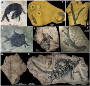
Figure 2. Examples of fossil finds from Hüggel and Schafberg (Schwienheer quarry in Ibbenbüren-Uffeln). A) Palaeoniscum freieslebeni, Hüggel (Photo: Fabian Müller). B) Rock slab with three Palaeoniscum freieslebeni (left) and Pygopterus humboldti (right), Hüggel (Photo: Jannes Bludau). C) Coalified drifted wood (center) and nautilid (top), Hüggel (Photo: Jannes Bludau). D) Platysomus striatus, Hüggel (Photo: Hartwig Wachsmann). E) Menaspis armata, Schafberg (Photo: LWL-Museum für Naturkunde Münster, Berenica Oblonczyk). F) Reticulolepis exsculpta and Platysomus striatus (underlying), Schafberg (Photo: LWL-Museum für Naturkunde Münster, Berenica Oblonczyk). G) Ullmania sp., Schafberg (Photo: LWL-Museum für Naturkunde Münster, Berenica Oblonczyk). H) Protorosaurus speneri, Schafberg (Photo: LWL-Museum für Naturkunde Münster, Berenica Oblonczyk).
Kupferschiefer fossils from Schafberg and Piesberg
Kupferschiefer outcrops can be found not only at Hüggel, but also within the other two transpressional uplifted areas in the Geopark, i.e., Piesberg and Schafberg. Schafberg is located in the western part of the Geopark close to Ibbenbüren. This horst structure is 15 km long and 6 km wide, which makes it the largest of the three elevations. Since Schafberg is in the federal state of North Rhine-Westphalia, it is a subject of the paleontological heritage protection law of this state, whose enforcement is the responsibility of the LWL Museum. The museum’s paleontologists have carried out several excavation campaigns on the Kupferschiefer in the Ibbenbüren-Uffeln quarry. The horizon has an unusually thickness of 250 cm at this location (Fig. 3C–D; Harms 1984, 1986; Schöllmann 2010).
The most prominent and internationally valuable fossil find at Ibbenbüren-Uffeln is the almost complete skeleton of a quadrupedal archosauromorph with a length of c. 1.2 m, the best-preserved specimen of Protorosaurus speneri worldwide (Fig. 2H; Grzegorczyk 2005; Gottmann-Quesada & Sander 2009; Ezcurra et al. 2014). The LWL Museum discovered the fossil during a scientific excavation in 1984 (Friman 1986; Grzegorczyk 2005). Further excavation campaigns were carried out by the LWL Museum between 2005 and 2010, which yielded more than 3000 fossils. In addition to Palaeoniscum freieslebeni, which dominates the fish fossil record by 90 %, several valuable and rare fish fossils such as Platysomus striatus and the predatory ray-finned fish Reticulolepis exsculpta were found at Schafberg (Fig. 2F; Friman 1986; Schultka 1991; Schöllmann 2010). Furthermore, the ventral side of Menaspis armata provides the first evidence of the holocephal chondrichthyan from the region (Fig. 2E; Schöllmann 2010). Coalified drifted wood, branches (Fig. 2G), and fructifications of conifers as well as rare occurrences of invertebrates such as bryozoans complete the fossil record.
The Protorosaurus speneri specimen as well as the entire Ibbenbüren-Uffeln quarry are legally protected as paleontological heritage (Grzegorczyk 2005). Although the fossil-rich Kupferschiefer layers are very close to the surface in the Ibbenbüren-Uffeln quarry, they are not exposed. In order to protect the Kupferschiefer from the acute threat of erosion, it was decided to backfill and reforest the geosite (Grzegorczyk 2005), and the site is only accessible in the course of scientific excavations. The Protorosaurus speneri original, and other fossil finds from the Kupferschiefer at Schafberg are prepared, stored and exhibited at the LWL Museum. Further finds from this location are housed and displayed at the Natural History Museum in Osnabrück (Museum am Schölerberg). At Piesberg, only a few fossil finds such as Palaeoniscum freieslebeni and Reticulolepis exsculpta were reported from the Kupferschiefer deposits (Haarmann 1911; Voigt 1960).
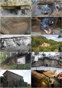
Figure 3. Kupferschiefer excavation sites at Hüggel and Schafberg and geosites along the TERRA.track Geological Educational Trail (TT-GET) at Hüggel. A) Outcrop showing the 35 cm thick Kupferschiefer (bottom) and the overlying Zuschlagkalk (top) at Hüggel (TT-GET station 4; Photo: Tobias Fischer). B) Excavation site at Hüggel in 2016 (close to TT-GET station 6; Photo: Fabian Müller). C–D) Excavation site by the LWL Museum at Schafberg (Schwienheer quarry in Ibbenbüren-Uffeln) in 2009 showing the 2.5 m thick Kupferschiefer and the transgression conglomerate at the excavation bed (Photos: Tobias Fischer). E) The canyon-like quarry Tagebau IIa at Hüggel during its exploitation around 1930. F) The same quarry in 2019 as part of the Geological Educational Trail exposing Zechsteinkalk (TT-GET station 7) and an important element of the EU Habitats Directive area (Photo: Tobias Fischer). G: TERRA.vita panels give information on the geology along the Geological Educational Trail, in this case on the Rotliegend unconformity (TT-GET station 11; Photo: Rahel Nicolaus). H) Mining historical relics such as the Kielmannsegge Shaft also represent important stations along the trail (TT-GET station 8; Photo: Natur- und Geopark TERRA.vita). I) The Augusta Shaft, the former pump station of the ironwork built in 1876, is presently a memorial to remember the crimes committed by the Nazi regime during World War II (Photo: Tobias Fischer). J) The Silverlake Gallery exposes Middle Triassic trace fossils and can be entered by visitors during guided tours (TT-GET stations 15–16; Photo: Hartwig Wachsmann).
The Geological Educational Trail at Hüggel
The Hüggel area is punctuated with numerous gorge- or canyon-like quarries and tunnels (Fig. 3E–J). This high density of abandoned mining areas is the result of the centuries-long mining tradition in the region. The extraction of silver-bearing, non-ferrous metals began as early as 1180 (Harms 1995). Surface mining portals and surface trenches (“Pingen”), e.g., on the Silberberg close to Hüggel, left after mining activity during the Middle Ages, remain preserved today and are partly protected as natural monuments (Fischer 2020). Industrial mining began at Hüggel in 1836 with the foundation of the ironwork Beckeroder Eisenhütte (Harms 1995). From that point on, not only iron ore, but also limestone, which was used for the smelting of iron ore, were mined in quarries and mines of Hüggel. Under the direction of the association Georgs-Marien-Bergwerks- und Hüttenverein, which took over the ironwork and mining areas in 1856, underground and surface mining continued until 1940 and 1963, respectively (Harms 1995). However, the production of steel by the Georgsmarienhütte GmbH has remained in the region until now.
Due to the numerous geosites, historical mining buildings and other mining relics, some of which are protected as natural or industrial monuments, Horst Klassen, geologist from the Natural History Museum in Osnabrück, suggested a geological loop trail in the Hüggel area (Harms 1995). The Municipality of Hasbergen opened the Geological Educational Trail in 1980, while the Geopark (at that time called “Nature Park Nördlicher Teutoburger Wald/Wiehengebirge e.V.”) and the County of Osnabrück provided financial support and infrastructure to access the geosites (Harms 1995). Furthermore, geologist Franz-Jürgen Harms developed a guidebook for the Hüggel Geological Educational Trail, which was published in 1980 and, as a second edition, in 1995 (Harms 1980, 1995). In 2001 and 2008, the Geopark revised the geological loop trail and its information panels, which were produced using the TERRA.vita design (Fig. 3G-H; Natur- und Geopark TERRA.vita 2009). The guidebook was reissued by the Geopark with financial support from the Hasbergen Municipality, the foundation Sparkassenstiftung Osnabrück, and the Niedersächsische Bingo-Umweltstiftung in 2009 (Natur- und Geopark TERRA.vita 2009). The geological loop trail received its current name, TERRA.track Geological Educational Trail, and was signposted with guideposts, colored markings on trees and road signs using the TERRA.vita corporate design in 2019. Since then, it has become part of the Geopark’s hiking network TERRA.tracks (Fischer 2020).
The TERRA.track Geological Educational Trail is divided into two parts – a 6-km-long main track and a 3-km-long, almost obstacle-free alternative (Fig. 4). The track leads along or through at least ten quarries and gives information on the surrounding rocks and soils, the Earth history and tectonic genesis of Hüggel as well as the local mining history at 22 information stations and a TERRA.vista audio play station (Natur- und Geopark TERRA.vita 2009; Fischer 2020). The northern part of the short hiking track alternative leads partly along the former Hüggel mining railway, which was built in 1864–66, but was already dismantled in 1895 (Harms 1995). The stations also include the Kupferschiefer excavation site from 2016 and some other outcrops of the bituminous sediments (Müller & Haunert 2017; Fischer 2020). Two highlights of national importance in the Hüggel area are the industrial monument Augusta Shaft and the natural monument Silverlake Gallery (Fig. 3I-J; Fischer 2020). The Augusta Shaft is a former pump station of the ironworks, which was built in 1876. During World War II, the building was used as a prisoner camp, a forced labor camp, and a “work education camp” (“Arbeitserziehungslager”). In 1998, the local association Verein Initiative Augustaschacht started re-establishing the building as a memorial to remind visitors of the crimes committed during the Nazi era. The Silverlake Gallery is a visitor mine at the bottom of an inactive quarry, in which trace fossils of the Middle Triassic Sea are exposed (Diedrich 2010). Regular tours into the mine and along the Geological Educational Trail are assisted by the Geopark’s nature guides, so-called TERRA.guides. The local association Kultur- und Verkehrsverein Hasbergen e.V. also offers guided tours along the track and maintains its infrastructure.
The gorge-like quarries at Hüggel presently provide excellent microhabitats for rare plants such as hart's-tongue fern (Asplenium scolopendrium), the liana common honeysuckle (Lonicera periclymenum), orchid meadows, and calaminarian grasslands (Fig. 3F). The quarry lakes and ponds are inhabited by northern crested newts (Triturus cristatus), while the tunnels serve as roosts for rare bats such as Bechstein’s bat (Myotis bechsteinii), greater mouse-eared bat (Myotis myotis), and pond bat (Myotis dasycneme). Due to its significant ecological importance, the Hüggel area is protected under the Habitats Directive of the EU (Fischer 2020).
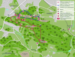
Figure 4. Map of the Hüggel area showing the TERRA.track Geological Educational Trail and the TERRA.vita information stations.
New Geocenter Hasbergen at Hüggel: An Outlook
The local museum association Museumsverein Hüggel e.V. ensures proper storage and presentation of the Kupferschiefer fossils that were recovered during past excavation campaigns at Hüggel. Fossils were exhibited at the Geocenter in Hasbergen from 2004 to 2018, close to the locations where they were found. Elevated moisture in the building means that the Geocenter was recently relocated to the Mining Museum Ibbenbüren at Schafberg. However, the latter had to close in 2020 to pave the way for a successor. Therefore, from 2021 onwards, the Kupferschiefer fossils will only be shown to the public as part of a special exhibition at the Natural History Museum in Osnabrück, which provides a short-term solution to the problem. In the long term, the Municipality of Hasbergen, the Geopark, and the museum association are planning to establish a new, small Geocenter in Hasbergen. The purpose of the future museum would be not only to keep the fossils close to their excavation sites, but also to strengthen the identity and supra-regional public recognition of the Municipality of Hasbergen. Furthermore, the Geocenter has been an important learning facility for school classes during its operation in Hasbergen. Therefore, the future Geocenter should be designed to educate school children and other visitors about the unique geology and mining history of Hüggel as well as its importance as a natural reserve. Furthermore, it is crucial that the Geocenter can raise public awareness of how much the geologic setting and the climate have changed in the course of Earth’s history, while showing the connection between the past and the present climate changes.
Conclusions
The Kupferschiefer fossils found in the UNESCO Global Geopark TERRA.vita are considered of international importance because they extend the Zechstein Sea fossil record to northwestern Germany and greatly contribute to the knowledge of Late Permian fishes and reptiles. Alongside numerous unique geological highlights in the Geopark area, the Kupferschiefer played a vital role in its becoming a UNESCO Global Geopark in 2015. Specifically, Hüggel and Schafberg are characterized by valuable assemblages of Kupferschiefer fossils and by an exceptionally high geodiversity. The long stratigraphic record, from Late Carboniferous to Middle Triassic within a small geographic area, means visitors have an opportunity to learn about a diversity of rock types (i.e., Carboniferous sandstone and conglomerates, pelitic Kupferschiefer rocks, Zechstein limonites and dolomites, Triassic limestones) and tectonic phenomena (i.e., Rotliegend unconformity, Alpine Orogeny, reverse and strike-slip mechanisms, paleokarst). Moreover, the region features numerous highlights related to its centuries-long and diversified mining history. All these aspects make the TERRA.track Geological Educational Trail at Hüggel with its wide range of guided tours offered by the Geopark and local associations as well as the Natural History Museums in Münster and Osnabrück crucial for geotourism and geoeducation in this region. The current situation with the fossil collection from Hüggel (Museumsverein Hüggel e.V.), which cannot be presented to the public and is not fully accessible to scientists, remains challenging. Establishing a new Geocenter to host this collection will not only provide an access to the fossils, but also allow strengthening the supra-regional public recognition and identity of the Municipality of Hasbergen.
Acknowledgments
The Municipalities of Hasbergen and Hagen a.T.W., the Nature Conservation Agency of Osnabrück County, and the members of the Kultur- und Verkehrsverein Hasbergen e.V., Museumsverein Hüggel e.V., and the Mining Museum Ibbenbüren are thanked for their years of support in preserving the geoheritage of Hüggel and in maintaining the Geological Educational Trail. The authors thank the photographers mentioned in the figure captions for providing photographs. Polina Vakhrameeva, Heidelberg University, is thanked for technical discussions.
Conflict of Interest
The authors declare that there is no conflict of interest in their work.