Introduction
The English Riviera UNESCO Global Geopark sits within the Variscan Orogenic Belt (Leveridge and Shail 2011a, figs 2, 3), which extends across South-West England from west to east and includes most of the County of Devon west and south of Exeter (Fig. 1).
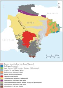
Figure 1. Geological map of Devon, based on published data of the British Geological Survey.
The rocks of the Geopark were deposited within the South Devon Basin (Selwood et al. 1984; Selwood 1990; Leveridge et al. 2003a, b; Leveridge and Shail 2011a, figs 2, 3) of the Rheno-Hercynian Zone of the European Variscides. The South Devon Basin is separated into two parts, with the ‘Torquay High’ forming the boundary. To the south, between the South Devon Basin and the Looe Basin is the ‘Brixham (or Plymouth) High’ (Leveridge et al. 2003a; Leveridge 2011, fig. 4). Within the Devonian succession, located on these E–W trending highs, are a series of Middle Devonian limestones, extending from Plymouth, to Yealmpton, Newton Abbot and Torquay (Worth 1874). Most of these limestones are fossiliferous, with rich assemblages of corals, stromatoporoids (extinct sponge-like organisms), brachiopods (Pengelly 1867a), gastropods, bivalves, trilobites, bryozoans and crinoids. These coral-rich limestones of South Devon – especially in the Torquay area – were key to the creation of the Devonian System as we know it today. As early as the 1830s, William Lonsdale had shown that the corals and other shelly fossils in these limestones were intermediate between those of the Silurian and Carboniferous (see De La Beche 1829; Lonsdale 1840a, b; Phillips 1841; Tasch 1950). In North Devon, Henry De La Beche had also suggested that plant macrofossils appeared to be earlier in character than those known from the Carboniferous.
In 1834, there arose the ‘Great Devonian Controversy’ with, on the one hand, Roderick Impey Murchison and Adam Sedgwick and, on the other Henry De La Beche and George Bellas Greenhough (Rudwick 1986, 1988). In 1839, Henry De La Beche published his ‘tour de force’ Report on the Geology of Cornwall, Devon and West Somerset. In the same year, Sedgwick and Murchison (1839) presented their evidence for a new system, the Devonian, which was followed in 1840 by the official proposal for the Devonian System, with the shelly fossils of the Torquay area important in its definition. The geological localities described here are, therefore, of historical – as well as palaeontological – significance in the creation of the Devonian as an important component of the Geological Time Scale (Gradstein et al. 2012; 2020).
Dineley (1961) was one of the first to describe these Torquay limestones as being ‘reefal’ in origin and his concepts were extended by Scrutton (1965, 1967, 1968; 1977a, b) in his seminal work on the Devonian limestones of the area. Scrutton (1977a, b) described these coral-rich limestones as the Tor Bay Reef-Complex and his models were revisited by Leveridge and Shail, (2011a, fig. 5) in the Geological Conservation Review (GCR) volume. All the reconstructions of these reefs generally show a ‘core’ of stromatoporoid/coral limestone, with a back-reef area of massive, relatively un-fossiliferous limestones and fore-reef debris flows (rudstones) of broken corals and stromatoporoids passing into what are interpreted as deeper-water siltstones and mudstones. In the early discussions of these coral-rich assemblages, there was little recognition of the palaeogeography of the time, but as can be seen in various reconstructions (e.g., Hart 2012, fig. 2), these Devonian rocks were deposited around 10°S of the Equator, and well within the normal distribution of corals in tropical locations. In the subsequent 350 million years, Torquay has migrated – by means of Continental Drift and Plate Tectonics – to the present location 52°N of the Equator (Hart 2012, fig. 2).
The stratigraphy (Leveridge et al. 2003a, b; Leveridge and Shail 2011a, fig. 9) of these mid-Devonian, ‘reefal’ successions relies on a great deal of detailed palaeontological research using ammonoids (House 1963; Becker and House 2000; House and Gradstein 2004), ostracods (Ussher 1907; Gooday 1978; Gooday and Becker 1979), conodonts (Kirchgasser 1970; Sadler 1973a,b; Orchard 1978; Castle 1982; Higgins and Austin 1985; Ziegler and Sandberg 1990; Klapper 2000) and miospores (McGregor 1979; Streel et al. 2000).
Location
The English Riviera UNESCO Global Geopark is located on the eastern coastline of South Devon (Figs 1, 2). The boundary of the Geopark territory is that of the Torbay Unitary Authority and, as such, follows no geological or physical features. While the coastline provides the obvious access to the geological features, there are many inland quarries which are, unfortunately, either overgrown, built over, or infilled. In a few locations, there are exposures in roadside cuttings.
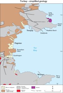
Figure 2. Simplified geological map of the English Riviera UNESCO Global Geopark with key locations identified.
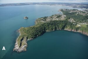
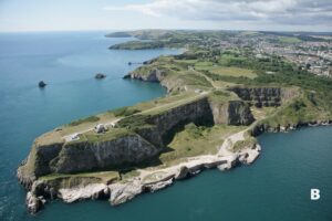
Figure 3. A) Ariel view of Hopes Nose looking towards the south. B) Ariel view of Berry Head looking towards the south. The extensively quarried north face of this headland can be seen clearly as the operations to remove building stone only ended in the 1960s. Images provided by the English Riviera UNESCO Global Geopark.
The marine area of Tor Bay is enclosed between two, prominent headlands; Hope’s Nose in the north and Berry Head in the south (Fig. 3A, B). These headlands, which represent the limestones of the ‘Torquay High’ and the ‘Brixham High’, are composed of resistant Devonian rocks, while the intervening area (forming the ‘bay’) is formed mainly of softer, Permian sandstones, conglomerates and breccias (see Hart and Smart, this volume).
Key Features
Palaeozoic reefal limestones contain tabulate and rugose corals as well as other invertebrate fossils. They are, therefore, quite different from modern, scleractinian-dominated, reef systems and the structures seen in the Palaeozoic are not the massive features recorded in the Great Barrier Reef or similar tropical and sub-tropical locations. The other characteristic feature is the presence of stromatoporoids. These are an extinct group of calcified ‘sponges’ which grow as a series of domal structures that also have very fine, concentric, internal growth features. There is no evidence of polyp-like growths and they often encrust other fossils. In some places they appear to use the tabulate coral, Syringopora, as a framework on which to develop and which may be evidence of a commensal relationship. In the English Riviera UNESCO Global Geopark there are several locations in which these coral-rich, stromatoporoid limestones can be studied and some of these are discussed below.
Meadfoot Beach and Daddyhole
Meadfoot Beach (UK Grid Reference, SX 9305 6311 to SX 9370 6327) forms the north shore of Tor Bay to the east of Torquay town centre (Fig. 4A). The rocky foreshore, which is accessible at low tide, extends from the promenade at the western end of the beach, eastwards towards the Ilsham Valley and the cliffs below the prominent block of Kilmorie Flats. This is the type locality of the Meadfoot Beds (Champernowne 1874, 1881; Ussher 1890; Simpson 1959). In one of the earliest descriptions of the succession, Pengelly (1867a) recorded the presence of fish scales and identified them as Phyllolepis concentricum (Agassiz) of the Lower Devonian. The Meadfoot Group, as they are now known (Ussher 1907), are interbedded dark-grey silty mudstones and fine-grained sandstones (Table 1).
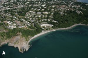
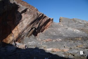
Figure 4. A) Ariel view of Meadfoot Beach, with Triangle Point at the end of the promenade on the left. Image provided by English Riviera UNESCO Global Geopark. B) Triangle Point with mineralized fault on the left and the prominent bedding surface of Triangle Point on the right.
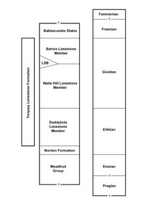
Table 1. Simplified stratigraphy of the Devonian rocks of the ‘Torquay High’, showing the lithostratigraphy and approximate correlation with the standard Devonian Stages.
There are occasional beds and lenses of fossiliferous calcareous sandstone (Richter 1967; Leveridge 2011, pp. 672–674). Many of the mudstones in the Meadfoot Group are bioturbated by Chondrites-style burrows, while Richter (1967) records the presence of Spirophyton. Shelly fossils include brachiopods (especially spiriferids), bivalves, and trilobites (mainly homalanotids), with fewer records of gastropods, crinoids and corals (which appear to have been transported into the mudstones as they are usually damaged).
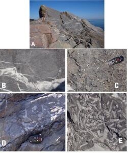
Figure 5. Images of the Triangle Point area. A) Large, prominernt bedding plane. B) Syringopora/stromatoporoid intergrowth. C) Assemblage of turreted gastropods. D, E) Thin, dark-coloured rudstone beds with disorganized and broken corals and stromatoporoids.
The headland at the western end of Meadfoot Beach is known as Triangle Point (Fig. 4A) and provides an outcrop of the Daddyhole Member of the Torquay Limestone Formation (Leveridge 2011, pp. 674–677). Within the old quarry, are some important features, including a major fault plane (with mineralized slickensides) that extends E–W along the base of the cliffs (Fig. 4B). On the floor of the quarry are a significant number of in-situ coral mounds that demonstrate that these Devonian coral reefs are not the same as modern scleractinian corals (Scrutton 1977b, p. 169). They are not major structures, being a collection of small, separated, coral mounds with reef debris forming the limestones between the individual corals; mainly Mesophyllum, Acanthophyllum, Calceola, Thamnopora and Alveolites. Within the overlying succession are a series of dark-coloured rudstones that contain reefal debris (Fig. 5D, E) and which represent debris flows from the higher parts of the reef. Interbedded with these are a series of limestones that contain large numbers of brachiopods or turreted gastropods (Fig. 5C). The prominent, well-exposed bedding plane (Fig. 5A) contains many small (Syringopora (Fig. 5B) most examples of which have small diameter corallites. The intervening limestones contain abundant examples of the tabulate coral Aulopora and brachiopods, some of which show geopetal structures. Goldring (1978, fig. 35) provided a model of these stromatoporoid assemblages and this is reproduced as Figure 6.
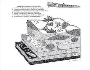
Figure 6. Palaeoecological model of off-reef area showing the presence of stromatoporoids and stag’s horn corals. After Goldring (1978, fig. 35).
The upper part of the Daddyhole Limestone Member is exposed in the inaccessible Dyer’s Quarry (SX 9223 6277) where many of the coral ‘thickets’ are in life position. These include a diverse assemblage of Thamnophyllum, Mesophyllum, Acanthophyllum, Alveolites and Heliolites; see Scrutton (1965, pp.186–188). The lower part of the section seems to have been deposited in quiet conditions but there is evidence for current activity higher in the succession. There are a few tuffs in the succession including at least one prominent bed that can be seen ‘smothering’ some of the in-situ corals.
Between the Daddyhole Limestone Member and the overlying Walls Hill Limestone Member are a series of thin-bedded limestones that can be seen at Redgate Beach, as well as in a road cutting on Babbacombe Road near the site of the now-demolished Palace Hotel (SX 9319 6478). The Walls Hill Limestone Member is best exposed between Withy Point (SX 9316 6550) and Long Quarry Point (Fig. 7). The Walls Hill Limestone is a massive, pale-grey, white-weathering limestone with a fauna dominated by stromatoporoids. At Long Quarry Point, Kershaw and Riding (1980) described a variety of stromatoporoid shapes and structures, including laminar, domical, bulbous, and dendroid. They also introduced the terms ‘smooth’ and ‘ragged’ to describe the overall appearance of the coenostea. Following a quite detailed morphometric analysis, Kershaw and Riding (1980) suggested that the lower part of the succession was dominated by laminar and domical forms that comprised 25% of the rock mass and probably represented a reefal facies. The upper 100 m of the succession, with mainly domical and bulbous forms making up 10–15 % of the rock mass, they interpreted as representing a transition to a back-reef facies. This style of analysis has recently been extended by Da Silva et al. (2010). While this type of morphological analysis is extremely useful in the determination of reefal associations and palaeoecology, one must always remember that these particular limestones – and their enclosed fossils – have been deformed by the Variscan Orogeny and allowance must be made for any shape changes introduced by the tectonics.
The boundary (Table 1) between the Walls Hill Limestone Member and the overlying Barton Limestone Member was previously exposed in Lummaton Quarry and is described in a following section.
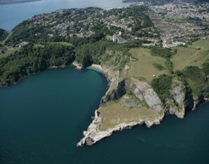
Figure 7. Aerial view of Long Quarry Point showing the area occupied by the former quarry and the white appearance of the Walls Hill Limestone Formation. Image courtesy of the English Riviera UNESCO Global Geopark.
Hope’s Nose
Hope’s Nose National Nature Reserve (NNR) is accessed from Ilsham Marine Drive at the eastern extremity of the Torquay Peninsula (SX 948 635). The Hope’s Nose NNR (Leveridge, 2011, pp. 677–680) includes a number of faulted blocks of Lower and Middle Devonian strata and while some of the boundaries can be seen most are covered in vegetation (Fig. 3A). The Middle Devonian limestones are seen best in two locations; 1) below the raised beach at the southern end of the headland, and 2) in the old quarry at the northern extremity of the headland. In the sea cliffs below the famous raised beach the thinly bedded limestones of the Daddyhole Limestone Member (Torquay Limestone Formation) are folded and show exceptionally good bedding/cleavage relationships. Inter-bedded with the limestones is a small number of graded, water-laid, ash-fall beds up to 12–15 cm thick (Fig. 8A, B). In the inaccessible Dyer’s Quarry, near Torquay Harbour, comparable ash-fall beds are seen burying in-situ corals.
At the northern end of the Hope’s Nose peninsula, the old quarry is usually accessible and is one of the best locations in which to see beds of stromatoporoid/coral limestones (Fig. 8C-E). Some of the top surfaces of bedding planes show the irregular, bun-shaped stromatoporoids up to 65 cm in diameter, many of which are definitely disturbed and disorientated. Corals are both diverse and abundant, including Mesophyllum, Acanthophyllum, Cyathophyllum, Heliolites, Alveolites and Thamnopora. In a lengthy discussion, Scrutton (1977b, pp. 170–171) explains the correlation of the Hope’s Nose, Triangle Point and Dyer’s Quarry successions. One of the key issues is the nature of the unconformity/discontinuity between the more massive limestones on Hope’s Nose and a succession of thin-bedded limestones; see also Braithwaite (1967, p. 299).
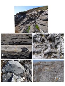
Figure 8. Images of Hope’s Nose. A) General view of section showing the thinly-bedded limestones, ash-fall deposits and the overlying raised beach. B) Close-up of the major ash-fall horizon showing the graded bedding. C) Thamnopora coralites. D-E) Foreshore outcrops of old quarry faces with stromatoporoids, including (D) Details of the internal laminations.
Lummaton Quarry
This old quarry ceased operation many years’ ago and has degraded quite badly over time (Fig. 9A, B). The floor of the old quarry is also an industrial estate that governs access to the site. The Lummaton Shell Beds (Leveridge 2011, pp. 682–684) were an important part of the creation of the Devonian System and, while this location remains an important SSSI, its geological value has been much reduced by access problems. The quarry is within a fault-bounded block and is located in the north of Torquay (Leveridge et al. 2003b; Leveridge 2011, fig. 44). The fossil locality, in what is now known as the Lummaton Shell Beds, lies at the boundary of the Walls Hill Limestone Member and the Barton Limestone Member of the Torquay Limestone Formation (Table 1). The fossil rich horizon was made famous by the monograph of Whidborne (1888–1907) while Ussher (1905) listed the fauna known at that time, indicating that 220 species were present. Ussher (1903) thought that the fauna was late Givetian in age, but the presence of Phillipsastrea (hennahi) hennahi Lonsdale, was thought to place it close to the Givetian/Frasnian boundary (Jukes-Browne 1906, 1913; Lloyd 1933). Subsequent work on the conodonts (Matthews 1970; Kirchgasser 1970; Orchard 1978; Castle 1982; Higgins and Austin, 1985) places it within the late early to mid-Givetian interval. The shell beds contain trilobites (Selwood 1966), ammonoids (House 1963), gastropods, bivalves, brachiopods (Elliott 1961), crinoids, ostracods (Gooday 1978), bryozoans, corals (Scrutton 1977b), stromatoporoids – including Actinostroma sp. cf. A. stellulatum Nicholson and Stromatopora concentrica Goldfuss (Jukes-Browne 1906) and miospores (Streel et al. 2000).
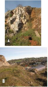
Figure 9. A, B) Lummaton Quarry in NW Torquay, showing the limestone faces and the generally built-up appearance of the old quarries. Images courtesy of English Riviera UNESCO Global Geopark.
Lummaton was one of the last of the working quarries to close in the Torquay area and it is possible that the outer wall of the Ascot House Hotel (Tor Church Road, TQ2 5UR) garden is constructed of blocks from that quarry (Fig. 10A-F). The limestones used in the stonework are certainly quite fresh and the range of fossils visible in the blocks looks typical of that associated with Lummaton Quarry. It is impossible, however, to be completely certain that the blocks are from Lummaton as many buildings in Torquay have re-used stone over the years and without the builder’s papers showing the direct source of the stone that was used, it can only be regarded as a possibility.
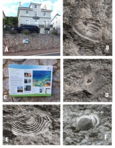
Figure 10. Ascot House Hotel, Torquay. A) General view of the hotel and the wall alongside Tor Church Road. B) Geopark information board. C) Brachiopod; D-F) Trilobite fragments; E) fenestellid bryozoan. Images C-F provided by Ms Melanie Border, English Riviera UNESCO Global Geopark.
Saltern Cove
Saltern Cove (SX 8952 5842) is a famous location, immediately south of Goodrington on the western shore of Tor Bay. Between here and Shell Cove (SX 8964 5814) are exposures of the Brixham–Goodrington limestone succession which are overlain by thin-bedded limestones and slates of Frasnian age (Anniss 1927; Lloyd 1933, pp. 86–90; House 1963; Scrutton 1968, p. 189; van Straaten and Tucker, 1972; Scrutton 1977b, pp. 174–175; Leveridge 2011, pp. 668–672). While the tin-bedded limestones contain coral assemblages (e.g., Peneckiella, Disphyllum, Tabulophyllum and some tabulate species) most appear to be reworked and derived from nearby carbonate factories that were probably in shallower water. The importance of this location is enhanced by the presence of a ‘Goniatite Bed’ within a 5 m thick matrix-supported breccia. Holwill (1966), on the evidence of the coral assemblages, suggested that the blocks were of Givetian or early Frasnian age, while conodonts suggested slightly younger ages (Frasnian and early Fammenian). The assemblage of important Frasnian goniatites is, therefore, somewhat anomalous and suggestive of re-deposition (Leveridge 2011, p. 671–672).
Berry Head
Berry Head NNR (SX 9475 5655) is not only designated for its geology, but for the marine and terrestrial faunas and – especially – the flora, which is typical of calcareous soils (Smith et al. 2016). The shape of the headland (Fig. 3B) is the result of major quarrying activity on the northern side which only ended in the 1960s. The Berry Head Limestone, which is the thickest development of limestone in the area formed in the carbonate factory on the Brixham High (Leveridge, 2011, Fig. 4B). Dineley (1961) described it as a ‘classic’ reef model, with a stromatoporoid/coral core, flanked by fore-reef and back-reef sediments. Braithwaite (1967) was not totally convinced, describing the carbonate petrography of the limestone successions in detail. The Berry Head Limestone is less fossiliferous than those around Torquay, and the old quarry is best known for the Permian fissure fillings (Fig. 11) that characterize the faces and foreshore areas nearby (Pengelly 1866; Richter 1966, 1968; Hart and Gosling 2018; Hardman et al. 2020). Initially thought to be ‘Neptunian Dykes’, they are not simple examples of sediment falling, or being washed, into fissures in the limestone. There is evidence of multi-stage opening, with mineralization of the walls, in response to NNW–SSE extension as suggested by Shail and Leveridge (2009) during initial rifting of the Portland-Isle of Wight Basin. Hardman et al. (2020, fig. 14) demonstrate that they are fault-related openings that formed within a few hundred metres of the palaeo-surface and that there is very little, if any, evidence of solution or karstification. Calcite crystals are often seen at right-angles to the fissure walls, and there is much evidence of multiple movements and fissure opening. The headland is also characterised by cave systems that are close to sea level and which contain Pleistocene sediments from Marine Isotope Stages 5, 7 and perhaps earlier (Proctor 1988, 1996, 2018; Proctor and Smart 1991; Straw 1996; Hart et al. 2019).
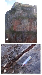
Figure 11. Berry Head fissure fillings. A) General view of north face below the ramparts of a Napoleonic Fort, showing mineralization at margins of the fissures. B) Close-up of a small fissure showing mineralization.
Geotourism
Many of the important geosites within the English Riviera UNESCO Global Geopark, are either:
- Geologically quite complex and require a level of geological understanding above that of general visitors. This makes their interpretation quite challenging; and
- Difficult to access and, therefore, quite restricted in terms of availability to both scientists and visitors.
Visitors are, therefore, often directed towards locations with a variety of interests (e.g., Berry Head [Fig. 3B] with its views, sea birds, dolphins and limestone-loving vegetation, as well as important archaeological remains). Hope’s Nose (Fig. 3A) is a National Nature Reserve that provides an energetic walk down to the raised beach, dramatic folds, coral/stromatoporoid rich limestones and views of the Ore Stone with its northward-facing, overturned fold. Visitors may also learn about the Middle Devonian limestones, cave exploration, Stone Age tools, vertebrate fossils and hominin fossils by visiting Kents Cavern (Pengelly, 1864, 1865, 1867b, 1868a, b, c, 1869a, b, 1871, 1875, 1878, 1884a, b; Vatchell 1953; Stringer 2006; Lundberg and McFarlane 2008; Proctor 2018, and references therein).
Within Kents Cavern are a range of cave deposits including breccias, cave earths and stalagmite floors. The scientific excavation of the caves was begun by William Pengelly (Warren and Rose 1994) on the 17th March 1865. With the approval of the cave’s owner, and financial support from the British Association, Pengelly began a 15-year excavation of the caves during which time more than 80,000 different objects were collected and catalogued (Lundberg and McFarlane 2008; Powe 2008). Pengelly was, however, not the first to investigate the caves as this had begun in 1825. Father John MacEnery came to Torquay from Ireland in 1822, having been appointed as Chaplain to the Carey family at their home in Torre Abbey. Father MacEnery developed an interest in archaeology and, despite being a Roman Catholic priest, began to excavate the caves between 1825 and 1829 (MacEnery 1859). With the bones of cave bears, hyenas, cave lion, bison, woolly rhinoceros, mammoth and scimitar cats he found flint tools that indicated the possible presence of ‘early’ hominins in the caves. The recognition that hominins had sheltered in the caves alongside now-extinct animals must have been a challenge to this young priest’s faith as it clearly pointed to an antiquity of man well beyond the biblical account (Pengelly 1867b, 1868a, b, 1875, 1884b).
William Pengelly and his team from the newly established Torquay Natural History Society made meticulous notes, all preserved in Torquay Museum as a series of diaries (Pengelly 1865–1880, Archives) and ‘exploration journals’ (Torquay Museum, www.torquaymuseum.org – see collections/archives). Pengelly devised a 3-D method of graphical recording that is, essentially, the way modern cave research is undertaken. Pengelly reported many of his findings in the early volumes of the Devonshire Association and elsewhere (Pengelly 1869–1884, Archives). In the 128 years of post-Pengelly research, there is now a record of ~500,000 years of intermittent hominin occupation (MacFarlane and Lundberg 2005; Lundberg and McFarlane 2008). The earliest evidence of this occupation is in the form of Acheulian cultural artefacts that are indicative of pre-Neanderthal Homo (perhaps close to Homo heidelbergensis). These are recorded in Marine Isotope Stages 15–11 (Cromerian Interglacial Complex). The record of hominin occupation is clearly related to climate as there is strong evidence from all over the U.K. that during glaciations, when even South Devon would have suffered harsh peri-glacial conditions, these early hominins migrated away from the area. During interglacial conditions, they were able to migrate north again, although it would have been an interesting balance between the warming climate and the rising sea level that would have separated the British Isles from the rest of Europe. In Marine Isotope Stages (MIS) 11–10 (~430,000–340,000 years before present) there are no known artefacts in the region and one must assume that this is either collection failure or a genuine lack of hominins. During the Ipswichian Interglacial (MIS 5) hominins were again present and in the warmer climate of MIS 5.5 (~125,000 years before present) sea levels were higher than those of day: evidence for this coming from the raised beach preserved on Hope’s Nose (Fig. 8A). In the subsequent Devensian Glacial Stage (MIS 4–2) there was severe frost impact on Kents Cavern with calcite layers being shattered and solifluction of cave earths. In these deposits the ‘Kents Cavern jaw’ was discovered. Dating this hominin maxilla has proved difficult and not without some controversy. Found in 1927, this upper jawbone was dated at ~31,000 years before present and tested to see if it could be Neanderthal in origin. More recently (in 2011) it has been re-investigated (Higham et al. 2011; Mellars 2011) and the date revised to 44,200–41,500 years before present, making it the oldest modern human fossil in north-western Europe. It also confirms that modern humans co-existed with Neanderthals at that time. Research on Kents Cavern, along with other caves in South Devon, continues and there is a growing body of literature on the results of these investigations (e.g., Benyon et al. 1929; Smith 1940; Kennard 1945; Vatchell 1953; Rogers 1956; MacFadyen 1970; Campbell and Sampson 1971; Straw 1983, 1996; Silvester 1986; Lister 1987; Proctor and Smart 1989; Proctor 1996; Campbell et al. 1998; Leveridge et al. 2003a, b; Stringer 2006; White and Pettitt 2009; Chandler et al. 2010).
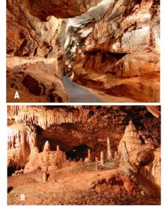
Figure 12. Kents Cavern showing two of the areas covered by tourist excursions to the cave system including A) The long gallery and B) The ‘Wedding Cake’. Images provided by Nick Powe, Kents Cavern.
To most visitors, however, Kents Cavern is a ‘show cave’ and open to the public (Fig. 12A, B). The first visitors arrived in 1880 (Powe 2008) and, since that time, over 6 million people have been through parts of the cave system. Visitors include the future King George V (in 1879), Beatrix Potter (1893) and the exiled Emperor Haile Selassie (1937). Agatha Christie (who lived in Torbay) referred to the caves in one of her novels (“The man in the brown suit”, written in 1924). In 1952, Kents Cavern was designated as a Site of Special Scientific Interest (SSSI) and placed under legal protection. Many of the specimens from Kents Cavern, as well as Pengelly’s notebooks and diaries, are housed in the Torquay Museum (see Hart 2012; Proctor 2018). Also in Torquay Museum is a table constructed of Torquay Marble (Fig. 13). In the 18th to 20th centuries, there was a major stone industry in Torbay and many of the coastal sites, such as Berry Head, Dyer’s Quarry, Long Quarry Point and Petitor, were extensively quarried along with a complete range of inland locations. Some of the more decorative limestones were polished and used in a range of local buildings as well as others in the region and in London (Walkden 2015). They were traded under the name of Torquay (or Torbay) Marble, though they are not true marbles.
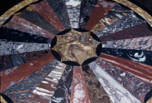
Figure 13. Ornamental table in Torquay Museum which was created to showcase the various types of Torquay Marble.
Many of the churches, public buildings and former banks in the Torquay, Paignton and Brixham area are constructed of the local limestones and, along with many of the sea walls (e.g., Meadfoot Beach, Torre Abbey Sands, Goodrington, etc.) can be inspected – safely – for their fossil content (Fig. 14).
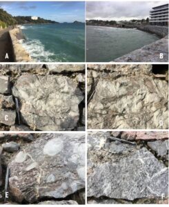
Figure 14. Promenade walls in A) Meadfoot Beach (with Kilmorie Flats, Ore Stone [flat top] and Thatcher Rock [pointed top] in the distance, B) Adjacent to Torre Abbey Sands. Inspection of these blocks of the Torquay Limestone Formation allow the identification of both the coral assemblages (tabulate and rugose) and the stromatoporoids (Fig. 14C-F). Note the 13 cm long pen for scale.
Geosites that may, potentially, be used for pre-university education are also quite limited on grounds of safety but are described on-line in the Devon Register of Educational Sites.
Conservation
Many of the geological sites, of which there are 32, within the English Riviera UNESCO Global Geopark are recognized as being of national importance (www.englishriviera geopark.org.uk). Beginning in the mid-1970s, the Nature Conservancy Council (NCC) began a program of assessment and documentation of important geological and geomorphological sites in Great Britain (Ellis 2008, 2011). The Geological Conservation Review (GCR) as it became known, was formally launched in 1997 and was a world first in terms of geoconservation. By 1990, ~3000 sites were on the GCR Register, and the majority of these have now been designated as Sites of Special Scientific Interest (SSSI) by English Nature and, later, by Natural England. The GCR sites have been summarised in a series of 36 thematic books published by the NCC and the Joint Nature Conservation Committee (JNCC); see Ellis et al. (1996). It was planned that there should eventually be 45 volumes and, from 2010, the publication has been undertaken by the Geologists’ Association in its journal (Proceedings of the Geologists’ Association). The first volume to be published, on ‘The Marine Devonian of Great Britain’ (B.E. Leveridge, Editor) was in 2011 with papers by Rose and Leveridge (2011), Leveridge and Shail (2011a,b), Leveridge (2011) and Whittaker and Leveridge (2011). In particular, Leveridge (2011) includes all the information on the marine Devonian rocks of the English Riviera UNESCO Global Geopark. Many of the sites in the Geopark that are not included as SSSI or GCR sites, have been identified as Regionally Important Geological/Geomorphological Sites (RIGS) by the Devon RIGS Committee; see Page (2004) for a review.
SSSI are locations that are important for geological research and receive statutory protection by Natural England, though this may be managed locally. Sample collection is allowed, though controlled to ensure that any ‘resource’ will not be diminished by such activities. Applications from scientists to both study and collect from, SSSI and GCR sites are considered by both a panel of scientists and the Geopark Management Committee. This process ensures that any sampling of key localities will not damage the scientific value of a site by over-collecting and that material being removed from sites is fully documented and, after study, properly curated or deposited in a national or local museum.
The near-shore parts of Tor Bay are also designated as a Marine Conservation Zone (Sadri et al. 2011; Lieberknecht et al. 2013; Burek et al. 2013) as there are nationally important sea grass meadows in many of the sheltered marine areas. These eel-grass meadows, with Zostera marina, are home to several species of sea horses and act as important cuttlefish nurseries.
Summary
The English Riviera UNESCO Global Geopark, and the coral/stromatoporoid limestones that crop out in the territory, are an important part of the history of geology and the development of the global Devonian System as we know it today. Located within the Varsican Orogenic Belt, the geological structures are often quite complex, though the limestones and the fossils are seen everywhere in the building stones of the region. Many of the old quarries provided ‘Torquay Marble’ and these highly prized, ornate, building stones are known throughout both Torquay, the County of Devon and the United Kingdom (Walkden 2015). These are not true marbles, but limestones that ‘take a polish’ and were used in many prestigious buildings, especially in the City of London. In the old Lloyds Bank building in Central Torquay, now a Prezzo restaurant (2020), there are several beautiful columns carved from Petitor Marble and which can be recognized by their pink coloration and brecciated appearance.
Acknowledgments
We thank Melanie Border and the English Riviera UNESCO Global Geopark for the provision of some images that have been used in this account. Nick Powe and Chris Proctor have provided images and information on the caves in Torbay, and Torquay Natural History Museum provided access to their collections and archive material. James Quinn (University of Plymouth) provided two of the diagrams. Comments and suggestions provided by two reviewers have improved the final version of this paper.