Introduction
Paleozoic outcrops in the Molina-Alto Tajo Geopark occur in several inliers which represent the basement of one of the main Alpine antiforms of the western Iberian Cordillera. The lower Silurian succession of the Nevera inlier (= Nevera ‘massif’ in the local geological literature), is one of the most continuous and most fossiliferous in the Paleozoic of the Iberian Peninsula and has led to the designation of the Silurian Geosite of Checa, recognized as important at both national and international level.
The Silurian rocks of the Checa section begin with the quartzites of the Los Puertos Formation (20–40 m average thickness, here reduced to 1.5 m) that overlie with a prominent erosional unconformity the clast/dropstone-bearing silty shales of the Orea Formation (Hirnantian glaciomarine diamictites). The latter unit is up to 80 m thick and yields common unsorted quartz and sedimentary rock (sandstone, siltstone, limestone) clasts, larger pebbles, some of them striated, and even blocks and boulders (dropstones: Álvaro & Van Vliet-Lanoë 2009; Gutiérrez-Marco et al. 2013 with earlier references). The thickness of the Los Puertos Formation varies greatly from the main Geosite section (1.5 m) to the nearby road section (10 m) and a natural outcrop further north (40 m). The upper part of the formation in the road section is composed of medium- to thin-bedded sandstones with several black shale intercalations in which graptolites have been found. These provide unquestionable evidence for the early and mid-Llandovery age of most of this sequence. Then follows the Bádenas Formation (= ‘Chequilla Formation’ of Rondeel et al. 1984) that consists mainly of black shales with several sandstone beds in its upper part. This formation is 300–400 m thick (but incomplete) in the Western Iberian Cordillera and much thicker in the Eastern Iberian Cordillera (900‒1,400 m), where it is overlain by sandstones of the Luesma Formation (Přídolí‒Lochkovian, about 200 m). The late Llandovery succession of the Checa Geosite is richly fossiliferous and comprises the lowermost 60 m of the Bádenas Formation, where the abundant graptolite record allowed identification of nine distinct biozones and subzones of the international standard chart and of the peri-Gondwanan regional graptolite biozonation, respectively (Fig. 1).
Silurian graptolites from Checa were first mentioned by Verneuil & Collomb (1853) and subsequently by Castel (1881), Kindelán & Ranz (1918), Riba Arderiú (1959) and Hernández Sampelayo (1960). The last works reported ‘Valentian’ and ‘Gala-Tarannon’ ages of the graptolite locality, old nomenclatural terms equivalent to the Llandovery and Telychian, respectively. Modern knowledge of the Silurian biostratigraphy and graptolite assemblages of the Checa Geosite derives from papers by Gutiérrez-Marco & Štorch (1998), Štorch (1998a) and Gutiérrez-Marco (1999).
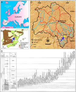
Figure 1. The Checa geosite. A‒C) The location of the on a map of Europe (A), of the Iberian Peninsula (B) and of the Alto Tajo Geopark (C). Arrowed in B is the location of the Geopark in the Western Iberian Cordillera, and in C the more detailed location of the Checa section. D) Reduced version of the stratigraphic log of the Silurian of Checa (reproduced from Gutiérrez-Marco & Štorch 1998, fig. 6) showing the successive biostratigraphic ranges of the more than 80 graptolite species identified so far.
Location
The Checa graptolitic section is situated in the south-eastern part of Molina-Alto Tajo Geopark (Fig. 1A‒C), in the west-central part of the Nevera Paleozoic inlier of the Sierra de Albarracín Alpine Antiform, ca. 5,500 m west of the Nevera peak (1,833 m high). It lies towards the core and eastern flank of a N–S running syncline that crosses the road CM-2111 from Checa to Orea between km 24 and 25, near La Tejera on the right bank of the Cabrillas river valley. The Silurian section is located 790‒890 m ENE from the cemetery of the town of Checa, province of Guadalajara, and extends from the erosive base of the Los Puertos Formation to a horizon situated approximately 60 m above the base of the Bádenas Formation. A complementary section with fossiliferous black shale intercalations recorded in the upper part of Los Puertos quartzites is present in the western flank of a different syncline directly to the east, ca. 820 m NW of the Peña Blanca hill (1,543 m high), towards km 25.5 of the road cited above.
Significance of the Checa Silurian Geosite
Lower Silurian black shales are widespread in peri-Gondwanan Europe, with some spectacular and fossiliferous sections recorded from several places within the Variscan terranes of Spain and Portugal, Sardinia, the Carnic Alps, Thuringia and Bohemia, which belong to a cool-water graptolite province developed during the Llandovery and early Wenlock (Štorch 1998b). The Llandovery succession of the Checa Geosite is one of the most continuous for the Telychian Stage in this paleoprovincial context, being of special interest for its extremely rich graptolite content (Figs. 2 and 3) that has facilitated high-resolution correlations with other areas such as Bohemia, Thuringia, Sardinia, Bornholm, Wales, Libya and Algeria (Gutiérrez-Marco & Štorch 1998; Štorch 1998b; Štorch & Massa 2007). The graptolite record of the Bádenas Formation starts in the lower part of the guerichi Biozone and ranges up to the spiralis Biozone. Well-preserved pyritized graptolites occur throughout the sequence. It is also the type locality of four new graptolite species discovered in the upper guerichi Biozone, upper tullbergi Biozone and in the griestoniensis Biozone. Two of these (Torquigraptus australis, Streptograptus pericoi) have been subsequently recognized outside Spain, in Bohemia, Sardinia, Wales (the former) and as far as a field in central Laos (the latter). Interesting examples of micaceous, silty black shales with bedding planes crowded with fragmented graptolites, possibly generated by wave action, are common near the base of the Bádenas Formation. A unimodal WNW-ESE current-driven graptolite alignment is common from about the middle part of the guerichi Biozone until at least the griestoniensis Biozone (Fig. 2A). Current-oriented graptolites in the lower part of the turriculatus Biozone are associated with contourite-like, sandy-micaceous laminites. The non-graptolite macrofossils of the Bádenas Formation include rare remains of eurypterids, phyllocarids, cornulitids, orthoconic nautiloids, ‘paper-shelled’ rhynchonellid brachiopods, and very rare trilobites.
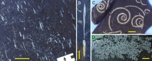
Figure 2. Some Telychian graptolites from the Checa section. A‒B) Parapetalolithus palmeus (Barrande), from the upper guerichi Biozone; A, current-oriented rhabdosomes mainly belonging to this relatively wide biserial form); B, rhabdosome with a large distal extrathecal structure (nematularium) formed by three vanes. C‒D) Oktavites spiralis (Geinitz), from the spiralis Biozone: C, three flattened low-helically spiraled rhabdosomes with broken proximal ends; D, rhabdosomes clustered by currents. Scale bars 50 mm (A, D) and 10 mm (B, C).
Llandovery graptolites recorded from the black shale intercalations in the upper part of the Los Puertos Formation belong to older Silurian assemblages from the Rhuddanian acuminatus, vesiculosus and cyphus biozones, as well as from the Aeronian triangulatus and convolutus biozones (Gutiérrez-Marco & Štorch 1998; Štorch & Gutiérrez-Marco 1998).
In addition to the stratigraphic relevance of the Checa section in the context of the Iberian Silurian (Gutiérrez-Marco et al. 1998; Robardet & Gutiérrez-Marco 2002; Molina et al. 2018), the graptolitic black shales have also provided interesting petrological data on clay-mineral genesis (Bauluz & Subías 2006, 2010), as well as some experiments on CO2 and CH4 gas adsorption (Pozo et al. 2017; Ortiz Cancino et al. 2017).
Geotourism Significance and Geotrail Potential
The outstanding Silurian section of Checa is well known among graptolite specialists and Paleozoic geologists, having been visited by the Graptolite Working Group of the International Palaeontological Association and the International Subcommission on Silurian Stratigraphy (1998), and in diverse field trips organized in the frame of IGCP projects (such as IGCP 503 in 2007) and international symposia (such as the ISOS–2011). This important Silurian outcrop is within the territory of the Alto Tajo Natural Park (declared in 1989), that in 2006 provided several geoconservation initiatives (see below). Also, the Park incorporated the site into one of their geo-itineraries arranged for visitors (Geo-route # 8, ‘Secrets hidden in the rocks’: Carcavilla et al. 2008). The La Tejera Interpretive Area, at stop # 1 of the same Geo-route, and adjacent to the graptolite shales, offers fixed information panels explaining, for instance, what graptolites are, their geological age and the scientific importance of this fossil locality (Fig. 3C).
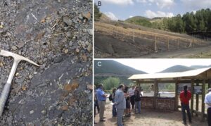
Figure 3. The Checa geosite. A) Field photograph of the black shales of the Bádenas Formation showing graptolites on the surface outcrop, revealing the prolific character of this fossil locality. B) A partial view of the fenced part of the Silurian section, which includes the guerichi and lower turriculatus biozones in the basal 10 m of the black shales. C) Fixed information panels in the La Tejera Interpretive Area explaining the significance of the Checa graptolite locality.
Finally, public awareness of the geosite is also ensured by the continuous popularization efforts by the Natural Park and by the Geopark, which include brochures, web applications, integration in the education plans and various publications in the framework of regional Palaeontology (Gutiérrez-Marco & Rábano 1999; Gutiérrez-Marco et al. 2008a; Molina et al. 2018), Geodiversity (Carcavilla et al. 2013), Geotourism (Saiz et al. 2015) and Palaeontological Heritage (Gutiérrez-Marco et al., in press).
Geosite Conservation
The Checa section was cataloged in 2008 as a Spanish geological place of international significance (Geosite PZ-005 in Gutiérrez-Marco et al. 2008; LIG # 9 in Carcavilla & Palacio 2010), in the frame of the project ‘Global Geosites’ coordinated by the European Association for the Conservation of the Geological Heritage (ProGEO – IUGS) and made official by the Spanish Geological Survey (IGME). The Castilla-La Mancha Regional Government gives the area other protection designation, which led to its inclusion in the master plan for the use and management of the Alto Tajo Natural Park in which the outcrop is located (Carcavilla & Ruiz López de la Cova 2009). The most notable action carried out to date was the fencing of some 2,400 square meters of the paleontological site for its geoconservation and exclusive scientific use (Fig. 3B). This protected part includes the guerichi and lower turriculatus biozones, representing the lowest 10 m of the Bádenas Formation, which are at highest risk of degradation and easy plunder by collectors, and are of greatest scientific interest.
Summary
The Checa Geosite in the Molina-Alto Tajo Geopark is of obvious interest from the geological heritage perspective and has an added educational value because it offers a spectacular outcrop of the sedimentary rocks and events related to a peri-polar area of the Gondwanan continent in the Ordovician-Silurian boundary interval. Around the La Tejera Interpretative Area of the Geopark, the glaciomarine sedimentary rocks of the Orea Formation include dropstones carried by icebergs created by the Late Ordovician glaciation. Above a clear erosive unconformity incised at the top of the Orea Formation is the quartzite of the Los Puertos Formation, which represents the first Silurian (Rhuddanian-Aeronian) deposits. Above it, the basal 60 m of the Bádenas Formation consists of typical black shales exposed at one of the richest and best-preserved graptolite fossil localities on the Iberian Peninsula. Besides the scientific papers and regional guides, it also appears prominently in the lists of Ordovician-Silurian geosites of the Iberian Peninsula with considerable international significance (Gutiérrez-Marco et al. 2008b, c).
References
Álvaro JJ & Van Vliet-Lanoë B (2009). Late Ordovician carbonate productivity and glaciomarine record under quiescent and active extensional tectonics in NE Spain. Geological Society of London, Special Publications. 325: 117–139.
Bauluz B & Subías L (2006). Pirofilita –I/S– ilita amónica en las pizarras negras de la Sierra de Albarracín (Guadalajara y Teruel). Macla. 6: 81–84.
Bauluz B & Subías L (2010). Coexistence of pyrophyllite, I-S, R1 and NH4-rich illite in Silurian black shales (Sierra de Albarracín, NE Spain): metamorphic vs. hydrothermal origin. Clay Minerals. 45: 383–392.
Carcavilla L & Ruiz López de la Cova R (2009). La geoconservación en Castilla-La Mancha. Estado actual y perspectivas de futuro. Cuaternario y Geomorfología. 23: 11–26.
Carcavilla L & Palacio J (2010). Geosites: aportación española al patrimonio geológico mundial. Madrid: IGME.
Carcavilla L, Ruiz R & Rodríguez E (2008). Guía geológica del Parque Natural del Alto Tajo. Junta de Comunidades de Castilla-La Mancha.
Carcavilla Urquí L, Vela Layna A & Ruiz López de la Cova R (2013). Geodiversidad y biodiversidad del Parque Natural del Alto Tajo. Madrid: Real Sociedad Española de Historia Natural.
Castel C (1881). Descripción física, geognóstica, agrícola y forestal de la provincia de Guadalajara. Boletín de la Comisión del Mapa Geológico de España. 8: 157–264.
Gutiérrez-Marco JC (1999). Algunos ejemplos inusuales de nematulario en graptolitos silúricos del noreste de España. Temas Geológico-Mineros ITGE.26: 239–243.
Gutiérrez-Marco JC & Rábano I (1999). Paleontología del Neoproterozoico y Paleozoico Inferior de Castilla-La Mancha. In Aguirre E Rábano, I (Eds), La huella del pasado: fósiles de Castilla-La Mancha (pp. 25–50). Toledo, Junta de Comunidades de Castilla-La Mancha, Serie "Patrimonio Histórico. Arqueología de Castilla-La Mancha" 16.
Gutiérrez-Marco JC & Štorch P (1998). Graptolite biostratigraphy of the Lower Silurian (Llandovery) shelf deposits of the Western Iberian Cordillera, Spain. Geological Magazine. 135: 71–92.
Gutiérrez-Marco JC, Robardet M & Piçarra JM (1998). Silurian Stratigraphy and Paleogeography of the Iberian Peninsula (Spain and Portugal). Temas Geológico-Mineros ITGE. 23: 13–44.
Gutiérrez-Marco JC, Herranz P, Pieren AP, Carls P & Rábano I (2008a). Los sedimentos paleozoicos del viejo continente de Gondwana. In Calonge A, Rodríguez M (Eds), Geología de Guadalajara (pp. 75–93). Universidad de Alcalá de Henares, Obras Colectivas Ciencias 03.
Gutiérrez-Marco JC, Rábano I, Liñán E, Gozalo R, Fernández Martínez E, Arbizu M, Méndez-Bedia I, Pieren Pidal A & Sarmiento GN (2008b). Las sucesiones estratigráficas del Paleozoico inferior y medio del Macizo Hespérico. In García-Cortés A (Ed), Contextos Geológicos españoles. Una aproximación al patrimonio geológico español de relevancia internacional (pp. 31‒43). Madrid: Instituto Geológico y Minero de España.
Gutiérrez-Marco JC, Rábano I, Sá A.A, San José MA, Pieren Pidal AP, Sarmiento GN, Piçarra J.M, Durán JJ, Baeza E & Lorenzo S (2008c). Fósiles y Patrimonio Geológico del Ordovícico y Silúrico en espacios naturales singulares de la Península Ibérica. In Ruiz-Omeñaca JI. Piñuela L, García-Ramos JC (Eds), Libro de Resúmenes XXIV Jornadas de la Sociedad Española de Paleontología (pp. 134–135). Colunga, Museo del Jurásico de Asturias.
Gutiérrez-Marco JC, Rábano I, Sá AA & Carcavilla Urquí L (2013). Sedimentos glaciomarinos del Ordovícico terminal en el candidato a Geoparque de Molina-Alto Tajo (Guadalajara): protección y difusión de un LIG de rango internacional. In Vegas J, A Salazar, Díaz-Martínez E, Marchán C (Eds), Patrimonio geológico, un recurso para el desarrollo. (pp. 241–250) IGME, Cuadernos del Museo Geominero. .
Gutiérrez-Marco JC, Rábano I, Romero Gómez S, Colmenar J, Herranz Araújo P & Štorch P (In press). Fósiles del Paleozoico inferior (Ordovícico y Silúrico) del Geoparque Mundial de la UNESCO Molina-Alto Tajo (Guadalajara). In Calonge A, Carcavilla L (Eds.), Guía de Fósiles del Geoparque Mundial de la UNESCO de Molina-Alto Tajo (Guadalajara). Diputación de Guadalajara.
Hernández Sampelayo P (1960). Graptolítidos españoles. Recopilados por Rafael Fernández-Rubio. Notas y Comunicaciones del Instituto Geológico y Minero de España. 57: 3–77
Kindelán V& Ranz M (1918). Criaderos de Hierro de España. Tomo III. Criaderos de Guadalajara y Teruel. Memorias del Instituto Geológico de España. 29: 1–230
Molina E, Company M, Dies ME, Sandoval J & Sierro FJ (2018). Principales yacimientos marinos de interés para el patrimonio paleontológico en la Península Ibérica e Islas Baleares. Revista PH. 94: 64–115
Ortiz Cancino OP, Pino Pérez D, Pozo M & Bessieres D (2017). Adsorption of pure CO2 and a CO2/CH4 mixture on a black shale sample: Manometry and microcalorimetry measurements. Journal of Petroleum Science and Engineering. 159: 307–313.
Pozo M, Pino D & Bessieres D (2017). Effect of thermal events on maturation and methane adsorption of Silurian black shales (Checa, Spain). Applied Clay Science. 136: 208–218.
Riba Arderiú O (1959). Estudio geológico de la Sierra de Albarracín. Monografías del Instituto "Lucas Mallada" de Geología (CSIC). 16: 1–283.
Robardet M & Gutiérrez-Marco JC (2002). Silurian. In Gibbons W, Moreno T (Eds), The Geology of Spain (pp. 51–66). London:The Geological Society.
Rondeel HE, Weijermars R & van Dorssen HG (1984). Reactivation of early reverse faults associated with oblique strike-slip faulting: A mechanism for crustal shortening (Macizo del Nevera, Sierra de Albarracín, Spain). Geologie en Minjbouw. 63: 387–398.
Saiz A, Sanz C, Yarza C, Sanz D, Ruiz J, Lozano JA, Monasterio JM, Carcavilla L, Viorreta M, Perruca M, Langa MA, Barahona M, Leyva O de, Marco R & García R (2015). Guía turística del Geoparque de la Comarca de Molina-Alto Tajo. Asociación de Desarrollo Rural Molina de Aragón-Alto Tajo: Guadalajara.
Štorch P (1998a). New data on Telychian (Upper Llandovery, Silurian) graptolites from Spain. Journal of the Czech Geological Society. 43: 113–141.
Štorch P (1998b). Biostratigraphy, palaeobiogeographical links and environmental interpretation of the Llandovery and Wenlock graptolite faunas of peri-Gondwanan Europe. Temas Geológico-Mineros ITGE. 23: 126–129.
Štorch P & Gutiérrez-Marco JC (1998). Silurian sections of the Castilian Branch of the Iberian Cordillera (provinces of Guadalajara and Teruel). Temas Geológico-Mineros ITGE. 23: 326–335.
Štorch P & Massa D (2007). Middle Telychian (upper Llandovery, Silurian) graptolites from boreholes of northwestern Libya: Their biostratigraphic significance and palaeogeographical implication. GEOBIOS. 40: 535–540.
Verneuil E & Collomb E (1853). Coup d'oeil sur la constitution géologique de quelques provinces de l'Espagne. Bulletin de la Société Géologique de France [2].10: 61–176.