Introduction
Volcanic eruptions and the resulting volcanic structures are among the most fascinating natural processes and the most stunning landscapes on Earth (Erfurt-Cooper 2011, 2014; Erfurt-Cooper et al. 2015; Erfurt 2022). Many people are interested in exploring unique natural areas and knowing more about the history of natural processes. Volcano tourism is currently a dynamically evolving segment of the travel industry and contributes significantly to the economic development of local areas (Erfurt-Cooper et al. 2015). This is valid not only for active volcano destinations, but also for inactive volcanic regions (Erfurt-Cooper 2014). While active and potentially active volcanoes are areas mostly of adventure tourism, both attracting visitors by the eruption processes and by climbing a ‘living’ volcanic edifice, long-dormant and inactive volcanic areas have the potential to provide additional knowledge of how and why volcanoes work. National parks and, since the beginning of this century, geoparks have played a significant role in unfolding the geodiversity and geoconservation of volcanic areas (Németh 2022; Nunes 2022). Volcanological research has a fundamental role in revealing the geoheritage values and promoting geoeducation. This is not necessarily confined to the magmatic and volcanic processes, but also involves relationships between volcanoes, the volcanic landscape and historical, cultural and religious heritage (Ertekin et al. 2021). Geoparks are built on this holistic view and therefore are ideal places to discover the role of volcanoes in our society. This is also important to deliver key messages about volcanic hazards and risks and prepare people for future volcanic events with effects on local and global scales (Németh 2022 and references therein).
The Carpathian–Pannonian Region in eastern–central Europe is rich in volcanic heritage since diverse volcanic activity took place in this area for the last 20 Myr (Harangi 2001, 2014; Seghedi et al. 2004a; Pécskay et al. 2006; Harangi & Lenkey 2007; Lexa et al. 2010; Seghedi & Downes 2011). Volcanic eruptions were fed by various magmas from basaltic to high-silicic, and these resulted in different volcanic structures. They have been variously eroded through time and therefore even the root zones of volcanoes are exposed in many places. Thus, this area can be considered as a kind of natural laboratory of volcanoes, where their evolution can be understood from the source, i.e., from the magma generation through the magma evolution processes up to the eruption processes. This is based on extensive volcanological, petrological and geochemical scientific work over more than a century and at the international level (Martin & Németh 2004; Harangi & Lukács 2019 and references therein).
Among the volcanic areas of the Carpathian–Pannonian Region, the Bakony–Balaton Uplands in western Hungary serve as an ideal place for geotourism because of the notable geodiversity, a solid knowledge about the volcanic history based on intensive scientific studies and in particular, the exceptional beauty of the volcanic landscape (Korbély 2014; Harangi 2019; Pál and Albert 2023; Fig. 1 and 2). Furthermore, this is one of the most popular tourist destinations in Hungary thanks to Lake Balaton, the largest fresh-water lake in Central Europe. The first landscape reserve in Hungary was designated in the Tihany Peninsula recognizing its geological and biological uniqueness in 1952. It became an integral part of the Balaton Uplands National Park established in 1997 and the Bakony–Balaton Geopark established in 2006. The geopark, managed by the Balaton Uplands National Park Directorate, has been a member of the Global Geoparks Network since 2013 and it was designated as a UNESCO Global Geopark in 2015.
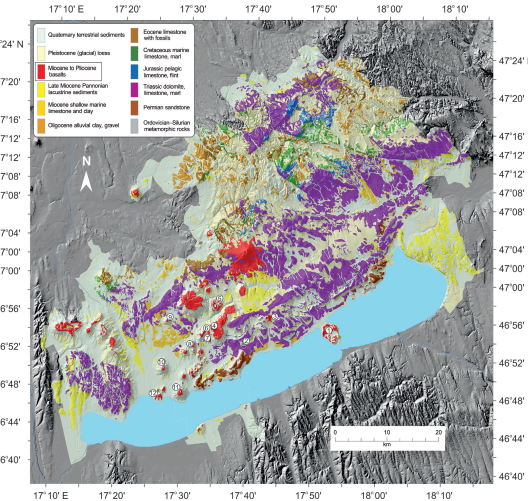
Figure 1. Geological diversity of the area of the Bakony–Balaton Uplands UNESCO Global Geopark (BBUGGp; based on the geological map of Budai et al. 1999). Red colour marks the Miocene to Pliocene (8–2.3 Ma; Wijbrans et al. 2007) basalts. Localities of key volcanic natural values are indicated by numbers: 1. Tihany (Tihany Levander Visitor Centre); 2. Hegyestű (Hegyestű Visitor Centre); 3. Halom Hill; 4. Boncsos-tető – Fekete Hill; 5. Bondoró; 6. Füzes-tó – Kopácsi Hill; 7. Szentbékkálla; 8. Hajagos; 9. Haláp; 10. Szent György Hill; 11. Badacsony; 12. Szigliget. For location of the BBUGGp within the Carpathian–Pannonian Region, see Fig. 3.
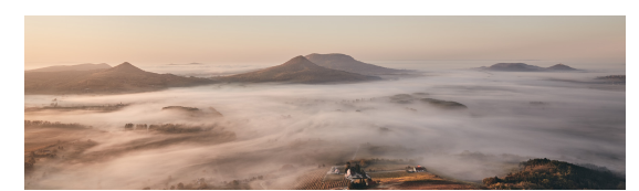
Figure 2. The basalt remnant hills (from right to left: Szigliget, Badacsony, Gulács, Tóti Hill) rising above the fog in the Bakony–Balaton UNESCO Global Geopark. Photo: András Takács (view from north to south)
The Bakony–Balaton UNESCO Global Geopark plays a progressive role in the network of geoparks in volcanic areas of Europe (Nunes 2022). Such a leading role has been particularly supported by scientific results, which unfolded the origin and details of the volcanic history in this area. Among the great researchers who worked in this area, the volcanological studies by Károly Németh must be particularly emphasized (e.g., Németh & Martin 1999a; Németh et al. 2001; Martin & Németh 2004; Németh 2011 and references therein), who made the Bakony–Balaton Uplands basalt volcanic field (note that in the scientific literature, it is usually called as Bakony–Balaton Highland volcanic field) an internationally renowned volcanological natural laboratory.
The International Maar Conference held in Hungary in 2004 (Niu et al. 2005) was a milestone, when scientists from all over the world visited the area on the conference fieldtrip and the peculiar volcanological features became embedded in the volcanology community mindset. Notably, the Bakony–Balaton Uplands National Park was one of the main sponsors of this successful scientific meeting that helped it on the way to establishing the science-based geopark idea. Building on the scientific research, two visitor centers with attractive volcanological exhibitions and several volcanological nature trails were developed recently. The geotour-guide training courses led by specialists helped involve local people in running regular outdoor geoeducational activity days. Thus, the Bakony–Balaton UNESCO Global Geopark provides a nice example of how scientific results can be transformed into geoeducation and geoconservation.
Volcanic Geoheritage of the Carpathian–Pannonian Region
The volcanic geoheritage of the Bakony–Balaton area represents an important part of the rich volcanic history of the Carpathian–Pannonian Region (CPR; Fig. 3). The landscape of the CPR was heavily influenced by volcanic activity occurring contemporaneously with the formation of the Pannonian Basin for the last 20 Myr (Harangi 2001; Seghedi et al. 2004a; 2005; Lexa et al. 2010). Repeated violent explosive eruptions of silicic magmas covered the area with pumiceous pyroclastic deposits during an ignimbrite flare-up episode from 18.1–14.4 Ma (Lukács et al. 2015, 2018, 2021). Distal volcanic material from these eruptions has been documented around the CPR and even beyond that (Lukács et al. 2018; Rocholl et al. 2018; Brlek et al. 2023) proving that this volcanic activity affected a large part of Europe and confirming that these eruptions can be considered as being among the largest in Europe during the last 20 Myr (Lukács et al. 2018; Karátson et al. 2022; Brlek et al. 2023).
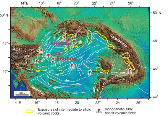
Figure 3. Exposures of the Neogene to Quaternary volcanic rocks in the Carpathian-Pannonian Region and the location of the Bakony–Balaton UNESCO Global Geopark (BBUGGp). The Novohrad–Nógrád UNESCO Global Geopark (NNUGGp) and the Kemenes Volcano Park (KVP) are also indicated in the map. Monogenetic basalt volcanic fields: 1. Burgenland; 2. Styrian basin; 3. Little Hungarian Plain (Kemenesalja); 4. Bakony–Balaton Uplands; 5. Stiavnica; 6. Nógrád–Gemer; 7. Kecel and the surroundings (buried); 8. Lucaret; 9. Perşani. Source of the topographic map: Horváth et al. (2006); tectonic lineaments: Horváth et al. (2015)
Partly contemporaneously with these caldera-forming eruptions, andesitic to rhyolitic volcanism started building a set of complex composite volcanic structures mostly along the Carpathian orogenic chain. Although such volcanism is usually connected to the subduction of an oceanic plate, there is a lack of geological and geophysical evidence for this. Alternatively, it could have been related to the main extensional phase (12–18 Ma) in the Pannonian Basin, when the lithosphere, as well as the continental crust thinned considerably (Lexa & Konečny 1974; Harangi et al. 2007; Harangi 2001; Harangi & Lenkey 2007). Development of steep-sided conical volcanoes was often followed by a catastrophic sector collapse event (Karátson et al. 2000, 2001, 2007; Szakács & Seghedi 2000; Lexa et al. 2010) just as occurred at Mt St Helens (Washington, USA), Bezymianny (Kamchatka, Russia), Shiveluch (Kamchatka, Russia) and also at several volcanoes in the Andes such as Socompa on the border between Chile and Argentina (Francis & Wells 1988). The dominantly andesitic to dacitic volcanism continued on the eastern margin of the Pannonian basin during the last 12 My and the latest eruption occurred only 30 ka (Harangi et al. 2010; 2015; 2020; Molnár et al. 2019; Karátson et al. 2019). Since most of these eruptions in the East Carpathians took place following the collision of continental blocks, they are considered post-collisional type (Seghedi et al. 2004a; 2019). Volcanic structures along a 160 km long belt (called Călimani–Gurghiu–Harghita volcanic chain, Romania) parallel with the Outer Carpathians are remarkably preserved (Dibacto et al. 2020).
A particular type of volcanic activity forming scattered monogenetic volcanic fields within the Pannonian Basin (Fig. 3) commenced at 12 Ma but culminated mostly around 5–2 Ma (Balogh et al. 1982; 1986; Wijbrans et al. 2007). This occurred after the peak extension and mostly during the post-extensional thermal subsidence period, therefore, the reason for basalt volcanism is still unclear (Harangi 2001; Seghedi et al. 2004b; Harangi & Lenkey 2007; Harangi et al. 2015; Kovács et al. 2020). Remarkably, most of these volcanic fields are located in the marginal parts of the Pannonian Basin and not in areas underlain by the thinnest lithosphere. The basaltic magmas generated in the asthenosphere and most of them rapidly, i.e., within days, reached the surface (Harangi et al. 2013; Jankovics et al. 2013). Almost all volcanic forms associated with basaltic volcanism were developed here from maars to shield volcanoes (Kereszturi et al. 2010, 2011). The last basalt volcanic eruption occurred only 100 ka in the northern part of the Pannonian Basin (Štiavnica volcanic field; Fig. 3, Šimon & Halouzka 1996; Šimon & Maglay 2005) indicating that the asthenospheric mantle can still melt and produce mafic magma that can reach the surface successfully.
In summary, the Carpathian–Pannonian Region is an excellent area where volcanic landforms and processes related to the eruption of a wide range of magmas, i.e., from basalt to rhyolite, are preserved and can be observed at various scales. Extensive volcanological studies going back more than a century and accelerated for the last 30 years using modern views of volcanology have formed the solid knowledge on which the scientific values of the unique geoheritage can be evaluated and transferred to the public, promoting geotourism and geoeducation (Harangi 2014; Korbély 2014; Németh 2022). Building on the natural values of volcanic activity, two geoparks are already established in this region (Novohrad–Nógrád Geopark and Bakony–Balaton Geopark; Fig. 3), both designated as UNESCO Global Geoparks in 2015. In addition, a thematic volcanic park with a visitor center (Kemenes Volcano Park; Harangi 2014, Fig. 3) was opened at the foot of a 5.3 Ma basalt volcano in western Hungary (Ság Hill; Harangi & Harangi 1995) in 2012 demonstrating the exceptional values of volcanic geoheritage.
Development of a Monogenetic Volcanic Field
The monogenetic volcanic field is a specific type of volcanism, when a mostly small volume of magma erupts intermittently and always in a new place (Connor & Conway 2000; Valentine & Gregg 2008; Németh 2010; Németh & Kereszturi 2015; Valentine & Connor 2015; Smith & Németh 2017). It consists of many individual volcanoes in an area of several hundred to thousand square kilometers. Eruptions are short (occurring within days to up to a few years) and take place through the same conduit. The lifetime of such volcanic fields could be several million years, and long quiescence (hundreds to 100 thousand years) periods elapse between eruptions (Valentine & Connor 2015). Since the basaltic magma always finds a new place to erupt and there is a long repose time, forecasting eruptions in such areas is difficult. Intense studies of basalt volcanic fields started in the 1980s focusing on the influence of basalt volcanism on a proposed nuclear waste repository in the western USA (Crowe & Carr 1980; Crowe et al. 1983) and have accelerated noticeably since that time. At the beginning of the 21st century, the considerable volcanic hazard and risk at Auckland were recognized (Lindsay 2010; Hopkins et al. 2020), although such assessments go back to the 1960s (e.g., Searle 1964). This emphasized the need for a better understanding of how volcanic fields work. Magmas that feed eruptions are generated in the upper mantle usually by a small degree of melting and either ascend straight to the surface or ponds at the crust-mantle boundary, where they are accumulated and mixed for prolonged periods (Smith & Németh 2017).
One of the excellent natural laboratories where the nature of basalt volcanic fields can be studied is the Pannonian Basin (Fig. 3; Martin & Németh 2004; Harangi et al. 2015). Here, several volcanic fields were developed between 8 Ma and 1 Ma (Pécskay et al. 2006). Among them, the Bakony–Balaton Uplands area is where most research has been carried out. This volcanic field consists of more than 50 volcanic centers, with a wide variation of volcano types from maars to shield volcanoes formed from 8–2.4 Ma (Balogh et al. 1982, 1986; Wijbrans et al. 2007). Almost all volcanic eruption types characterizing the basalt volcanism can be recognized here, such as hydrovolcanic (phreatic to phreatomagmatic eruptions) and magmatic (Strombolian and Hawaiian) explosive eruptions with proximal and distal pyroclastic deposits, clastogenetic lava, valley-channeled lava flow, lava lake and vent-filling basalts (Fig. 4). Since significant uplift and erosion occurred after the volcanism ceased, the original volcanic edifices have been variously eroded. Due to the various erosive forces, the loose volcaniclastic materials were transported away and in many places, the volcanoes eroded down to their root-zones. This enabled the unique exposure of the vent and conduit sections. The lava lake and valley-filled basalts were resistant to erosion that resulted in an inverted morphology landscape that yields the beauty of the Tapolca Basin (Fig. 4A).
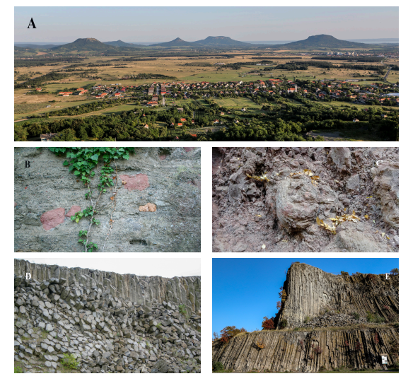
Figure 4. A) Typical view of the basalt remnant hills (from left to right: Csobánc, Tóti Hill, Gulács, Badacsony, Szent György Hill) of the Tapolca Basin from the Haláp, west of the BBUGGp. B) Lithic-rich massive pyroclastic product of maar-type explosive eruption (Tihany); C) Typical vesiculated scoria and spatter pyroclastic deposit of Strombolian to Hawaiian-type eruptions (Boncsos-tető, Fekete Hill); D) Columnar-jointed basalt lava rocks (Haláp); E) Columnar-jointed lava lake basalt/basanite at Hegyestű.
The Bakony–Balaton Uplands Volcanic Field provides insight into the development of basalt volcanoes from source to the surface (Harangi 2019; Németh et al. 2020). Basalt, which is an excellent construction material, has been quarried at several places for centuries. This led to a unique exposure to the interior of the volcanic edifices as well as the nature of the volcanic products in detail. Active quarrying continues at the western margin of the volcanic field, while the abandoned quarries now are partially protected and used for geoeducational purposes.
The Bakony–Balaton UNESCO Global Geopark
The Bakony–Balaton UNESCO Global Geopark (BBUGGp) covers more than 3200 square kilometers near Lake Balaton (Fig. 1), which is a popular destination for domestic and international tourists (Korbély 2014). The geopark plays a leading role in enhancing the visibility of geoheritage in a sustainable way with a mission to protect and interpret the rich geological and geomorphologic heritage, with the involvement of local people and communities. The great variety of geological heritage found in the Balaton Uplands and Bakony areas (a comprehensive presentation of the geodiversity of this area is found in the explanation book for the 1:50 000 geological map; Budai et al. 1999) is used in connection with all other aspects of the area’s natural, cultural and historical heritage to enhance awareness and understanding of key issues facing society, such as using Earth’s resources sustainably. This heritage gives local people a sense of pride in their region and strengthens their identification with the area. High quality scientific studies and training courses for local people develop innovative ways to protect and exhibit the natural values through geotourism, while the geological resources of the area are preserved. It plays a leading role also in emphasizing the volcanic heritage of geoparks and how this can enhance the visibility of volcanic activity, which has importance not only in attracting people, but also in increasing volcanic hazard awareness and disaster preparedness.
Specific Volcanological Features in the BBUGGp
Wide Range of Basaltic Pyroclastic Deposits
Basaltic magma can erupt in various ways. They mostly feed effusive eruptions, providing lava flows, although spectacular explosive eruptions also occur, mostly during the initial phases. These explosive eruptions are due either to the interaction between the uprising hot magma with groundwater stored in various aquifers (called hydrovolcanic explosive eruptions; Sheridan & Wohletz 1983) or to the internal pressure of a large amount of exsolved gas within the upper portion of the magma body. The mechanism of explosive eruption is reflected both in the nature of the deposited pyroclastic material (i.e., volcaniclastic deposit formed by explosive volcanism), such as grain size, shape and lithology of the clasts and the deposition condition (fall or mass flow). Further, they build distinct volcanic edifices, such as deep maars, tuff rings, tuff cones, scoria and spatter cones with decreasing water/magma ratio (Wohletz & Sheridan 1983).
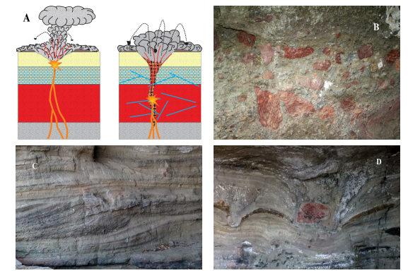
Figure 5. A) Two types of hydrovolcanic explosive eruptions: phreatomagmatic eruption caused by interaction between magma and partially unconsolidated, wet sandy ‘soft-substrate’ deposit (porous media aquifer) and maar-type eruption resulted from magma-water interaction in ‘hard-substrate’ fracture-controlled aquifer (after Németh et al. 2001; 2010). B) Typical eruption products of a maar-type explosive event: note that abundance of Permian red sandstone clasts excavated deep beneath the volcano; C) Cross-stratified pyroclastic surge deposit suggesting flow direction from left to right direction; D) Bomb-sags formed beneath ballistic bombs in wet pyroclastic beds. Photos B-D: Barátlakások outcrop, Tihany peninsula
In the area of the BBUGGp, fine examples of all these explosive eruption mechanisms can be recognized (Fig. 4B-C). Maar volcanic explosive eruptions occur deep beneath the surface, excavating a large number of basement rocks. This type of pyroclastic deposit is nicely exposed at the eastern side of the Tihany Peninsula (Barátlakások outcrop, a relatively intact monk settlement of the 10–11th centuries, the only one in Central Europe). Németh et al. (2001) described here a specific type of maar volcanism, called Tihany-type eruptions (Fig. 5). The structural and textural features of the pyroclastic surge beds suggest wet deposition, i.e., hydrovolcanic explosive eruptions when a large amount of steam is incorporated into the erupted material. This usually indicates shallow interaction of magma and water, often in an open vent and is characteristic of tuff-cone forming eruptions. However, many deep excavated lithic clasts (mostly Silurian schist and Permian red sandstone; Figs. 4B, 5B) can be observed in these pyroclastic deposits implying deep maar crater excavation. In combining these two distinct features, Németh et al. (2001) proposed that progressive maar crater excavation could reach the deep fracture-controlled aquifer, where a large continuous water supply resulted in the explosive interactions forming wet, lithic clast eruption material. It is noteworthy in the lower sections that fewer lithic clasts occur, and they are mostly Pannonian marl and sandstone clasts. This means that the initial explosive eruptions occurred in a shallow porous media aquifer followed by a down-migrating explosive locus and progressively deeper maar crater (Fig. 5A). Pyroclastic surge beds with remarkable cross-stratification and antidune structures along with the common occurrence of bomb-sags beneath ballistic bombs imply the direction of source areas and suggest coeval eruptions from different craters (Fig. 5C–D).
Another spectacular maar volcanic formation is exposed north of Szentbékkálla village (Németh & Martin 1999b), containing fragments from almost the entire lithosphere (Fig. 6A). There are abundant peridotite clasts incorporated into the rapidly uprising basaltic magma en route through the lithospheric mantle (Embey-Isztin et al. 1989, 2001; Bali et al. 2002, 2008; Szabó et al. 2004; Ntaflos et al. 2017). The lower crust is represented by sparse granulite fragments (Embey-Isztin et al. 1990; Kempton et al. 1997; Török et al. 2005, 2014), whereas Silurian schist, Permian red sandstone, Mesozoic dolomite and limestone, Pannonian sandstone from the upper crust, i.e., various rocks which outcrop in the Balaton Uplands and Bakony region can be found in this single pyroclastic bed.
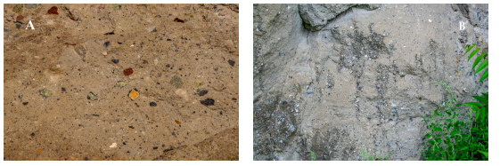
Figure 6. Unique features of the basaltic pyroclastic flow (note that Németh & Martin 1999 denoted it as hydroclastic flow) deposit at Szentbékkálla formed by maar-type explosive eruption: A) abundance of various lithic clasts, representing the whole lithosphere including peridotite fragments from the upper mantle. It suggests maar-type explosive eruption; B) Such basaltic pyroclastic flow rare worldwide. It contains gas segregation channels formed by elutriation of fines during the bypass of gas through the pyroclastic flow deposit.
The onset of eruption events was characterized typically by hydrovolcanic eruptions, i.e., the interaction of basaltic magma and groundwater and/or water-saturated sediments. The eruption type was controlled primarily by the hydrogeologic character of the bed rocks (Németh et al. 2001; Martin & Németh 2004; Auer et al. 2007; Németh et al. 2010). Maar-type explosive events occurred where fracture-controlled aquifers (‘hard-substrate’; Palaeozoic to Mesozoic formations) dominated the shallow subsurface basement section, whereas tuff-ring building phreatomagmatic eruptions occurred where thick partially unconsolidated, ‘soft-substrate’ Pannonian sandy deposits, i.e., porous media aquifer built-up the shallow basement (Fig. 5A). The latter pyroclastic rocks contain fewer lithic fragments, alternation of pyroclastic surge (tuff) and fall-out (lapilli tuff and lapillistone) layers are common. Such deposits are much rarer in this volcanic field, since these loose clastic materials were easily eroded after the termination of volcanism.
The other end-member explosive eruption mechanism is triggered by the abundant exsolved gas fraction at the top of the uprising magma column. Overpressure of the gas bubbles caused either Strombolian-type firework eruption or Hawaiian-type lava-fountaining and lava spatter depending primarily on the magma ascent speed (Parfitt & Wilson 1995). Such eruptions occurred mostly following the initial hydrovolcanic eruptions when the water/magma mixing ratio drastically decreased. As a result, scoria cones and spatter cones developed within the craters of the wide maars or tuff rings (Fig. 4C). The pyroclastic products contain mostly highly vesicular scoriae and fluidal-shape basalt spatters. Spindle-shaped bombs and cracked basaltic bombs (Fig. 7) with occasional bread crusted surfaces formed by ballistic ejections of partially molten material are typical during such eruptions and occur occasionally (e.g. Bondoró Hill, Füzes-tó/Kopácsi Hill) in this volcanic field. The best exposure of the transitional Strombolian–Hawaiian-type eruption sequence is at the Boncsos-tető (Fig. 4C), on the western margin of the Fekete Hill lava plateau.
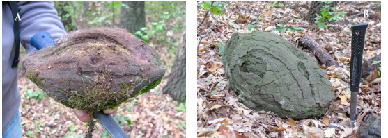
Figure 7. Spindle-shaped (A) and cracked (B) basaltic bombs at Bondoró
Columnar-Jointed Basalts
Columnar-jointed basalts are one of the most spectacular natural assets of the BBUGGp (Fig. 4D–E). They are often called here ‘basalt organs’ since erosion rounded the individual basalt columns, which are often separated forming tall ‘organ pipes’ (e.g. Badacsony, Szent György Hill; Fig. 8A–B). They represent lava lake rocks formed within the wide maar or tuff ring craters. Slow cooling results in polygonal cracking due to the contraction of the solid material. When the lava crops out due to subsequent erosion, the cracks slightly broaden through precipitation, wind erosion and temperature variation, i.e., freezing and thawing. The intermittent collapse of the tall and steep cliffs forms wide talus slopes at the foot of the lava rock bodies. Meanwhile, the fracture pattern in the basalt slowly transforms into columnar jointing. The columns have usually hexagonal and pentagonal shapes since these geometric patterns relieve the maximum stress per unit crack (Fig. 8C-D). Observations, numerical calculations and experiments show that the column diameter is dependent on the cooling rate (Toramaru & Matsumoto 2004; Goehring & Morris 2008; Hetényi et al. 2012). If cooling is slow, as we could expect in a lava lake, thicker columns are formed. This is what we can see in the exposed steep basalt bodies in Badacsony and Szent György Hill. In addition, we can often observe the regular repetition of cracks perpendicular to the columns. These are formed as the cooling front moves slowly down in the lava. They are called striae and their thickness also depends inversely on the cooling rate. As erosion is in progress, the basalt columns can be separated into large ‘basalt coins’ along the striae, as shown in the northeast part of Szent György Hill.
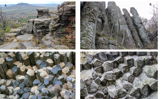
Figure 8. Variation for columnar-jointed basalts in the BBUGGp: A) Thick basaltic columns with striae (Badacsony with a view towards Szent György Hill; B) Tall (>10 m) basalt columns (‘basaltic organ’) of lava lake rocks of Szent György Hill; C) Cross section of mostly pentagonal basalt columns of lava rocks at Haláp; D) Cross section of the mostly pentagonal basalt columns of lava lake rock at Hegyestű.
Further spectacular columnar-jointed basalts are found at Hegyestű, Hajagos and Haláp. The columns are regularly pentagonal to hexagonal in shape, the most frequent column geometry of basalts (Hetényi et al. 2012). In Hegyestű, the regular columns of basalts (strictly, basanite) several tens of meters high attract visitors (Fig. 4E), which is why one of the visitor sites of the BBUGGp was established at that place. The columnar-jointed basalts can represent a solidified plug or a small lava lake, similar to those at Hajagos and Haláp, where the variably oriented jointing pattern can be also observed implying distinct lava flows within the crater (Fig. 4D). Effusive activity is confined mostly within the maar and tuff ring craters and no outpourings are observed. As these lava lake rocks are more resistant to erosion, a typical inverted volcanic relief was formed. The volcanic butte landscape of the Tapolca Basin is one of the most spectacular assets of the BBUGGp.
Monogenetic, Polycyclic, Polymagmatic volcanoes
In the Bakony–Balaton Uplands area, several volcanic structures show an eruption sequence from initial hydrovolcanic products through the scoriaceous material of the magmatic explosive phase to lava lake filling phase. This suggests a complex evolution of the basaltic volcanoes, not exactly fitting the picture of monogenetic volcanism (Németh et al. 2010; Németh & Kereszturi 2015). Monogenetic volcanism is commonly short-lived, characterized by a single eruption event, which forms a maar, a tuff ring or a scoria/cinder cone and is fed by a single batch of magma from the upper mantle. When distinct eruptive episodes are separated presumably for a longer volcanic episode, polycyclic monogenetic volcanism occurs (Németh et al. 2010) such as those represented by the Fekete Hill, Bondoró and Tihany volcanic complexes, although Badacsony and Szent György Hill could be also polycyclic. If a compositional change can be observed in the eruptive products, the volcanic activity is termed polymagmatic type (Brenna et al. 2010). Such changes were demonstrated in the small-volume volcano Kissomlyó in the nearby Kemenes Volcanic Field in the eastern segment of the Little Hungarian Plain (Jankovics et al. 2015), although the volcanic activity of the Fekete Hill could be also polymagmatic (Jankovics et al. 2019), where basaltic magmas with distinct compositional character were involved in the eruption stages. These polycyclic and polymagmatic eruption styles imply short pauses during the eruption event, which can be an important feature of monogenetic volcanism, since it suggests the potential for rejuvenation of volcanic activity after a shorter or longer break.
Fragments from the Upper Mantle
The boundary between the Earth’s crust and mantle is well below the depth that can be reached by drilling techniques. Many people think that the crust is underlain by molten material, although there is strong evidence from seismic and experimental studies that the mantle, the most voluminous part of our planet’s interior, is entirely solid. Magmas can be generated only in the uppermost part of the mantle and the ascending magma occasionally incorporates a variable amount of rock fragments from the rigid part of the upper mantle (this is part of the lower lithosphere). These rock fragments, called xenoliths (foreign rocks trapped in the magma; Fig. 6A) provide an invaluable insight into the nature of the mantle and therefore have great scientific value. Scientists have a unique opportunity to perform direct studies on these rocks and they can reveal the mineralogy, petrology and chemical composition of this unattainable part of the Earth and can indicate what processes occur there. As a result, we know that the lithology of the upper mantle is peridotitic, i.e., the prevailing rocks contain more than 40 vol% of olivine (high-Mg silicate mineral) and in addition two types of pyroxenes.
The basaltic magmas erupted in the Bakony–Balaton Uplands Volcanic Field often carried smaller and larger pieces of upper mantle-derived peridotite xenoliths. Antal Embey-Isztin and his co-workers were the first to conduct detailed studies (Embey-Isztin 1976a; 1976b; Embey-Isztin et al. 1989; 2001; Downes et al. 1992), and this pioneering work was followed by further studies, especially by Csaba Szabó’s group on the xenoliths collected at Szentbékkálla, Bondoró and Szigliget (e.g., Falus et al. 2000; 2007; 2008; Bali et al. 2002; 2007; 2008; Szabó et al. 2004; Hidas et al. 2007; Ntaflos et al. 2017). These studies revealed the nature (texture, mineral and chemical compositions, equilibration temperature and pressure, metasomatic events and reaction processes) of the lithospheric mantle rocks in a continental rifting area. These scientific studies and their wide dissemination have made this area famous for mantle-derived xenoliths and increased their natural values. The geoheritage importance and the unique scientific value mean, however, that these localities need to be protected and particularly, the collection of the peridotite xenoliths by visitors should be controlled. Therefore, explanation panels note that “Find it, take a photo at the outcrop, but please do not collect it!”
Basaltic Pyroclastic Flow Deposit
Pyroclastic flow is the most devastating volcanic eruption process. It is a type of density current when a mixture of rock fragments, volcanic ash and hot gases move fast along the ground under gravity, traveling tens or occasionally hundreds of kilometers (Dufek et al. 2015). There is a wide range of pyroclastic density currents, including pyroclastic flow with considerable amounts of rock and ash, and pyroclastic surge with a large amount of gas and thus of lower density and moving turbulently. Pyroclastic surge is often associated with hydrovolcanic eruption, when hot magma and water interact resulting in a violent explosive eruption. It spreads radially from the crater similar to the ground-hugging blasts during nuclear explosions (Moore 1967; Waters & Fisher 1971). Its deposits reflect the turbulent transport, i.e., show cross-stratification structures (beautiful examples can be observed at the Barátlakások sections on the Tihany Peninsula; Fig. 5C), which help to determine the direction of the transport, i.e., the vent source. The denser pyroclastic flows occur much more rarely during basaltic volcanic eruptions but are common during explosive eruptions of silicic magmas.
In the BBUGGp, a rare example of pyroclastic flow deposits related to a maar-type eruption of basaltic magma is found in the northern outskirts of Szentbékkálla village (Fig. 6). Németh & Martin (1999b) described it as a hydroclastic flow since, according to their studies, it contains a high amount of glass shards in addition to the abundant lithic clasts, typical of hydrovolcanic eruptions. It was formed by the collapse of an eruption column due to the high content of heavy lithic clast material. The massive volcaniclastic deposit contains gas segregation channels (Fig. 6B), a characteristic feature of pyroclastic flows, but again, a very rare example related to basaltic volcanism. These gas segregation pipes contain typically larger-sized clasts, usually lapilli, while the fine-grained fraction is missing. This is due to the elutriation of fines during the bypass of gas through the pyroclastic deposit. Presumably, the pyroclastic flow was channeled by a valley housing a small river and after burial by volcaniclastic material, the steam generated by the heated water migrated upwards through the loose deposit transporting the fine ash fraction. These unique volcanological features, along with the abundance of lithic clasts representing almost the entire lithosphere (Fig. 6A), including the upper mantle, give this locality high natural value and make it an important element of the volcanic geoheritage.
Magma–Sediment Interactions
A specific rock-type called peperite is formed during mixing between magma and wet fine-grained sediment at shallow depths, such as in the feeder dykes of the volcanoes (Busby-Spera and White 1987; Martin & Németh 2007). The area of the BBUGGp was partially covered by smaller and larger lakes just before volcanism, where lacustrine siliciclastic sediments accumulated. They were still partly unconsolidated and wet when magma bodies ascended and fed volcanic eruptions. Magma lobes intruded into the sediments and mingled (a mixing process without homogeneous hybridization of the two end-member materials), forming blocky and fluidal peperite textures. Since post-volcanic erosion removed large parts of the volcanic edifices and the root zones of the volcanoes have been nicely exposed, the BBUGGp offers an excellent area, where such magma–sediment interaction and peperite structure can be studied. They are recovered from abandoned quarries, which are partly protected and used to display to the public.
The best examples of blocky peperite can be observed at the Hajagos quarry, a geosite prepared for designation as a key section, where they are mostly around the basaltic feeder dykes (Martin & Németh 2007). The mixture of dark angular basalt clasts and yellowish-brown sandy sediment fragments gives a striking aspect to this kind of peperite. In addition, large peperitic bubbles were also formed when the hot magma invaded the highly wet shallow sediment and lava covered the swampy crater floor. This caused vaporization, bubble formation and updoming of lava flows (tumuli structure). At Hajagos, unique cross-sections of this phenomenon are preserved in the abandoned quarry walls. Fluidal peperite with rounded, pillow-like basalts in sediments is displayed at the margin of the columnar jointed basalts at Hegyestű and Haláp.
Volcanism from the Source To the Surface
Volcanic activity is just the surficial expression of a complex suite of processes. It starts in the upper mantle, where partial melting occurs and forms basaltic magma. It is followed by melt segregation and upward ascent through the rigid lithosphere. Most mantle-derived magmas accumulate at the crust–mantle boundary where magma batches periodically mix with each other and form a hybrid, variously evolved magma body. However, there are examples where mafic magma penetrates the lithosphere rapidly and reaches the surface within days (Harangi et al. 2013; Jankovics et al. 2013). Understanding these processes is key to forecasting future volcanic eruptions and how the population can be prepared for them. The volcanic eruption itself is controlled by several factors such as the physical and chemical properties of the ascending magma, the hydrogeology of the area and the shallow basement sedimentary sequences. Explosive and effusive eruptions have different societal impacts and therefore there is an increasing interest in better understanding these processes.
The BBUGGp offers a unique area where basaltic volcanism in a monogenetic volcanic field can be understood from the source to the surface (Martin and Németh 2004; Harangi et al. 2015; Smith and Németh 2017; Harangi 2019). The solid knowledge from extensive scientific research makes this region unique and increases its natural and geoheritage assets. Geoconservation helps to recognize and protect the particular and sometimes delicate natural heritage and transfer scientific knowledge to geoeducation and geotourism activities. The BBUGGp has made a great effort to widen the geoeducation and geotourism tools such as establishing new thematic nature trails and developing exhibitions in the visitor centers.
From Science to Geoeducation
Thematic Volcano Routes
There is a vast amount of gorgeous volcanic heritage in the area of the Bakony–Balaton UNESCO Global Geopark, comprising almost all the phenomena characteristic of basaltic volcanic eruptions. Within the framework of the Interreg Danube GeoTour project, two former nature trails were renewed and a new volcanological trail was established along more than 35 km (Fig. 9). Altogether 31 new interpretive panels were placed along the trails to get an insight into these spectacular processes in the area. The nature trail stops were designed to cover a wide range of volcanological features from the source to the surface and integrate them with cultural and historical heritage, as this kind of holistic approach is key for UNESCO Global Geoparks. In addition, another 2 km long volcanological trail was created in Halom Hill, across an eroded 4 Ma basaltic volcano (Futó et al. 2015). The formation of scoria and cinder cone is explained here with miniature volcanoes built from local volcanic rocks. On top of the hill is an abandoned quarry that exhibits the typical volcanic products of a spatter cone. From there, there is a “time path” along 500 Myr of the geological history of the area. A “volcano time wall” explains the temporal evolution of the basaltic volcanism next to a stone map with the contour of Lake Balaton and the locations of the basaltic volcanoes.
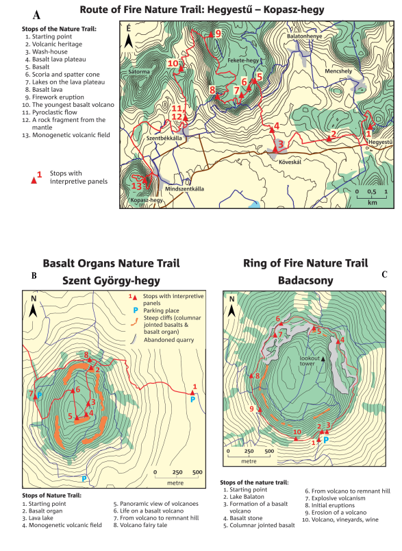
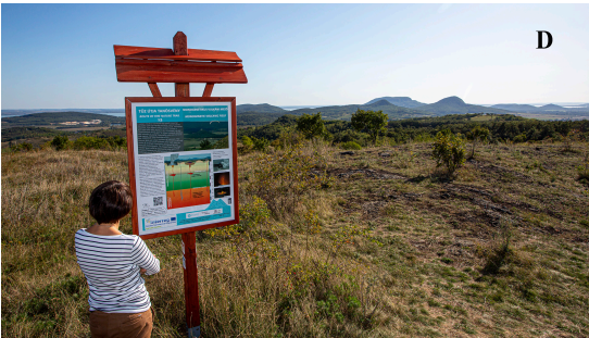
Figure 9. A) Map and stops of the Route of Fire Nature Trail; B) Map and stops of the Basalt Organs Nature Trail; C) Map and stops of the Ring of Fire Nature Trail. D) The last stop of the Route of Fire Nature Trail at Kopasz Hill with a spectacular view of the basalt remnant hills of the Tapolca Basin.
There are many experiences of how nature trails with explanation panels work and how they can attract visitors. The principal concept of the new volcanological trails and the interpretive panels was to explain as concisely as possible both in Hungarian and in English, and with a small number of spectacular photos and other figures. Each panel contains a question related to the given topic and a QR code, where the answers can be found. Furthermore, the QR code leads to a link where additional short information is given such as a short video showing attractive footage about the volcanic process.
The new nature trail is called the Route of Fire and guides the visitor from Hegyestű to Kopasz Hill with 13 stops (Fig. 9A) that include the Boncsos Hill with the proximal Strombolian to Hawaiian eruption products. This was previously an inaccessible abandoned quarry covered heavily by vegetation; however, a local association’s dedicated volunteers regularly remove vegetation at this geosite thus opening it for geotourism and geoeducational purposes. There is a stop also at the unique lithic-rich pyroclastic flow deposit and at the youngest volcano of the area (Füzes-tó/Kopácsi Hill), where abundant ultramafic xenoliths and fusiform bombs can be found. There is also a stop where the visitor can get information about an old, traditional washhouse, a unique building found only in this region of Hungary, where women of the village used to wash their clothes. Local streaming of the main karst-water system of the Bakony Mts is also shown here. At the last stop (Fig. 9D), there is a spectacular 360° view towards the volcanic buttes of the Tapolca Basin and the Káli Basin. Here, there is a summary explanation of the nature and dynamics of monogenetic volcanic fields.
The Basalt Organ Nature Trail (Fig. 9B) provides an insight into the formation of the famous basalt organs of the Szent György Hill that represent a remnant of a lava lake filled a wide crater of a tuff ring. This nature trail gives a challenging tour, revealing the nature of lava lakes and, the life and destruction of a basalt volcano in a monogenetic volcanic field. Visitors can find answers also about the oldest lava lake on Earth, how lava lakes are formed and which lava lake was discovered by the famous French volcanologist, Haroun Tazieff. Remarkable footage in the QR code links travel several million years back in time and shows how this area looked when fireworks and lava lakes of active volcanoes made the sky red at night.
Another famous volcanic remnant hill is Badacsony, next to Szent György Hill. The nature trail runs around the circle-shaped volcano, termed the Ring of Fire Nature Trail (Fig. 9C) with an additional option to walk to the lookout on the top. There are ten stops with information not only about the life and history of a complex basaltic volcano but also about how Lake Balaton was formed, the quarrying of the basalt stone and of course the close relationship between the volcano, vineyards and wine. Volcanic soils have many unique physical properties, but this is not enough for good wines; what makes these wines unique is the spiritual link between the people and the volcano. Balaton Uplands has had a long tradition of wine production for about 2,000 years, since the Romans (Szabó & Závodi 2018). The rows of vines along terraces provide a special atmosphere in Badacsony, and the most typical examples are at Kéknyelű, Szürkebarát, Olaszrizling and Tramini. However, the visitor can learn also about magma generation and why a volcano is right here and what is the temperature in the upper mantle. In the northern part of Badacsony, there are several large, abandoned quarries from which the basalt was used to build many houses, cellars and churches in this area. Open cast mining at Badacsony began at the end of the 19th century and by the 1930s, the Badacsony quarries yielded the largest production of basalt in Hungary. Environmentalists protested against the quarrying since the beginning and both quarries were finally closed by 1964. The quarrying revealed that beneath the lava rock, there are approximately 5-m-thick pyroclastic layers formed by explosive eruptions.
The Hegyestű Geological Visitor Site
One of the most visited volcanic sites in the BBUGGp is the Hegyestű (Fig. 1), where quarrying left a remnant of a former lava lake basalt exhibiting spectacular columnar jointing. There is a gorgeous 360° view from the top of the basalt (actually, basanite) columns to Lake Balaton, to the Káli Basin with the Fekete Hill lava plateau and in clear weather even to the basalt buttes of the Tapolca Basin. This is indeed a kind of ‘gatekeeper’ to introduce the Bakony–Balaton Uplands Volcanic Field. Thus, the Route of Fire Nature Trail starts here and in addition, a major reconstruction of this kind of recreation place. The old exhibition was renewed in the old mining building (Fig. 10A-C) to show how a monogenetic basalt volcanic field worked and how volcanic heritage meets local culture and the quarrying activity last century. Using modern technologies, visitors are attracted by a lava fountaining eruption with a small lava flow in a short movie (Fig. 10B; the 2021 Fagradalsfjall eruption in the Reykjanes Peninsula, Iceland; with the kind contribution of the Reykjanes UNESCO Global Geopark) onto the 3D model of a spatter cone (formulated also from the spatter cone formed during the 2021 Fagradalsfjall eruption). In a separate small room, visitors can experience the atmosphere of bubbling lava lake activity and the firework eruption of Etna (Italy) and the 2021 Fagradalsfjall eruption (Fig. 10C).
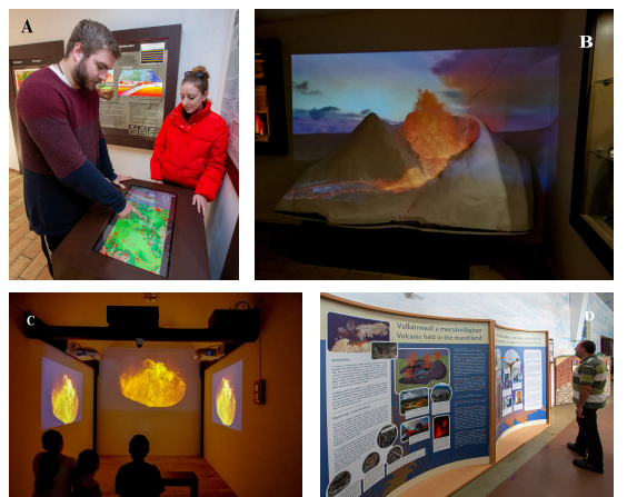
Figure 10. A) Interactive exhibition of the Hegyestű Visitor Centre; B) Hawaiian lava fountaining eruption projected onto the 3D model of a spatter cone; C) Enjoying the atmosphere of bubbling lava lake activity; D) Summary table about the life in the basalt volcanic field at the BBUGGp (Tihany Levander Visitor Centre)
From Lake Balaton towards the north, up to the town of Komárom (where the largest recorded earthquake occurred in Hungary in 1763, estimated to be M 6.2–6.5; Varga et al. 2021) is the area with the greatest seismic hazard in Hungary (Koroknai et al. 2023). Several other notable and destructive earthquakes occurred here during the past centuries. Therefore, the exhibition includes an earthquake corner with all the relevant information on why such quakes occur, how they can be detected and where the largest earthquake happened in Hungary. There is also an explanation of how people should respond during an earthquake. An old drum seismograph is also shown, thanks to the kind contribution of the Kövesligethy Radó Seismological Observatory. Touch screens help to introduce the geosites of the BBUGGp and other geoparks of the Danube area.
Other Tourist Facilities and Activities Presenting the Volcanic Heritage
Hungary’s most visited show cave is the Tapolca Lake Cave, where annually about 150,000 visitors not only enjoy the experience of underground boating, but where a large visitor center presents the geological evolution of the area. Although the exhibition is entitled “The Wonderful Karst” and focuses primarily on karst phenomena, the geopark room also presents the rich volcanic heritage of the Tapolca Basin (Fig. 11A), with a focus on the remnant hills and their emblematic geosites that are the main feature of the nearby landscape.
A popular tourist destination on the Tihany Peninsula is the Lavender House Visitor Center (Fig. 10D), which not only presents the traditional cultivation and processing of the fragrant plant, but also the dynamic geological past of the area, e.g. the first volcanoes of the Bakony–Balaton Uplands Volcanic Field that erupted in the late Miocene, about 8 Ma. Visitors are attracted by how a bomb-sag is formed in soft, wet sediment and how a maar-volcano is formed. A short movie takes people back to the time when active basaltic volcanoes made the night sky red and how they subsequently eroded to become remnant hills. The interactive exhibition also includes a large panel showing the UNESCO Global Geoparks of our planet, which have unique volcanic heritage.
Every year, the staff of the Balaton Uplands National Park Directorate and the certified partners of the geopark offer many guided geotours in the volcanic areas, which are undoubtedly the most popular outdoor programs of the geopark, due to the impressive level of geodiversity and the scenic beauty (Fig. 11B-C).
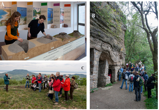
Figure 11. Active indoor and outdoor activities in the BBUGGp: A) Models show formation of the basalt remnant hills (Tapolca visitor centre); B) Guided geotour in Tihany (Barátlakások); C) Guided geotour on the top of the Szent György Hill with a few to the Badacsony (C).
The BBUGGp provides a rich geotourism offer to a wide spectrum of people who are interested in geological processes and the spectacular geological phenomena of the geopark. The extensive scientific research has confirmed this area among the most renowned volcanic areas on Earth and enabled transfer of this knowledge to geoeducation and geotourism in various ways.
Acknowledgments
Development of the volcanological Nature Trails and the exhibition of the Hegyestű Visitor Centre was part of the project funded under the Danube Transnational Programme supported by the European Union Regional Development Fund and co-financed by the Hungarian State (http://www.interreg-danube.eu/danube-geotour). Careful and detailed reviews provided by Károly Németh and Márton Pál helped to improve the original manuscript.A