Introduction
Ecuador has a privileged geographic and geological location demonstrated by the great diversity of epeirogenic, petrographic and morphological events related to the displacement of the South American plate (Goossens 1970; Winckell 1997). The active geodynamic evolution between the Nazca and South American plates is the main tectonic and structural factor influencing geological dynamics at the local level (Baldock 1982; Ordoñez Obando 2012). These tectono-structural variables physiographically divide Ecuador into five geographic regions (Fig. 1) with contrasting morphologies: the coastal forearc region (CFR), the magmatic arc or Western Cordillera (WC), the internal hinterland segment of the fold-thrust belt or Eastern Cordillera (EC), the external frontal segment of the fold-thrust belt or Subandean Zone (SZ), and the Oriente foreland basin (OFB) (BGS-CODIGEM 1983; Aspden et al. 1987; Cediel et al. 2003; Berrezueta et al. 2021), all of them separated by structural segments dominated by active subduction (Nazca plate under South American plate); further to the west, on the abyssal plain, appears the Insular Zone or Galapagos Islands, formed by Quaternary volcanism (Geist et al. 2005, 2008). These blocks allow Ecuador to be subdivided into morphologically different geographical regions.

Figure 1. Tectonic-structural framework of Ecuador, from which the structural and geographical division of Ecuador is produced. Source: Berrezueta et al. 2021.
Continental Ecuador is on a large volcanic arc that overlies the Paleozoic crystalline basement (amphibolites, schists, gneiss, among others), and in some cases, is located on thick deposits of Cretaceous and Cenozoic sedimentary rocks (Baby et al. 2014; Bablon et al. 2020). Sumaco volcano is a conical stratovolcano 3,830 m high that emerges on Cretaceous sedimentary rocks and is one of the main geological elements of interest within the Ecuadorian Subandean zone (Colony & Sinclair 1928; Salgado Loza et al. 2021). The Subandean zone presents three very well-marked structural features: to the north the Napo Uplift, to the south the Cutucu Mountain Range, both separated by the Pastaza Depression (Hall 1977); the Napo Uplift being an elongated dome with an NNE-SSW orientation (Fig. 2), as a consequence of the thrust fault of the back-arc folding (thrust belt), developed mainly during the Mio-Pliocene and Quaternary (Baby et al, 1999; Barragán & Baby 2004). In this uplift, emerge rocks from the Cretaceous and Paleogene periods belonging to the eastern Ecuadorian basin.
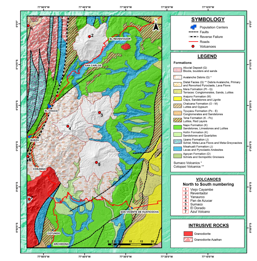
Figure 2. Geology of the Napo Uplift. Note the Sumaco Volcano (5) as one of the main volcanic elements of this tectonic structure. Source: Egüez et al. 2017.
The Napo Uplift is a positive structure that forms a updomed region and corresponds to one of the most important geological features in the eastern zone, with an extension of about 10,000 km2. This uplift expresses an unevenness close to 1.6 km concerning the Amazon Plain and obeys a block uplifted by a reverse fault system, limited to the west by the Guacamayos Fault and to the east by the Galeras Fault (Balseca et al. 1993; Paladines & Soto 2010).
All this great variety of geological scenarios and its location at the foot of the eastern branch of the Andes Mountain range comply with the indicated framework for the formation of the Sumaco volcanic edifice, whose petrographic characteristics of its effusive materials and its eruptive dynamics (Barragán & Baby 2004) make it an element of great geological interest. In addition, the Sumaco volcano is a typical and practical example that explains the connection between geodiversity and biodiversity (Alahuhta et al. 2018; Ren et al. 2021) since it is located in one of the regions with the greatest biodiversity on the planet (Kier et al. 2005; Dangles & Nowicki 2009). Its ecological diversity contributes to the formation of various climatic zones and important ecological zones, providing stories about montane forests, paramo (moorland), and cloud forests, among others (Cañadas 1983; Toulkeridis et al. 2009; Lozano et al. 2013).
Sumaco volcano is in the Sumaco Napo Galeras National Park (SNGNP) and corresponds to the core area of the Sumaco Biosphere Reserve (SBR), which covers an area of 931,930 ha. The SBR combines two ecoregions of global interest: the Amazon and the Northern Andes, encompassing ecological conditions that favor the provision of ecosystem services linked to biodiversity, landscapes, and various hydrological functions. Annual rainfall in the sector is around 2,000 and 6,000 mm (Ministerio del Ambiente, Agua y Transición Ecológica 2023), creating an important hydrological potential for the nascent hydrographic basins from the Sumaco volcano (Valarezo et al. 2001).
These details define why this geological site can be used for multiple tourist activities. For example, the development of community management of tourism in the Sumaco volcano is a powerful geoconservation tool. In this and other cases, Community Tourism Centers (CTC) have the role of guardians of the volcano, and the core area of SBR (SNGNP), and at the same time, their orientation and conservation activities mean an economic income for their families (Maldonado 2006; García Palacios 2016).
These conditions establish the appropriate framework for the management of geotourism activities at the Sumaco volcano, considering that geotourism is an activity that relates the tourist to the geology, geoforms, and landscapes of a territory, but also to be involved in the intrinsic connection of communities and their environment and ways of life (Hose 2000; Newsome & Dowling 2010; Dowling 2012; Newsome et al. 2012). In a complementary way, scientific dissemination at the local level has been strengthened with the development of the Napo Sumaco UNESCO Aspiring Global Geopark (NSAUGG), which has promoted community empowerment activities and the development of geotourism (Napo Sumaco Aspiring Geopark 2019; Geoparque Napo Sumaco 2023).
Methodology
The present work is an applied and descriptive investigation, developed from the survey of qualitative information in situ (Tylor & Bogdan 1986) with primary sources: direct observation in the field through routes to trails, visits to facilities and interviews with key actors, principally guides of community tourism of the CTC of the locality Pacto Sumaco and park rangers of the SNGNP. Considering that the questions asked were framed for the management of local tourism and geotourism interests associated with the Sumaco volcano, the selection of the interviewees was biased and directed towards five representatives of the Pacto Sumaco CTC (comprising 28 local guides), who are permanently in charge of tourism management in this area. This data was complemented with secondary information, described in documents, management plans and other available electronic sources.
The area of application of this work is the town of Pacto Sumaco and its area of influence, which includes 73 families, with an average of 350 inhabitants (Calderón et al. 2016). This town is essential for collecting information, bearing in mind that there are no towns within the national park, and Pacto Sumaco is the starting point of the Sumaco Volcano Interpretive Trail and the CTC. Field visits made it possible to visualize the condition and local structures linked to the infrastructure and potential elements for the development of geotourism, defined by geodiverse, biodiverse, and cultural interests.
Main Geotourism Interests Associated with Sumaco Volcano
Interests linked to geodiversity features
The Ecuadorian northeast has been greatly developed in terms of geological research, due to the exploration of oil and other mineral resources, resulting in detailed studies of the geology. Sumaco volcano is in this sector; it is a stratovolcano with a symmetrical cone and appears isolated from the other mountain ranges or other volcanic edifices (Ministerio del Ambiente 2011; Parque Nacional Sumaco 2023). The products from its eruptions are very dissimilar to those of any other Ecuadorian Andean volcano, being alkaline type lavas, mostly basanites and phonolites (Fig. 3), with the typical coloration of extruded basic material, a porphyritic texture with outstanding minerals of biotite, pyroxenes (mainly titano-augite) and hornblende (Barragán & Baby 2004; Garrison et al. 2018; Salgado Loza et al. 2021), in addition to the permanent presence of haüyne crystals, as a characteristic feature of the lavas of this volcano (Fig. 4). Haüyne is a rare mineral used commonly for commercial purposes, due the small size crystal and intense blue color (Tracy 2003). In Sumaco volcano, the local guides, although they had noticed the mineral before, did not treat it as important. This represents a notable difference from the other volcanoes of northern Ecuador, whose characteristic lavas are of basaltic and andesitic composition.
Barragán and Baby (2004), suggest that the different volcanic rocks generated by Sumaco volcano (mostly alkaline type) compared with other volcanic edifices in northern Ecuador indicate a volcanogenic limit, which separates a type of purely alkaline magma, consistent with the great contribution of materials coming from sedimentary rocks (mainly limestones). Rosenbaum et al. (2019), suggested that the geochemical anomalies of this volcano are related to rapid ascents of magmatic material from the mantle, involving tearing and rapid melting of the enclosing slab.
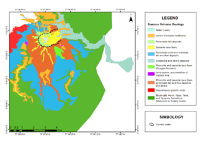
Figure 3. Sumaco Volcano Geology. Detail of the different geological materials of the Sumaco Volcano. Source: Toulkeridis et al. 2009.
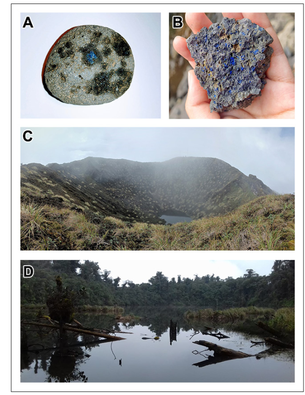
Figure 4. Images with elements of the geodiversity of the Sumaco volcano. A andB) basanites with haüyne blue crystals, characteristic mineral in the Sumaco volcano; C) summit of the Sumaco volcano in which a lagoon stands out inside its crater; D) Wawa Sumaco Lagoon, a paleo-crater of Sumaco volcano.
The volcanic alkaline rocks are one of the main attractions of Sumaco volcano and its dissimilar eruptive materials suggest that their explosivity indices have varied throughout the lifetime of this volcano, considering that it generated intense eruptions at the beginning of its activity, decreasing its intensity towards the present (Table 1). In fact, according to Toulkeridis (2013), in the past Sumaco volcano would have presented two types of Volcanic Explosivity Indices (VEI): 3 (Vulcanian) and 6 (Plinian to ultra-Plinian), these being the most common VEI values in these kinds of volcanoes (Newhall & Self 1982).
Table 1. Summary of data about historical eruptions of Sumaco volcano and Volcanic Explosivity Index (VEI). Although there is no written data on historical eruptions of this volcano, it is suggested that the most recent eruptions occurred between 1895 and 1933. Sources: Barragán and Baby (2004), Toulkeridis (2013), Garrison et al. (2018) and Global Volcanism Program, Smithsonian Institution (2023).
Start Date | Completion Date | Eruption Certainty | View | Evidence |
Unknown | Unknown | Uncertain | 6 | Paleo crater morphology, genesis of petrographic material, collapse of structures, pyroclastic flows. |
1650 ± 50 | Unknown | Uncertain | 3 | |
1895 ± 30 | Unknown | Confirmed | 2 | Historical observations |
February 1933 | Unknown | Uncertain | 2 |
There is evidence of these eruptive periods, for example, scars on the volcano that separate the different eruptive phases, which divide the crater of the Paleo-Sumaco (called Wawa Sumaco), and the Recent Sumaco (Salgado Loza et al. 2021). In the Paleo Sumaco, a lagoon has been formed and covers 1.8 ha, at approximately 2,470 m.a.s.l.; its edges are smoothed and with an almost circular outline, typical of volcanoes with a long rest period. On the slopes of this crater, it is possible to find pyroclastic material with a high degree of weathering that arose from environmental conditions linked to the presence of primary forests. All these exposed elements are important instruments for teaching the historical processes of the evolution of the volcano, from its genesis to the modeling of the landscape by biological and hydrological erosion.
Biodiversity and Ecosystem Services
According to the geodiversity adjacent to the study area, Sumaco volcano is perfect to make it a priority area for conservation at the national level (Cuesta et al. 2017). Key factors in the high level of endemism of this region are its geographical location (at the eastern end of the Cordillera Real, Napo Uplift), the isolated condition of the core area of the Cordillera Real, and its proximity to the Amazon basin (UNESCO 2019; Lozano et al. 2020; Camper et al. 2021).

Figure 5. Location map of Sumaco Napo Galeras National Park, which is the core area of the Sumaco Biosphere Reserve. The community of Pacto Sumaco is the gateway to the National Park and the summit of the Sumaco Volcano.
The core area of Sumaco Biological Reserve (SBR), which corresponds to the Sumaco Napo Galeras National Park (SNGNP) and which includes the Sumaco stratovolcano (Fig. 5), enjoys a large number of environmental services, which derive from the functions of the forest (generation and capture of water, vital support, capture of CO2, control of erosion, soil endowment, regulation of hydrological and biogeochemical cycles, landscapes and scenic beauty, among others), in addition to the richness of non-timber products (medicinal plants, ornamental, edible, industrial species, etc.) (Valarezo et al. 2001; Pronaturaleza 2021).
Toulkeridis et al (2009), indicate that the great biological diversity of transects within the interpretive routes of the Sumaco Volcano is linked to the ecological variety and climatic zones, among which stand out: montane humid scrub, evergreen montane forest, herbaceous paramo, montane cloud forest, cushion paramo, lower montane evergreen forest, montane lacustrine grassland, and montane evergreen forest (Fig. 6).
Figure 6. Sumaco Volcano contributes to the high ecological and biological diversity of SNGP. A) Highlight of the walking trail and the agricultural and livestock transition processes in the area of influence of the SNGNP, with the Sumaco volcano in the background; B) this sector is suitable habitat for the jaguar (Panthera onca); C) the ecosystems of the Sumaco, herbaceous paramos give way to the formation of epiphytic plants (Phlegmariurus hystrix); D) evergreen montane forest, one of the characteristic climatic floors of the Sumaco volcano.
Specialized investigations on the biological diversity of the SNGNP are limited, but basic information establishes that the Sumaco region has about 6,000 species of vascular plants in the different altitudinal zones, of which more than 90 species are considered endemic, 21 species of orchids and 8 of bromeliads (Valarezo et al. 2001; Almeida Vélez 2015; Ministerio del Ambiente, Agua y Transición Ecológica 2023).
The biogeographic conditions of the Sumaco have enabled the formation of altitudinal zonation and ecological niches that concentrate the fauna from the Andean and Amazon slopes (Toulkeridis et al. 2009). Geodiversity plays a valuable role in the development of biodiversity characterized by high endemicity and great biological diversity present in the study area. Among the characteristic fauna of the sector, 188 species of birds, 81 species of mammals, 58 species of snakes, 31 toads and six turtles have been reported. Iconic species of the area (Stattersfield et al. 1998; Grefa 2006; Játiva Zambrano 2019) include the jaguar (Panthera onca), the cougar (Puma concolor), the tigrillo or ocelot (Leopardus pardalis y Leopardus wiedii), the spectacled bear (Tremarctus ornatus), the tapir (Tapirus pinchaque) and the spider monkey (Ateles belzebuth).
Cultural and Historical Interests
Among the historical aspects related to this colossus, it is possible to mention that the first settlers of the sector near the Quijos Valley, in their daily lives, considered the Sumaco as a magical and mystical element (Gutiérrez Marín 2002). Many travelers, visionaries, scientists, and thinkers were amazed at its majestic appearance (González Suárez 1901). The name “Sumak” (a term of Kichwa origin) evokes beauty, loveliness, and majesty since its view from a distance is majestic. Despite the representativeness of the name Sumaco for the kichwa speaking peoples around this volcano, other names have been given by visitors. Many knew it as the "volcán de los Guacamayos" (The Macaw volcano in English), alluding to its proximity to the Guacamayos Mountain Range. It was also suggested that the name Sumaco comes from the Spanish "Zumaco", because the first explorers found it, leaves like other leaves already present in Spain, called "Zumaque.”. This plant in Spain was known as “La Coca”, and for this reason many called Sumaco the "Volcán de la Coca,” the Coca volcano (Jiménez de la Espada et al. 1998).
The attraction of this volcano seduced visitors, who not only wanted to see it, but also to reach its summit. Thus, one of the most described and narrated ascents on the Sumaco, is given by the Pacific Expedition (planned since 1860 and carried out from 1862 to 1865, to explore and visualize possible cinnamon trees in the Ecuadorian Amazon). This expedition was characterized by being one of the most modest in comparison with English, French and North American scientific expeditions. In addition, it arrived in Ecuador at a time of important reforms against a strong-handed government headed by Gabriel García Moreno. According to Jiménez de la Espada (1892), his ascent to the Sumaco volcano was on June 19th, 1865, following a tortuous and long road, from what is currently the city of Loreto. Jiménez de la Espada (1892) claims that even Humboldt was impressed with the bellows of the Sumaco that were heard in the distance in the Valle de Los Chillos. The British George Dyott is another of the most renowned explorers who reached the top of the colossus in 1925.
Don Pedro Ordoñez de Cevallos (1691) referred to Sumaco, as a volcano in the form of a "sugar loaf", whose power can cover everything in its vicinity with ashes within a perimeter of two leagues. He even mentioned that since then "many Indians have visited his mouth". In his book, the author also recounts his surprising experience, when, on his ascent to Sumaco, he meets a Cofán sorcerer in the crater of the volcano, who according to his account, had come there to be able to speak with "the devil" (Ordoñez de Cevallos 1691).
Changing environmental conditions have encouraged new settlers who live next to the volcano. Currently, the community of Pacto Sumaco is a settlement located in the sector because of migration. On March 5, 1987, almost a thousand people died because of two large earthquakes (6.1 and 6.9 on the Richter scale). The epicenter was located next to the Reventador volcano, causing substantial human and economic losses, and people at risk there were transferred for security reasons. Pacto Sumaco is part of these communities relocated after the disaster (Hall 1991).
After a difficult process in search of the social and economic revival of a few families transferred to the sector, help appeared from a religious group called "Pacto Evangélico". This group provided help to the displaced and relocated residents with supplies and food. In gratitude for the assistance received, the new settlement that would house them, since then was called "Pacto Sumaco" in honor of their benefactors. At present, Pacto Sumaco is a community of approximately 73 families, which are dedicated mainly to agriculture and to a lesser extent livestock.
Administrative Structures and Community Management for the Development of Geotourism
Administrative Structures for Conservation
The areas around the Sumaco volcano, and the subandean foothills in general, have been considered of national importance for their marked ecosystem and biological diversity. It is for this reason that, as of March 2, 1994, under resolution 009 and as recorded in Official Gazette 471 of June 28, 1994, a total area of 205,249 ha that includes the Sumaco volcano, Cerro Negro volcano, Pan de Azúcar volcano and Galeras mountain range (Fig. 2), became administratively recognized by the Ecuadorian government as a natural conservation area under the name of the Sumaco Napo Galeras National Park (SNGNP) (Valarezo et al. 2001). The SNGNP is part of the Sumaco Biosphere Reserve (SBR), whose protection context has a more extensive and international profile. The SBR was consolidated on November 10, 2000, and promoted by the German Technical Cooperation Office (GTZ, for its acronym in German) (Ministerio del Ambiente 2011; UNESCO-MAB 2014).
By national environmental legislation, the conservation area is protected by conservation instruments and the National System of Protected Areas (SNAP, for its acronym in Spanish). National Parks are characteristic elements of conservation in Ecuador, in which extractive and occupational activities are restricted, although the development of educational, scientific and recreational activities is allowed, promoting the maintenance of the pristine natural conditions of the natural heritage (Columba 2013; Código Orgánico del Ambiente 2017). Protected areas of Ecuador belong to SNAP, and therefore the Ministry of the Environment, Water and Ecological Transition (MAATE for its acronym in Spanish), which serves as the governing authority for compliance with conservation policies in force to date (Columba 2013; Código Orgánico del Ambiente 2017; Sandoval-Salazar 2021).
Napo Sumaco UNESCO Aspiring Global Geopark, covers approximately 13.5% of the province of Napo and covers approximately 1.800 km2. NSAUGG is based in the Amazonian mountainous region and consists primarily of irregular slopes; hilly and mountainous systems; mesas; plateaus; valleys; terraces, in Mesozoic and Cenozoic sedimentary rocks, and Quaternary volcanic rocks. The altitude ranges from 3,830 m.a.s.l., at the top of the Sumaco volcano, and 400 m.a.s.l. in the confluence zone of the Misahualli River and the Napo River.
Sumaco volcano is one geosite of the Napo Sumaco UNESCO Aspiring Global Geopark, which, despite not being an entity protected by SNAP, has taken center stage in community and management aspects (Napo Sumaco Aspiring Geopark 2019). In addition, as of December 21, 2021, in the Official Gazette No. 602, the National Assembly of Ecuador approves the Organic Law Reforming the Organic Code of the Environment and the Organic Code of Territorial Organization, Autonomy and Decentralization, in which the Republic of Ecuador establishes that geoparks must be included in the national territorial planning processes, aimed at planning and developing the rights of nature, geology conservation, environmental prevention and recovery of degraded natural spaces (Ley Orgánica Reformatoria del Código Orgánico del Ambiente y del Código Orgánico de Organización Territorial, Autonomía y Descentralización 2021).
Community and Participatory Management
Within the framework of the participatory management of tourist activities at a national level, the Ecuadorian Tourism Law establishes that tourist activities may be initiatives developed from community structures and that the State will participate in fostering and promoting tourist products, that are competitive (Ley de Turismo 2002); in addition, the creation of Community Tourism Centers (CTC) is provided as a management mechanism in which local communities take advantage of their assets, guaranteeing community participation and the sustainability of the resource (Reglamento para los Centros de Turismo Comunitario 2010). Likewise, the SNGNP management plan contemplates a local tourism subprogram (besides conservation strategies, communication, environmental education, and waste management, among others), which establishes the need to have the participation of the community for the development of tourist activities within the park, to create community economic benefits, while the community participates in the conservation of the natural elements of the park and the maintenance of the existing infrastructure (Ministerio del Ambiente 2011).
With this background, the community of Pacto Sumaco, in collaboration with the German Technical Cooperation Office (GTZ), and as part of the "Gran Sumaco" protection project, created a local tourism management structure called the "Pacto Sumaco Community Tourism Center", to organize visits to the Sumaco volcano, plan the guides available to accompany visitors on the tours and support the maintenance of the tourist infrastructure.
As part of the co-management structure, the SNGNP has trained nature guides to work as tour operators within the national park, issuing licenses for them (Fig. 7). Currently there is a contingent of 28 nature guides and the main tourist product is a guided visit to the Sumaco volcano. Although not all inhabitants of this community participate directly in the CTC (the main productive activities of the community are the cultivation of naranjilla, palm, and Sumaco mushrooms and the extraction of wood), however, there is a strong community commitment towards sustainability from alternative development strategies.
Figure 7. Geotourism activities at Sumaco park. a) Training of community tourism guides of the CTC Pacto Sumaco, carried out by the team of Napo Sumaco UNESCO Aspiring Global Geopark; b) CTC Pacto Sumaco Visitors Center, a space intended for the reception of tourists and a refuge for guides and park rangers.
Infrastructure for the Development of Geotourism
In general, the state of conservation of the SNGNP has remained in exceptional state due to its geographical location isolated from large urban centers, although this has meant limitations and difficulties in access to the volcano. Despite these limitations, the provisioning available in this conservation area is quite comfortable and functional for the visitor who seeks a totally natural experience.
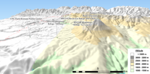
Figure 8. 3D image of the walking trail to Sumaco volcano, from the community of Pacto Sumaco. Note the level of difficulty, related to the slopes, from the Refuge "Mirador".
From the closest approaches to the volcano, it is possible to find an Environmental Communication Center run by the Ministry of the Environment, Water and Ecological Transition (located in the Guagua Sumaco community) and a visitor service center run by the CTC Pacto Sumaco (located in the community of Pacto Sumaco). In addition, the CTC Pacto Sumaco has community rooms for lodging. The ascent to the Sumaco volcano starts from the community of Pacto Sumaco, following an 18.5 km path, with signage and information for the visitor (Fig. 8). Along the path of the trail there are rest areas and three shelters equipped with kitchens, bathrooms, and accommodation spaces (Table 2).
According to information provided by the CTC Pacto Sumaco, there is an average of 300 tourists per year who enter the SNGNP (Walking trail Sumaco volcano), and who spend between 120 and 150 USD for the three-day tour, all included. Of course, throughout the tour, tourists can enjoy views and landscapes related to natural elements present in the area: Wawa Sumaco Lagoon, the Mirador, epiphyte forest, monkey forest, community forest, among others (Ruíz Álvarez 2010; Játiva Zambrano 2019). It is worth emphasizing that the trail is not self-guided, it is always necessary to hire the services of a local guide from the CTC Pacto Sumaco. Table 2 shows details of the distances between each refuge.
Table 2. Infrastructure presented on the route to the Sumaco Volcano. This equipment is overseen by the CTC Pacto Sumaco.
Infrastructure | Description | Current State |
CTC Pacto Sumaco Visitors Center | The building located in the community of Pacto Sumaco, which is used as a visitor reception center, kitchen room, meeting place, and shelter for park rangers and local guides (Fig. 9). | Excellent conditions and equipment. |
Lodging cabins Pacto Sumaco | An infrastructure built at 790 m from the Pacto Sumaco town center that belongs to the Pacto Sumaco CTC. Currently, the cabin can accommodate eight people in its two rooms, equipped with beds and bathrooms. It is especially visited by students, mountaineers, and backpackers. | Very good condition, permanent maintenance by members of CTC Pacto Sumaco. |
Walking Trail Pacto Sumaco – Sumaco volcano | Walking Trail with a length of 18.5 km towards the summit of Sumaco Volcano. The path has two sectors: the palisade sector (2.8 km) and the second section (16.1 km). The trail up to the volcano is highly complex because of dense vegetation, permanent humidity, and steep slopes (Fig. 8). It is done in an average of 15 hours (one way), spending the night in one of the shelters (La Laguna Wawa Sumaco) and a 3-day visit is required to complete the tour. | Good condition, members of CTC Pacto Sumaco maintain the trails, but the harsh environmental conditions make work difficult. |
Mountain Refuge “Mirador” | Located in the area called "El Mirador" at km 6.8 and at 1,760 m.a.s.l. It does not have electricity and water is obtained by collecting rain in plastic ponds. It has two rooms (one with bunk beds for 10 people and another for 4 people), kitchen (with gas stove and cooking utensils) and an area with a toilet. It has a privileged view of the Sumaco Volcano (Fig. 9). | Very Good condition, periodically maintained by members of the CTC Pacto Sumaco. |
Mountain Refuge “La Laguna Wawa Sumaco” | Located at km 12.35 and next to the Wawa Sumaco Lagoon, at an altitude of 2,500 m.a.s.l. This refuge has two rooms (one with bunk beds for 12 people and the other with a capacity for 6 people), it has an area with a toilet, a kitchen with a gas stove, kitchen utensils, and a rainwater collection system, which is stored in two plastic tanks. This refuge is the best equipped of all and has two viewpoints: one to the Wawa Sumaco Lagoon and the volcano, and the other to the Galeras hill. | Very Good condition, periodically maintained by the members of the CTC Pacto Sumaco. |
Mountain Refuge “Pava Yaku” | Located at km 15.03, in Pava Yacu sector, and at an altitude of 2,760 m.a.s.l., it has a room with the capacity to house 10 people, which is shared with the kitchen (the kitchen has similar conditions as the other refuges). It also has a bathroom and a rainwater collection system. Due to its distance, this refuge is not used to spend the night, but as a rest area during the ascent to the volcano. | Good condition, refuges are maintained periodically by members of the CTC Pacto Sumaco, but this refuge is rarely used for overnight stays. |
Rest areas on Walking Trails | Three rest areas are located along the trail to provide shelter, rest and food. These are simple constructions, being rectangular areas of 24 m2 (6 m x 4 m) and covered with a zinc roof. They are located as follows: 1) km 5.27, at a distance of 1.23 km from the first refuge and at an altitude of 1,687 m.a.s.l.; 2) km 9.37, at an altitude of 1,770 m.a.s.l.; and 3) km 10.93, at an altitude of 1,812 m.a.s.l. | Good condition, rest areas are maintained periodically by members of the CTC Pacto Sumaco, but environmental conditions destroy the wood from which they are built. |
Signage on walking trails | Throughout the walking trail to the Sumaco volcano, there are signs with information related to the flora and fauna along the way. There are also signs indicating the distances to the refuges and the summit (Fig. 9). | Very good condition, periodically maintained by members of the CTC Pacto Sumaco. |
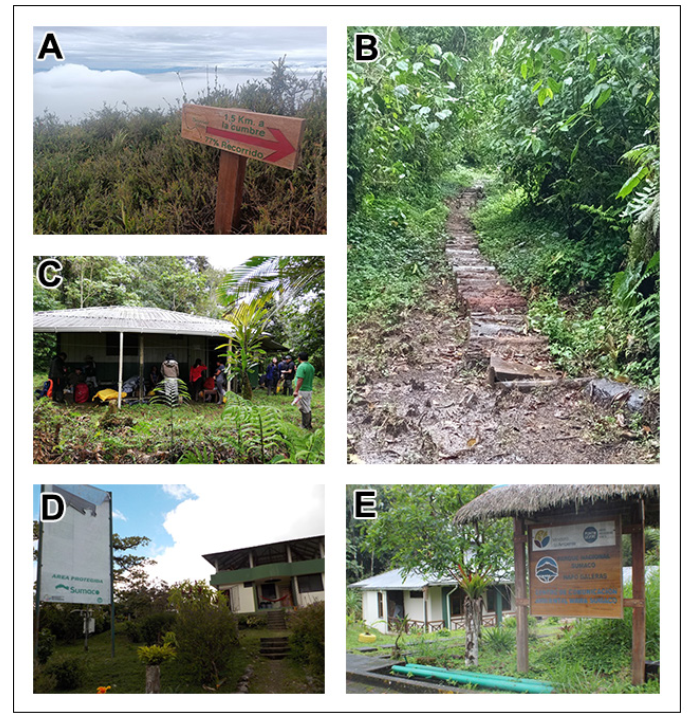
Figure 9. Accessible infrastructure for visitors to the Sumaco Volcano within the SNGNP. A) signage along the walking trail to the Sumaco volcano, which specifies the distances traveled; B) walking trail towards the Sumaco volcano, from the palisade sector (2.8 km); C) panoramic view of the “Mirador” Refuge; D) CTC Pacto Sumaco Visitor Center; E) Environmental Communication Center, located in the Guagua Sumaco community, an infrastructure overseen by the Ministry of the Environment, Water and Ecological Transition
Discussion
Geotourism is a sustainable productive activity that promotes and enhances the identity traits and heritage resources (natural and cultural) present in a territory and allows visitors to interact with the geology while learning about the culture and local traditions (Newsome & Dowling 2010; Dowling 2012; Newsome et al. 2012; Arouca Declaration on Geotourism 2017; Duarte et al. 2020). This transforms geotourism into a versatile and easily applied activity, capable of providing opportunities to improve the quality of life of a population while disseminating scientific knowledge (Hose 2000; Duarte et al. 2020; Štrba et al. 2020).
The unique geological conditions of Sumaco volcano, as well as its various interests (geodiversity, biodiversity, cultural and historical heritage), are all appropriate for developing strategies for geotourism. Sumaco is like many other unique sites around the world that show volcanic heritage (Fepuleai et al. 2017, 2021; Németh et al. 2017; Németh & Gravis 2022; Németh 2023). Volcanic areas have unique conditions as well as high geodiversity that is globally attractive (Dóniz-Páez 2022), and traditionally these areas have been used for geotourism, adventure tourism and other outdoor activities (Erfurt-Cooper 2010, 2011).
UNESCO (2017) and GGN (2022) recognized that territories with valuable heritage and sustainable development strategies can be recognized as global geoparks, considering that a geopark is a geographic space with areas whose landscape has geological elements of international significance, managed from a holistic concept of protection and education. With this prelude, the Sumaco volcano is the emblematic geosite of the Napo Sumaco Aspiring UNESCO Global Geopark (NSAUGG), and local communities and their natural and cultural heritage are part of this proposal (Napo Sumaco Aspiring Geopark 2019). Besides, NSAUG is currently an IDAs site (Internationally Designated Areas) from its designation as a Biosphere Reserve. The application as a UNESCO Global Geopark opens the possibility of consolidating as a MIDAs site (Multi-Internationally Designated Areas) (Schaaf & Clamote Rodrigues 2016).
Considering that geotourism promotes culture and dissemination of local traditions, makes it an activity that necessarily involves the participation of communities (Mukwada & Sekhele 2017; Matshusa et al. 2021), and in many cases has a positive impact on society (Fitri et al. 2020). In this sense, both the training and planning activities, as well as the geotourism development actions carried out by the Pacto Sumaco CTC tour guides in the Sumaco volcano, support the intrinsic potential of local communities in this territory.
Although Stoffelen & Vanneste (2015) indicate that ideal natural and cultural conditions may exist to develop geotourism, if there is a lack of inclusive governance and adequate territorial work networks, the efforts will tend to dissipate over time. In the tourism management of the Sumaco volcano and the Sumaco Napo Galeras National Park, interesting synergies have crystallized through multifunctional management structures, based on the assignment of powers and responsibilities. For example, on the one hand, the Ministry of the Environment, Water and Ecological Transition of Ecuador grants tourism concessions to the community adjacent to the buffer zone for its usufruct (the zone of land around the geopark where legal rights to land use exist), in addition to the provision of economic means in accordance with the budgets, and the communities execute the agreements and commitments of usufruct and conservation, as well as protection, research and monitoring programs (Muñoz Barriga 2014, 2017). In addition, the German Technical Cooperation Office (GTZ) has generated initiatives financed for the improvement of infrastructure and strengthening of local capacities for the reception of visitors.
The participation of geoparks is fundamental for the local management of the territory, developing interactions and coordination between communities and decision-makers (Henriques et al. 2011; Burlando et al. 2011; Farsani et al. 2017). The role of the Napo Sumaco Aspiring UNESCO Global Geopark has been linked to the strengthening and improvement of local capacities, based on educational processes. For example, in risk management, which involves essential educational processes within geoparks (Xun & Milly 2002), the NSAUGG has worked on the dissemination and strengthening of local action plans, using the Potential Volcanic Hazard Map of the Sumaco Volcano, realized by the Geophysical Institute of Ecuador, Geographic Military Institute and Research Institute for Development of France (2022), in conjunction with the National Secretariat of Risk Management and Emergency.
In parallel, the establishment and strengthening of the territory promoted by Napo Sumaco Aspiring UNESCO Global Geopark, is an opportunity to consolidate the interactions of the actors as well as increase international positioning (Napo Sumaco Aspiring Geopark 2019; Vera et al. 2023). Of course, there are strongly established limitations, related to structural processes, such as the need to improve access roads, high levels of poverty, marginalization, and migration; In addition, there are local problems such as unsafe tourism practices, informality in tourist guides and the natural vulnerability of some geosites (Sánchez-Cortez 2022).
There are also deeper threats that require more complex treatment (illegal hunting, oil exploitation, expansion of frontier agriculture, among others), that may influence or limit geotourism activities around influence area of the Geopark. These activities have been developed due to the limited job opportunities existing in the sector. Some of these aspects are not unique to NSAUGG, and improvements in the living conditions of populations, reduction of vulnerability and territorial sustainability are some of the objectives that geoparks promote at a global level (Farsani et al. 2011, UNESCO 2015).
Conclusions
The geological, geographical, social, and environmental context of the Sumaco volcano, the SBR, SNGNP and NSUAGG are the ideal framework that guarantees the importance of these territorial elements at a national, regional and global level. However, there are local problems and threats that still need to be resolved (internal pressure from landowners, proximity of these areas to oil exploitation zones, expansion of the agricultural and livestock frontier, deforestation, species trafficking and illegal hunting), and that must be approached from another perspective. Even though the Pacto Sumaco community is composed of migrant people, they have accomplish to empower and identify themselves with the Sumaco volcano and the territory that adopted them, responding appropriately to the defiance of live near an active volcano..
As previously indicated, the community of Pacto Sumaco has been assigned by the environmental authority of Ecuador to control tourism, and extraction of wood and wild animals, in addition to cleaning and maintaining the tourist infrastructure on the trail to the Sumaco volcano (trails, signs, refuges, etc.). The good experiences and results so far have made it possible to maintain these usufruct agreements, but all the processes are susceptible to improvement. Limitations in the development of productive activities (through the presence of the SNGNP) have diminished the economic capacities of the communities, but thanks to the capacity of community organizations, they have found in geotourism an opportunity to change the current situation and improve their quality of life.
Although the development of nature tourism has been a success in these communities, obtaining their respective certificates and licenses from local tourist guides, the naturalist guides did not contemplate the potential of geological knowledge when living close to a volcano. In this sense, the contribution of the NSUAGG has transformed these guides into individuals who understand their territory from a holistic perspective, effectively transmitting their experiences of living next to the volcano, through geotourism.
Acknowledgments
A special recognition to all women and men who are part of the Pacto Sumaco Community Tourism Center, for their hard work and enhanced the SBR, SNGNP and NSUAGG.
Conflict of Interest
The authors declare that they have no conflict of interest in this work.
References
Alahuhta J, Ala-Hulkko T, Tukiainen H, Purola L, Akujärvi A, Lampinen R , Hjort J (2018). The role of geodiversity in providing ecosystem services at broad scales. Ecological Indicators. 91: 47–56. https://doi.org/10.1016/j.ecolind.2018.03.068
Almeida Vélez MC (2015). Diagnóstico y análisis de alternativas para fomentar el desarrollo sostenible del aviturismo en la comunidad de Pacto Sumaco, zona de amortiguamiento Parque Nacional Sumaco-Napo Galeras. Dissertation, Pontificia Universidad Católica del Ecuador.
Arouca Declaration on Geotourism (2017). European Geoparks Network. http://www.europeangeoparks.org/?p=223. Retrieved June 5, 2023.
Aspden JA, McCourt WJ, Brook M (1987) Geometrical control of subduction-related magmatism: the Mesozoic and Cenozoic plutonic history of Western Colombia. Journal of the Geological Society of London. 144: 893–905. https://doi.org/10.1144/gsjgs.144.6.0893.
Bablon M, Quidelleur X, Samaniego P, et al (2020). Volcanic history reconstruction in northern Ecuador: insights for eruptive and erosion rates on the whole Ecuadorian arc. Bulletin of Volcanology. 82: 11. https://doi.org/10.1007/s00445-019-1346-1.
Baby P, Rivadeneira M, Christophoul F, Barragán R (1999). Style and timing of deformation in the Oriente Basin of Ecuador. Extended Abstract, ISAG 99 (pp. 68 – 72). Göttingen.
Baby P, Rivadeneira M , Barragán R (2014). La cuenca oriente: geología y petróleo. Quito: Convenio IFEA-IRD-PETROAMAZONAS EP.
Baldock JW (1982). Geología del Ecuador. Quito: Ministerio de Recursos Naturales y Energéticos. Dirección General de Geología y minas.
Balseca W, Ferrari L, Pasquare G , Tibaldi A (1993). Structural evolution of the northern Sub-Andes of Ecuador: The Napo Uplift. Extended Abstract, Second ISAG 99 (pp. 163 – 166). Oxford.
Barragán R, Baby P (2004). Evolución magmática actual de la zona Sub-Andina: volcanes El Reventador y Sumaco, modelos geodinámicos preliminares. In: Baby P, Rivadeneira M & Barragán R (eds), La Cuenca Oriente: Geología y Petróleo (pp. 183 – 201). Quito: Convenio IFEA-IRD-PETROAMAZONAS EP.
Berrezueta E, Sánchez-Cortez JL & Aguilar-Aguilar M (2021). Inventory and Characterization of Geosites in Ecuador: Review. Geoheritage. 13: 93.
BGS-CODIGEM (1983) Mapa Geologico de la República del Ecuador. Escala, 1:1000000.
Burlando M, Firpo M, Queirolo C, Rovere A & Vacchi M (2011). From geoheritage to sustainable development: Strategies and perspectives in the Beigua Geopark (Italy). Geoheritage, 3: 63–72. https://doi.org/10.1007/s12371-010-0019-4.
Calderón T, Zambrano E, Ordóñez A (2016). Propuesta del manual de buenas prácticas de turismo comunitario con enfoque de cadena de valor aplicable para cada producto de turismo como insumo para el modelo de gestión de emprendimiento. Comunidad Pacto Sumaco. Proyecto: Conservación y uso sostenible de la biodiversidad, los bosques, el suelo y el agua como medio para lograr el Buen Vivir / Sumak Kawsay en la provincia de Napo GCP/ECU/082/GFF. Quito, Ecuador. https://info.napo.gob.ec/wp-content/uploads/2022/06/2.-Manual_BPTC_Pacto-Sumaco.pdf. Retrieved September 25, 2023.
Camper JD, Torres-Carvajal O, Ron SR, Nilsson J, Arteaga A, Knowles TW, Arbogast BS (2021). Amphibians and reptiles of Wildsumaco Wildlife Sanctuary, Napo Province, Ecuador. Check List. 17(3): 729–751. https://doi.org/10.15560/17.3.729.
Cañadas L (1983). El mapa bioclimático del Ecuador. Quito: MAG & PRONAREG.
Cediel F, Shaw R, Cáceres C (2003). Tectonic assembly of the northern Andean block. Bulletin of the American Association of Petroleum Geologists 79: 815–848.
Código Orgánico del Ambiente (2017, April 12). Registro Oficial Nro. 983 - Suplemento. https://faolex.fao.org/docs/pdf/ecu167116.pdf. Retrieved June 12, 2023.
Colony RJ & Sinclair J.H (1928). The lavas of the volcano Sumaco, eastern Ecuador, South America. American Journal of Science, Series 5. 16: 299–312. https://doi.org/10.2475/ajs.s5- 16.94.299.
Columba K (2013). Manual para la Gestión Operativa de las Áreas Protegidas de Ecuador. Quito, Ecuador: Ministerio del Ambiente.
Cuesta F, Peralvo M, Merino-Viteri A, Bustamante M, Baquero F, Freile JF, Muriel P, Torres-Carvajal O (2017). Priority areas for biodiversity conservation in mainland Ecuador. Neotropical Biodiversity. 3: 93-106. DOI: 10.1080/23766808.2017.1295705.
Dangles O & Nowicki F (2009). Biota maxima. Ecuador biodiverso. Pontificia Universidad Católica del Ecuador and Institut de Recherche pour le Developpement. Quito, Ecuador.
Dóniz-Páez J (2022). Editorial of the Special Issue “Geomorphology, Geoheritage, Geoparks and Geotourism in Volcanic Areas”. Geosciences. 12: 85. https://doi.org/10.3390/geosciences12020085.
Dowling RK (2012). Global geotourism – an emerging form of sustainable tourism. Czech Journal of Tourism. 2(2): 59–79. DOI: 10.2478/cjot-2013-0004.
Duarte A, Braga V, Marques C,Sa AA (2020). Geotourism and Territorial Development: A Systematic Literature Review and Research Agenda. Geoheritage, 12: 65. https://doi.org/10.1007/s12371-020-00478-z.
Egüez A, Gaona M , Albán A (2017). Mapa Geológico de la República del Ecuador. Escala 1:1 000 000. Ministerio de Minería, Instituto Nacional de Investigación Geológico Minero Metalúrgico. Quito, Ecuador.
Erfurt-Cooper P (2010) Geotourism—active geothermal and volcanic environments as tourist destinations. In Dowling R & Newsome D (eds), Global Geotourism Perspectives. Oxford: Goodfellow Publishers.
Erfurt-Cooper P (2011). Geotourism in volcanic and geothermal environments: Playing with fire? Geoheritage. 3: 187–193. DOI 10.1007/s12371-010-0025-6.
Farsani TN, Coelho C & Costa C (2011). Geotourism and geoparks as novel strategies for socio-economic development in rural areas. International Journal of Tourism Research. 13: 68–81. DOI: 10.1002/jtr.800.
Farsani NT, Mortazavi M, Bahrami A, Kalantary R, Bizhaem FK (2017). Traditional crafts: A tool for geo-education in geotourism. Geoheritage, 9: 577–584. https://doi.org/10.1007/s12371-016-0211-2.
Fepuleai A, Weber E, Németh K, Muliaina T & Iese V (2017). Eruption styles of Samoan volcanoes represented in tattooing, Language and cultural activities of the indigenous people. Geoheritage. 9: 395–411. https://doi.org/10.1007/s12371-016-0204-1.
Fepuleai A, Németh K & Muliaina T (2021). Geopark impact for the resilience of communities in Samoa, SW Pacific. Geoheritage. 13: 50. https://doi.org/10.1007/s12371-021-00578-4.
Fitri AS, Nurlisa G, Marpaung B(2020). Education aspect of the community participation on developing geotourism Bakara Village. IOP Conference: Earth and Environment Science. 452: 012011. DOI 10.1088/1755-1315/452/1/012011.
García Palacios C (2016). Turismo comunitario en Ecuador: ¿Quo Vadis? Estudios y Perspectivas en Turismo. 25: 597–614.
Garrison JM, Sims KWW, Yogodzinski GM, Escobar RD, Scott S, Mothes P, Hall ML & Ramon P (2018). Shallow-level differentiation of phonolitic lavas from Sumaco Volcano, Ecuador. Contribution to Mineralogy and Petrology. 173: 6. https://doi.org/10.1007/ s00410-017-1431-4.
Geist DJ, Naumann TR, Standish JJ, et al (2005). Wolf Volcano, Galápagos archipelago: melting and magmatic evolution at the margins of a mantle plume. Journal of Petrology. 46: 2197–2224. https://doi.org/10.1093/petrology/egi052.
Geist D, Diefenbach BA, Fornari DJ, et al. (2008). Construction of the Galápagos platform by large submarine volcanic terraces. Geochemistry, Geophysics, Geosystems. 9: Q03015. https://doi.org/10.1029/2007GC001795.
Geoparque Napo Sumaco (2023, September 25). Geoparque Napo Sumaco. https://geoparquenaposumaco.org/todos-somos-geoparque/. Retrieved September 25, 2023.
GGN (2022). What is a UNESCO Global Geopark? Global Geopark Network. https://globalgeoparksnetwork.org/wp-content/uploads/2022/04/GGN-Map_70X100_2022_2023_FINAL-1.pdf. Retrieved September 25, 2023.
Global Volcanism Program (2023, April 17) Volcanoes of the World: Sumaco (352040). https://volcano.si.edu/volcano.cfm?vn=352040. Retrieved May 22, 2023.
González Suárez F (1901). Historia General de la República del Ecuador, Tomo Sexto, Libro Quinto: La colonia o el Ecuador durante el gobierno de los reyes de España (1534-1809), Desde la Fundación de la ciudad de Quito en 1534 hasta el año de 1809: sucesos que en ese transcurso de tiempo acaecieron en las provincias trasandinas. Imprenta del Clero. https://www.cervantesvirtual.com/obra-visor/historia-general-de-la-republica-del-ecuador-tomo-sexto--0/html/0016cf90-82b2-11df-acc7-002185ce6064_9.html#I_0_.
Goossens PJ (1970). The geology of Ecuador. Annales de la Société Géologique de Belgique. 93: 255–263.
Grefa P (2006). Parque Nacional Sumaco-Napo-Galeras. Ecuador Terra incógnita. https://www.terraecuador.net/revista_41/41_parque_sumaco.htm. Retrieved June 11, 2023.
Gutiérrez Marín W (2002). Baeza la ciudad de Los Quijos. Su historia desde el siglo XVI al siglo XIX. Ediciones Abya-Yala. Quito, Ecuador.
Hall ML (1977). El Volcanismo en el Ecuador. Quito: Instituto Panamericano de Geografía e Historia, Sección Nacional del Ecuador.
Hall ML (1991). Los terremotos del Ecuador del 5 de marzo de 1987. Deslizamientos y sus Efectos Socioeconómicos. Colección "Estudios de Geografía". Volumen 9. Quito, Ecuador: Corporación Editora Nacional.
Henriques MH, Dos Reis RP, Brilha J, Mota T (2011). Geoconservation as an emerging geoscience. Geoheritage. 3: 117–128. https://doi.org/10.1007/s12371-011-0039-8.
Hose TA (2000). European “Geotourism”—Geological interpretation and geoconservation promotion for tourist. In Barretino D, Wimbledon WP & Gallego E (eds), Geological Heritage: Its Conservation and Management (pp. 127-146). Madrid: Instituto Tecnológico Geominero de España.
IG-EPN, IGM, IRD (2022). Mapa de Peligros Volcánicos Potenciales del Volcán Sumaco 1ra Edición. Escala 1:100 000. Quito, Ecuador.
Játiva zambrano MI (2019). Utilización del método costo de viaje para la valoración económica de los usos recreativos del Parque Nacional Sumaco Napo Galeras. Dissertation, Pontificia Universidad Católica del Ecuador.
Jiménez de la Espada M, Martínez F, Almagro M, Isern J (1998). El Gran Viaje. Quito, Ecuador: Embajada de España, Agencia Española de Cooperación Internacional. CICAME y Ediciones Abya-Yala.
Jiménez de la Espada M (1892). Primeros Descubrimientos del País de la Canela. Madrid: El Centenario IIII.
Kier G, Mutke J, Dinerstein E, Ricketts TH, Küper W, Kreft H, Barthlott W (2005). Global patterns of plant diversity and floristic knowledge. Journal of Biogeography. 32: 1107–1116. https://doi.org/10.1111/j.1365-2699.2005.01272.x.
Ley de Turismo (2002, December 27). Registro Oficial Nro. 733 – Suplemento. https://www.turismo.gob.ec/wp-content/uploads/2016/03/LEY-DE-TURISMO.pdf. Retrieved June 13, 2023.
Ley Orgánica Reformatoria del Código Orgánico del Ambiente y del Código Orgánico de Organización Territorial, Autonomía y Descentralización (2021, December 21). Registro Oficial Nro. 602 – Segundo Suplemento. https://www.asambleanacional.gob.ec/es/multimedios-legislativos/57724-ley-organica-reformatoria-del-codigo. Retrieved June 13, 2023.
Lozano P, Cleef AM, Yangora J, Torres B, Carrión J & Abril R (2013). Los Páramos Aislados de Volcán Sumaco, Amazonía del Ecuador. Disertation, Universidad Estatal Amazónica.
Lozano P, Cabrera O, Peyre G, Cleef A & Toulkeridis T (2020). Plant diversity and composition changes along an altitudinal gradient in the isolated volcano Sumaco in the Ecuadorian Amazon. Diversity. 12: 229. https://doi.org/10.3390/d12060229.
Maldonado C (2006). Turismo y comunidades indígenas: Impactos, pautas para autoevaluación y códigos de conducta. Ginebra: OIT. Programa de desarrollo de pequeñas empresas.
Matshusa K, Leonard L & Thomas P (2021). Challenges of geotourism in South Africa: A case study of the Kruger National Park. Resources. 10: 108. https://doi.org/10.3390/resources10110108.
Ministerio del Ambiente (2011). Plan de Manejo del Parque Nacional Sumaco-Napo Galeras. Quito.
Ministerio del Ambiente, Agua y Transición Ecológica (2023). Parque Nacional Sumaco. https://www.ambiente.gob.ec/parque-nacional-sumaco/. Retrieved June 11, 2023.
Mukwada G, Sekhele N (2017). The potential of community-based geotourism in rural development in South Africa: The case of Witsie Cave Project. Journal of Asian and African Studies. 52: 471–483. https://doi.org/10.1177/0021909615595991.
Muñoz Barriga A (2014). Governance and Management of Tourism in two Biosphere Reserves in Ecuador: Galapagos and Sumaco. Dissertation, University of Greifswald. Greifswald, Germany.
Muñoz Barriga A (2017). Percepciones de la gestión del turismo en dos reservas de biosfera ecuatorianas: Galápagos y Sumaco. Investigaciones Geográficas 2017: 110–125. https://doi.org/10.14350/rig.4780.5.
Napo Sumaco Aspiring Geopark (2019). Application Dossier for nomination to UNESCO Global Geopark. Tena, Ecuador: Napo Sumaco Foundation. Application dossier of Napo Sumaco Geopark.pdf.
Németh K, Casadevall T, Moufti MR, Marti J (2017). Volcanic geoheritage. Geoheritage. 9: 251–254. https://doi.org/10.1007/s12371-017-0257-9.
Németh K & Gravis I (2022). Geoheritage and geodiversity elements of the SW Pacific: A conceptual framework. International Journal of Geoheritage and Parks. 10: 523–545. https://doi.org/10.1016/j.ijgeop.2022.09.001.
Németh K (2023). Volcanic geoheritage in the light of volcano geology. In: Dóniz-Páez J, Pérez NM (eds), El Hierro Island Global Geopark: Diversity of Volcanic Heritage for Geotourism (pp 1-24). Springer International Publishing, Cham.
Newhall CG, Self S (1982). The volcanic explosivity index (VEI): an estimate of explosive magnitude for historical volcanism. Journal of Geophysical Research. 87(C2): 1231–1238.
Newsome D, Dowling RK (2010). Geotourism: The Tourism of Geology and Landscape. Oxford: Goodfellow Publishers, http://dx.doi.org/10.23912/978-1-906884-09-3-21.
Newsome D, Dowling RK, Leung Y (2012). The nature and management of geotourism: A case study of two established iconic geotourism destinations. Tourism Management Perspectives. 2: 19–27.
Ordoñez de Cevallos P (1691). Historia y viaje del Mundo, del clérigo agradecido, Don Pedro Ordoñez de Cevallos, natural de la insigne ciudad de Jaén, a las cinco partes de la Europa, África, Asia, América y Magalanica, con el itinerario de todo él. In Madrid: por Juan García Infanzón.
Ordoñez Obando J (2012). Depósitos volcánicos del Pleistoceno Tardío en la cuenca de Ambato: caracterización, distribución y origen. Dissertation, Escuela Politécnica Nacional. Quito.
Paladines A, Soto J (2010). Geología y yacimientos minerales del Ecuador. Loja, Ecuador: Universidad Técnica Particular de Loja.
Pronaturaleza (2021). Technical Summary of the Ecosystems Profile. Tropical Andes Biodiversity Hotspot. Lima, Perú: Critical Ecosystem Partnership Found.
Parque Nacional Sumaco (2023, May 21). Ministerio del Ambiente. https://www.ambiente.gob.ec/parque-nacional-sumaco/. Retrieved May 21, 2023.
Reglamento para los Centros de Turismo Comunitario (2010, March 19). Registro Oficial Nro. 154. https://www.turismo.gob.ec/wp-content/uploads/2016/06/REGLAMENTO-PARA-LOS-CENTROS-TURISTICOS-COMUNITARIOS.pdf. Retrieved June 13, 2023.
Ren Y, Lu Y, Hu J, Yin L (2021). Geodiversity underpins biodiversity but the relations can be complex: Implications from two biodiversity proxies. Global Ecology and Conservation. 31: e01830. DOI 10.1016/j.gecco.2021.e01830.
Rosenbaum G, Sandiford M, Caulfield J, Garrison JM (2019). A trapdoor mechanism for slab tearing and melt generation in the northern Andes. Geology. 47: 23–26. https://doi.org/10.1130/G45429.1.
Ruíz Álvarez JH (2010). Plan Interpretativo "Sendero Volcán Sumaco. Tena: Ministerio del Ambiente.
Sánchez-Cortez JL, Jaque-Bonilla D, Simbaña-Tasiguano M, Astudillo-Bravo D, Cabascango-Chiliquinga E (2022). Participatory strategies applied for the geoconservation of speleological heritage at the Napo Sumaco Geopark (Ecuador). Episodes. 45: 417–429. https://doi.org/10.18814/epiiugs/2022/022001.
Sandoval-Salazar E, Galarraga-Carvajal M, Galarraga-Carvajal D (2021). Áreas naturales protegidas en el Ecuador en el contexto del nuevo código orgánico ambiental. 593 Digital Publisher CEIT. 6(2-2): 191-205. https://doi.org/10.33386/593dp.2021.2-2.550
Salgado Loza JA, Mothes PA & Córdova MD (2021). New observations on the recent eruptive activity of Sumaco Volcano (Ecuador), based on geochronology, stratigraphy and petrography. Journal of South American Earth Sciences. 112: 103568. https://doi.org/10.1016/j.jsames.2021.103568.
Schaaf T, Clamote Rodrigues D (2016). Managing MIDAs: Harmonising the management of MultiInternationally Designated Areas: Ramsar Sites, World Heritage sites, Biosphere Reserves and UNESCO Global Geoparks. IUCN. Gland, Switzerland.
Stattersfield AJ, Crosby MJ, Long AJ & Wege DC (1998). Endemic Bird Areas of the World Priorities for Diversity Conservation. Cambridge: BirdLife International.
Stoffelen A & Vanneste D (2015). An integrative geotourism approach: bridging conflicts in tourism landscape research. Tourism Geographies. 17: 544–560, doi: 10.1080/14616688.2015.1053973.
Štrba Ľ, Kolačkovská J, Kudelas D, Kršák B & Sidor C (2020). Geoheritage and geotourism contribution to tourism development in protected areas of Slovakia—theoretical considerations. Sustainability. 12: 2979. https://doi.org/10.3390/su12072979.
Taylor SJ, Bogdan R (1986). Introducción a los métodos cualitativos. La búsqueda de significados. Barcelona: Editorial Paidos. 1st edition.
Toulkeridis T, Zak V, Delgado F, León-Reyes A, Silva X, Burbano F & Rodríguez A (2009). Guía de la ecoruta Sumaco. Quito: Corporación Andina de Fomento (CAF).
Toulkeridis T (2013). Volcanes Activos Ecuador. Quito: Centro de Geología, Volcanología y Geodinámica (CGVG) - GEO1 - ESPE.
Tracy RJ (2003). Chemistry and origin of zoned haüyne in tahitian phonolite, with implications for magmatic fractionation. Developments in Volcanology. 5: 163–184. https://doi.org/10.1016/S1871-644X(03)80029-3.
UNESCO (2015). Statutes of the International Geoscience and Geoparks Programme and Operational Guidelines for UNESCO Global Geoparks. UNESCO. https://unesdoc.unesco.org/ark:/48223/pf0000234539. Retrieved June 20, 2023
UNESCO (2017). Global Geoparks. http://www.unesco.org/new/en/natural-sciences/environment/earth-sciences/unesco-global-geoparks/. Retrieved June 15, 2023.
UNESCO (2019). Sumaco Biosphere Reserve, Ecuador. https:// en.unesco.org/biosphere/lac/sumaco. Retrieved June 01, 2023.
UNESCO-MAB (2014, May). Propuesta de ampliación de la Reserva de Biósfera Sumaco (2018) incluida en la revisión periódica de reservas. https://info.napo.gob.ec/wp-content/uploads/2022/06/Propuesta_ampliacion_Reserva_Biosfera_Sumaco-RBS.pdf. Retrieved June 12, 2023.
Valarezo W, Gómez J, Mejía L , Célleri Y (2001). Plan de manejo de la Reserva de Biósfera Sumaco. Tena: Fundación Bio-Parques. http://documentoskoha.s3.amazonaws.com/14594.pdf. Retrieved September 25, 2023.
Vera D, Simbaña-Tasiguano M, Guzmán O, Cabascango E, Sánchez-Cortez JL, Campos C , Grefa H (2023). Quantitative assessment of geodiversity in Ecuadorian Amazon—case study: Napo Sumaco Aspiring UNESCO Geopark. Geoheritage. 15: 28. https://doi.org/10.1007/s12371-023-00792-2.
Winckell A (1997). Las regiones y paisajes del Ecuador. Quito: Centro Ecuatoriano de Investigación Geográfica.
Xun Z, Milly W (2002). National geoparks initiated in China: Putting geoscience in the service of society. Episodes. 25: 33–37. https://doi.org/10.18814/epiiugs/2002/v25i1/005.