Introduction
Shetland is a series of more than 100 islands, 15 of which are inhabited, representing the northern and most remote extension of Scotland and the British Isles. The islands are approximately 165 km northeast of the Scottish mainland and cover an area of 1426 km2 (Mykura et al. 1976, fig. 1). The earliest description of Shetland’s geology was by Robert Jameson (1798), and Samuel Hibbert (1819-1820, 1822) provided a further account accompanied by a geological map. Murchison (1853), Peach and Horne (1879) and Traquair (1908) were among the eminent scientists who published studies, highlighting early on the diverse geological history of Shetland that continues to be of interest and is today described as greater than any similar-sized area in Europe (Shetland Amenity Trust website).
The rocks of Shetland were accumulated on a journey starting from the South Pole in the Precambrian, crossing the equator in the Devonian and continuing northward to the current position in the North Atlantic. Lithologies consist primarily of metamorphic and igneous rocks (Flinn 2014). The oldest are the 2900–1500-million year old Lewisian gneiss, representing the basement of the Laurentian (North American) Continent of which Shetland was once part. Moinian sediments were deposited around 1000–870 Ma on the margins of Laurentia, and then Dalradian sediments from 730–580 Ma on the floor of the expanding Iapetus Ocean. Plutonic complexes were emplaced across Shetland with the eventual closure of the Iapetus Ocean during the Caledonian Orogeny 500–430 Ma, which also saw formation of the Himalayan-scale Caledonian Mountain belt and obduction of ocean floor remnants to form the Shetland Ophiolite (Mykura et al. 1976; Flinn 2014; Highton and Wignall 2020).
Several areas of Shetland are however formed of largely unaltered sedimentary rocks from the Devonian. These contain fossils of primitive plants, branchiopod crustaceans and, most notably, a diversity of often well-preserved fish (Murchison 1853; Westoll 1937; Finlay 1926; Miles and Westoll 1963; Newman and Den Blaauwen 2018). The fauna represents an important early terrestrial ecosystem with examples of primitive plants capable of stabilizing the sediments (Hooker 1853; Allen and Marshall 1981). The fish document subtle changes in the lacustrine paleoenvironment and provide the means for correlation of stratigraphic units across the wider region of northeast Scotland and beyond (Miles and Westoll 1963; Trewin 1976; Newman and Den Blaauwen 2018).
Geological setting
By the Devonian, Shetland was located at the equator and, following the Caledonian Orogeny, was in the middle of a recently amalgamated supercontinent, with an overall hot, arid climate. Erosion of the Caledonian Mountain Belt provided sediments transported down slope to a desert plain extending away to the southeast. Deposition was in several terrestrial basins – the Walls, Melby and south-east Shetland basins – at the time not closely situated but brought to their current adjacent positions subsequently by lateral movement along transcurrent faults (Allen and Marshall 1981). The main and longest lineament was the Walls Boundary Fault, running approximately north-south across Shetland, with the Melby Fault following a similar trend farther to the west (Fig.1; Mykura et al. 1976).
Sediments deposited in each basin are for the most part Middle Devonian in age and typically terrestrial (eolian). Wetter intervals allowed the formation and short-lived growth of temporary, freshwater lakes and rivers, with fossils concentrated in distinct, thin layers representing lake-bed deposits (Mykura et al. 1976; Mykura and Phemister 1976). Continuous input of freshwater is indicated by the absence of evaporite mineral deposits (Allen and Marshall 1981). The system drained to the southeast through a network of rivers and small lakes, eventually reaching the more substantial Lake Orcadie of Orkney and Caithness. Shetland was effectively a distal part of the system, perhaps as far as 100 km from Lake Orcadie itself and was therefore relatively isolated (Allen and Marshall 1981; Newman and Den Blaauwen 2018).
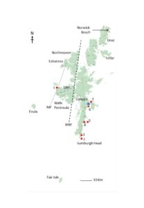
Figure 1. Shetland is a group of more than 100 islands, which are all included in the UNESCO Global Geopark. The largest island is Mainland, with the main town of Lerwick (blue) on its east coast, surrounded by numerous smaller islands including Foula 32 km to the west (noted for the second highest cliffs in the UK) and Fair Isle 38 km to the south. Also shown is the Walls Boundary Fault (WBF), Melby Fault (MF) and Sulma Water Fault (SWF), and main fish beds (red): 1, Melby; 2, Sumburgh Head; 3, Exnaboe; 4, Sandwick; 5, Mousa; 6, Ness of Sound; 7, Bressay.
The oldest Devonian sediments were deposited in the Walls Basin in western Shetland between the Melby and Walls Boundary faults (Fig. 1). They form the Walls Sandstone Formation, divided into two units by the Sulma Water Fault (Mykura et al. 1976; Mykura and Phemister 1976). Below the fault is the Sandness Formation (Lower Devonian; British Geological Survey 2020) comprising a lower part of sandstones, conglomerates and breccias deposited in a fluvial setting, followed by the Clousta Volcanic Member (Mykura and Phemister 1976). Above the fault is the Walls Formation (Middle Devonian; British Geological Survey 2020), a unit of highly folded, dark-gray, fine-grained sandstone often interbedded with siltstone, shale and limestone. The depositional setting is thought to have been freshwater (lacustrine) but is still debated; the Formation has been interpreted as representing a relatively deeper body of inland water laid down in a way comparable to flysch and turbidite sediments deposited in or on the slopes of marine basins (Mykura and Phemister 1976). Fossils occur in both divisions.
The Middle Devonian Melby Sandstone Formation (Eifelian-Givetian) was deposited in the Melby Basin at the western tip of the Walls Peninsula, west of the Melby Fault (Fig. 1). The Formation is considered fluvial and comprises red and buff cross-bedded sandstones, pebbly sandstones, siltstones and mudstones with two pale-grey siltstone and shale layers known as the Melby Fish Beds deposited in a shallow lake setting (Mykura and Phemister 1976; British Geological Survey 2020). The sediments exposed on Foula were also deposited in the Melby Basin. These comprise medium-grained sandstones with cross bedding and scattered pebbles of quartz and granite, with limited occurrences of siltstones and mudstones containing plant fossils, and shales, some red in color and/or with mud cracks indicating relatively shallow water (Mykura et al. 1976).
Devonian sediments east of the Walls Boundary Fault were deposited in the south-east Shetland Basin. Exposures are discontinuous from Sumburgh Head at the southern tip of Shetland to Rova Head a few kilometers north of Lerwick and across the islands of Mousa, Noss and Bressay (Mykura et al. 1976; Swartz 2009). The basin is described as elongate and oriented in a NNW-SSE direction with sediments divided into facies deposited in alluvial, fluvial, lacustrine and eolian settings (Finlay 1926; Mykura and Phemister 1976; Allen and Marshall 1981). Swartz (2009) proposed three specific lacustrine facies: 1, lake margin sediments with ripples and wave action, 2, transitional lake sediments with cross-beds, laminations and ripple marks containing plant fossils, and 3, deeper water sediments lacking wave and ripple structures noted for fish fossils. Remains of fish and plants have been found in beds of siltstone, mudstone and impure limestone, notably at Sumburgh Head, Exnaboe, Mousa, Sandwick, Ness of Sound and Bressay (Fig. 1-2). Fair Isle lying to the east of the Walls Boundary Fault is a further extension of the south-east Shetland Basin. Fine-grained sandstones with dolomitic sandstone and mudstone layers form the Lower Devonian Observatory Sandstone Formation, with alternating sandstones and siltstones of the Middle Devonian Bu Ness Sandstone Formation above (British Geological Survey 2020), both of which contain fragmentary fossils (Mykura et al. 1976).
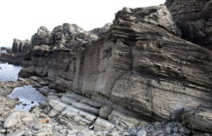
Figure 2. Outcrops of Devonian rocks at Exnaboe in south-east Shetland (copyright Billy Fox).
Paleontology
Fossils from the Devonian of Shetland comprise a fauna of fish, primitive plants and branchiopod (clam shrimp) crustaceans. The Lower Devonian Sandness Formation is the source of plant material assigned to Psilophyton sp. with fragments of an acanthodian and other sarcopterygian remains in the Middle Devonian Walls Formation; fragments of hostimellid plants are found in both divisions of the Walls Sandstone Formation (Watson 1934; Mykura and Phemister 1976). The Middle Devonian Melby Fish Beds are described as the best source of fish on Shetland with examples of Coccosteus cuspidatus Miller ex Agassiz, Dipterus valenciennesi Sedgwick and Murchison, Glyptolepis cf. leptopterus Agassiz, Gyroptychius agassizi (Traill), Cheiracanthus sp., Mesacanthus sp., Pterichthyodes sp. and Homosteus milleri Traquair alongside plant remains (Mykura and Phemister 1976). Siltstones and mudstones on the island of Foula also contain plant fossils however, most are indeterminant and it is not possible to date these more precisely (Mykura et al. 1976).
In the southeast of Shetland, the Middle Devonian Sumburgh Head, Exnaboe, Sandwick and Mousa fish beds (Fig. 1) have yielded examples of the fish Coccosteus sp. nov. (most likely Watsonosteus cf. fletti, pers. comm. Michael Newman; Miles and Westoll 1963), Dipterus valenciennesi, Glyptolepis?, Microbrachius dicki Traquair, Stegotrachelus finlayi Woodward and White (Fig. 3) and Tristichopterus cf. alatus Egerton, with the branchiopod ‘Estheria’ sp. (probably related to Ipsilonia orkneyensis, Chen and Morris 1991). The Ness of Sound and Bressay fish beds yield Asterolepis sp., Holonema ornatum Traquair, and Glyptolepis cf. paucidens (Agassiz), and plant remains including the recognizable ‘Corduroy Plant’ (Fig.3; Peach 1877; Allen and Marshall 1981). Slight differences in age and environment are indicated across the south-east Shetland Basin, for example, Asterolepis sp.and Glyptolepis in the Ness of Sound and Bressay fish beds suggest the upper layers might be Upper Devonian (Murchison 1853; Mykura et al. 1976). The placoderm Asterolepis thule was described by Watson in 1932 and has been found only at Sumburgh Head, suggesting the most southerly fish bed is the oldest of those occurring in the south-east Shetland Basin (Newman and Den Blaauwen 2018). The Exnaboe Fish Beds are noted as the thickest, due to deposition in comparably deeper freshwater, and is the type locality for the stem actinopterygian Stegotrachelus finlayi.
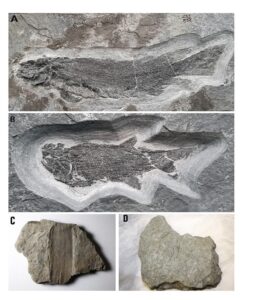
Figure 3. Devonian fossils from Shetland: a, fish Dipterus valenciennesi measuring 24cm from Exnaboe (image Roger Jones, Wimbledon); b, fish Stegotrachelus finlayi measuring 11cm from Exnaboe, the type locality for the species (image Roger Jones, Wimbledon); c, fragment of the distinct ‘Corduroy plant’, stem width approximately 10 cm (Shetland Amenity Trust); d, trace fossils from Sandness in specimen measuring approximately 20 cm across (Shetland Amenity Trust).
On Fair Isle, the Lower Devonian Observatory Group contains fossils of the plants Dawsonites roskillensis Chaloner, Hostimella sp. and Thursophyton milleri (Salter), cycloid fish scales and ‘Estheria’ (Chaloner 1972; Mykura et al. 1976). The Middle Devonian Bu Ness Sandstone Formation has yielded the plants Hostimella sp., cf. Prototaxites sp., Svalbardia scotica Chaloner and Zosterophyllum?, dipnoan scales, plates of a coccosteid placoderm and ‘Estheria’ (Chaloner 1972; Mykura et al. 1976).
Broader significance of the Shetland Fauna
The fossil faunas of Shetland are comparable in their diversity and preservation to those from Devonian exposures more widely across northeast Scotland (Mykura et al. 1976; Trewin 1976). Several fish species are cosmopolitan. For example, Tristichopterus and Microbrachius occur in the Sumburgh Head, Exnaboe, Sandwick and Mousa fish beds, the Eday Flags of Orkney and John O’ Groats Sandstone of Caithness suggesting a similar age, noted using miospores as Givetian (Allen and Marshall 1981). The Melby Fish Beds are correlated to the Sandwick Fish Beds, the layer separating the Lower and Upper Stromness Flags of Orkney, and the Achanarras/Niandt Limestone of Caithness, separating the Lower and Upper Caithness Flagstone Groups (Trewin 1976). The fish beds of Orkney and Caithness were deposited during an interval of relatively higher water level in Lake Orcadie (Westoll 1937; Trewin 1976) with water levels in lakes present elsewhere, for example, in the Melby Basin, also perhaps higher at the same time.
The Shetland fauna also includes endemic species that indicate isolation, certainly from Lake Orcadie to the south-east (Allen and Marshall 1981; Newman and Den Blaauwen 2018). For example, the placoderm Holonema and the actinopterygian Stegotrachelus are found only in the south-east Shetland Basin, with the lungfish Dipterus valenciennesi a relic of older faunas replaced by Pentlandia macroptera in the Eday Flags and John O’ Groats Sandstone (Newman and Den Blaauwen 2018). The inclusion of Stegotrachelus in numerous cladistic studies on the origins of bony fish further demonstrates the evolutionary significance of this taxon. The Corduroy Plant known from Lerwick and Bressay also occurs in the Sandwick area and on Fair Isle suggesting a similar age across the South-east Shetland Basin, but is absent from Orkney and Caithness (Allen and Marshall 1981). Abundant but stratigraphically restricted miospore assemblages show greater affinities to those of Russia and Europe (Baltica) than to Orkney and Caithness (Allen and Marshall 1981). Species of Asterolepis are widespread and distinct enough in the north-east of Scotland and Baltica for use biostratigraphically (Newman and Den Blaauwen 2018, fig. 9) with the potential for correlation to Greenland (Westoll 1937).
Designation as a UNESCO Global Geopark
Under the management of the Shetland Amenity Trust, created in 1983, Shetland was designated as a European Geopark in 2009 and a Global Geopark in 2010 (Lemon et al. 2013); the latter encompasses the entire island group (Fig. 1). Developments toward Shetland as a UNESCO Global Geopark began in 2006. Over £250,000 of funding has since been secured for interpretive and educational projects, promotional activities and improving infrastructure across the islands to support the geological aspect of the tourism industry.
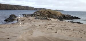
Figure 4. Contact between continental crust (left of dashed line) and oceanic crust emplaced to form the Shetland Ophiolite (right) at Norwick Beach on Unst. View looking approximately to the east.
The specific geological features that make Shetland an important area for Earth heritage and justify its Global Geopark status are:
1. The Shetland Ophiolite (Highton and Wignall 2020). Ophiolites have been identified around the world (Troodos Ophiolite within the Troodos Geopark, Cyprus (Gass 1980; Bukała et al. 2016), and Leka Ophiolite within the Trollfjell Geopark, Norway (Flinn and Oglethorpe 2005)), although the Shetland Ophiolite is described as ‘the most compact, best exposed, complete and accessible [ophiolite] in the world’ (Professor Derek Flinn, Liverpool University; Mykura et al. 1976; Flinn 2014). Rocks on the islands of Unst and Fetlar show a Lower and Upper Nappe, separated from the Basement by the Lower Imbricate Zone, a thrust, and from each other by the Middle Imbricate Zone, a second thrust (Flinn 2014; Highton and Wignall 2020). It is possible to see the contact between the continental and oceanic crust at Norwick Beach on Unst (Fig. 1 and 4), and evidence of metamorphism during emplacement is present as the elongated clasts of the Devonian Funzie Conglomerate, among other features (Flinn 1956; Highton and Wignall 2020).
2. The Shetland Volcano, active 395 Ma, provides an excellent view inside a volcano (Fig. 5). Coastal erosion has exposed a cross-section of the cone structure, revealing layers of Devonian pillow lavas and flows (basalt, andesite, rhyolite), agglomerates and pyroclastic (lapilli tuff, ash, ignimbrite) material from multiple eruption events (Flinn et al. 1968). The remains of a volcanic vent and solidified magma in a chamber that once fed volcanoes at the surface are present nearby.
3. The Walls Boundary Fault runs north–south across Shetland (Fig. 1) and is considered the northern extension of the Great Glen Fault beyond the Scottish Highlands, one of Europe’s major tectonic features (Flinn 1961). It was active primarily in the Devonian, achieving 30–80km of displacement, with the similarly trending Melby and Nesting faults dividing Shetland into a series of basins that became the main depositional centers (Mykura et al. 1976; Allen and Marshall 1981).
4. Devonian sediments contain a fauna of fish, plants and invertebrates representing early terrestrial and lacustrine settings. The fish and plants have been used to correlate sediments across Shetland and to the northeast of Scotland and Baltica beyond, among other uses (Fig.4; Watson 1932, fig. 4; Trewin 1976; Swartz 2009; Newman and Den Blaauwen 2018).
5. Sediments accumulated in a failed rift 300 million years ago in the North Sea are an important source of oil today. Later rifting lead to the opening of the North Atlantic Ocean, permanently separating Shetland from the North American Continent.
6. The most recent mark on Shetland was left by glaciation in the last few thousand years (Peach and Horne 1879). Features include rounded hills, roches moutonnées and hollows now forming inland lochs (Mykura et al. 1976).
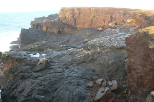
Figure 5. The Breigio lava domes, one of the many igneous features of the Eshaness Volcano, revealed in coastal exposures on the Eshaness Peninsula, western Shetland.
Public Engagement
Exhibits and events
Displays in the Shetland Museum and Archives in Lerwick are an excellent starting point to learn about the geological and cultural history of the islands, with the Heritage centers at Unst and Scalloway, Fetlar Interpretive Centre, Tangwick Haa Museum on Eshaness, the Old Haa at Burravoe and Braewick Cafe at Eshaness presenting rocks and minerals found in the respective areas. Shetland Amenity Trust organizes related events throughout the year, notably, the annual Shetland Nature Festival in partnership with European Geoparks Week, which includes geology-specific events and information on geology as part of the cultural and natural heritage, such as crofting, archaeology, flora and fauna.
Geotourism and Geosites
Geodiversity is promoted at Shetland’s entry points (Northlink Ferry Terminal in Lerwick and Sumburgh Airport) with extensive information resources for visitors (geology, archeology, wildlife, many focusing on a single island) available prior to and on arrival on the islands. The extraordinary geological heritage on Shetland has been highlighted for visitors to see, up close, at more than 100 geosites across the islands. Geosites example whole or parts of specific geological features and aspects relating to the geology, such as industrial workings, described in interpretation panels at key locations. Visitors can independently explore the geology of Shetland with regional leaflets providing geosite and themed information, such as ‘Shetland Geology’, an overview of the Geopark, ‘Shetland Rocks!’ and ‘Shetland Museums and Heritage Centres’, created by the Shetland Amenity Trust. Two multiple-site, self-guided trails have been created by Shetland Geopark and Scottish Natural Heritage on the ‘Shetland Ophiolite’ and ‘Shetland Volcano’. Geological walls have been constructed at Unst (Fig. 6), Fetlar and Northmaven with numerous interpretation points across the islands; these can also be investigated using the extensive website (https://www.shetlandamenity.org/geopark-shetland). The geosites and geotrails are linked to a wider network of paths, notably the Shetland Core Paths, a framework of natural and constructed routes designated by Shetland Islands Council to enable public access to all areas of Shetland wherever possible.
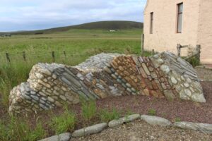
Figure 6. The geological wall outside the Unst Heritage Centre, Haroldswick, constructed using samples of the specific rocks to show the lithologies and their relative positions (Photo SRB). To the left (west) are continental rocks and to the right (east), layers of obducted oceanic crust. The steep dip of the layers is the result of the collision that closed the Iapetus Ocean. A small, rectangular silver sign shows the position of the ‘Moho’ (Mohorovicic Discontinuity), the contact between the crust and mantle, normally at a depth of 35 km.
Education
The Shetland Environmental Education Partnership (ShEEP) is a collaboration between Scottish Natural Heritage, Shetland Islands Council and several sections of the Shetland Amenity Trust (Shetland Geopark, Shetland Museum and Archives, Woodlands, Ranger Service) among others. It aims to raise awareness and understanding of Shetland and the wider environment in partnership with education providers through talks, lectures, workshops and guided walks, and to provide practical support for schools in the delivery of the Scottish Curriculum for Excellence.
Guided Geological Tours
The extensive geological history of Shetland has created dramatic coastal and inland scenery and influenced the extensive cultural heritage and wildlife of the islands, all of which are within reach of Lerwick. Organized excursions to see the geosites across Shetland have existed in the past but are not running currently. There is potential to offer these again, perhaps focusing on specific regions or features (faults, volcanoes, or fossils). Outdoor learning (education) opportunities are available and could incorporate geology. Any engagement of this type will however require the presence of staff and/or volunteers to manage bookings and conduct tours, with tour guides needing extensive knowledge of the geology.
Conserving Shetland’s Geosites
Various methods have been used to promote Shetland’s geology (described above), leaving the monitoring and conservation of the geosites into the future as an obvious area of focus, especially given the potential for an increase in visitor numbers and promotion as a year-round tourist destination (Shetland Tourism Strategy 2018-2023). The leaflets and trail guides already highlight the ‘Collecting Code of Conduct’ to educate those reaching the geosites. Key management objectives have been the development of the geosite register, establishing site boundaries where necessary, and the production of a photo archive for reference and to inform local planning within the Shetland Geopark and collaborative organizations.
A major development for Shetland geology and the Geopark has been the implementation of the Scottish Geodiversity Charter in 2012 (Lemon et al. 2013). The Charter was developed by the Scottish Geodiversity Forum, set up in 2011 to represent the voluntary geoconservation sector, in collaboration with Scottish Natural Heritage, the British Geological Survey and Scottish Government to promote the wider value of Scotland’s geological heritage. The four main aims of the Charter are: to raise awareness of the importance of geodiversity, integrate geodiversity and sustainability into relevant policies, conserve and enhance geodiversity, and improve understanding of the wider role of geodiversity.
Shetland has other relevant designations, most notably as a Geological Conservation Review (GCR) ‘block’ encompassing the ‘Caledonian Structures of Shetland’ (Highton and Wignall 2020). The GCR was launched in 1977 by the Nature Conservancy Council to assess and document important geological heritage. Blocks are areas with sites representing portions of the geological column, recognized or being considered as Sites of Special Scientific Interest (SSSIs). To date, the areas of Melby, Sumburgh Head and the Cletts (Exnaboe), including fossiliferous sites, are among those recognized on Shetland as SSSIs. GCRs are managed by the Joint Nature Conservation Committee, National Resources Wales, Natural England and NatureScot (the operating name of Scottish National Heritage) for the purposes of conservation (Highton and Wignall 2020).
Parts of Shetland have been included in additional conservation designations, notably the European Union Special Areas of Conservation (specifically natural habitats and wild fauna and flora) and Special Protection Areas (conservation of wild (rare and vulnerable) birds) directives, the NatureScot National Scenic Areas, and Marine Protected Areas (conservation of seascapes, marine habitats and species), each with their own conservation objectives.
Conclusions
The rocks of Shetland document continental movement, major plate tectonic events and climatic changes through almost three billion years of geological time. In addition, the Devonian rocks contain a diversity of fossils, which have been used in a range of paleontological studies. This extraordinary geological heritage is already apparent at several information points and through various resources, encouraging visitors to explore the islands while visiting and at a distance through a detailed website. Overall, the work of the Geopark has been very successful with many organizations on the islands involved, notably through the Shetland Geopark Partnerships launched in 2019 to encourage work with local businesses, along with several organizations from beyond.
As for the future, the various initiatives and methods of promotion must be maintained, with sufficient new and related activities to sustain and further raise interest. While people will obviously be encouraged to visit the islands, the location of Shetland is perhaps a main factor to consider in planning and implementation. For example, access will be determined by available seats on flights and overnight ferry and the facilities present to accommodate visitors, which might be a method of preventing the infrastructure and hospitality sector from being overwhelmed. Geotourism on Shetland must also remain balanced with other aspects of island life, such as limiting access to geosites at certain times of the year, because of their proximity to nesting birds.
Even now, a positive point for anyone making the journey to Shetland is the accessibility of sites across the islands, with immediate rewards of wild and rugged scenery, abundant wildlife, cultural history and rich geology.
Acknowledgments
Many thanks go to Dr Carol Christiansen (Shetland Amenity Trust) for time and assistance gathering information, maps and photographs, and to Billy Fox and Roger Jones for permission to use images. The author thanks Michael Newman and Malcolm Hart for their reviews and constructive comments.
References
Allen PA & Marshall JEA (1981). Depositional environments and palynology of the Devonian south-east Shetland basin. Scottish Journal of Geology. 17: 257–273.
British Geological Survey (2020). The BGS Lexicon of Named Rock Units [online]. Keyworth, Nottingham. Available from https://www.bgs.ac.uk/technologies/the-bgs-lexicon-of-named-rock-units/.
Bukała M, Zboińska K & Szadkowski M (2016). Troodos ophiolite mantle section exposed along Atalante Geo-Trail, Troodos Geopark, Cyprus. Geoscience Records. 3(1): 1–6.
Chaloner WG (1972). Devonian plants from Fair isle, Scotland. Review of Palaeobotany and Palynology. 14: 49–61.
Chen P-J & Morris S (1991). Ipsilonia – A Devonian conchostracan from Orkney, Scotland. Acta Palaeontologica Sinica. 30: 243–245.
Finlay TM (1926). The Old Red Sandstone of Shetland. Part 1. South-eastern area. Earth and Environmental Science Transactions of The Royal Society of Edinburgh. 54: 553–572.
Flinn D (1956). On the deformation of the Funzie conglomerate, Fetlar, Shetland. Journal of Geology. 64: 480–505.
Flinn D (1961). Continuation of the Great Glen fault beyond the Moray Firth. Nature London. 191: 589–591.
Flinn D (2014). Geology of Unst and Fetlar in Shetland. British Geological Survey. Edinburgh: HMSO for Institute of Geological Sciences.
Flinn D, Miller JA, Evans AL, Pringle IR (1968). On the age of the sediments and contemporaneous volcanic rocks of western Shetland. Scottish Journal of Geology, 4: 10–19.
Flinn D & Oglethorpe RJ (2005). A history of the Shetland Ophiolite Complex. Scottish Journal of Geology. 41: 141–148.
Gass IG (1980). The Troodos massif: Its role in the unravelling of the ophiolite problem and its significance in the understanding of constructive plate margin processes. In A. Panayiotou (Ed.), Ophiolites, Cyprus Geological Survey (pp. 23–35).
Hibbert S (1819-1820). Sketch of the distribution of rocks in Shetland. Edinburgh Philosophical Journal. 1: 296–314; 2: 67–79, 224–242.
Hibbert S (1822). Description of the Shetland Isles. Edinburgh.
Highton AJ and Wignall RML (2020) The Caledonian Structures of Shetland - Funzie and Norwick. Geological Conservation Review sites. Proceedings of the Geologists’ Association 132: 1–15.
Hooker JD (1853). Note on the fossil plants from the Shetlands. Quarterly Journal of the Geological Society of London. 9: 49–50.
Jameson R (1798). An Outline of the Mineralogy of the Shetland Islands: And of the Island of Arran. Edinburgh.
Lemon K, Barron HF& Gordon JE (2013). Scotland’s Geodiversity Charter: a step forward for Scottish Geoparks. 12th European Geoparks Conference. In Aloia, A, Calcatera, D, Cuomo, A, De Vita, A and Guida, D (Eds.), Proceedings of the 12th European Geoparks Conference (pp. 150–153). National Park of Cilento, Vallo di Alburni Geopark.
Miles RS & Westoll TS (1963). Two new genera of coccosteid Arthrodira from the Middle Old Red Sandstone of Scotland, and their stratigraphical distribution. Transactions of the Royal Society of Edinburgh. 65: 179–208.
Murchison RI (1853). Note on the Age and Relative Position of the Sandstone containing Fossil Plants at Lerwick in the Shetland Isles. Quarterly Journal of the Geological Society of London. 9: 50–51.
Mykura W, Flinn D & May F (1976). British regional geology: Orkney and Shetland (p. 149). Edinburgh: HMSO for Institute of Geological Sciences.
Mykura W and Phemister J (1976). Geology of Western Shetland. Edinburgh: HMSO for Institute of Geological Sciences.
Newman MJ and Den Blaauwen JL (2018). A redescription of the endemic antiarch placoderm Asterolepis thule from the Middle Devonian (Givetian) of Shetland and its biostratigraphical horizon. Scottish Journal of Geology. 54: 69–75.
Peach BN (1877). Notes on the fossil plants found in the Old Red Sandstone of Shetland, Orkney, Caithness, Sutherland and Forfarshire. Edinburgh Geological Society. 3: 148–152.
Peach BN & Horne J (1879). The glaciation of the Shetland Isles. Quarterly Journal of the Geological Society. 35: 778–811.
Shetland Amenity Trust website: https://www.shetlandamenity.org/geopark-shetland)
Shetland Tourism Strategy 2018-2023 (2018, October 30). Shetland Tourism Association. https://www.shetlandtourismassociation.org/strategy. Retrieved August 24, 2020.
Swartz BA (2009). Devonian actinopterygian phylogeny and evolution based on a redescription of Stegotrachelus finlayi. Zoological Journal of the Linnean Society. 156: 750-784.
Traquair RH (1908). On fossil fish remains from the Old Red Sandstone of Shetland. Transactions of the Royal Society of Edinburgh. 46: 321–329.
Trewin NH (1976). Correlation of the Achanarras and Sandwick Fish Beds, Middle Old Red Sandstone, Scotland. Scottish Journal of Geology. 12: 205–208.
Watson DMS (1932). On three new species of fish from the Old Red Sandstone of Orkney and Shetland. Memoirs of the Geological Survey of Great Britain, Summary of Progress for 1931. 2: 157–165.
Watson DMS (1934). Report of fossil fish from Sandness, Shetland. Memoirs of the Geological Survey of Great Britain, Summary of Progress for 1933. 1: 74–76.
Westoll TS (1937). The Old Red Sandstone fishes of the north of Scotland, particularly of Orkney and Shetland. Proceedings of the Geologists' Association. 48: 13–45.