Introduction
The Black Country UNESCO Global Geopark (Prosser 2020; Worton & Prosser 2021) https://blackcountrygeopark.dudley.gov.uk/bcg/) lies immediately to the west of the city of Birmingham in central England, UK (Fig. 1). It is 356 km2 with a population of 1.1 million people and is underlain by one of the earliest and most important coalfields and industrial areas in the UK. Jukes (1859) noted that the South Staffordshire (Black Country) coalfield is unique amongst British Coalfields because of its concentration of minerals in its condensed sequences, whilst Elihu Burritt, the American Consul in Birmingham, wrote "The Black Country …. cannot be matched for vast and varied production, by any other space of equal radius on the surface of the globe" (Burritt 1868). The presence of raw minerals (Carboniferous coal, iron and clay; Silurian limestone) near the surface (quarried and then mined) led to the early establishment of this intensive industrial area. First records of coal mining in the area date from 1273 (Rowlands 1987) and the demand for minerals continued to grow to supply local industry such that by 1665 there were already thousands of iron works scattered across the landscape around Castle Hill in Dudley (Dudley 1665). This intensity of mining and industry destroyed the green fields and woods and blackened the landscape, whilst furnaces were in flame day and night. The term ‘Black Country’ reflects this landscape, described in ‘Walks in the Black Country and its green border-land’ (Burritt 1868), as ‘a country black by day and red by night’. Other industries also became established, perhaps most notably the glass industry using coal to fire furnaces and Carboniferous fireclay to line furnaces enabling the high temperatures of glassmaking to be reached. Today, glass furnaces can still be visited at the Red House Glass Cone (for more information on Black Country history and culture see: http://blackcountryhistory.org).
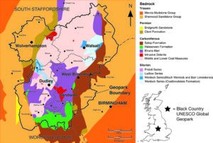
Figure 1. Black Country UNESCO Global Geopark, showing its underlying geology and location.
It is this industrial activity, with its associated excavation and mineral exploitation, including the construction of hundreds of miles of canals, which exposed more rock layers and opened the ground to the burgeoning science of geology. For example, Murchison visited the area during the 1830s, at a time of the most intensive mining and industrialization of the Black Country and was able to access fresh exposures and consult widely with the mining community to gain a systematic understanding of the local geology. His magnum opus, ‘The Silurian System’ (Murchison 1839), established a framework for the subdivision of Silurian stratigraphy and draws heavily on material collected from the mined limestone caverns of Dudley. A detailed understanding of the area’s complex Late Carboniferous geology was also being established at this time, with plant collections from Carboniferous coal mines, spoil heaps and iron workings permitting correlation within and between coalfields of the 1850s (Jukes 1859; Kidston 1914; Kidston 1923-25). A desire to conserve this resource through protecting what remains of these industrial sites and the collections they have produced led to the Black Country playing a leading role and serving as a testing ground for geoconservation (Box & Cutler 1988; Prosser & Larwood 2008; Worton 2008). This combination of pioneering work in both geoscience and geoconservation was important in gaining UNESCO Global Geopark status.
Geological setting
A substantial volume of geological literature, particularly a suite of geological memoirs produced by the British Geological Survey (BGS), trace the understanding of the geology of the Black Country and its immediate surroundings over time. The earliest detailed collation of information was the survey by Jukes (1859), with the most significant recent revisions being Powell et al. (1992), who provided a geological context for planning and development, and Waters et al. (2013).
The central section of the Black Country (Fig. 1) comprises folded and faulted Silurian and Carboniferous sedimentary rocks with rich and beautifully preserved fossil fauna and flora. This inner core is flanked by downfaulted younger terrestrial Permian and Triassic red beds to the east and west and overlain by a thin cover of Quaternary deposits (cut by deeper glacial channels) across the northern part of the Black Country. The whole area is underlain at depth by a rigid crustal block (known as the Midlands Microcraton) which prevented intense deformation of these strata during two orogenic episodes and restricted basin subsidence. The resulting condensed sequences in effect ‘concentrated’ the paleontological content of the strata and promoted conditions in which exceptional preservation could occur.
The abundance and proximity of economically important mineral resources established the Black Country as the earliest industrialized conurbation, and access to well exposed geological sequences played a significant role in the development and application of geoscience. The world’s oldest ‘true’ geological map with a scale, geographic features and named mineral horizons was created here in 1665 (Dudley 1665), the oldest geophysical investigations (density logging) took place here in the early 1700s (Bellers & Hauksbee 1710) and one of the world’s earliest recording seismographs was manufactured here (in West Bromwich) in 1913 (Musson 2013). Connecting canals, mining invention and innovation, and the consequent exposure of surface to deep strata led to paleontological discoveries. In turn, this led to a reputation as a source of spectacular fossils and a major area for geological research during the 1830s, leading to the naming of the Silurian Period of geological time (Murchison 1839).
Silurian geology and paleontology
The oldest exposed strata of the Black Country are folded inliers of Silurian marine carbonate dominated sedimentary rocks forming the prominent Castle, Wren’s Nest and Sedgley Hills in Dudley and the landscape around Walsall (Butler 1939). The Silurian exposures contain complete uninterrupted Much Wenlock Limestone Formation and Lower Ludlow successions deposited in a shallow marine shelf sea (Aldridge et al. 2000; Ray & Thomas 2007). Lithological, sedimentological, geochemical and paleontological evidence indicates a mid-inner platform position on the eastern margin of a subduction zone with distal island arc volcanism (the closing Iapetus Ocean) (Ratcliffe & Thomas 1999; Ray et al. 2011). The depositional setting is interpreted as a back-reef lagoon with the development of patch reefs and shelly shoals (Ray et al. 2010). Of particular relevance to the exceptional preservation of lagerstätten in these sequences are numerous bentonite clays representing eruptive phases of the island arc volcanoes. The bentonites rapidly buried and preserved in situ seafloor community assemblages in life position including microfaunas that are currently being studied (for example, Jarochowska et al. 2018) and have also yielded isotope dated zircons (Cramer et al. 2012). Paleontological evidence indicates a tropical climate, shallow water (dominantly within the photic zone environment, with water depths varying between slightly above fair weather wave-base and slightly below storm wave-base) during the main Wenlock limestone formation with preceding and succeeding times of prevailing deeper water conditions.
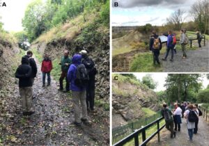
Figure 2. Wren’s Nest National Nature Reserve and Geosite, geotrail locations. A) trench excavated in 1977 providing a dip section through the Nodular Member of the Much Wenlock Limestone Formation on the eastern side of the Wren’s Nest Hill. B) Landscape specialists at the quarry viewpoint: the surrounding Wren’s Nest housing estate (on Coal Measures) is seen in the distance, in the middle ground is a prominent reef bioherm of the Nodular Member and the remnants of the elongate quarry in the Lower Quarried Limestone Member. C) Geoconservation training at the viewing platform for the Seven Sisters caverns. The fence encloses unstable ground (due to mining subsidence) where remaining pillars of the Seven Sisters caverns are visible. Here limestone was mined following the steeply dipping beds into the hillside, the caverns have been temporarily infilled with aggregate to prevent collapse.
The Much Wenlock Limestone Formation of the Black Country is classically exposed in the Wren’s Nest National Nature Reserve (Fig. 2) in the heart of Dudley (Cutler et al. 1990) where more than 600 marine invertebrate macrofossil species belonging to 27 different taxa are found (Aldridge 2000; Reid & Gryckiewicz 1995). A selection of these are illustrated in Figure 3. Over 65% of the Wenlock species illustrated in ‘The Silurian System’ (Murchison 1839) are from the Geopark. Such was the fame and enthusiasm for these fossils that the trilobite Calymene blumenbachii (Fig. 3A) became the mascot of the limestone miners and was adopted into Dudley’s coat of arms (Mikulic & Kluessendorf 2007). Among scientists of the day, it earned the title the Dudley Fossil (Parkinson 1804-1811) and is now amiably referred to by local people as the Dudley Bug.
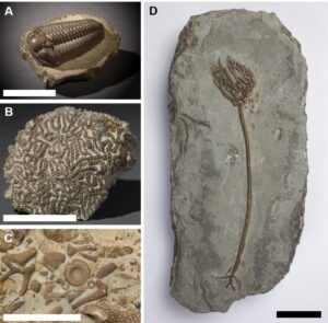
Figure 3. Silurian fossils from the Much Wenlock Limestone Formation of the Wren’s Nest NNR and Geosite. A) Calymene blumenbachii (Brongniart 1822), the ‘Dudley Bug’. B) Halysites catenularius (Linneaus 1822). C) Much Wenlock Limestone death assemblage. D) Gissocrinus goniodactylus (Phillips 1839). Scale bar = 5cm.
Carboniferous Geology and Paleontology
Unconformably flanking the Silurian inliers, Upper Carboniferous strata occupy the central area of the Black Country. Belonging to the Pennsylvanian Series, Pennine Lower, Middle and Upper Coal Measures (Westphalian A–D Epochs) sediments accumulated in a low lying, flat landscape covered in forests with numerous rivers, mudflats, and lakes at, or slightly north of, the equator in tropical climates. This gently subsiding environment was dominated by rhythmically repeating mudstones, siltstones, and sandstones with abundant economic minerals: fireclays, clays, ironstones, and the coals of the South Staffordshire Coalfield (Beasley 1987; Cleal & Thomas 1996).
Saltwells National Nature Reserve (Fig. 4), in Dudley, encompasses the characteristic strata of the Upper Carboniferous (Jukes 1859; Whitehead & Eastwood 1927; Cleal & Thomas 1996): cross-bedded river sandstone channels, siltstones, clays (a source of clay for Royal Doulton sanitaryware), and coal seams, including the still exposed ‘Heathen’ (Fig. 4D) and formerly the Thick Coal – a 12 m seam and the most productive of the Industrial Revolution. Carboniferous strata here are unconformable on Upper Silurian mudstones (Fig 4B) that have a diverse Ludlow marine fauna including fossils of early fish (Aldridge et al. 2000).
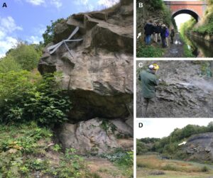
Figure 4. Saltwells National Nature Reserve and Geosite. A) Doulton’s Claypit, galvanized steel sculptural interpretation of the Carboniferous dragonfly Meganeura (artist Luke Perry) resting on Coal Measures river channel sandstone. B) Brewin’s Canal Cutting examining Silurian – Carboniferous unconformity (arrow), the canal (connecting with regional and national canal networks) was used to transport coal and clay from Saltwells. C) Cleaning Silurian Ludlow beds with portable high pressure hose. D) General view of Doulton’s Claypit showing alternating sandstone, shale and clay. The Heathen coal seam (arrowed) is visible in the main face.
Occasionally, conditions in these Carboniferous swamps produced exceptional preservation of terrestrial fossils (Fig. 5). Near Wolverhampton, siderite nodules in the Coseley lagerstätte (Fig. 5B) preserve plant and insect faunas in spectacular detail (Braznell 2005). Particularly significant are its trigonotarbid spider-mites (Garwood et al. 2009), other insects, arthropod and plant fauna and flora which provide a very useful comparator to the Mazon Creek deposits of the USA (Pacyna & Zdebska 2012). These fossils, now in museum collections including Dudley Museum at the Archives and the Lapworth Museum (Birmingham), were subject to collaborative international research including the application of new investigative x-ray microtopography techniques (e.g., Garwood & Sutton 2010; Garwood et al. 2009).
The only evidence of Carboniferous extrusive igneous activity occurs in the Etruria Formation at Kingswinford in the Barrow Hill and Tansey Green Clay Pit, where 10 m of gray-green volcanic ash and ejecta occur (Stephenson et al. 2003). Here, hydrothermal stockworks of alteration and steam eruption injected veins have been dated to 307Ma. These deposits preserve in anatomical detail early conifers in life position (Galtier et al. 1992; Glover et al. 1993). This site is also known as the ‘Dudley Volcano’ and the local community’s tenants and resident’s association has adopted the volcano as its logo.
The Permo-Triassic and Quaternary
With the formation of Pangea, arid climates dominated the Permo-Triassic environments of the Black Country. Exposures include red breccias, conglomerates, and aeolian sandstones, whilst alluvial clays and sandstones were deposited by major river systems flowing northwards across the region. Northern and eastern parts of the Geopark exhibit Quaternary glacial tills, fluvial outwash and river deposits, periglacial solifluction and mass movement. Glacial advance and retreat over the last 400,000 years have influenced the evolution of modern river systems and shaped today’s landscape. For example, Norton Covert, in the extreme southwest of the Geopark, exposes Devensian outwash gravels overlying Permo-Triassic alluvial Wildmoor Sandstone Formation (Black Country Geological Society 2008).
The UNESCO Black Country Geopark
The Black Country became a UNESCO Global Geopark in July 2020 with 44 Geosites (https://blackcountrygeopark.dudley.gov.uk/sites-to-see/) identified at the time of joining. Geological exposures within the Geopark are dominantly the remnants of mining, quarrying and engineering endeavors. It is the geoheritage accessible at these Geosites, their exceptional paleontology and paleontological collections, and the links to local geology, its industrial exploitation and local communities that provides the narrative of the Black Country UNESCO Global Geopark.
Geoconservation: There is a long history of geoconservation within the Black Country and the practice of conserving, improving, interpreting, and providing access to geological features is embedded in the policy and practice of the partners in the Geopark (Worton 2008; Prosser & Larwood 2008). This is in part due to the scientific significance of the geological features but also the challenge of conserving them within a rapidly developing urban setting (Bennett et al. 1996). The process of urban renewal creates opportunities but also presents potential for loss and damage of geological features to new development. As in most urban areas, geosites are subjected to heavy recreational use and are sometimes the victim of vandalism and illegal waste tipping. Further, occasional cases of irresponsible fossil collecting, in a setting where it is not practical to restrict access to geological features, poses further challenges. These challenges have necessitated innovative and often successful attempts to engage and involve local communities in understanding and helping to conserve geosites, rather than attempting to exclude them from what are often publicly accessible green spaces (Worton 2008; Prosser & Larwood 2008; Worton & Gillard 2013).
Nationally and internationally important sites have been assessed and identified through the Great Britain-wide Geological Conservation Review (Ellis et al. 1996) and are here legally protected through designation as nine Sites of Special Scientific Interest (SSSIs). Two of these SSSIs, having exceptional scientific importance, and wide scope for day-to-day management, interpretation and public access, have also been declared as National Nature Reserves (https://www.gov.uk/government/collections/national-nature-reserves-in-england); the Wren’s Nest (Fig. 2) in 1956 (Prosser & Larwood 2008) and Saltwells (Fig. 4) in 2020 (Larwood 2020). They have permanent wardens managing the geological features, volunteer groups that assist them, and are extensively used by local community and schools as well as by geologists. Both are regularly used to demonstrate good practice in geological conservation (Fig. 2C), interpretation and community engagement (through training courses, conferences, field excursions, guided walks and peer reviewed papers). For example, the Wren’s Nest has been the subject of pioneering work managing geological features (Prosser & Larwood 2008) and engaging with the local community (Worton & Gillard 2013) in a populated urban area and in a place subject to active ground subsidence. This has included one of the first self-guided geological trails (Warwick et al. 1967), trialing approaches to the management of fossil collecting, the cutting of a new geological section to replace a long-standing section which became too dangerous to access because of ground subsidence, geologically themed drama performances to engage with local youths, extensive use of volunteers in building paths and keeping geological features free of vegetation and scree, the use of vandal-resistant signage and interpretation, production of a fossil themed beer, ‘Trilobitter’, to raise awareness of the local geology and paleontology, and the long-term use of fixed point monitoring of geological features with nearly 40 years of data (Larwood 2002; Prosser & Larwood 2008; Roworth & Larwood 2004).
During the 1970s and 1980s, in response to development pressure affecting many locally important sites, an audit of geological features, led by the Black Country Geological Society (BCGS), was carried out. This audit generated a list of Local Geological Sites (Defra 2006; Worton 2008) recognized within the Black Country planning framework, which must be considered when assessing any development proposals. Recognition of these sites in the local planning system has also reduced the chance of them being accidentally damaged by developers ignorant of their importance or location.
Whilst many threats to geosites in the Geopark are anthropogenic, others are more natural in origin. Unchecked growth of vegetation on some sites requires regular cutting back and community groups, sometimes coordinated by local wardening teams, have engaged in this work. The Black Country Geological Society, inaugurated in 1975, has geoconservation at its heart, and every year organizes work parties to clear and maintain rock faces in geosites.
In addition to site-based conservation, the Geopark Headquarters (Dudley Museum at the Archives, and Geosite) in Dudley (Worton 2019) includes nationally significant collections of local paleontological material, including Carboniferous plant and invertebrate fossils (Fig. 5) and most notably Silurian trilobites, crinoids and other marine invertebrates (Fig. 3), amassed over the last 160 years. This collection contains several type and figured specimens including the specimen of Eucalyptocrinus crassus figured in Murchison’s ‘Silurian System’ in 1839.
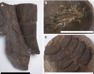
Figure 5. Carboniferous fossils, Coal Measures siderite nodules. A) Calamites suckowi (Brongniart 1822). B) Apthoroblattina sp. from Coseley Lagerstätten; C - Neuropteris gigantea (Sternberg 1825). Scale bar = 5cm.
National planning policy guidance in England (National Planning Policy Framework, 2019) requires local authorities to protect sites of geological value, ‘… in a manner commensurate with their statutory status or identified quality in the development plan’. In the Black Country, however, additional Supplementary Planning Documents have been produced. For example, the Dudley Borough Development Strategy Development Plan Document (adopted 2016) recognizes the importance of geological features within the context of sustainable development. At a strategic level the Black Country Core Strategy (https://blackcountryplan.dudley.gov.uk/t1/p2/) includes Policy ENV1 ‘Nature Conservation’, which recognizes the importance of geological features by stating that: ‘...Development within the Black Country will safeguard nature conservation, inside and outside its boundaries by ensuring that: Locally designated nature conservation sites (Sites of Local Importance for Nature Conservation), important habitats and geological features are protected from development proposals which could negatively impact upon them.....’. This long-term plan is currently being revised and will become ‘The Black Country Plan’ within the next few years. This is a significant step forward for the protection and profile of the Black Country’s geodiversity as it will contain specific policy for the UNESCO Global Geopark. Policies currently under consideration for inclusion specifically refer to geodiversity and the UNESCO Global Geopark and require developers to ‘seek to make a positive contribution to the protection and enhancement of the geodiversity’ and specifically to the nominated Geosites within it.
Education: The Black Country’s Geosites have traditionally been used for research, formal education and informal life-long learning welcoming researchers, students, and community groups enriching learning and providing inspirational places and experiences for all. Dudley was first visited by the Geologists’ Association in 1863 and it was noted then the ‘…several advantages and opportunities it [Dudley] afforded for study, to both the early and advanced student, of several of the great and characteristic phenomena recognised as causes, effects, and agencies by geological science’ (Geologists’ Association 1863). In 1898 the Geologists’ Association returned and record travelling on the underground canal between Castle Hill and the Wren’s Nest Hill in Dudley and being entertained by Professor Lapworth in the candlelit limestone caverns (Watts 1898). Most recently, in October 2018, the area jointly hosted the Geologists’ Association annual conference entitled ‘The Geology of Mordor’ drawing on the cultural connections with the industrial landscape and its reflections in popular literature such as JRR Tolkien's ‘Lord Of The Rings'.
There has been a particular focus in engaging young people in the Geopark’s geoheritage. For example, the ‘Waves’ project that linked schools, geosites and museums through fossil collections, the innovative ‘Wrosne’ theatre performance delivered by young people from the communities surrounding the Wren’s Nest NNR, and the museum’s GeoTeam, student volunteers (geology students from local schools and universities) (Worton & Gillard 2013). The GeoTeam supports the work of the Geopark helping document collections, undertake field logging and sampling and support a range of geoconservation activities, as well as growing the confidence, knowledge and experience of the GeoTeam volunteers. More recently the Geopark Headquarters (and many of the outdoor Geosites) have provided the resources for 45 Day Apprenticeships as well as support to professional learning and Continuing Professional Development (CPD).
Geotourism: In 1849, Sir Roderick Murchison attracted over 15,000 visitors to the limestone caverns of Dudley to tell stories of the Silurian System (Murchison 1839; The London Illustrated News 1849). At the heart of this is an unrivalled paleontological resource that has intrigued and engaged people from the earliest miners to families today who visit places such as the Wren’s Nest NNR (Mikulic & Kluessendorfk 2007). The strong connection between geodiversity, landscape, and the industrial and cultural heritage of the Geopark today, is a strong inspirational and enriching theme for local and regional communities who are proud of their connections to the history of the area. This is reflected widely in public artworks in many the communities. For example, trilobites feature in the borough of Dudley’s coat-of-arms and as art in brickwork forming part of a road-bridge, whilst mining heritage is reflected in large artworks such as The Colossus of Brownhills – a silver sculpture of a miner standing on a traffic island in the town of Brownhills near Walsall. Linking with planning, a new housing development in the Geopark has streets named ‘Fossil View’, ‘Calymene Mews’ and ‘Silurian Mews’.
The area’s prominence and importance in global geoscience and industrial history also attract international groups. The ‘Murchison Symposium’ visited the Black Country in 1989 on the 150th anniversary of the publication of ‘The Silurian System’, the ‘Trilobites and their Relatives’ Conference held field visits here in 2001, and the Silurian Sub-commission visited in 2011. Recent research projects have included international collaboration (Cramer et al. 2012; Jarochowska et al. 2018; Ray et al. 2020).
The development of geotourism in the Black Country is part of an ongoing process of overall tourism development in the region and the Geopark is written into strategic policies for the visitor economy. There is a strong and developing baseline infrastructure for tourism, with many existing visitor attractions and natural sites linked within the Geopark as a single landscape story. Some improvements in tourism infrastructure are planned for the Geopark, including the Midland Metro tramway system between the towns of Wednesbury and Brierley Hill which is currently under construction, adding 18 new stations and improving public transport within the geopark; five stations are on or immediately adjacent to named geosites, including the Geopark Headquarters. Interpretation on these stations and onboard this new transport network is currently being designed and will be in place when the region hosts the Commonwealth Games in August 2022.
There is huge potential for tourism growth and impacts on education, wellbeing, quality of environment, inward investment and overall economic performance of the Black Country. Tourism is promoted strongly (see Dudley Metropolitan Borough Council 2019) whilst visitor surveys (The research solution 2020) show a growing audience both in terms of UK and overseas audiences. Geotourism here provides the opportunity to tell geological stories that engage and inspire, attracting visitors (from local to global) and contributing to a new aspect of the tourism economy for the Black Country (Larwood & Worton 2018). This can only lead to a raised profile for the Geopark’s rich geoheritage.
The Future
The Black Country UNESCO Global Geopark was welcomed into the Global Geoparks Network in July 2020 as a different very urban territory with an extremely rich geological, paleontological and related cultural heritage in close contact with the local community (Fig. 6). In terms of its geology and paleontology, research on the microfauna of the Geopark’s Much Wenlock Limestone Formation is ongoing. This is providing a baseline understanding of the diversity and distribution of microfossils throughout these sequences and will be followed by publications on little-studied groups from these successions such as chitinozoans and scolecodonts. This research is being led by the Geopark and its volunteers in collaboration with the University of Portsmouth, University of Erlangen and the private sector company Neftex. The Geopark is also currently auditing the paleontology of the Coal Measures sequence from its historic museum collections in order to better understand its faunal and floral diversity. The Geopark’s existing geoconservation experience is being extended through the management program across the network of geosites working in collaboration with communities and agencies across the Geopark.
Figure 6. Showing the urban character of the Black Country UNESCO Global Geopark and the close proximity of Geosites to the local community. A) Tilted limestones bedding planes of the Wren’s Nest National Nature Reserve seen from Burton Road, Wren’s Nest Estate. B) Looking out from the Wren’s Nest National Nature Reserve across the Wren’s Nest Estate.
The Black Country UNESCO Global Geopark will enable reconnection of local communities to their shared geological heritage through increasing access to its geosites, a range of educational and interpretive initiatives, and through new connections with the global Geopark community. For example, existing resources for geosites are being reviewed and updated, a new visitor center at Saltwells National Nature Reserve is being fitted with new resources for learning, a 45-day apprenticeship scheme is being planned, familiarization trips for public sector workers and politicians are being scheduled, themed presentations at events and conferences will continue, virtual field excursions are being developed for those with accessibility challenges, bespoke on-site signage is being installed on key Geosites, updated field guides are being drafted and new online resources are being developed.
References
Aldridge RJ, Siveter DJ, Siveter DJ, Lane D, Palmer DC & Woodcock NH (2000). British Silurian Stratigraphy. Geological Conservation Review Series no. 19. Peterborough: Joint Nature Conservation Committee.
Bellers F & Hauksbee F (1710). XI. A description of the several strata of earth, stone, coal, &c. found in a coal-pit at the west end of Dudley in Staffordshire: By Mr. Fettiplace Bellers, F. R. S. To which is added, a table of the specific gravity of each stratum: Philosophical Transactions of the Royal Society of London Volume 27, 336; 541-544
Bennett MR, Doyle P, Larwood JG & Prosser CD (Eds.) (1996). Geology on your doorstep - The role of urban geology in Earth heritage conservation. The Geological Society, London,
Black Country Geological Society (2008). Norton Covert - A story of scorching deserts, icy wastes and woodland glades, leaflet published by Dudley Council and The Black Country Geological Society.
Box J & Cutler A (1988). Geological Conservation in the West Midlands. Earth Science Conservation, 25: 29-38.
Braznell LJ (2005). Exceptional Preservation in the Upper Carboniferous Coseley Lagerstätte. Bimingham University PhD thesis.
Burritt E (1868). Walks in the Black Country and its green border-land. Sampson Low, Son and Marston: London.
Butler AJ (1939). The stratigraphy of the Wenlock Limestone of Dudley, Quarterly Journal of the Geological Society of London. 95: 37-74.
Cleal CJ & Thomas BA (1996). British Upper Carboniferous Stratigraphy. Geological Conservation Review Series, No 11. London: Chapman & Hall.
Cramer BD, Condon DJ, Söderlund U, Marshall C, Worton GJ, Thomas AT& Jeppsson L (2012). U-Pb (zircon) age constraints on the timing and duration of Wenlock (Silurian) paleocommunity collapse and recovery during the “Big Crisis”. Geological Society of America Bulletin. 124: 1841-1857.
Cutler A, Oliver PG & Reid CGR (1990). Wren’s Nest Nature Reserve. Geological Handbook and Field Guide. Dudley MBC Leisure Services Department and Nature Conservancy Council.
Defra (2006). Local Sites - Guidance on their Identification, Selection and Management. Department for the Environment, Food and Rural Affairs.
Dudley Metropolitan Borough Council (2019). Dudley Borough visitor economy prospectus 2019/20, Dudley MBC.
Dudley D (1665). Metallum Martis. Privately published, printed T.H: London.
Ellis NV. (Ed), Bowen DQ, Campbell S, Knill JL, McKirdy AP, Prosser CD, Vincent MA, & Wilson RCL (1996). An Introduction to the Geological Conservation Review. GCR Series No 1, Joint Nature Conservation Committee, Peterborough.
Galtier J, Scott AC, Powell JH, Glover BW, & Waters CN (1992). Anatomically preserved conifer-like stems from the Upper Carboniferous, Proceedings of the Royal Society of London. 247: 211 -214.
Garwood R, Dunlop JA, & Sutton MD (2009). High-fidelity X-ray micro-tomography reconstruction of siderite-hosted Carboniferous arachnids. Biology Letters. 5: 841–844.
Garwood R & Sutton M (2010). X-ray microtomography of Carboniferous stem-Dictyoptera: new insights into early insects. Biology Letters. 6: 699–702.
Geologists’ Association (1863). Ordinary Meeting, Monday, July 6th, 1863. Proceedings of the Geologists’ Association 1: 334-344.
Glover BW, Powell HH & Waters CN (1993). Etruria Formation (Westphalian C) palaeoenvironments and volcanicity on the southern margins of the Pennine Basin, South Staffordshire, England. Journal of the Geological Society of London. 150: 737 – 750.
Jarochowska E, Ray DC, Röstel P, Worton G &Munnecke A (2018). Harnessing stratigraphic bias at the section scale: conodont diversity in the Homerian (Silurian) of the Midland Platform, England. Palaeontology. 61: 57–76.
Jukes JS (1859). The South Staffordshire Coalfield. Memoir of the Geological Survey of Great Britain, London.
Kidston R (1914). On the fossil flora of the Staffordshire Coal Fields. Part III. The fossil flora of the Westphalian series of the South Staffordshire Coal Field. Transactions of the Royal Society of Edinburgh. 50: 73–190.
Kidston R (1923–1925). Fossil plants of the Carboniferous rocks of Great Britain. Memoir. Geological Survey of Great Britain, Palaeontology. 2, Parts 1–4 (1923): 1–376, Part 5 (1924): 377–522, Part 6 (1925): 523–670.
Larwood JG (2002). The camera never lies. Earth Heritage. 19: 10-11.
Larwood JG (2020). Saltwells: England’s newest geological National Nature Reserve, Earth Heritage 54: 23-26.
Larwood JG, Worton G (2018). Geology for tourism professionals. In Dowling R and Newsome D (Eds), Handbook of Geotourism (pp. 26-47). Edward Elgar Publishing, Cheltenham: UK.
Mikulic DG & Kluessendorf J (2007). Legacy of the locust – Dudley and its famous trilobite Calymene blumembachii. In Mikulic DG, Landing E and Kluessendorf J (Eds.), Fabulous Fossils. 300 years of Worldwide Research on Trilobites. Albany: New York State Museum, 141-169.
Murchison RI (1839). The Silurian System. John Murray London.
Musson RMW (2013). A history of British Seismology, Bulletin of Earthquake Engineering, 11: 715-861.
National Planning Policy Framework (2019) (https://www.gov.uk/government/publications/national-planning-policy-framework--2
Pacyna G & Zdebska D (2012). Carboniferous plants preserved within sideritic nodules – a remarkable state of preservation providing a wealth of information Acta Palaeobotanica. 52: 247–269.
Parkinson J (1804-1811). Organic remains of a former world. An examination of the mineralized remains of the vegetables and animals of the antediluvian world; generally termed extraneous fossils. Third volume, London, 479 p.
Powell JH, Glover BW & Waters CN (1992). A geological background for planning and development in the ‘Black Country’. British Geological Survey, Technical Report WA/92/33 Onshore Geology Series.
Prosser CD (2020). A new UNESCO Global Geopark – the Black Country! Earth Heritage, 54: 23-26.
Prosser CD & Larwood JG (2008). Conservation at the cutting-edge: the history of geoconservation on the Wren’s Nest National Nature Reserve, Dudley, England [In: The history of Geoconservation (Burek CV, Prosser CD Eds.)]. Geological Society, London, Special Publications. 300: 217-235.
Ratcliffe KT & Thomas AT (1999). Carbonate depositional environments in the late Wenlock of England and Wales. Geological Magazine. 136: 189–204.
Ray DC & Thomas AT (2007). Carbonate depositional environments, sequence stratigraphy and exceptional skeletal preservation in the Much Wenlock Limestone Formation (Silurian) of Dudley, England. Palaeontology. 50: 197–222.
Ray DC, Brett CE, Thomas AT & Collings AVJ (2010). Late Wenlock sequence stratigraphy in central England. Geological Magazine. 147: 123–44.
Ray DC, Collings AV, Worton GJ & Jones G (2011). Upper Wenlock bentonites from Wren's Nest Hill, Dudley: comparisons with prominent bentonites along Wenlock Edge, Shropshire, England. Geological Magazine. 148: 670-681.
Ray DC, Jarochowska E, Rostel P, Worton G, Munnecke A, Wheeley JR & Boomer I (2020). High resolution correlation of the Homerian carbon isotope excursion (Silurian) across the Midland Platform, UK. Geological Magazine. 157: 603-620.
Reid CGR & Gryckiewicz M (1995). Castle Hill/Wren’s Nest Dudley. Faunal list for the Middle Silurian strata (Wenlock and Ludlow Series), published Dudley Museum and Art Gallery.
Rowlands MD (1987). A Regional History of England: the West Midlands from AD1000. published Longman:
Roworth P & Larwood JG (2004). Fixed-point photography. Conservation Land Management. 2: 15-17.
Stephenson D, Loughlin SC, Millward D, Waters CN & Williamson IT (2003). Carboniferous and Permian Igneous Rocks of Great Britain North of the Variscan Front, Geological Conservation Review Series, No. 27, Joint Nature Conservation Committee, Peterborough.
The London Illustrated News (1849). Meeting of the British Association for the Advancement of Geological Science, 391 (vol XV, p.201).
The research solution (2020). Economic impact of tourism – Dudley Borough 2019. The research solution, 21p.
Warwick GT, Strachan I & Stubbs AE (1967). The Wren’s Nest National Nature Reserve: A Guide to the Geology and Economic History of the Wren’s Nest National Nature Reserve including the Nature Trails. Nature Conservancy (pp. 1–31). London
Waters CN, Bridge DM, Humpage AJ, Barclay WJ & Smith NJP (2013). Geology of the Dudley District. A brief explanation of the Geological map 1:50,000 sheet 167 Dudley (England & Wales) British Geological Survey
Watts WW (1898). Long excursion to the Birmingham District. Thursday, July zsth, to Wednesday, August 3rd, 1898. Proceedings of the Geologists’ Association. 15: 417-428
Whitehead TH & Eastwood T (1927). The Geology of the Southern Part of the South Staffordshire Coalfield Dudley & Bridgnorth. Memoir of the Geological Survey of Great Britain.
Worton GJ (2008). A Historical perspective on local communities and geological conservation, [In: The history of Geoconservation (Burek CV, & Prosser CD Eds.)]. Geological Society, London, Special Publications. 300: 137 – 146.
Worton GJ (2019). Dudley Museum at the Archives – the evolution of geological heritage in Dudley. Earth Heritage, 51: 36-38.
Worton GJ & Gillard R (2013). Local Communities and young people – the future of geoconservation. Proceedings of the Geologists Association. 124: 681 – 690.
Worton G &Prosser C (2021) Introducing the Black Country UNESCO Global Geopark. European Geoparks Magazine. 18: 64