Introduction
The world’s paleontological heritage is one of the outstanding values of UNESCO Global Geoparks (UGGp) because of wide public interest (e.g., Martín-González et al. 2019). In many UGGp, singular fossils constitute a tourist appeal and attractive teaching resource for students and adult audiences, with the paleontological sites being the cornerstone of touristic and educative trails and other activities. However, fossils may be rare in many geoparks, as occurs at the Courel Mountains UGGp, one of 15 Spanish UGGp (Fig. 1A). This work aims to show the management of Palaeozoic fossils and their sites during the development of the Courel Mountains UGGp for research, geotourism, education and geoconservation purposes.
Location
The Courel Mountains UGGp (578 km2 in extent) was declared in 2019 based on its tectonic, geomorphological, mineralogical and stratigraphical relevance at national and international scales, highlighting the Global Geosite of Courel recumbent fold, declared also as a Natural Monument. The Geopark is formed by Neoproterozoic to Carboniferous slate, quartzite, marbled limestone, and gneiss (Fig. 1B, C) affected by the Variscan orogeny, forming recumbent and vertical folds with penetrative foliations, as well as faults (Martínez Catalán et al. 2016), some of which were also active during the Alpine orogeny. These processes limited the preservation of most of the fossil assemblages, which comprise mainly Cambrian archaeocyathids, Cambrian to Ordovician trilobites and trace fossils, Ordovician to Devonian crinoids and brachiopods, and Silurian graptolites, conodonts and cephalopods.
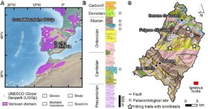

Figure 1. A) Location of the Courel Mountains UGGp. B) Stratigraphic section of the Geopark. C) Geological map of the Geopark after Villar Alonso et al. (2018), showing the Palaeozoic palaeontological sites.
Significance Level and Scientific Research
Palaeozoic fossil assemblages of the Courel Mountains UGGp have regional significance since the Geopark is located in the northwest part of the Iberian Peninsula, where the Palaeozoic fossil record is very scarce. Fourteen paleontological sites reported in earlier works were inventoried by García-Ávila & Diez (2015) and integrated into a Geographical Information System (GIS) (Fig. 1B, C). According to their representativeness, six sites were included in the Geosites Inventory of the Geopark.
Geotourism and Education
The Palaeozoic paleontological heritage was explained to the public by virtual 3D models, collections in the Geological Museum and a tourist office stops on hiking trails, and publications. Virtual 3D models of fossils were created from local samples by means of photogrammetry using Agisoft PhotoScan to provide an online resource (https://museosquiroga.org/en/sala-2-historia-paleontoloxica-de-galicia-a-evolucion-da-vida-i/). Users can scroll the model with the mouse. The most representative fossil models correspond to pygidia of Nobiliasaphus, Ectillaenus, and Asaphellus (Fig. 2A), as well as straight to curved uniserial monograptid rhabdosomes, and long, conical shells of orthocerids (Michelinoceras).
The Geological Museum of Quiroga and the tourist office of Folgoso do Courel exhibit classical showcases with representative local Palaeozoic fossils. The museum also shows a collection of common fossils without cabinet glass (Fig. 2B), so visitors can examine the common fossils hands-on, appreciating details of the fossils as at natural sites. This dynamic collection enables visitors to feel like real palaeontologists. The museum (awarded by the Official Mining Chamber of Galicia Region) and the tourist office receive ca. 3,000 and 4,000 visitors each to explore the palaeontological exhibitions and other interests. These visitors spend nearly 420,000 euro per year on accommodation, meals and other purposes.
A boulder of marbled limestone with Devonian crinoid columnals (with low significance) detached from the paleontological site was transported up to the garden of the tourist office in Folgoso do Courel (Fig. 2C). Here, tourists can examine crinoids and their natural occurrences, freely or assisted by tourist agents. This exhibition prevents damage to the original site. The boulder cannot be stolen because of its great size, and it is seen with boulders with Cruziana and other ichnofossils observed on three hiking trails. Finally, fossils are also included in publications edited by the Geopark for all visitors (e.g., Ballesteros et al. 2018).
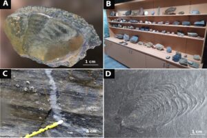
Figure 2. A) Virtual 3D model of a pygidium of the trilobites Asaphellus cf. toledanus. B) Dynamic fossil collection without glass cabinet. C) Detail of a large fossiliferous boulder with Devonian crinoids shown at the gardens of Folgoso do Courel tourism office. D) Deformed Neseuretus sp. found in Ordovician slate. This specimen links the Paleontological Heritage and the deformation caused by the Courel recumbent fold (Global Geosite) of the Geopark.
Geoconservation
The palaeontological sites of the Geopark are protected by the Spanish Law 42/2007 of Natural Heritage and Biodiversity, and 79% of them by the European Natura 2000 network. The Courel Mountains UGGp neither promotes nor organizes visits to the paleontological sites to preserve their rare faunal associations. New fossils discovered by paleontologists and local people (especially quarrymen) are being studied by the Scientific Committee and exhibited at the tourism office of Folgoso do Courel (Fig. 2D) and at the Geological Museum of Quiroga. Site damage is not reported, and field evidence does not suggest any hypothetical natural processes or human uses that can affect the paleontological sites, except fires, which would affect rocks and fossils. Unfortunately, the geological heritage is not yet considered appropriate for firefighting actions by the Regional Government.
Summary
Throughout its short life, the Courel Mountains Geopark has managed its Palaeozoic palaeontological heritage, characterized by its low preservation but scientific interest. The management comprises the implementation of the palaeontological sites in a GIS database of the Geopark, the creation of fossil collections (exhibited without glass cabinets), virtual 3D models, publications, and the transportation of natural boulders with fossils up to specific points, such as tourist offices. At present, tourism and educational visits to the paleontological sites are not recommended. Additional paleontological research is necessary to increase knowledge of the paleontological heritage of the Geopark, especially related to Cambrian archaeocyathids. Fossil recovery is possible thanks to the cooperation of paleontologists and local people, including quarrymen from the significant local roofing slate industry.