Introduction
Geotourism research is intended to improve the value-added component of the geosite visitor experience (Hose 2006). The assessment of geoheritage assets, values and benefits enables a more holistic approach to geotourism, recognizing the connections between people, geoheritage and the landscape (Gordon 2018). Geotourism is appreciated and accepted as a useful tool for promoting natural and cultural heritage as well as fostering local and regional economic development (Kubalíková 2019). This underlines the importance of exploring geoheritage and geotourism potentials and values for the establishment of geoconservation strategies.
A geoconservation focus gives geotourism an overlap with other forms of natural heritage tourism such as ‘environmental’ and ‘nature-based’ (Hose 2012), but the main purpose is the conservation of geosites and geomorphosites through the implementation of specific inventory, evaluation, conservation and monitoring procedures (Henriques et al. 2011). Geoconservation research has been undertaken elsewhere on different geosites, mainly caves (Stephens et al. 2013; Guzmán & Fernández 2016; Larwood 2016; Murphy & Allshorn 2018; Lewis 2019; Tomić et al. 2019; Antić et al. 2019; Zafra-Otero et al. 2019; Gordon 2019) and loess geosites (Vasiljević et al. 2011; Solarska et al. 2013; Vasiljević et al. 2014; Dong et al. 2014; Marković et al. 2014). A crucial aspect of geoconservation is the ability to establish the sustainability of local development (Piranha et al. 2011), geo-knowledge (Farsani et al. 2014) and geoethical values (Peppoloni et al. 2019). Moreover, professional and responsible geoconservation management and continuous geodiversity monitoring are prerequisites for carrying out successful geotourism strategies (Gordon, 2018).
Karst landscapes and features are one of the most vulnerable (Williams 2008) and visited (Lobo 2013) geosites. Caves, gorges, canyons, karst springs, waterfalls and natural stone bridges are the main representatives of karst resources (Ruban 2018) and karst-based geotourism potential. However, due to their fragility, the conceptual frameworks of karst geotourism strategies must include protection, education and socio-economic perspective (Sánchez-Botello et al. 2018). Furthermore, the promotion of scientific, educational and aesthetic values of rare and unique karst geosites establishes an adequate starting point of the geotourist affirmation. Bearing in mind the many benefits that local people can derive from tourism, both marketing and spatial planning must be carefully implemented to bring sustainable and ethical concepts of prosperity to geotourism.
Natural Arch and Bridge Society defines natural arches as “rock exposures that have holes through them formed by the natural, selective removal of rock, leaving a relatively intact frame”. There are many different processes of erosion that can contribute to the natural, selective removal of rock. These processes usually only cause a natural arch to form when certain combinations of them act on a rock exposure of a specific shape. Water, gravity, and temperature fluctuation are the principal forces involved in carving natural arches out of rock (www.naturalarches.org). Furthermore, Ćalić-Lubojević (2000) argues that there are two theories on the genesis of the natural bridges. The first one was elaborated by Cvijić (1918) and relies on the former presence of a cave whose roof collapsed, leaving only tiny stone arches—natural bridges. The second theory refers to situations when a river flowing across a thin limestone ridge cannot entrench into the ridge but sinks at the contact and resurges on the other side (Petrović 1969).
The diversity of karst areas in eastern Carpathian Serbia enables numerous exploitations of geosites for geotourism development purposes. The main focus of this paper is to identify and evaluate natural stone bridges as important resources for the development of karst geotourism in eastern Serbia. Additionally, the paper mentions other karst features in the area which could enrich the geotourism offer in this part of the Carpathians. The results of the paper are of particular importance for tourism workers, management structures and decision makers, as well as for the local population and NGOs.
Study area
The Carpathian branches in eastern Serbia extend from the Timok and Crna rivers in the east to the Velika Morava River in the west and from the Balkan Mountains in the Nišava River basin in the south to the Danube in the north.
The explored geosites are positioned in the karst the environment of the Carpathians in eastern Serbia (Figure 1). The evaluation was conducted on seven selected natural stone bridges, which are the most representative and possess great potential for geotourism development. Table 1 provides detailed descriptions of the sites that are analyzed and evaluated in this paper. It can be observed that out of seven selected geosites, four are located in the Negotin municipality. Also, Rajska has the longest tunnel (155 m), because it is a cave that has the characteristics of a natural stone bridge. Moreover, it is evident that Valja stone bridge near Majdanpek is the highest (44.8 m), which indicates its aesthetic uniqueness while the smallest natural stone bridge is Osanica, which can be very attractive for adventure tourists.
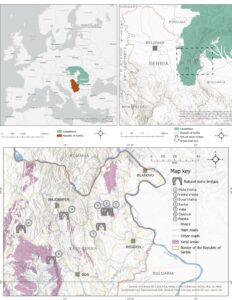
Figure 1. Location of analyzed stone bridges and the spread of karst areas in Carpathian Serbia
In addition, there are numerous caves in this area that are already developed speleotouristic destinations, such as Resava cave, Rajkova cave, Lazareva cave, Ceremošnja and Ravništarka caves. Numerous waterfalls are also found in this karst area: Buk, Siga, Blederije, as well as many gorges, canyons and paleo-volcanic sites.
Table 1. Natural stone bridges in Eastern Serbia
Natural Stone Bridges in Eastern Serbia | Municipality | Length (m) | Width (m) | Height (m) |
MalaVratna | Negotin | 15 | 33 | 34 |
VelikaVratna | Negotin | 45 | 22–33 | 26 |
SuvaVratna | Negotin | 34 | 20 | 15 |
Samar | Žagubica | 10 | 14 | 15 |
Valja | Majdanpek | 26 | 9.7 | 44.8 |
Osanica | Žagubica | 18 | 3 | 1–3 |
Rajska | Negotin | 155 | 18 | 18 |
Vratna River Stone Bridges are located in the Vratna canyon in eastern Serbia, more precisely about 30 km from the city of Negotin. The Vratna canyon can be reached via the Negotin-Kladovo road leading to the Vratna monastery and three stone bridges that cover a watercourse of 94 m in length (Tomić 2016).
The area of the Vratna River, which is cut in limestones, used to be a large cave with the main channel about 150 m long. It was through this channel that the Vratna River flowed. The simultaneous existence of surface and underground watercourses were connected by numerous sinkholes. While the underground flow was constantly active, the surface only existed occasionally, during the wetter period of the year when the underground cavities could not receive all the water. Due to the surface denudation (lowering of the surface area) and the simultaneous increase in the dimensions of the cave channel, or due to its expansion, the cave ceiling collapsed over a distance of about 100 meters, leaving only two specific limestone ports today called Mala (small) stone bridge and Velika (big) stone bridge (Petrović & Gavrilović 1969).
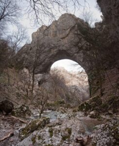
Figure 2. Mala Vratna stone bridge
Mala Vratna stone bridge is located about 200 meters upstream of the Vratna Monastery. The bridge is 15 m long, 33 m wide and 34 m high (Figure 2). The Velika Vratna stone bridge (Figure 3) is located 100 meters upstream of the Mala stone bridge and it has an opening in the form of a tunnel 45 m long, 22–33 m wide and 26 m high. There are more openings of cave channels on the walls and ceiling. The largest and longest cave system is located in the right wall and represents a maze of channels at different levels and heights (Tomić 2016). Suva Vratna stone bridge is not a part of the Vratna protected area and is approximately three kilometers from the previous two stone bridges. It is quite inaccessible, but the marked trail is extremely attractive to all adventurer tourists (Figure 4). This imposing and final stone bridge of the Vratna area is 34 m long, 20 m wide and 15 m high (Petrović & Gavrilović 1969).
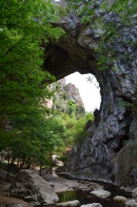
Figure 3. Velika Vratna stone bridge
The Vratna Canyon is protected by the Institute for Nature Conservation of Serbia as a natural monument. The protected area encompasses the river canyon on either side of the river bed. The Vratna canyon also has a very specific flora dating back to the Ice Age, as well as about 50 bird species and mammal species such as mouflon and musk deer (Petrović & Gavrilović 1969).
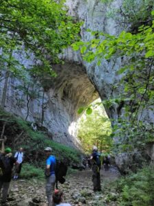
Figure 4. Suva Vratna stone bridge
Samar Stone Bridge. This natural bridge is located on the border of Homolje and Kučaj mountains, near the small city of Žagubica. The Samar stone bridge karst formation (Figure 5) is in the limestones of the easternmost part of Beljanica Mountain. Also, the Borsko Lake is only 12.5 km south of this geosite. The Ravna River flows through the Samar stone bridge, in a west-east direction. The length of this natural bridge is 10 m, while the width is 14 m and its height is 15m (Cvijić 1918). The Samar Geomorphologic Nature Monument was protected in 1979.
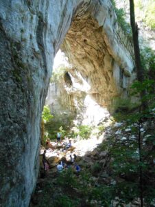
Figure 5. Samar stone bridge
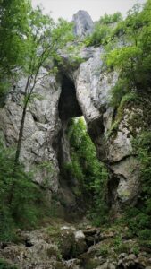
Figure 6. Valja stone bridge
Valja Stone Bridge.
The natural stone bridge Valja (Figure 6) is protected by the state as a natural monument of exceptional importance. The bridge is located about 12 km from Majdanpek. From a regional road Majdanpek-Rudna Glava a 1300m long pedestrian track leads to this geosite. The impressive height of the bridge is 44.8m, making it the highest in Serbia, while the width of its opening at the bottom is 9.7m. The protected area also includes a mountain river of the same name that runs below the stone bridge. Together they make an attractive and very significant geotourism destination (Gavrilović 2005).
The Osanica Stone Bridge. This geositeis in the north western part of Homolje Mountains, in the narrowest part of the Osanica epigenetic gorge. It is 2 km upstream of the Osanica River. The total length of this stone bridge is 18 m and the height of the vault varies from 1 m up to 3 m, while the average width is 3 m (Figure 7).
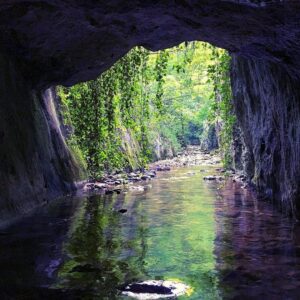
Figure 7. Osanica stone bridge
The thickness of the stone vault is 5 m below which the Osanica River flows. Due to its proximity to Osanica village, it is very accessible to all visitors. The macadam road along the river leads to the stone bridge, but for the last few tens of meters the stone bridge can only be reached by walking into the river. Therefore, the stone bridge can only be reached when the water level is low.
Rajska Stone Bridge. This geosite is located in the valley of the Zamna River, close to the Plavna village, which belongs to the municipality of Negotin. Zamna River Canyon and the stone bridge are both protected as a natural monument, but it should be emphasized that Rajska is also a tunnel cave. The river flows through a 155 m long cave with bridges at both sides (Figure 8). Water erosion has created openings in the cave vault through which daylight reaches almost its entire length (Gavrilović 1998).
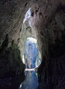
Figure 8. Rajska stone bridge
Methodology
The methodology of this study is based upon the ‘Modified GeositeAssessment Model’ (M-GAM), as developed by Tomić & Božić (2014). This method is mainly based on the Importance factor (Im) first introduced by Tomić (2011) and the GAM model created by Vujičić et al. (2011). The method is also based on previous geosite assessment methods developed by different researchers (Bruschi & Cendrero 2005; Coratza & Giusti 2005; Erhartič 2010; Hose 1997; Pereira et al. 2007; Pralong 2005; Reynard 2008; Reynard et al. 2007; Serrano & González-Trueba 2005; Tomić 2011; Zouros 2007). It combines the opinions of both sides of the tourism experience, tourists and experts, in such a way that neither side is favored in the assessment process. It has been successfully tested and applied numerous times for the assessment of various geosites in Serbia (Antić & Tomić 2017; Boškov et al. 2015; Božić et al. 2014; Božić & Tomić 2015; Tomić et al. 2019; Tomić et al. 2020; Vukoičić et al. 2018; Antić et al. 2019; Antić & Tomić 2019; Vuković & Antić 2019), Slovenia (Tičar et al. 2018), the USA (Tomić et al. 2015; Jonić 2018), Iran and in the Hungarian Bakony-Balaton geopark (Pál & Albert 2018).
The M-GAM model consists of two key indicators: Main Values and Additional Values, which are further divided into 12 and 15 indicators respectively, each individually marked from 0 to 1. This division is made due to two general kinds of values: Main Values - that are mostly generated by geosite’s natural characteristics; and Additional Values - that are mostly human-induced and generated by modifications for a geosite’s use by visitors. The Main Values comprise three groups of indicators: scientific/educational (VSE), scenic/aesthetic values (VSA) and protection (VPr) while the Additional Values are divided into two groups of indicators, functional (VFn) and touristic values (VTr). The Main and Additional Values are presented in more detail in Table 2.
The evaluation process is based on careful consideration of the different characteristics of investigated speleological objects. With the help of field research (visiting each geosite), scientific, aesthetic, conservation, tourist and functional parameters related to the M-GAM subindicators were observed in order to determine the current state and perspectives of tourism development of each geosite.
Table 2. The structure of the Modified Geosite Assessment Model (M-GAM)
Indicators/Subindicators | Description | |||||
Main values (MV) |
| |||||
Scientific/Educational value (VSE) |
| |||||
| The number of closest identical sites | |||||
| Didactic and exemplary characteristics of the site due to its quality and general configuration | |||||
| The number of written papers in acknowledged journals, thesis, presentations and other publications | |||||
| Level of interpretive possibilities on geological and geomorphologic processes, phenomena and shapes and level of scientific knowledge | |||||
Scenic/Aesthetic (VSA) |
| |||||
| The number of viewpoints accessible by a pedestrian pathway. Each must present a particular angle of view and be situated less than 1 km from the site. | |||||
| The whole surface of the site. Each site is considered in quantitative relation to other sites | |||||
| Panoramic view quality, presence of water and vegetation, absence of human-induced deterioration, vicinity of urban area, etc. | |||||
| Level of contrast to nature, the contrast of colors, the appearance of shapes, etc. | |||||
Protection (VPr) |
| |||||
| The current state of geosite | |||||
| Protection by local or regional groups, national government, international organizations, etc. | |||||
| Vulnerability level of geosite | |||||
| Proposed number of visitors on the site at the same time, according to the surface area, vulnerability and the current state of geosite | |||||
Additional values (AV) |
| |||||
Functional values (VFn) |
| |||||
| Possibilities of approaching to the site | |||||
| The number of additional natural values in the radius of 5 km (geosites also included) | |||||
| The number of additional anthropogenic values in the radius of 5 km | |||||
| Closeness of emissive centers | |||||
| Closeness of important road networks in the in the radius of 20 km | |||||
| Parking lots, gas stations, mechanics, etc. | |||||
Touristic values (VTr) |
| |||||
| Level and the number of promotional resources | |||||
| The annual number of organized visits to the geosite | |||||
| Closeness of visitor center to the geosite | |||||
| Interpretative characteristics of text and graphics, material quality, size, fitting to surroundings, etc. | |||||
| The annual number of visitors | |||||
| Level of additional infrastructure for tourist (pedestrian pathways, resting places, garbage cans, toilets etc.) | |||||
| If exists, expertise level, knowledge of foreign language(s), interpretative skills, etc. | |||||
| Hostelry service close to geosite | |||||
| Restaurant service close to geosite | |||||
Grades (0.00–1.00) | ||||||
| 0.00 | 0.25 | 0.50 | 0.75 | 1.00 | |
1. | Common | Regional | National | International | The only occurrence | |
2. | None | Low | Moderate | High | Utmost | |
3. | None | Local publications | Regional publications | National publications | International publications | |
4. | None | Moderate level of processes but hard to explain to non experts | Good example of processes but hard to explain to non-experts | Moderate level of processes but easy to explain to common visitor | Good example of processes and easy to explain to common visitor | |
5. | None | 1 | 2 to 3 | 4 to 6 | More than 6 | |
6. | Small | - | Medium | - | Large | |
7. | - | Low | Medium | High | Utmost | |
8. | Unfitting | - | Neutral | - | Fitting | |
9. | Totally damaged (as a result of human activities) | Highly damaged (as a result of natural processes) | Medium damaged (with essential geomorphologic features preserved) | Slightly damaged | No damage | |
10. | None | Local | Regional | National | International | |
11. | Irreversible (with possibility of total loss) | High (could be easily damaged) | Medium (could be damaged by natural processes or human activities) | Low (could be damaged only by human activities) | None | |
12. | 0 | 0 to 10 | 10 to 20 | 20 to 50 | More than 50 | |
13. | Inaccessible | Low (on foot with special equipment and expert guide tours) | Medium (by bicycle and other means of man-powered transport) | High (by car) | Utmost (by bus) | |
14. | None | 1 | 2 to 3 | 4 to 6 | More than 6 | |
15. | None | 1 | 2 to 3 | 4 to 6 | More than 6 | |
16. | More than 100 km | 100 to 50 km | 50 to 25 km | 25 to 5 km | Less than 5 km | |
17. | None | Local | Regional | National | International | |
18. | None | Low | Medium | High | Utmost | |
19. | None | Local | Regional | National | International | |
20. | None | Less than 12 per year | 12 to 24 per year | 24 to 48 per year | More than 48 per year | |
21. | More than 50 km | 50 to 20 km | 20 to 5 km | 5 to 1 km | Less than 1 km | |
22. | None | Low quality | Medium quality | High quality | Utmost quality | |
23. | None | Low (less than 5000) | Medium | High (10 001 to 100 000) | Utmost (more than 100 000) | |
24. | None | Low | Medium | High | Utmost | |
25. | None | Low | Medium | High | Utmost | |
26. | More than 50 km | 25–50 km | 10–25 km | 5–10 km | Less than 5km | |
27. | More than 25 km | 10–25 km | 10–5 km | 1–5 km | Less than 1 km | |
In total sum, there are 12 subindicators of Main Values, and 15 subindicators of Additional Values, which are graded from 0 to 1 that define M-GAM as a simple equation:
M-GAM = MV + AV (1)
where MV and AV represent symbols for Main and Additional Values. Since Main and Additional Values consist of three or two groups of subindicators, we can derive these two equations:
MV = VSE + VSA + VPr, (2)
AV = VFn + VTr, (3)
Now that we know that each group of indicators consists of several subindicators, equations (2) and (3) can be written as follows:
(4) and (5)
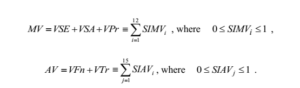
Here, SIMVi and SIAVj represent 12 subindicators of Main Values(i = 1,...,12) and 15 subindicators (j = 1,...,15) of Additional Values.
The main feature of M-GAM is that it does not focus only on the expert’s opinion but also on the opinion of visitors and tourists regarding the importance of each indicator in the assessment process. Visitor inclusion in the assessment process is done through a survey where each respondent is asked to rate the importance (Im) of all 27 subindicators (from 0.00 to 1.00) in the M-GAM model (Table 3). The importance factor (Im) was first introduced by Tomić (2011) in his research and later used for the creation of the M-GAM model, CREM model (Cultural Route Evaluation Model) created by Božić & Tomić, 2016 and SAM Model (Spa Assessment Model) created by Tomić & Košić, 2020. It gives visitors the opportunity to express their opinion about each subindicator in the model and how important it is for them when choosing and deciding between several geosites that they wish to visit. After each respondent rates the importance of every subindicator, the average value of each subindicator is calculated and the final value of that subindicator is the importance factor. Afterwards, the value of the importance factor (Im) is multiplied with the value that was given by experts (also from 0.00 to 1.00) who evaluate the current state and value of each subindicator (Table 3).
This is done for each subindicator in the model after which the values are added up according to the M-GAM equation but this time with more objective and accurate results due to the addition of the importance factor (Im). This parameter is determined by visitors who rate it in the same way as experts rate the subindicators for Main and Additional Values by giving them one of the following numerical values: 0.00, 0.25, 0.50, 0.75 and 1.00, marked as points. The importance factor (Im) is defined, as:
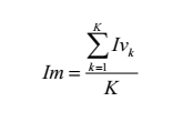 (6)
(6)
Where Ivk is the assessment/score of one visitor for each subindicator and K is the total number of visitors. Note that the Im parameter can have any value in the range from 0.00 to 1.00.
Finally, the M-GAM equation is defined and presented in the following form:
M - GAM = MV + AV (7)
(8) and (9)
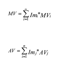
As it can be seen from the M-GAM equation, the value of the importance factor (Im), which is rated by visitors (for each subindicator separately) is multiplied with the value given by experts (also separately for each subindicator). This is done for each subindicator in the model.
In their research about different geotouristic segments, Božić & Tomić (2015) conducted a survey and calculated the importance factor for each subindicator in the M-GAM model. Their research was carried out in order to calculate the importance factor for Serbian geotourists. Since then, these values have been used numerous times for the assessment of different geosites in Serbia for the needs of Serbian tourists (Antić & Tomić 2017; Tomić et al. 2019; Tomić et al. 2020; Antić et al. 2019; Antić & Tomić 2019; Vuković & Antić 2019) and therefore can be applied in this case as well given the fact that the assessment is also done for Serbian tourists. Therefore, the values of the importance factor in this paper have been adopted from the mentioned paper.
Based on the assessment results, a matrix of Main (X axes) and Additional Values (Y axes) is created (Figure 9). The matrix is divided into nine fields represented with Z(i,j), (i,j=1,2,3). Depending on the final score, each geosite will fit into a certain field. For example, if a geosite's Main Values are 7 (X axes) and additional are 4 (Y axes), the geosite will fit into the Z21field at the point where these two values (7 and 4) meet.
.jpg)
Figure 9. Position of analyzed geosites in the M-GAM matrix
Results and Discussion
Considering the vastness of karst terrain in the eastern Carpathian region of Serbia (Figure 1), natural stone bridges are most certainly a regional phenomenon. The Carpathian region in Serbiais an area with the largest number of these geosites, which points out a unique advantage that can be utilized in the tourism market. Due to these facts, all natural stone bridges are rated 0.50 for the rarity subindicator. Moreover, the representativeness of the explored geosites was assessed more diversely. The utmost values (1.00) are given to the Velika Vratna, Valja stone bridge and Rajska stone bridge geosites while high values (0.75) are given to all other geosites, except Osanica, which received a moderate value of 0.50. This is the result of various attractive features. The best rated geosites have larger dimensions, which also affects the level of visits they receive. Furthermore, the interpretation subindicator is highly rated for all geosites, because the possibility of presenting it to potential tourists is high. There are the good examples of processes that are easy to explain to a common visitor. Although scientific research and publications related to the knowledge of these geosites are very scarce, the natural stone bridges in the Vratna river basin have been explored and papers have been published on this topic in international journals (Ćalić-Ljubojević 2000; Petrović & Carević 2015) while for other sites this is not the case.
The evaluation results for aesthetic values are very similar for all geosites. The natural stone bridges in the Vratna river basin have higher ratings because they possess a larger number of viewpoints compared to other geosites. The area covered by the explored geosites is also similarly evaluated. The majority of the geosites have medium size, while Rajska as the largest and Osanica stand out as the smallest. Considering the researched geosites, it is evident that these localities are unique for the Carpathian region of Serbia. Thus, they are authentic representative tourist potentials for this area. Given the uniqueness of the natural environment in which these geosites are located, they are all rated with maximum score when it comes to subindicators of landscape, nature and environmental fitting. Furthermore, all natural stone bridges are protected at the national level by the Institute for Nature Conservation of Serbia and have no major damage. According to the presented data and results for the Main Values, we can conclude that these geosites possess significant geotourism potential that could be used for the creation of an attractive geotourism destination. Therefore, it is necessary to explore the functional, infrastructural and tourist values to determine the measures for the creation, improvement and modernization of the potential geotourism product.
Table 3.Subindicator values given by experts for Natural Stone Bridges in Eastern Serbia
Main indicators/Subindicators | Geosites | Total value | ||||||||||||||
G1 | G2 | G3 | G4 | G5 | G6 | G7 | Im | G1 | G2 | G3 | G4 | G5 | G6 | G7 | ||
I Scientific/Educational values (VSE) |
| |||||||||||||||
Rarity (SIMV1) | 0.50 | 0.50 | 0.50 | 0.50 | 0.50 | 0.50 | 0.50 | 0.89 | 0.44 | 0.44 | 0.44 | 0.44 | 0.44 | 0.44 | 0.44 | |
Representativeness (SIMV2) | 0.75 | 1.00 | 0.75 | 0.75 | 1.00 | 0.50 | 1.00 | 0.79 | 0.59 | 0.79 | 0.59 | 0.59 | 0.79 | 0.39 | 0.79 | |
Knowledge on geo-scientific issues (SIMV3) | 1.00 | 1.00 | 1.00 | 0.00 | 0.25 | 0.00 | 0.00 | 0.45 | 0.45 | 0.45 | 0.45 | 0.00 | 0.11 | 0.00 | 0.00 | |
Level of interpretation (SIMV4) | 1.00 | 1.00 | 1.00 | 1.00 | 1.00 | 1.00 | 1.00 | 0.85 | 0.85 | 0.85 | 0.85 | 0.85 | 0.85 | 0.85 | 0.85 | |
II Scenic/Aesthetic values (VSA) |
| |||||||||||||||
Viewpoints (each must present a particular angle of view) (SIMV5) | 0.75 | 0.75 | 0.75 | 0.25 | 0.25 | 0.25 | 0.25 | 0.79 | 0.59 | 0.59 | 0.59 | 0.19 | 0.19 | 0.19 | 0.19 | |
Surface (each considered in quantitative relation to other) (SIMV6) | 0.50 | 0.50 | 0.50 | 0.50 | 0.50 | 0.00 | 1.00 | 0.54 | 0.27 | 0.27 | 0.27 | 0.27 | 0.27 | 0.00 | 0.54 | |
Surrounding landscape and nature (SIMV7) | 1.00 | 1.00 | 1.00 | 1.00 | 1.00 | 1.00 | 1.00 | 0.95 | 0.95 | 0.95 | 0.95 | 0.95 | 0.95 | 0.95 | 0.95 | |
Environmental fitting of sites (SIMV8) | 1.00 | 1.00 | 1.00 | 1.00 | 1.00 | 1.00 | 1.00 | 0.68 | 0.68 | 0.68 | 0.68 | 0.68 | 0.68 | 0.68 | 0.68 | |
III Protection (VPr) |
| |||||||||||||||
Current condition (SIMV9) | 1.00 | 1.00 | 1.00 | 1.00 | 1.00 | 1.00 | 1.00 | 0.83 | 0.83 | 0.83 | 0.83 | 0.83 | 0.83 | 0.83 | 0.83 | |
Protection level (SIMV10) | 0.75 | 0.75 | 0.75 | 0.75 | 0.75 | 0.75 | 0.75 | 0.76 | 0.57 | 0.57 | 0.57 | 0.57 | 0.57 | 0.57 | 0.57 | |
Vulnerability (SIMV11) | 0.75 | 0.75 | 0.75 | 0.75 | 0.75 | 0.75 | 0.75 | 0.58 | 0.43 | 0.43 | 0.43 | 0.43 | 0.43 | 0.43 | 0.43 | |
Suitable number of visitors (SIMV12) | 1.00 | 1.00 | 1.00 | 1.00 | 1.00 | 0.25 | 1.00 | 0.42 | 0.42 | 0.42 | 0.42 | 0.42 | 0.42 | 0.10 | 0.42 | |
Additional indicators/Subindicators |
| |||||||||||||||
I Functional values (VFn) |
| |||||||||||||||
Accessibility (SIAV1) | 0.75 | 0.75 | 0.75 | 0.25 | 0.75 | 0.25 | 0.25 | 0.75 | 0.56 | 0.56 | 0.56 | 0.18 | 0.56 | 0.18 | 0.18 | |
Additional natural values (SIAV2) | 1.00 | 1.00 | 1.00 | 1.00 | 1.00 | 1.00 | 1.00 | 0.71 | 0.71 | 0.71 | 0.71 | 0.71 | 0.71 | 0.71 | 0.71 | |
Additional anthropogenic values (SIAV3) | 0.25 | 0.25 | 0.25 | 0.00 | 0.00 | 0.00 | 0.25 | 0.70 | 0.17 | 0.17 | 0.17 | 0.00 | 0.00 | 0.00 | 0.17 | |
Vicinity of emissive centres(SIAV4) | 0.25 | 0.25 | 0.25 | 0.75 | 0.75 | 0.25 | 0.50 | 0.48 | 0.12 | 0.12 | 0.12 | 0.36 | 0.36 | 0.12 | 0.24 | |
Vicinity of the important road network (SIAV5) | 0.25 | 0.25 | 0.25 | 0.25 | 0.25 | 0.25 | 0.25 | 0.62 | 0.15 | 0.15 | 0.15 | 0.15 | 0.15 | 0.15 | 0.15 | |
Additional functional values (SIAV6) | 0.25 | 0.25 | 0.25 | 0.25 | 0.25 | 0.25 | 0.25 | 0.59 | 0.14 | 0.14 | 0.14 | 0.14 | 0.14 | 0.14 | 0.14 | |
II Tourist values (VTr) |
| |||||||||||||||
Promotion (SIAV7) | 0.50 | 0.50 | 0.50 | 0.25 | 0.50 | 0.25 | 0.00 | 0.85 | 0.42 | 0.42 | 0.42 | 0.21 | 0.42 | 0.21 | 0.00 | |
Annual number of organised visits (SIAV8) | 0.25 | 0.25 | 0.25 | 0.00 | 0.25 | 0.00 | 0.00 | 0.56 | 0.14 | 0.14 | 0.14 | 0.00 | 0.14 | 0.00 | 0.00 | |
Vicinity of visitors centres (SIAV9) | 0.00 | 0.00 | 0.00 | 0.00 | 0.00 | 0.00 | 0.00 | 0.87 | 0.00 | 0.00 | 0.00 | 0.00 | 0.00 | 0.00 | 0.00 | |
Interpretive panels (SIAV10) | 0.25 | 0.25 | 0.25 | 0.25 | 0.25 | 0.25 | 0.25 | 0.81 | 0.20 | 0.20 | 0.20 | 0.20 | 0.20 | 0.20 | 0.20 | |
The annual number of visitors (SIAV11) | 0.25 | 0.25 | 0.25 | 0.00 | 0.25 | 0.00 | 0.00 | 0.43 | 0.10 | 0.10 | 0.10 | 0.00 | 0.10 | 0.00 | 0.00 | |
Tourism infrastructure (SIAV12) | 0.25 | 0.25 | 0.25 | 0.00 | 0.25 | 0.00 | 0.00 | 0.73 | 0.18 | 0.18 | 0.18 | 0.00 | 0.18 | 0.00 | 0.00 | |
Tour guide service (SIAV13) | 0.00 | 0.00 | 0.00 | 0.00 | 0.00 | 0.00 | 0.00 | 0.87 | 0.00 | 0.00 | 0.00 | 0.00 | 0.00 | 0.00 | 0.00 | |
Hostelry service (SIAV14) | 0.25 | 0.25 | 0.25 | 0.50 | 0.75 | 1.00 | 0.25 | 0.73 | 0.18 | 0.18 | 0.18 | 0.36 | 0.54 | 0.73 | 0.18 | |
Restaurant service (SIAV15) | 0.00 | 0.00 | 0.00 | 0.25 | 0.75 | 1.00 | 0.00 | 0.78 | 0.00 | 0.00 | 0.00 | 0.19 | 0.58 | 0.78 | 0.00 | |
G1—Mala Vratna; G2—Velika Vratna; G3—Suva Vratna; G4—Samar; G5—Valja; G6—Osanica; G7—Rajska | ||||||||||||||||
Additional values of the analyzed geosites are significantly lower than the Main Values. Apart from the Vratna andValjа stone bridge near the Đerdap National Park, accessibility is low for each of the analyzed sites. Walking with special equipment and expert guide tours is mandatory for safe access to the explored sites. This is the primary reason that these sites have few visitors, because most tourists require adequate tourist infrastructure. On the other hand, this is an advantage for those tourists who enjoy adventurous trips to destinations that are completely free from conventional tourist activities. An appropriate solution is to provide both groups with quality conditions that will inspire them to visit these destinations continuously. This would mean arranging a part of the site, which is in the immediate vicinity of the stone bridges (access and information units), without changing the natural environment by opening large tourist complexes and camps.
The natural environment and surroundings are very diverse and attractive in this region. Near the Valja stone bridge Rajkova cave is located while near the Samar natural stone bridge the Borsko lake and paleovolcanic sites Tilva Njagra and Tilva Mika are located. Moreover, the famous speleotourism destination, Lazareva Cave and Lazar Canyon attract many visitors in this area. Due to these facts, it is clear that the subindicator of additional natural values received the highest grade. In addition, the Orthodox Christian monastery of Vratna is situated in the basin of the river Vratna and the Gornjak monastery is located near the Osanica stone bridge. Furthermore, archeological sites Lepenski Vir (prehistoric site) and Kraku Lu Jordan (Celtic site) are located near the Valja stone bridge geosite. With the exception of the Vratna monastery, all other anthropogenic values are not situated close enough (5 km radius) to the stone bridges. Thus, they can not be evaluated as crucial indicators for geotourism development. Nevertheless, these cultural destinations are important for the regional (geo)tourism affirmation, and they should be included in future tourism development strategies.
The proximity of emissive centers and important roads is not rated with the highest grades because all geosites are located within the limestone masses of the Carpathian region, distanced from larger cities and major highways or international roads. Thus, they are surrounded by local roads that are in poor condition. Additional values such as traffic and communal infrastructure, adequate tourist service and information units, accommodation and restaurant services are in very poor condition, and are rated poorly. However, some cases stand out. Valja and Osanica stone bridges have a higher rating for hostelry and restaurant services, because the service facilities are located within the 5 km radius from these geosites.
In conclusion, it can be determined with certainty that the biggest shortcoming related to geotourism development in the explored area is reflected in social and scientific-educational recognition of karst phenomena. Adequate utilization of geotourist interpretations, the lack of guide service and poor organization of management structures represent the major flaws regarding the current state of geotourism development. These factors crucially influence the current underdevelopment of the presented unique karst phenomena in the Carpathian region of eastern Serbia. It is necessary to pay more attention to authentic geological phenomena, and to modernly organize tourist development, in a modern sustainable way, following world trends and respecting the concepts of sustainable development and geoethical principles. A special advantage for the geotourism of natural stone bridges is the fact that the Đerdap National Park has officially become a member of the UNESCO Geopark Network since July 2020. This can have a positive impact on numerous geosites within this area, especially in the field of scientific and educational promotion of geoheritage and tourist affirmation. Nevertheless, it is necessary to improve the infrastructure related to traffic access and service activities and to include all interest groups that can have a great impact on the improvement and development of karst geoconservation. Nevertheless, it is necessary to improve the infrastructure related to traffic access and service activities and to include all interest groups that can have a great impact on the improvement and development of karst geoconservation. In that way, the long-term geotouristic exploitation, that will not endanger the karst environment and will not violate the natural integrity, can be established.
Table 4. shows the overall ranking of the analyzed geosites while Figure 9 shows that all of the analyzed geosites are located in the Z21 field of the M-GAM matrix. However, certain differences are still present. Stone bridges in the Vratna river basin, especially the Velika Vratna geosite (G2), have the highest final assessment of the main values. These results confirm that, although the destinations are not significantly developed, the Vratna River is a representative area of stone bridges in eastern Serbia. The fact that the three stone bridges are connected by the Vratna river indicates the effectiveness they can have in the (geo)tourism market. Furthermore, Rajska stone bridge (G7) also has a high rating of the Main Values which indicates that it is necessary to develop and implement a number of strategic and financial measures in order to develop basic tourism activities in this area. Only then can additional approaches be considered. Samar (G4) and Valja stone bridge (G5) geosites have similar final results of the Main Values. Valja and Vratna stone bridges (G1, G2, G3) have the most adequate conditions for the development of geotourism. A special advantage of the Valja stone bridge is the proximity of the speleotourist site Rajkova cave and the copper and gold mine, which is still not possible to visit, but can be observed from the local road that leads to the stone bridge. Samar geosite should be connected in terms of marketing and tourism with Lake Borsko and the paleovolcanic sites Tilva Njagra and Tilva Mika, that are located 13 km from the stone bridge. When all the parameters of the research are taken into account, it is evident that the stone bridges encompass a very rich geotourism content that reflects the geological and karst values of the Carpathian area in eastern Serbia.
Table 4. Overall ranking of the analyzed geosites by M-GAM
Geosites | Main Values | Σ | Additional Values | Σ | Field |
VSE + VSA + VPr | VFn + VTr | ||||
G1—Mala Vratna | 2.33 + 2.49 + 2.25 | 7.07 | 1.85 + 1.22 | 3.07 | Z21 |
G2—Velika Vratna | 2.53 + 2.49 + 2.25 | 7.27 | 1.85 + 1.22 | 3.07 | Z21 |
G3—Suva Vratna | 2.33 + 2.49 + 2.25 | 7.07 | 1.85 + 1.22 | 3.07 | Z21 |
G4—Samar | 1.88 + 2.09 + 2.25 | 6.22 | 1.54 + 0.96 | 2.50 | Z21 |
G5—Valja | 2.19 + 2.09 + 2.25 | 6.53 | 1.92 + 2.16 | 4.08 | Z21 |
G6—Osanica | 1.68 + 1.82 + 1.93 | 5.43 | 1.30 + 1.92 | 3.22 | Z21 |
G7—Rajska | 2.08 + 2.36 + 2.25 | 6.69 | 1.59 + 0.38 | 1.97 | Z21 |
Тhe rating of Additional Values does not coincide with the rating of the Main Values. Valja stone bridge (G5) has the highest score of additional values while the stone bridges in the Vratna river basin do not have the necessary quality of Additional Values that would position them on a higher quality field of the M-GAM matrix. Osanica (G6) has a higher score of Additional Values compared to Vratna stone bridges. This data indicates that urgent management intervention is necessary in order to better protect the Vratna stone bridges and use them for sustainable geotourism purposes. Samar and Rajska stone bridges have the lowest ratings, so their geotourism affirmation cannot be professionally considered before further recognition of these geosites on the tourist market. It is necessary to pay a lot of attention to marketing strategies, which is the case with all geosites. Тhe jurisdiction should be given to a single organization over karst areas, which would deal with the protection and implementation of measures necessary for geotourism and speleotourism development in Serbia. In addition, initiating and involving all stakeholders, governmental and non-governmental organizations for the more advanced development of geotourism is also necessary. Numerous scientific, ecological, sports and volunteer societies can contribute a lot to the protection and sustainability of the karst natural environment. The scientific-educational community continuously needs to conduct various explorations.They need to be allowed to do this because they promote the values of karst for both, scientific and tourist needs. Ecological societies are important for the practical and quality application of sustainable concepts and values of geoconservation, while sports organizations, mountaineers and speleologists can have a very important influence on the training of tour guides who will lead tourists through karst areas. Therefore, a joint effort with the support of the local population can enable a quality, economically viable and sustainable concept of geotourism development.
ConclusionThe results of this paper indicate the current state and future perspectives of a unique karst phenomenon, the natural stone bridges. By evaluating seven representative geosites, the final results of the research were obtained. The best rated aesthetic, scientific-educational and protection values belong to the natural stone bridges in the Vratna river basin (G1, G2, G3), not far from the town of Negotin. However, low Additional Values indicate that the primary focus in the future should be the construction of basic tourism infrastructure along with promotional activities and tour guide service. On the other hand, the highest score of Additional Values belongs to Valja (G5) and Osanica (G6) stone bridges. These seven geosites, together with complementary caves, waterfalls and karst springs are very important places that encompass the greatest preconditions for the development of karst-based geotourism. For this reason, they should be given the most attention in the initial stages of geotourism planning.
The explored unique karst geosites in Serbia possess exceptional qualities, aesthetic and scientific values that make up the tourist potentials that can effectively be converted into tourist values. In order to encourage the local economic development of the Carpathian area in Serbia, these karst geotourism resources should be used to the maximum, by applying measures, concepts and principles of sustainable geotourism development and respecting the opinion and attitudes of the local population (Hose, 2006). Marketing strategies, financial management and professional staff must be a part of the basic changes in order to set visions and goals for the geotourism affirmation of the Carpathian karst environment.
Further research of Carpathian natural stone bridges and their geotourism affirmation should focus on the possibilities of regional tourist connection of the Carpathian region. Such regional geotourism development would also imply Romania (Podul Natural), Slovakia (Obrovska Brana, Okno Ohnište), the Czech Republic (Pravčička dam) and Poland (Diorama Arch), as potential carriers of the Carpathian natural stone bridges geotourism offer. However, such an endeavor requires detailed multidisciplinary research and projects that would connect different stakeholders in order to achieve the sustainable development of geotourism in this region of the world. The essence of such geotourism development would also be the promotion of intercultural and scientific cooperation in the field of tourism and geosciences.