Introduction
The Fossil Forest of the Aragoncillo Range is in central Spain, in the province of Guadalajara and the Molina-Alto Tajo UNESCO Global Geopark (Fig. 1). The site was declared representative of the Spanish Mesozoic paleontological heritage and of international relevance (Castro et al. 2008) and therefore was included in the Spanish proposal for the Global Geosites Project of the International Union of Geological Sciences (IUGS). This initiative aims to inventory the Earth's most significant geological heritage, including outcrops and geological frameworks, that allow study the long history of our planet (García-Cortés et al. 2008). The geopark has been a member of the European Geoparks Network (EGN) and of the Global Geoparks Network (GGN) since September 2014. This distinction is awarded to territories that contain an exceptional geological heritage (including paleontological), which must be preserved and used as a driving force for sustainable local development based on education and geotourism.
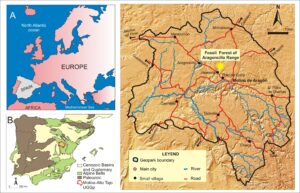
Figure 1. Geographical and geological setting of Fossil forest and Molina-Alto Tajo UNESCO Global Geopark. A) Location of Spain in southwestern Europe. B) Geology of the Iberian Peninsula. C) Location of the Fossil forest in the Molina-Alto Tajo UNESCO Global Geopark.
The geopark covers 4,186.9 km2 and has a population of 10,370 people, with a density of only 2 inhabitants per km2. It is therefore a very large and sparsely populated region, meeting all the conditions to be considered a European demographic desert. The region has an important geological heritage and geodiversity that covers a significant part of Earth history, from 480 million years ago. One of its most striking features is the preservation of fossil wood and other plant remains from the Lower Permian, 299 and 251 Ma (Cohen et al. 2013) when the supercontinent Pangea was completed and gradual climate change began, from humid tropical climate conditions in the Late Carboniferous and Early Permian to more arid conditions in the Middle Permian. Figure 2 shows the approximate position of the Iberian Peninsula during this time interval.
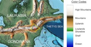
Figure 2. Location of the Iberian Peninsula during Lower Permian. The red circle represents the approximate position of the Molina de Aragón-Alto Tajo Region Geopark. (Modified from Scotese, 2016).
The Fossil Forest of the Aragoncillo Range shows a record of changes that took place in the ecosystems, in the form of an accumulation of fossil stumps, some in life position and others rolled and dispersed by erosion and redeposition. Rapid burial under different sediments and volcanic ashes facilitated the fossilization of the wood cells, the preservation of fronds of some plants, and good preservation of palynological associations of pollen and spores. The deposit yields data on the type flora of the region in the Early Permian, as well as on the evolution of the paleoclimate. Therefore, in addition to touristic interest, it is of great scientific interest for the reconstruction of an ecosystem that has disappeared.
Geological Setting
The Aragoncillo Range (also known as Selas Range) is a small mountainous range with an approximate NW-SE direction and located to the NW of Molina de Aragon (Fig. 3). It forms part of the broader Castilian Branch of the Iberian Mountain Range and, although its length does not exceed 20 km, some of its elevations, such as Aragoncillo, exceed 1500 m.
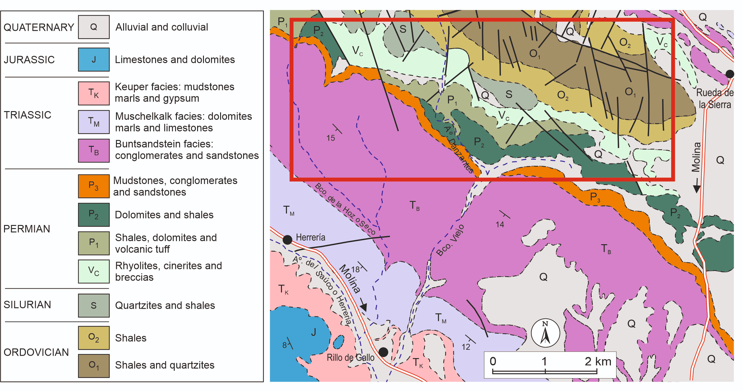
Figure 3. Main geological outcrops of the Aragoncillo Range.
From the geological point of view, the substrate of this mountain range consists of early Paleozoic slate, quartzite and some limestone, unconformably overlain by the Permian, and itself unconformably covered by a late Permian–Mesozoic sequence. The tectonic structure consists of a wide anticline with NW-SE axis where the early Paleozoic crops out, and with gently-dipping flanks of Permian and Triassic sedimentary rocks.
The first record of the Aragoncillo Paleozoic is by Calderón (1898), who described the units cropping out beneath the Triassic to the north of Rillo de Gallo (Fig. 3). He did not specify the age of the fossil forest, but includes the unit in the Carboniferous. Tricalinos (1928) classified a trunk of silicified wood as Dadoxylon sp., and thus of late Carboniferous age. Sacher (1966) maintained the same age and studied these rocks in detail, citing the first specimens of floral remains (Lebachia piniformis). He defined a unit that he called "Capas de la Ermita" (Hermitage Beds), in reference to the Hermitage of the Virgin of the Carrasca, whose ruins stand on Permian rocks. The latest details on the age of the Fossil Forest are from Ramos (1979), who found two palynological associations that indicated an Early Permian age. Some research provided new data on the palynological content and fossil wood specimens (Sopeña et al. 1995; Sopeña & Sánchez-Moya 1999), and on the geological characteristics of the area and their dissemination (Sopeña & Sánchez-Moya 2008; Sopeña & Sánchez-Moya 2017).
The Lower Permian rocks in which the Fossil Forest is located show a vertical succession of two well-differentiated lithological sections (Ramos 1979). The lower section covers the paleo-relief developed over the Paleozoic metamorphic units and is formed from volcanic, volcanoclastic and volcano-sedimentary rocks, while the upper section starts with limestones and ends with shales, sandstones, limestones and sandy dolostones (Fig. 4).
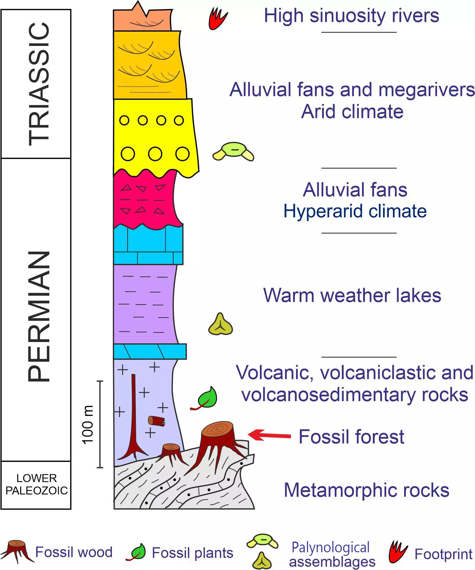
Figure 4. Permian stratigraphy of the Aragoncillo Range (Modified from Ramos 1979; Sopeña & Sanchez-Moya 2008).
Fossil Forest
Between the end of the Carboniferous and the beginning of the Permian, the territory of the geopark had a humid tropical climate with high temperatures and occasional heavy rainfall. Along with the mountains raised during the Variscan Orogeny, there were valleys and lower altitude areas where water was abundant and permanent lakes formed. From a sedimentological point of view, the entire region was dominated by an alluvial and lacustrine landscape receiving large quantities of pyroclasts and ash from volcanic activity (Ramos 1979). In this paleoenvironment, abundant vegetation was developed. Floral remains mainly consist of ferns (e.g., Scolecopteris oreopteridia, Lobatopteris geinitzii), pteridosperms (Odontopteris osmundaeformis, Odontopteris cf. bradii, Alethopteris sp.) and sphenopsids (Calamites sp., Annularia carinata, Calamostachys tuberculata); several callipterids (Autunia conferta, Rhachiphyllum sp., Gracilopteris sp.) and conifers (Culmitzschia parvifolia, Ernestiodendron filiciforme, Otovicia hypnoides) are also present but their remains are commonly fragmentary and poorly preserved (Fig. 5).
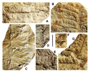
Figure 5. Fossil leaves from the Early Permian of the Aragoncillo Range. A) Odontopteris osmundaeformis (Schlotheim) Zeiller. B) Autunia conferta (Sternberg) Kerp. C) Annularia carinata Gutbier. D) Culmitzschia parvifolia (Florin) Kerp & Clement-Westerhof. E) Autunia conferta (Sternberg) Kerp. F) Alethopteris sp. G) Lobatopteris geinitzii (Gutbier) Wagner. Scale bar = 1 cm for all figured specimens.
Palynological associations have been found in the lacustrine shales (Ramos et al. 1976; Ramos 1979; Sopeña et al. 1995) and include a great diversity of forms including, among others, Cyclogranisporites pergranulus, Punctatisporites breviornatus, Lundbladispora gigantea, Potonieisporites novicus, Potonieisporites bhardwji, Potonieisporites simplex, Wilsonites delicatus, Jugaesporites sp., Gardenasporites delicatus, and Vittatina costabilis. (Fig.6). These associations are characteristic of many Lower Permian sites in Western Europe (Ramos et al. 1976).
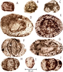
Figure 6. Some characteristic specimens of the Lower Permian palynological associations of Rillo de Gallo section. A) Cyclogranisporites pergranulus Alpern. B) Lundbladispora cf. gigantea (Alpern) Doubinger. C) Pityosporites cf. westphalensis Schemel. D) Potonieisporites novicus Bhardwaj. E) Potonieisporites novicus Bhardwaj. F) Kosankeisporites sp. G) Potonieisporites bhardwaji Remy. H) Alisporites sp. I) Vittatina sp. J) Jugasporites sp. (Modified from Ramos 1979).
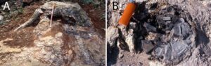
Figure 7. Tree trunks from the Early Permian of the Aragoncillo Range. A) Remains of a life position fossil trunk with roots that penetrate into the substrate. B) Aerial view of a small fossil trunk remains of life position
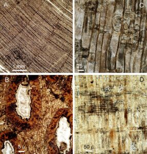
Figure 8. Photomicrographs of different sections in several specimens of fossil wood from the Early Permian of the Aragoncillo Range. A) View of a transverse section of the xylem, showing growth rings. B) Transverse section of primary vascular system, secretory ducts and resiniferous cells. C) Radial section showing tracheids and pitting. D) Transverse section of the xylem, showing the tracheids and rays.
The conservation of the abundant silicified trunks is directly related to the intense volcanic activity that took place at the beginning of the Permian. The preservation of some trunks in life position (Fig. 7) demonstrates exhumation of part of the original Permian deposit and long-lasting conditions favorable for fossilization of wood (Fig. 8). There is great variation of the rocks that contain most of the silicified plant remains, in the lower parts of the succession. Rocks of volcanic and volcaniclastic origin predominate, alternating with volcanic-sedimentary rocks that arose from remobilization of volcanic materials by the alluvial network that drained the region. It is not known where the original eruptions were located; perhaps they were dismantled by subsequent erosion or may be covered by Mesozoic and Tertiary sediments. The eruptions were explosive, acidic type (Fig. 9), with large amounts of pyroclasts, ash-flow and cinerites. Pyroclastic waves are flows with a mixture of hot gases and rocks that reach temperatures above 700 ºC and speeds of 50 m/s and that move over the ground with great destructive power and devastating effect (Fig. 10). Their ability to travel large distances on slopes as gentle as a few degrees has been attributed to non-equilibrium pore pressures and associated fluidization effects generated either by gases released internally or by entrainment of air (Sparks 1976; Wilson 1980; Druitt et al. 2007).
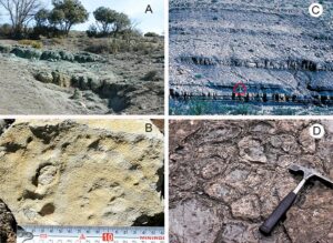
Figure 9. Sedimentology of the Early Permian of the Aragoncillo Range. A) Different well-developed ignimbrites and cinerites related to pyroclastic deposits, occur interbedded within terrigenous sediment deposits. B) Rhyolite rocks with pyroclastic pellets impact marks. C) Lake sediments containing palynological assemblages. D) Mud cracks at the top of lacustrine strata.
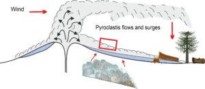
Figure 10. Recreation of volcanic episodes that wiped out and buried the Permian forest under successive pyroclastics surges and ashes.
Under these conditions, the vegetation that had grown over the unconformity separating the Lower Paleozoic from the Permian was cut down and the wood and leaves dragged away, deposited in nearby areas and fossilized (Fig. 11). Another process also occurs when the wood is destroyed before mineralization, producing an empty cavity and later filling this mold with mineral matter that preserves only the morphology of the outer surface (Fig. 12).
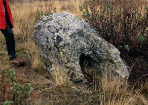
Figure 11. Remobilized fossil trunk.
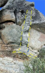
Figure 12. Silhouette of a trunk in life position and filled with pyroclastics.
Geotourism and Geotrail Potential
Geosites are geological resources with high value for scientific and touristic purposes (Gray 2005). In the last decade, interest in the history of our planet and the desire to visit places of high geological value, has increased significantly. Geotourism is a resource of high economic and social interest in development and has influenced various programs in rural areas (García-Ortiz et al. 2014). This has happened in Spain, where there has been a remarkable increase in UNESCO Global Geoparks in recent years. In this context, the Aragoncillo Range Fossil Forest has all the necessary elements to become an important geotouristic focus. Similar geosites in Spain that are good examples of the tourist use of fossil forests include Verdeña in the province of Palencia (Wagner & Díez 2007) and Hacinas in the province of Burgos (García-Esteban et al. 2006), which even has an exclusive interpretation center. Similar examples elsewhere in Europe are the Jurassic Forest of Dorset in England and the Miocene Forest of Lesbos in Greece. All of them help the regional economy and its development.
On the other hand, the Aragoncillo Fossil Forest is located in a beautiful natural environment associated with other geological, archeological and ethnographic elements of cultural interest. The Geopark has developed eleven self-guided geological interpretation routes and four interpretation centers of the Upper Tagus Natural Park (Saiz et al. 2015). A new georoute to visit the fossil forest could be added without difficulty as a route of excellent scientific, educational and touristic potential.
Geosite Protection, Conservation and Future Perspectives
Despite its high interest and its vulnerability, the Fossil Forest does not have specific protection, only generic, as offered by Law 4/2013 of Cultural Heritage of Castilla-La Mancha and by Law 9/1999 of Nature Conservation of Castilla-La Mancha (Wagner & Álvarez-Vázquez 2010). To preserve this site, special attention should be paid to protection of the tree trunks to prevent the permanent loss of this finite natural resource. Conservation and practical use of the paleontological resource requires accurate delimitation of the area and the location, as accurately as possible, of the elements that are exposed. In the first study of these features, Carcavilla et al. (2016) recognized four types of areas for different types of protection: 1) those that contain fossil specimens in situ; 2) those that contain fossil specimens that have been rolled over (moved from their original position) but are well preserved and with their original structure; 3) those that contain remains of flora; and 4) those that, although they do not have fossil specimens on the surface, might contain them and could be destroyed if the substrate is removed by aggressive forestry work.
Considering these definitions, it is necessary to establish different protection regimes and to delimit a perimeter of special maintenance, cleaning and surveillance, with protection measures against erosion and custody services that protect against abuse and vandalism. Finally, the cultural and scientific interest and the uniqueness of this site recommend a management plan of outreach actions, but they should never be initiated without first providing it with a legal and physical system of protection that guarantees its future.
Acknowledgments
This research was developed with the support of the Spanish Geological Survey (IGME) Project 2457: Improvement of knowledge of the geological heritage of Castilla-La Mancha. The authors thank the Friends of the Molina Museum Association for their help. Many people have been involved in the conservation of this site in recent years, such as Juan Manuel Monasterio, Mariano Valero, Miguel Aguilar, and the Friends of the Molina Museum Association itself. Thanks to all of them for their involvement in the conservation of this exceptional site.
References
Calderón S (1898). Existencia de terreno carbonífero Molina de Aragón. Actas Real Sociedad Española de Historia Natural. 27:147–150.
Carcavilla L, Sopeña A, Sánchez-Moya Y, Vegas J, Díez-Herrero A & Moratalla J (2016). Cartografía digital y valoración de los yacimientos paleontológicos amenazados de la sierra de Aragoncillo. Proyecto de Investigación del Patrimonio Arqueológico y Paleontológico. Comunidad de Castilla-La Mancha: Informe IGME.
Castro JM, García A, Gómez JJ, Goy A, Molina JM, Ruiz PA & Sopeña A (2008). Sucesiones mesozoicas de las cordilleras Bética e Ibérica, In Contextos geológicos españoles. Una aproximación al patrimonio geológico nacional de relevancia internacional (pp 73–90). Madrid: IGME.
Cohen KM, Finney SC, Gibbard PL & Fan JX (2013). The ICS International Chronostratigraphic Chart. Episodes. 36:199–204.
Druitt TH, Avard G, Bruni G, Lettieri, P & Maez F (2007). Gas retention in fine-grained pyroclastic flow materials at high temperatures. Bulletin of Volcanology. 69:881–901. doi:10.1007/s00445-007-0116-7
García-Esteban LG, de Palacios P, Philippe M, Guindeo A & Fernández, FG (2006). New xylological data and the biogeography of the Iberian Peninsula during the Early Cretaceous. Geobios. 39:805–816. doi:10.1016/j.geobios.2005.09.003
García-Cortés A, ed. (2008). Contextos geológicos españoles. Madrid: IGME.
García-Ortiz E, Fuertes-Gutiérrez I & Fernández-Martínez E (2014). Concepts and terminology for the risk of degradation of geological heritage sites: fragility and natural vulnerability, a case study. Proceedings of the Geologists' Association. 125:463–479.
Gray M (2005). Geodiversity and geoconservation: what, why, and how? In: The George Wright Forum. 22:4–12. George Wright Society.
Ramos A, Doubinger J & Virgili C (1976). El Pérmico inferior de Rillo de Gallo (Guadalajara). Acta Geológica Hispánica. 11:65–70.
Ramos A (1979). Estratigrafía y paleogeografía del Pérmico y Triásico al Oeste de Molina de Aragón (prov. de Guadalajara). Seminarios de Estratigrafía. Serie Monografías. 6, 313 pp.
Sacher L (1966). Stratigraphie und Tektonik der nordwestlichen Hesperischen Ketten bei Molina de Aragón/Spanien. Teil 1: Stratigraphie (Paläozoikum). Neues Jahrbuch für Geologie und Paläontologie, Abhandlungen. 124:151–167.
Saiz A et al. (2015). Guía turística del Geoparque de la Comarca de Molina-Alto Tajo. 300 pp. Asociación de Desarrollo Rural Molina de Aragón-Alto Tajo.
Scotese CR (2016). PALEOMAP PaleoAtlas for GPlates and the PaleoData Plotter Program, PALEOMAP Project.
Sopeña A, Doubinger J, Ramos A & Pérez-Arlucea M (1995). Palynologie du Permien et du Trias dans le centre de la Péninsule Ibérique. Sciences Géologiques Bulletin. 48:119–157. doi:10.3406/sgeol.1995.1926
Sopeña A & Sánchez-Moya Y (1999). El bosque petrificado de la Sierra de Aragoncillo. In: La huella del pasado. Fósiles de Castilla-La Mancha, Serie: Patrimonio Histórico. Arqueología. Castilla La Mancha. 16:125–135.
Sopeña A & Sánchez-Moya Y (2008). Pérmico y Triásico. In: Geología de Guadalajara. Obras colectivas Ciencias. 3: 95–107. UAH.
Sopeña A & Sánchez-Moya Y (2017). Un Bosque Fósil de hace 280 millones de años. Quercus. 377:62–65.
Sparks RSJ (1976). Grain size variations in ignimbrites and implications for the transport of pyroclastic flows. Sedimentology 23:147–188. doi:10.1111/j.1365-3091.1976.tb00045.x
Tricalinos J (1928). Untersuchungen über den Bau der Celtiberischen Ketten des nordöstlichen Spaniens. Zeitschrift der Deutschen Geologischen Gesellschaft. 80:409–482.
Wagner RH & Álvarez-Vázquez C (2010). The Carboniferous floras of the Iberian Peninsula: A synthesis with geological connotations. Review of Palaeobotany and Palynology. 162:239–324. doi:10.1016/j.revpalbo.2010.06.005
Wagner RH & Diez JB (2007). Verdeña (Spain): life and death of a Carboniferous forest community. Comptes Rendus Palevol. 6:495–504.
Wilson C (1980). The role of fluidization in the emplacement of pyroclastic flows: an experimental approach. Journal of Volcanology and Geothermal Research. 8:231–249.