Biological invasions form a major threat to the provision of ecosystems products and services and can affect ecosystems across a wide spectrum of bioclimatic conditions. Therefore, it is important to systematically monitor the spread of species over broad regions. It has long been recognized that remote sensing and geographical information system could contribute to this […]
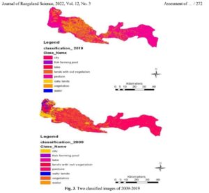
Land use may be regarded as one of the most important factors affecting the environment with respect to human activities. So far, destroying the rangelands and changing them into the waste lands and poor rangelands has been proposed as the most significant variations of land use done by human beings. This paper has been conducted […]
According to the fundamental goal of remote sensing technology, the image classification of desired sensors can be introduced as the most important part of satellite image interpretation. There exist various algorithms in relation to the supervised land use classification that the most pertinent one should be determined. Therefore, this study has been conducted to determine […]
Maharloo Lake is one of the salty lakes located in the southeast of Fars province, Iran. Presence of salt domes has a significant role in its salinity. Magnesium-sodium chloride and sodium sulfate are dominant salts of the lake. Due to the drying up of lake, widespread lands surrounding the area are exposed to secondary salinity. […]
The drought caused a series of effects on many sectors of economy, especially natural resources. During two last decades, Iran has suffered from several severe to extreme agricultural droughts which caused significant decreases in rangeland and agriculture yields. This paper discusses the detection of agricultural drought severity over the rangelands of Markazi Province between 2000 […]
Drought is a major problematic phenomenon mostly for semi-arid areas of Iran. During drought periods, reduction in vegetation levels causes such problems as soil erosion, surface runoff, flood risk, etc. Therefore, the assessment of drought effects on plant covers is the most important issue. This research was conducted in 2015 using the extracted vegetation indices […]
Soil salinity has concerned people in arid and semi-arid rangelands. One of the most essential cases in relation to information for natural resource managers is preparation of soil salinity maps. Developing such maps, using traditional methods spends a lot of time and costs. Satellite data have broadened and integrated our vision for this purpose. This […]
Reduction in vegetation cover and increasing land surface temperature are the most important consequences of drought which leads to land degradation. Therefore, the evaluation of drought effects on vegetation cover and its relationship with land surface temperature is very important. To that end, the objective of this study was to evaluate the relationship among vegetation […]
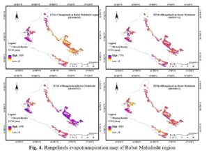
Ecological capability assessment of a land as one of the most important steps in line with sustainable development was conducted based on identifying and pre-designed criteria, following assessment of the land’s assets and its latent power. In the present study, which was conducted in 2019, in order to reveal the changes in the region during […]
Rangelands are the most important plant ecosystems in Iran that have multiple and vital roles in economic stability and food security in the country. In recent decades, with increasing population, increasing forage consumption, climate change and rainfall fluctuations, most of the country’s pastures have been destroyed or faced with a degradation trend. Therefore, in order […]