Soil erosion is a serious problem especially in northern parts of Iran. One the most important side effects on soil erosion may be the decline in qualities of soil refers to agricultural productivity. So it is very important to assess the soil erosion risk for the sustainable development of agriculture. This study outlines ways undertaken […]
Land use may be regarded as one of the most important factors affecting the environment with respect to human activities. So far, destroying the rangelands and changing them into the waste lands and poor rangelands has been proposed as the most significant variations of land use done by human beings. This paper has been conducted […]
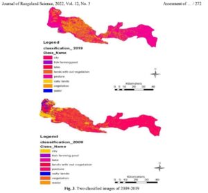
Due to the increase of changes in the land uses mainly resulting from human interferences, monitoring the changes and evaluating their trend and environmental effects for future planning and management are essential. In the present study, an attempt is made to observe the changes which had occurred in Ardestan area during a period of 30 […]
According to the fundamental goal of remote sensing technology, the image classification of desired sensors can be introduced as the most important part of satellite image interpretation. There exist various algorithms in relation to the supervised land use classification that the most pertinent one should be determined. Therefore, this study has been conducted to determine […]
This edited volume is devoted to the examination of the implications of the inevitable changes wrought by global change on the welfare and livelihoods of tens of millions of people who live in dryland regions. Global change is more than just climate change and the ramifications of changing trade patterns (geopolitical and economic aspects), the shift […]
Food security covers aspects at all spatial levels from local to global and from an interdisciplinary and systemic food systems perspective. This book aims to better understand environmental, nutritional, agricultural, demographic, socioeconomic, political, technological, and institutional drivers, costs, and outcomes of current and future food security. Interactions with contextual factors include climate change, urbanization, greening […]
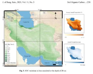
Land-use and land-use change can directly affect soil organic carbon. Improper land management can lead to carbon loss from the soil, which can greatly intensify global warming. Despite the abundance of evidence on Soil Organic Carbon (SOC) in Iran, no paper has so far compiled the data for this region. Therefore, data were collected from […]
Ecological capability assessment of a land as one of the most important steps in line with sustainable development was conducted based on identifying and pre-designed criteria, following assessment of the land’s assets and its latent power. In the present study, which was conducted in 2019, in order to reveal the changes in the region during […]
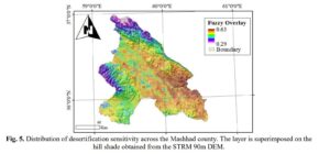
In this research, we used six MODIS remote sensing products to evaluate the vulnerability to desertification in Mashhad, Iran in 2020. The Enhanced Vegetation Index (EVI), Vegetation Condition Index (VCI), Salinity Index (SI), Synthetized Drought Index (SDI), Temperature Condition Index (TCI), and precipitation were considered in May, 2020 when vegetation growth reaches its maximum size. […]
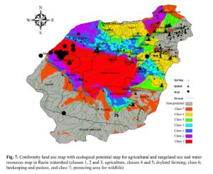
Determining the environmental capability of optimally using land and preventing the degradation of natural resources arr important steps towards a sustainable development strategy. The present study was conducted in 2014-2017 aiming to assess the ecological capability for agriculture and rangeland of the Razin watershed in Kermanshah province, west of Iran, in seven classes using the […]