The use of GIS, remote sensing, and other geographic tools in geoconservation and geotourism is increasing. These tools – hereafter referred to as ‘Geographic Information Technology’ (GIT) tools – have the potential to simplify workflow in geoconservation assessment and inventory, be employed as decision support and decision making tools for complex decisions, or be used […]
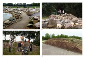
Unconsolidated diamicton deposits of Quaternary age cover much of the lowland areas of the British Isles. These are often poorly exposed and as a result their influence on development and importance as palaeontological archives are often under appreciated. Maintaining exposures in such strata is often challenging and their incorporation into the built environment is limited […]
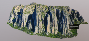
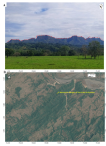
Colombia boasts extensive geodiversity thanks to complex geological processes that have shaped its landscape over geological time. The eastern region of the country is characterized by ancient rock formations, covered by a substantial layer of sediments, influenced by tectonic and erosive forces. These forces have given rise to unique geoforms that qualify as geosites. Thirteen […]
The Hondsrug UNESCO Global Geopark in the northeast of the Netherlands comprises the Hondsrug-complex, a prominent range of low till ridges created by forces of moving land ice and melt water. The unusual orientations of the ridges contrast with the usual direction of ice flow, and they are separated from each other by elongate depressions. […]