Brief description of Katla Geopark volcanism
Katla Geopark is in southern Iceland and covers the area of the three municipalities of Rangárþing eystra, Mýrdalshreppur and Skaftárhreppur (Fig. 1). The geopark is within the most volcanically active area in Iceland, where the Icelandic mantle plume and the Eastern volcanic zone (EVZ) control the activity. The EVZ is the youngest volcanic zone in Iceland and the most active one, with about 80% of the total volume of erupted material in Iceland during the last 1130 years (Thordarson and Larsen 2007). The EVZ has been active for the last 2–3 Myr and is still growing in length by 35–50 mm per year to the southwest (Thordarson and Larsen 2007; Islam and Sturkell 2017). Eight volcanic systems are on the EVZ, with six of them at least partly within the boundaries of the geopark. The six systems are Bárðarbunga, Grímsvötn, Katla, Torfajökull, Tindfjallajökull and Eyjafjallajökull, with Grímsvötn, Bárðarbunga and Katla being three of the four most active systems in Iceland in the last 1200 years (Thordarson and Larsen 2007). The six systems have created a volcanic landscape within the geopark where the main morpho-volcanic features are large ice-covered central volcanoes, long chains of hyaloclastite ridges and crater rows that have been formed during large fissure eruptions, extensive lava fields formed during effusive eruptions, large tuyas formed in submarine and or subglacial eruptions, and black sand glacial outwash plains due to glacial outburst floods linked to subglacial eruptions.
All the central volcanoes within Katla Geopark are either partially or completely covered by glaciers, which affects the eruption styles of the volcanoes. Subglacial phreatomagmatic eruptions are therefore the most common form of eruptions but are often small. They can however cause extensive and hazardous glacial outburst floods, called jökulhlaup, as meltwater from the glacier rushes down to the ocean (Thordarson and Höskuldsson 2008), and produce large amounts of tephra. Effusive eruptions also occurred from the central volcanoes in the past when there was less glacial extent during long warm periods or interglacial periods. The alternating eruption styles of the central volcanoes mean that most of them are composite volcanoes, with alternating layers of lave flow formed during interglacial periods and tuff and palagonite tuff layers from glacial periods (Thordarson and Larsen 2007).
Effusive basaltic eruptions occur mainly on the associated fissure swarms outside of the glaciated area of the volcanic systems. Effusive basaltic eruptions like these often have a short-lived explosive phase at the beginning, as lava interacts with ground water, but then turns into an effusive eruption once water is no longer able to enter the vent (Thordarson and Larsen 2007; Thordarson and Höskuldsson 2008; Németh and Kósik 2020). These basaltic fissure eruptions are usually monogenetic volcanoes and often have multiple fissures active at the same time and can build rows of cratered cones, often extending for many kilometers. Point source eruptions are also frequent on the fissure swarms, where the volcanic vent is circular or a short fissure that is reduced to a single vent. During glacial periods, the fissure swarms can be covered by ice or sea, and then ridges (tindar) and tuyas build up instead of crater rows and cones (Thordarson and Larsen, 2007; Thordarson and Höskuldsson 2008). The effusive basaltic eruptions create lava fields and the geopark is home to several of them, including the Eldgjárhraun lava field from the 939 C.E. eruption of Katla and Eldgjá, and the Eldhraun lava field from the 1783-1784 C.E. eruption of Lakagígar (often referred to as the “Laki eruption”) in the Grímsvötn volcanic system.
Katla Volcano
The Katla volcanic system consists of the central volcano Katla and an 80 km long fissure swarm that extends mainly to the north-east in the direction of the Vatnajökull glacier, but also to a lesser extent to the south-west (Larsen 2000; Thordarson et al. 2001; Schmith et al. 2018) (Fig. 1). Parts of the system are covered by the Mýrdalsjökull glacier, mainly the central volcano (Fig. 2), whereas most of the fissure swarm is ice free (Lacasse et al. 2007). The glacier is 535 km2 in area and has a volume of 140 km3. The caldera of Katla is 110 km2 and is filled in by the glacier. The thickness of the glacier is partially controlled by the depth of the caldera, as the glacier is at its thickest within the caldera where it can be up to about 750 m deep (Björnsson et al. 2000; Sigurðsson and Williams 2008). The caldera has been breached in at least three locations by erosion from the glacier and those breaches feed Kötlujökull, Entujökull and Sólheimajökull outlet glaciers which are the main outlet glaciers from the Mýrdalsjökull glacier (Sgattoni et al. 2017). Since the system is partially covered by ice, it affects the eruptions style from the system, as eruptions from within the caldera are explosive phreatomagmatic while eruptions from the fissure swarms would be effusive.
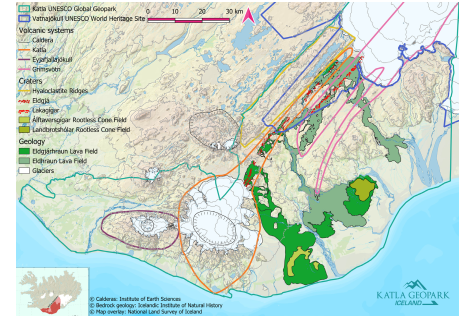
Figure 1. Map showing the boundary of Katla Geopark, the location of the volcanic systems of Eyjafjallajökull, Katla (orange line), and Grímsvötn, the crater rows of Eldgjá and Lakagígar, the area of hyaloclastite ridges, the lava fields of Eldgjárhraun and Eldhraun, and the two rootless cone fields of Álftaver and Landbrot.
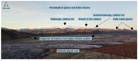
Figure 2. Mýrdalsjökull glacier in the distance with Katla volcano underneath. The Katla outlet glacier can be seen on the right-hand side, with Mýrdalssandur sand plain in front. Photo: Katla Geopark.
It is estimated that Katla has erupted over 180 times during the last 11,500 years, with most of those eruptions being of explosive basaltic type, but there have also been effusive basaltic and felsic eruptions (Óladóttir et al. 2005). Since 1500 C.E., Katla has erupted on average every 47 years (Larsen 2000), but the prehistoric eruption frequency was double that (Óladóttir et al. 2005). During the last 1200 years, Katla has erupted 21 times and only one eruption has been outside of the caldera, which was the 939 C.E. effusive eruption of Eldgjá (Larsen 2000; Thordarson et al. 2001; Larsen 2010). The other 20 eruptions were at fissures within the caldera and they were subglacial phreatomagmatic eruptions (Óladóttir et al. 2005). With 21 eruptions over the last 1200 years, Katla is the third most active system in Iceland, but is the most productive system in Iceland with about 25 km3 of erupted magma (Larsen 2000; Thordarson and Larsen 2007). The last eruption that was large enough to break through the ice was in 1918. It has been suggested that three small subglacial eruptions have occurred at Katla since then, in 1955, 1999, and in 2011 (Larsen 2000; Jakobsson and Gudmundsson 2008; Lacasse et al. 2007; Sturkell et al. 2008; Sgattoni et al. 2017). The high activity of Katla and frequent subglacial eruptions make it one of the most hazardous volcanoes in Iceland (Lacasse et al. 2007; Schmith et al. 2018). Tephra production in the subglacial eruptions is usually high and ash was able to reach Europe during the eruptions of Katla in 1625 and 1755 (Schmith et al. 2018). Tephra from Katla also has a major impact on Iceland itself (Schmith et al. 2018), and during the 1918 eruption, over half the island experienced tephra fall at some point (Larsen 2000; Steinþórsson 2012). The biggest risk from Katla is however the large jökulhlaup that accompanies the subglacial eruptions (Larsen 2000). Three known pathways for the jökulhlaup from Katla are known and they go through the three breaches in the caldera and follow the paths of the three outlet glaciers of Entujökull,
Only prehistoric jökulhlaups are known to have gone through Entujökull, the last one being dated to 822/823 C.E. (Buentgen et al. 2017), but the risk of a jökulhlaup going through Entujökull still exists. A number of jökulhlaups are believed to have gone through Sólheimajökull in the last 1200 years (Larsen 2000), with the last one being in 1999 (Sigurðsson et al. 2000). During the last 1200 years however, the jökulhlaup have normally gone through Kötlujökull outlet glacier and then flowed to sea, building up the sand plain of Mýrdalssandur (Larsen 2000). The jökulhlaup in 1918 behaved in that way (Jónsson 1982; Tómasson 1996; Jakobsson and Gudmundsson 2008), and the peak discharge has been estimated to have been between 100,000 and 300,000 m3/s (Tómasson 1996). Miraculously, nobody was killed in the flood, but it did have a profound impact on the landscape as eruptive material was deposited on the Mýrdalssandur sand plain and the coastline south-east of Katla was extended by up to 3-4 km (Jónsson 1982; Tómasson 1996; Jakobsson and Gudmundsson 2008; Sturkell et al. 2008).
Eldgjá Fissure
Eldgjá eruptive fissure is a part of the Katla volcanic system and extends from the southwest to the northeast from the central volcano (Fig. 1). It is about 75 km long and partially under the Mýrdalsjökull glacier, with discontinuous fissures and a mixed cone row (Thordarson et al. 2001; Thordarson and Larsen 2007; Sigurðardóttir et al. 2015; Oppenheimer et al. 2018). A part of Eldgjá, Eldgjá proper, is a steep-walled canyon and was often described as a volcanogenic chasm due to its morphology, but recent studies indicate that there was a pre-existing graben where the fissure opened (Miller 1989; Thordarson and Larsen 2007). The start of the eruption has often been set at or around 934 C.E. (Hammer 1984) and lately at 939 C.E. (Oppenheimer et al. 2018), but there is also the possibility that the eruption lasted for years with two major events in 934 and 939 with higher activity (Thordarson et al. 2001), with intervals of low to no volcanic activity in between (Larsen 2000, 2010). The eruption was both explosive and effusive, with the explosive phase being mostly due to phreatomagmatic activity on fissures under the glacier (Thordarson et al. 2001; Larsen 2010). The effusive phase had intense lava fountaining (Thordarson et al. 2001) and lava flowed down to the lowlands creating a vast lava field (Larsen 2000). It has been estimated that the total area of the lava flow is 844 km2 and the total volume about 20 km3 (Sigurðardóttir et al. 2015), with about 1.3 km3 of tephra erupted as well (Larsen 1990).
It is believed that the eruption had a major climatic impact, similar to that of the Lakagígar eruption in 1783–84, as about 220 Mt of SO2 were released to the atmosphere by the eruption with the potential of creating 450 Mt of H2SO4 aerosols. The lava flow also forced the abandonment of several farms in the area (Thordarson et al. 2001). Two separated fields of rootless cones were created during the eruption, Álftaversgígar and Landbrotshólar (Figs. 1, 3). The Álftaversgígar field has been eroded quite heavily since its formation, both by glacial outburst floods from Katla and wind erosion. The Landbrotshólar field is better preserved and most of the craters are completely covered by vegetation (Fig. 3).
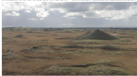
Figure 3. Part of the rootless cone field at Landbrotshólar, including a non-cratered radial cone (middle right). Photo: Katla Geopark.
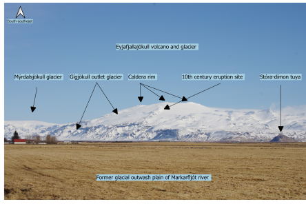
Figure 4. The northwestern side of Eyjafjallajökull glacier and volcano. The caldera rim makes up the upper part of the volcano. Parts of the western side of Katla can be seen on the left. Photo: Katla Geopark.
Rootless cone fields, or groups, can be created when lava flows over areas with water-saturated soil or surface water, such as marshes, littoral environments, lacustrine basins, riverbeds, glacial outwash plains, snow, ice, and mires (Thorarinsson 1953; Fagents and Thordarson 2007; Edwards et al. 2012; Hamilton et al. 2017). The lava is fed by lava tubes or channels, and as the lava mixes with the water or water-saturated soil, a phreatomagmatic eruption can occur (Fagents and Thordarson 2007). The eruption will break through the overlying lava if the explosions are powerful enough and the activity continues until either the lava or the water is exhausted (Fagents and Thordarson 2007; Thordarson and Höskuldsson 2008). The erupted material is tephra, ranging from fine ash to scoria to spatter, often heavily mixed with soil, which builds up a cone around the vent (Thordarson and Höskuldsson 2008; Noguchi et al. 2016; Boreham et al. 2018). The cone morphology is largely controlled by the amount of available water, the lava emplacement processes (lava channel or tube) and the amount of mixing (Fagents and Thordarson 2007; Hamilton et al. 2010). Radial symmetrical cones are built up when lava tubes feed the system, but the cone will have a V-shaped trough if formed over a channel (Hamilton et al 2010). The cones are often cratered in the middle and can range from 1 to 35 m in height, and from 2 to a few hundred meters in diameter (Fagents and Thordarson 2007; Boreham et al. 2018), where the larger cones resemble tuff rings while the smaller and steeper cones resemble cinder cones (Fagents et al. 2002).
Eyjafjallajökull Volcano
Eyjafjallajökull volcano is in the mountain range of Eyjafjöll and bears the same name as the glacier that covers parts of it. The volcano is ridge shaped (Fig. 4), being elongated in an east-west direction and the highest point of it is 1651 m above sea level., which is on the edge of the 2.5 km wide caldera of the volcano (Einarsson and Hjartardóttir 2015). The system has been active for over 700.000 years and two short fissure systems extend from the caldera, one to the west and the other to the east in the direction of Katla Volcano (Einarsson and Hjartardóttir 2015). The Eyjafjallajökull volcano is partially covered by a glacier of the same name, which is the 6th largest glacier in Iceland and covers an area about 67 km2. The thickest parts are about 200-250 m and are within the caldera. The caldera has an opening to the north, where Gígjökull outlet glacier flows out from it (Sigurðsson and Williams 2008; Gudmundsson et al. 2011; Sigurðsson 2018). Eyjafjallajökull has only four known eruptions during historical times, once during the 10th century C.E (Óskarsson 2009), then in either 1612 or 1613 C.E. (Larsen et al. 1999), in 1821–1823 C.E. (Larsen et al. 1999; Gudmundsson et al. 2010), and then famously in 2010 when it erupted and caused widespread disturbance to air traffic in Europe and across the Atlantic. The eruption in 2010 was preceded by a period of unrest, inflation, and seismic activity in 1994, 1999–2000 and in the days leading up to the eruption (Gudmundsson et al. 2011). The eruption started on the 20th of March from a single fissure at Fimmvörðuháls, with a second fissure opening a few days later. That part of the eruption was effusive (Horwell et al. 2013), with lava fountain activity that formed a small aa lava field and the two fissures formed two craters, called Magni and Móði. The activity there lasted until 12th of April when the activity shifted to a subglacial fissure that opened in the caldera of the central volcano on 14th of April. That part of the eruption was mostly explosive, as phreatomagmatic eruption began due to the interaction of meltwater from the glacier and the erupting lava, creating a high amount of tephra. During that part of the eruption there were four phases with different activity (Gudmundsson et al. 2011).
The opening phase was mostly explosive and lasted from 14th to 18th of April, when a 2 km long fissure opened below the glacier, forming four cauldrons in the ice over the eruption sites (Pistolesi et al. 2016). During this phase, the vent was covered with water, causing repeated explosions and high tephra production as the lava fragmented. The plume reached 5–10 km in height and tephra was carried to the east and south. Jökulhlaup followed the first phase, flowing to the north through Gígjökull and draining into the glacial river of Markarfljót (Guðmundsson et al. 2012b).
The second phase began on the 18th of April and lasted until 4th of May. That phase was effusive with some explosive activity, but with lower discharge rates than the first phase and the plume reached 2–4 km in height. During this phase, there was limited tephra production but about 3 km long lava flow was formed, flowing from the caldera and down through the outlet glacier Gígjökull (Guðmundsson et al. 2012b). The third phase lasted from 5th to 17th of May, where explosive activity resumed due to change in magma composition, and high tephra production started again with large amount of fine ash being produced. During this phase the plume height again rose to about 10 km and wind direction was more variable, causing higher dispersal of tephra than in the first phase (Pistolesi et al. 2016).
The fourth and final phase lasted from 18th to 22nd of May during which the eruption declined steadily and finally came to a stop. After the eruption, plumes of steam were present above the craters for months after the eruption. Most of the erupted material during the eruption was tephra, or about 80%, with most of the tephra being fine ash (Guðmundsson et al. 2012b). The tephra bulk volume produced was between 0.27–0.32 km3 with tephra thickness near the caldera exceeding 30 m but got progressively thinner further away (Guðmundsson et al. 2012b; Pistolesi et al. 2016; Möller et al. 2019). Slightly more than half of the tephra volume that was produced during the eruption settled in Iceland (Guðmundsson et al. 2012b), and the rest of the tephra was distributed over the North Atlantic, with only 5% of it reaching continental Europe (Pistolesi et al. 2016) and marks the first-time tephra from an eruption in Iceland has been able to reach Europe since Mt. Hekla eruption in 1947 (Guðmundsson et al. 2012b).
Grímsvötn and Lakagígar
Grímsvötn volcanic system (Fig. 1) is the most active system in Iceland during historical times (Gudmundsson et al. 2012a; Horwell et al. 2013) and is believed to be directly above the mantle plume (Bindeman et al. 2006). Most of the system is covered by Vatnajökull glacier, but about 30 km of the associated fissure swarm, stretching to the SW, is ice free (Thordarson and Larsen 2007). The Laki fissure swarm is the associated fissure swarm with Grímsvötn (Björnsson and Einarsson 1990) and is best known for the eruption of Lakagígar (i.e., Laki craters) in 1783–84 C.E. The central volcano of Grímsvötn has a 62 km2 and 200-300 m deep caldera which is covered with 50–250 m thick ice (Thordarson and Larsen 2007; Björnsson and Einarsson 1990). There is an extensive geothermal system in the caldera and a subglacial lake as well that is contained by an ice dam on the caldera rim (Björnsson and Einarsson 1990). The ice dam breaks periodically and the caldera is drained, causing jökulhlaup in the glacial river of Skaftá. (Björnsson and Einarsson 1990). There have been 64 confirmed eruptions from the system during historical times, with most of them coming from the caldera (Thordarson and Larsen 2007). Eruptions from the system are usually explosive basaltic eruption, when the eruption site is underneath the glacier, but effusive basaltic eruptions occur on the ice-free part of the fissure swarm. The subglacial eruptions in the system tend to be small, or about 0.01–0.1 km3 of erupted material, and tephra is often not transported outside of the Vatnajökull glacier area (Bindeman et al. 2006; Jakobsson and Gudmundsson 2008; Horwell et al. 2013). The eruptions normally cause only minor damage to the glacier, as the melt is limited to about 0.1 km3 of ice, creating a few hundred-meter-wide openings into the glacier above the eruption site (Jakobsson and Gudmundsson 2008). Jökulhlaup are normally caused by the eruptions and are often larger than the jökulhlaup caused by the geothermal system (Björnsson and Einarsson 1990). The peak discharge of these jökulhlaup is about 40.000 m3/s (Thordarson and Larsen 2007) and they can cause significant property damage to roads, bridges, and agricultural land.
The last eruption of Grímsvötn central volcano was in 2011, from 21st to 28th of May. It was a subglacial eruption with explosive activity and tephra production, with the eruption plume reaching up to 20 km in height. Although this eruption was short-lived, it was much larger than the 2010 eruption of Eyjafjallajökull, as Grímsvötn released more tephra on the first day than during the entire eruption of Eyjafjallajökull and produced up to two or three times the bulk volume of tephra. During and after the eruption, tephra fell in the British Isles and Norway, with minor disruption to air traffic. The reasons why it did not cause as much disruption to air traffic as Eyjafjallajökull in 2010 are that it had a shorter eruption period and strong winds in the upper troposphere and stratosphere were not present as in 2010, preventing large scale dispersal (Gudmundsson et al. 2012a; Gudmundsson et al. 2012b).
The most famous eruption from the system was however the 1783–1784 eruption of Laki fissure swarm, The Lakagígar eruption. The Lakagígar and Eldgjá eruptions are two of the largest volcanic events in Iceland’s history and the largest of its kind on the planet in the last couple of thousand years (Thordarson and Larsen 2007). The Lakagígar eruption started on 8th of June 1783 and created a 27 km long SW to NE trending fissure that extended to the central volcano of Grímsvötn. The fissure consists of ten en echelon fissures created in ten eruption episodes that had more than 140 vents (Thordarson and Self 1993; Thordarson et al. 1996, 2003). The eruption episodes at each fissure started with an earthquake swarm, followed by an explosive eruption that changed to effusive eruption in the following days once groundwater stopped interacting with the magma (Thordarson et al. 2003). Four eruption episodes also occurred at Grímsvötn volcano which were all explosive (Thordarson et al. 2003). The fissures created a mixed cone row, with numerous scoria and spatter cones along with two tuff cones (Thordarson et al. 2003) (Fig. 5). Some 14.7 km3 of lava has erupted during the eruption, and 0.4 km3 tephra (Thordarson and Self 1993), creating a 600 km2 lava field called Eldhraun (Figs. 1, 6). The lava field is defined as rubbly pahoehoe lava (Guilbaud et al. 2005), which is now mostly covered with woolly fringe moss, and partially covered by the lava field created in the Eldgjá eruption. The eruption released about 122 Mt of SO2 into the atmosphere, creating 200 Mt of H2SO4 aerosols, and caused major climatic impact on Iceland and the northern hemisphere. The aerosols were largely removed from the atmosphere as acid precipitation that caused volcanic pollution that caused the death of thousands (Thordarson and Self 1993, 2003). The impact of the eruption in Iceland was severe, as 50% of cattle, 79% of sheep and 76% of horses died due to the eruption, causing a famine that led to the death of about 23.6% of the population in Iceland. The lava also covered two churches and 14 farms, with 30 other farms having large portion of their farmlands destroyed, and two parishes were uninhabitable for two years (Thórarinsson 1968).
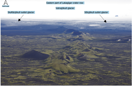
Figure 5. Photo of the eastern part of Lakagígar crater row and the edge of Vatnajökull glacier in the distance. Photo: Katla Geopark.
Hyaloclastite Ridges
One of the most remarkable volcanic formations within Katla Geopark, and a unique geoheritage in the world, are the three long mountain ranges of Kattarhryggir, Grænifjallgarður and Fögrufjöll (Figs. 1, 7). These three mountain ranges are hyaloclastite ridges and believed to be the subglacial equivalent of large fissure eruptions such as the Eldgjá and Lakagígar eruptions (Jakobsson and Guðmundsson 2012). The hyaloclastites are formed by non-explosive granulation and explosive fragmentation of magma due to magma-water interaction. The grain size of the hyaloclastites can vary from very fine-grained ash to larger rock fragments (Fisher and Schmincke 1984; Werner and Schmincke 1999). The ridges all have a NE-SW direction and can be up to 44 km long. The bottom of the ridges is often made from pillow lava, with hyaloclastite forming the largest part of the ridges and sometimes lava can flow on the top of them if the eruption breaks through the glacier. The length of the ridges is normally more than double their width and tend to have rows of peaks at a semi-even interval (Jakobsson and Guðmundsson 2012).
Geotourism
The geotourism potential of these morpho-volcanic formations is high and all the sites are geosites within Katla Geopark. Each location has an information panel where people can read about the geology and the history of each site. This information, especially the geology as most people do not know much about these types of formations, is very important to educate visitors so they can fully enjoy what they are seeing. The location of Lakagígar, Eldgjá and the hyaloclastite ridges prevents year-round geotourism though, as the areas close during the wintertime due to snow, wet grounds, and impassable terrain. Katla and Eyjafjallajökull volcanoes also pose a challenge as the terrain is difficult to traverse and the sheer size of the mountains makes any hike difficult. There are however several viewpoints for each volcano, often at other geosites, with information boards where people can read about the volcanic activity and the formations formed by them.
The lava fields and the rootless cones fields are however much more accessible and there is all-year tourism there with easily accessible locations and information signs. Tourism has been growing rapidly in Iceland over the last decade or so and in 2017, 2.2 million tourists visited Iceland (Óladóttir 2018). The majority of tourists that visit Iceland also visit south Iceland, and in 2022 the ratio was just over 80% (Óladóttir 2022). Most tourists come to Iceland with the idea of seeing nature and unique natural sites (Óladóttir 2018), with numerous popular sites within Katla Geopark such as Seljalandsfoss and Skógafoss waterfalls, Sólheimajökull outlet glacier and Fjaðrárgljúfur canyon. Even though these sites are not volcanic in origin, they are closely linked to volcanism and are all connected one way or the other with one or more of the Katla, Eldgjá, Eyjafjallajökull, Lakagígar craters and the hyaloclastite ridges.
These attractive geosites are also among the most heavily researched and monitored areas in Iceland, both by national and international scientists. The main focus on monitoring are the two volcanic systems of Katla and Grímsvötn, due to frequent subglacial eruptions and dangerous jökulhlaup from the two systems, and they are monitored with seismic sensors and GPS monitoring for crustal movements. The glacial rivers are also monitored to give an early warning of glacial outburst floods and the chemical composition of the water can give an indication about a possible subglacial eruption (Elefsen et al. 2002). Research on the petrology, morphology and formation/eruption history of these sites is also frequent, but the main focus today lies in researching new events. For example, the 2010 eruption of Eyjafjallajökull is probably the most heavily studied eruption in Iceland’s history and the 2011 eruption of Grímsvötn and the small subglacial eruption of Katla in the same year have been researched heavily as well.
Conservation
When Katla Geopark was planned in 2009–2010 it was not based on any existing structure. The Lakagígar craters of the proposed geopark were already part of Vatnajökull National Park and in 2011, a year after Katla Geopark was established, the National Park was extended to include the hyaloclastite ridges of Grænufjöll, Fögrufjöll and Kattarhryggir, and Langisjór lake, already within the geopark (Ríkisútvarpið 2011).
Geoparks did not have any special role in Icelandic legislation and do not to this day. The notion of Katla Geopark was developed by the newly established University Centre of South Iceland through a regionally funded pilot project on how to counteract the continuous depopulation of the area (Háskólafélag Suðurlands 2011). The idea was to use the volcanic landscape and features as an asset to develop geotourism. The municipalities turned out to be favorable to this idea, not necessarily for geo-conservation as such, but as a tool in regional development. It has remained a continuous challenge for these sparsely populated rural areas of about 3000 people in an area of more than 9,500 km2 to keep the geopark up and running, especially since there was no existing structure in place before.
Katla´s application to join the European and Global Geoparks Network was accepted at the 10th European Geoparks Conference held in Gea Norvegica Geopark in Langesund in Norway in 2011. Following the adoption of the UNESCO Global Geoparks designation list at the 38th UNESCO General Conference in Paris in 2015, Katla Geopark acquired the status of a UNESCO Global Geopark (Háskólafélag Suðurlands 2011; UNESCO 2023).
In Iceland, protected areas are registered in the Nature Conservation Act No. 60/2013 and the natural conservation register (Lög um náttúruvernd nr. 60 2013). Nature reserves may be established in areas considered important for their landscape, flora, or fauna. Common to all the nature reserves is protection of their wildlife and landscape and this can involve a restriction on development and public access. The degree of restriction may vary. Natural monuments are natural phenomena that are unique, of outstanding beauty or scientific interest. These include waterfalls, volcanoes, hot springs, rock pillars, fossils, and minerals. The Minister for the Environment and Natural Resources publishes a new Natural Conservation Register every five years, as per Article 13 of the Nature Conservation Act No. 60/2013 (Lög um náttúruvernd nr. 60 2013). Park Rangers from the Environment Agency of Iceland and Vatnajökull National Park monitor legally protected sites and other vulnerable sites in the area such as Fjaðrárgljúfur, Hjörleifshöfði, Eldhraun and larger area around Skógafoss waterfall. Areas are sometimes closed off to protect vegetation from damage and during nesting seasons of birds. Volunteers often maintain paths and other infrastructure, but otherwise governmental maintenance grants are used for monitoring and maintenance.
In 2017, Katla Geopark obtained a 5-year contract total funding of 104,000,000 Icelandic Króna (874,045 EUR in 2017) with the Ministry of Environment and Natural Resources, to support the geopark operations with emphasis on the conservation of natural and cultural heritage (Mbl 2016). A committee was established with members from the Iceland Environment Agency, Cultural Heritage Agency and Vatnajökull National Park and UNESCO World Heritage Site, along with a specialist from the ministry, and this committee was chaired by the geopark Manager of Katla Geopark (Stjórnarráð Íslands 2017). The committee’s role was to ensure cooperation on co-governance and management of the area, involving all relevant stakeholders and the approval of an Action Plan, updated annually with key actions and actors.
Katla Geopark has 81 geosites, around half of them legally protected and managed by governmental institutions including Vatnajökull National Park, the Environmental Agency of Iceland, and the Cultural Heritage Agency of Iceland. The remaining half are in planning responsibility of the municipalities, and some receive protection through municipal master plans. In 2019, about 2100 km2 of the area of the geopark which is shared area with Vatnajökull National Park, became designated as a UNESCO World Heritage Site (UNESCO 2019) when the entire National Park became a UNESCO World Heritage Site. The shared area receives legal protection through Vatnajökull National Park. In 2018, Katla Geopark published its first Destination Management Plan, in cooperation with NOHNIK Landscape and Architecture, and the work involved all relevant stakeholders of the geopark (NOHNIK 2017). This plan is now part of municipal master plans of the area, ensuring that Katla Geopark is part of the region´s development and future planning strategies. Even though these solutions can support conservation measures in many ways with active cooperation of those involved, they are not without their limitations. The Destination Management Plan is not legally binding and cannot ensure that sites are properly managed nor protected unless they are part of the Nature Conservation Act No 60 /2013 or enlisted on The Natural Conservation Register. However, as of June 16, 2020, the manager of Katla Geopark is a substitute member of the Advisory Committee to the Minister of Environmental and Natural Resources for the Natural Conservation Register (Samband íslenskra sveitarfélaga 2020). Having a legally binding plan, that succeeds the authority of the municipal master plans, would support conservation efforts and legal protection of sites.
References
Bindeman IN, Sigmarsson O & Eiler J (2006). Time constraints on the origin of large volume basalts derived from O-isotope and trace element mineral zoning and U-series disequilibria in the Laki and Grímsvötn volcanic system. Earth and Planetary Science Letters. 245: 245-259. https://doi.org/10.1016/j.epsl.2006.02.029
Björnsson H and Einarsson P (1990). Volcanoes beneath Vatnajökull, Iceland. Jökull. 40: 147-168. http://dx.doi.org/10.33799/jokull1990.40.147
Björnsson H, Pálsson F & Guðmundsson MT (2000). Surface and bedrock topography of the Mýrdalsjökull ice cap, Iceland: The Katla caldera, eruption sites and routes of jökulhlaups. Jökull. 49:29-46. http://dx.doi.org/10.33799/jokull2000.49.029
Boreham F, Cashman K, Rust A & Höskuldsson Á (2018). Linking lava flow morphology, water availability and rootless cone formation on the Younger Laxá Lava, NE Iceland. Journal of Volcanology and Geothermal Research. 364: 1-19. https://doi.org/10.1130/G39269.1
Buentgen U, Eggertsson Ó, Wacker L, et al. (2017). Multi-proxy dating of Iceland’s major pre-settlement Katla eruption to 822-823 CE. Geology. 45: 783-786. https://doi.org/10.1130/G39269.1
Edwards B, Magnússon E, Thordarson T, et al. (2012). Interactions between lava and snow/ice during the 2010 Fimmvörðuháls eruption, south-central Iceland. Journal of Geophysical Research. 117( B4): 302. https://doi.org/10.1029/2011JB008985
Einarsson P and Hjartardóttir ÁR (2015). Structure and tectonic position of the Eyjafjallajökull volcano, S-Iceland. Jökull. 65: 1-16. http://dx.doi.org/10.33799/jokull2015.65.001
Elefsen SÓ, Snorrason Á, Haraldsson H, Gíslason SR& Kristmannsdóttir H (2002). Real-time monitoring of glacial rivers in Iceland. The Extremes of the Extremes: Extraordinary Floods. Proceedings of a symposium held at Reykjavik, Iceland. July 2000.. IAHS Publ.
Fagents SA, Lanagan P & Greeley R (2002). Rootless cones on Mars: a consequence of lava-ground ice interaction. Volcano–Ice Interaction on Earth and Mars. Geological Society, London, Special Publications. http://dx.doi.org/10.1144/GSL.SP.2002.202.01.15
Fagents SA & Thordarson T (2007). Rootless volcanic cones in Iceland and on Mars. The Geology of Mars. Cambridge University Press, Cambridge.
Fisher RV and Schmincke H-U (1984). Pyroclastic rocks. Springer Verlag, Berlin.
Gudmundsson M, Pedersen R, Vogfjörd K, Thorbjarnardóttir B, Jakobsdóttir S & Roberts M (2010). Eruptions of Eyjafjallajökull volcano, Iceland. Eos, Transactions American Geophysical Union. 91: 190–191. https://doi.org/10.1029/2010EO210002
Gudmundsson S, Björnsson H, Magnússon E, Berthier E, Pálsson F, Gudmundsson MT, Högnadóttir T & Dall J (2011). Response of Eyjafjallajökull, Torfajökull and Tindfjallajökull ice caps in Iceland to regional warming, deduced by remote sensing. Polar Research. 30. https://doi.org/10.3402/polar.v30i0.7282
Gudmundsson MT, Höskuldsson Á, Larsen G, et al. (2012a). The May 2011 eruption of Grímsvötn. EGU General Assembly. Geophysical Research Abstracts ( vol. 14. pp. EGU2012-12119), Vienna.
Gudmundsson MT, Thordarson T, Höskuldsson Á, et al. (2012b). Ash generation and distribution from the April-May 2010 eruption of Eyjafjallajökull, Iceland. Scientific Reports. 2: 572. https://doi.org/10.1038/srep00572
Guilbaud MN, Self S, Thordarson T & Blake S (2005). Morphology, surface structures, and emplacement of lavas produced by Laki, A.D. 1783–1784. Geological Society of America Special Paper. 396: 81–102. http://dx.doi.org/10.1130/0-8137-2396-5.81
Hamilton CW, Thordarson T, Fagents SA (2010). Explosive lava–water interactions I: architecture and emplacement chronology of volcanic rootless cone groups in the 1783–1784 Laki lava flow, Iceland. Bulletin of Volcanology. 72: 449–467. http://dx.doi.org/10.1007/s00445-009-0330-6
Hamilton CW, Fitch EP, Fagents SA & Thordarson Th (2017). Rootless tephra stratigraphy and emplacement processes. Bulletin of Volcanology. 79: 11. http://dx.doi.org/10.1007/s00445-016-1086-4
Hammer CU (1984). Traces of Icelandic eruptions in the Greenland ice sheet. Jökull. 34:51–65.
Háskólafélag Suðurlands (2011) Til hamingju! – Katla jarðvangur. https://hfsu.is/til-hamingju-katla-jardvangur/. Retrieved March 7, 2023.
Horwell CJ, Baxter PJ, Hillman SE, et al. (2013). Physiochemical and toxicological profiling of ash from the 2010 and 2011 eruptions of Eyjafjallajökull and Grímsvötn volcanoes, Iceland. Environmental Research. 127: 63-73. https://doi.org/10.1016/j.envres.2013.08.011
Islam MT and Sturkell E (2017). Rheological responses to plate boundary deformation at the Eastern Volcanic Zone in Iceland. Tectonophysics. 717: 16-26. https://doi.org/10.1016/j.tecto.2017.06.027
Jakobsson SP and Guðmundsson MT (2012). Móbergsmyndunin og gos undir jöklum. Náttúrufræðingurinn. 82: 113-125
Jakobsson SP and Gudmundsson MT (2008). Subglacial and intraglacial volcanic formations in Iceland. Jökull. 58: 179-196. http://dx.doi.org/10.33799/jokull2008.58.179
Jónsson J (1982). Notes on the Katla volcanoglacial Debris Flows. Jökull. 32: 61-68.
Lacasse C, Sigurdsson H, Carey SN, Jóhannesson H, Thomas LE & Rogers NW (2007). Bimodal volcanism at the Katla subglacial caldera, Iceland: insight into the geochemistry and petrogenesis of rhyolitic magmas. Bulletin of Volcanology. 69: 373-399: https://doi.org/10.1007/s00445-006-0082-5
Larsen G (2010). Katla: Tephrochronology and eruption history. Developments in Quaternary Sciences . 13: 23–49. https://doi.org/10.1016/S1571-0866(09)01303-7
Larsen G (2000). Holocene eruptions within the Katla volcanic system, south Iceland: Characteristics and environmental impact. Jökull. 49: 1–28. http://dx.doi.org/10.33799/jokull2000.49.001
Larsen G, Dugmore A & Newton A (1999). Geochemistry of historical-age silicic tephras in Iceland. The Holocene. 9(4): 463–471. https://doi.org/10.1191/095968399669624108
Larsen G (1990). The 10th century Eldgjá-Katla eruption: its products and consequences, preliminary results. Geonytt. 17: 70-71.
Lög um náttúruvernd nr. 60 (2013). https://www.althingi.is/lagas/nuna/2013060.html. Retrieved March 3, 2023.
Mbl (2016). Fimm ára stuðningur við Kötlu jarðvang. https://www.mbl.is/frettir/innlent/2016/10/21/fimm_ara_studningur_vid_kotlu_jardvang/. Retrieved March 5, 2023.
Miller DJ (1989). The 10th century eruption of Eldgjá, southern Iceland. Research Report 8903. Nordic Volcanological Institute, University of Iceland, Reykjavík.
Möller R, Dagsson-Waldhauserova P, Möller M, Kukla PA, Schneider C & Gudmundsson MT (2019). Persistent albedo reduction on southern Icelandic glaciers due to ashfall from the 2010 Eyjafjallajökull eruption. Remote Sensing of Environment. 23: 111396. https://doi.org/10.1016/j.rse.2019.111396
Németh K and Kósik S (2020). Review of explosive hydrovolcanism. Geosciences. 10: 44; doi:10.3390/geosciences10020044 .
Noguchi R, Höskuldsson Á & Kurita K (2016). Detailed topography, distributional, and material analyses of rootless cones in Mývatn, Iceland. Journal of Volcanology and Geothermal Research. 318: 89-102. https://doi.org/10.1016/j.jvolgeores.2016.03.020
NOHNIK (2017). Destination Management Plan, Katla UNESCO Global Geopark. https://www.katlageopark.com/media/81660/DMP-Katla-magazine-LQ.pdf. Retrieved March 3, 2023.
Oppenheimer C, Orchard A, Stoffel M, et al. (2018). The Eldgjá eruption: timing, long-range impacts and influence on the Christianisation of Iceland. Climatic Change 147: 369–381. https://doi.org/10.1007/s10584-018-2171-9
Óladóttir BR, Larsen G, Þórðarson Þ & Sigmarsson O (2005). The Katla volcano S-Iceland: Holocene tephra stratigraphy and eruption frequency. Jökull. 55: 53-72. http://dx.doi.org/10.33799/jokull2005.55.053
Óladóttir OÞ (2018). Ferðaþjónusta á Íslandi í tölum. Reykjavík: Ferðamálastofa. https://www.ferdamalastofa.is/static/files/ferdamalastofa/talnaefni/ferdatjonusta-i-tolum/ferdathjonusta-i-tolum-2018.pdf. Retrieved March 8, 2023.
Óladóttir OÞ (2022). Ferðaþjónusta í tölum – sumar 2022. Reykjavík: Ferðamálastofa. https://www.ferdamalastofa.is/static/files/ferdamalastofa/talnaefni/ferdatjonusta-i-tolum/2022/sumar-2022-isl.pdf. Retrieved March 8, 2023.
Óskarsson BV (2009). The Skerin Ridge on Eyjafjallajökull, South Iceland: Morphology and Magma-Ice Interaction in an Ice-confined Silicic Fissure Eruption. Master’s Thesis. Faculty of Earth Sciences, University of Iceland. Available at: http://hdl. handle.net/1946/4375.
Pistolesi M, Cioni R, Francalanci L, Bertagnini A, D'Oriano C, Braschi E & Höskuldsson A (2016). The onset of an eruption: selective assimilation of hydrothermal minerals during pre-eruptive magma ascent of the 2010 summit eruption of Eyjafjallajökull volcano, Iceland, Journal of Volcanology and Geothermal Research. 327: 449-458. https://doi.org/10.1016/j.jvolgeores.2016.09.011
Ríkisútvarpið (2011). Stækka Vatnajökulsþjóðgarð. https://www.ruv.is/frettir/innlent/staekka-vatnajokulsthjodgard. Retrieved March 7, 2023.
Samband íslenskra sveitarfélaga (2020). Fundargerð 866. fundar. https://www.ssne.is/static/files/Fundargerdir/13/stjorn-sambands-islenskra-sveitarfelaga-886.pdf. Retrieved March 7, 2023.
Schmith J, Höskuldsson Á, Holm PM & Larsen G (2018). Large explosive basaltic eruptions at Katla volcano, Iceland: Fragmentation, grain size and eruption dynamics. Journal of Volcanology and Geothermal Research. 354: 140-152. https://doi.org/10.1016/j.jvolgeores.2017.03.028
Sgattoni G, Gudmundsson Ó, Einarsson P, Lucchi F, Sadeghistorkhani K, Roberts R & Tryggvason A (2017). The 2011 unrest at Katla volcano: Characterization and interpretation of the tremor sources. Journal of Volcanology and Geothermal Research. 338: 63-78. http://dx.doi.org/10.1016/j.jvolgeores.2017.03.028
Sigurðardóttir SS, Gudmundsson MT & Hreinsdóttir S (2015). Mapping of the Eldgjá lava flow on Mýrdalssandur with magnetic surveying. Jökull. 65: 61-71. http://dx.doi.org/10.33799/jokull2015.65.061
Sigurðsson O (2018). Hversu hratt bráðna jöklar á Íslandi? Vísindavefurinn, 30. maí 2018. http://visindavefur.is/svar.php?id=70098. Retrieved July 21, 2019.
Sigurðsson O and Williams Jr RS (2008). Geographic names of Iceland’s glaciers: Historic and modern. U.S. Geological Survey Professional Paper 1746. https://pubs.usgs.gov/pp/1746/
Sigurðsson O, Zóphóníasson S & Ísleifsson E (2000). Jökulhlaup úr Sólheimajökli 18. júlí 1999. Jökull. 49: 75-80. http://dx.doi.org/10.33799/jokull2000.49.075o
Steinþórsson S (2012). Hvað getur þú sagt mér um Kötlugosið 1918? Vísindavefurinn, 19. mars 2012. http://visindavefur.is/svar.php?id=61203. Retrieved October 18, 2019.
Sturkell E, Einarsson P, Roberts MJ, Geirsson H, Gudmundsson MT, Sigmundsson F, Pinel V, Gudmundsson GB, Ólafsson H & Stefánsson R (2008). Seismic and geodetic insights into magma accumulation at Katla subglacial volcano, Iceland: 1999 to 2005. Journal of Geophysical Research. 113, https://doi.org/10.1029/2006JB004851
Thórarinsson S (1968). Skaftáreldar og Lakagígar. Náttúrufræðingurinn. 37: 27-57
Thorarinsson S (1953). The crater groups in Iceland. Bulletin of Volcanology. 2: 1-44. https://doi.org/10.1007/BF02596003
Thordarson Th and Höskuldsson Á (2008). Postglacial volcanism in Iceland. Jökull. 58: 197-228. http://dx.doi.org/10.33799/jokull2008.58.197
Thordarson Th and Larsen G (2007). Volcanism in Iceland in historical times: volcano types, eruption styles and eruptive history. Journal of Geodynamics. 43: 118-152. https://doi.org/10.1016/j.jog.2006.09.005
Thordarson Th and Self S (1993). The Laki (Skaftár Fires) and Grímsvötn eruptions in 1783–1785: Bulletin of Volcanology. 55: 233–263. doi:10.1007/BF00624353
Thordarson Th and Self S (2003). Atmospheric and environmental effects of the 1783-1784 Laki eruption: a review and reassessment. Journal of Geophysical Research. 108: 1-29. https://doi.org/10.1029/2001JD002042
Thordarson Th, Larsen G, Steinthorsson S & Self S (2003), The 1783-1785 A.D. Laki-Grímsvötn eruptions II: Appraisal based on contemporary accounts: Jökull. 53: 11–48. http://dx.doi.org/10.33799/jokull2003.53.011
Thordarson Th, Miller DJ, Larsen G, Self S & Sigurdsson H (2001). New estimates of sulfur degassing and atmospheric mass-loading by the 934 AD Eldgjá eruption, Iceland. Journal of Volcanology and Geothermal Research. 108, 33-54. https://doi.org/10.1016/S0377-0273(00)00277-8
Thordarson Th, Self S, Óskarsson N & Hulsebosch R (1996). Sulfur, chlorine and fluorine degassing and atmospheric loading by the 1783-1784 A.D. Laki (Skaftar Fires) eruption in Iceland: Bulletin of Volcanology. 58: 205–225. https://doi.org/10.1007/s004450050136
Tómasson H (1996). The Jökulhlaup from Katla in 1918. Annals of Glaciology. 22: 249–254. https://doi.org/10.3189/1996AoG22-1-249-254
UNESCO (2023). Katla UNESCO Global Geopark (Iceland). https://en.unesco.org/global-geoparks/katla. Retrieved March 7, 2023.
UNESCO (2019). Vatnajökull National Park – Dynamic Nature of Fire and Ice. https://whc.unesco.org/en/list/1604. Retrieved May 3, 2023.
Werner R and Schmincke H-U (1999). Englacial vs lacustrine origin of volcanic table mountains: evidence from Iceland. Bulletin of Volcanology. 60: 335–354. https://doi.org/10.1007/s004450050237