Introduction
The Ipolytarnóc Fossils Nature Conservation Area (IFNCA) is one of the main gateways and scientific centers of the Slovak-Hungarian transborder Novohrad–Nógrád UNESCO Global Geopark (N-N UGGp). Within its 510 hectares, it contains fossiliferous strata of lower Miocene (23–17 Myr old) marine and terrestrial sediments, which yielded both high numbers and high quality of fossils (shark teeth, petrified trees, leaf impressions and ichnofossils), representing both conservation and concentration Lagerstätten categories (Tardy et al. 2004; Szarvas 2007).
A volcanic catastrophe destroyed and conserved these paleohabitats 17 Myr ago, which is why it was named the “Prehistoric Pompeii” by Othenio Abel. The first documented excavation, in 1836, was a huge petrified tree. The site has been protected by the State since 1944 and managed by the Bükk National Park Directorate (BNPD). Within its inner core, at the lower Miocene stratotype section in the Borókás Ravine, a geological study trail was established in 1985, which has become one of the most visited and developed geotouristic destinations in Hungary. New finds from ongoing excavations are interpreted by high-tech methods. Some ex-situ, 7 Myr old Bükkábrány trees, rescued from a nearby lignite opencast mine, are preserved at Ipolytarnóc Fossils.
Location and Geological Setting
The site is situated in the northern Hungarian part of the Carpathian Basin, in Nógrád county. It is bordered by the urban area of Ipolytarnóc settlement and the state border between Hungary and Slovakia (Fig. 1). It is the northernmost protected area on the Hungarian side of the N-N UGGp (48º14’12” N; 19º39’25” E).
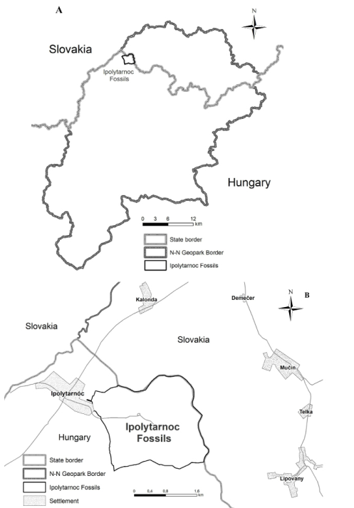
Figure 1. Position of the Ipolytarnoc Fossils Nature Conservation Area. A) within the Slovak-Hungarian transnational Novohrad-Nógrád UNESCO Global Geopark and B) at the vicinity of the state border, situated east of the Ipolytarnoc settlement on the Hungarian side.
Ipolytarnóc and the Nógrád Basin lie on the inner side of the Western Carpathian arch, near the northern margin of the Pannonian Basin. The sedimentary basin evolution of the North Pannonian Basin is linked with the history of Central Paratethys and controlled by the interplay of eustasy and regional tectonics. The basal rocks of the Ipolytarnóc area are poorly investigated Paleozoic metamorphic phyllite, gneiss and amphibolite. The oldest sediment covering the Paleozoic is located ca. 600 m below the present surface, containing Eocene limestone and traces of terrestrial deposits. Lower Miocene rocks exposed on the surface dominate the inner core of the site (Fig. 2).
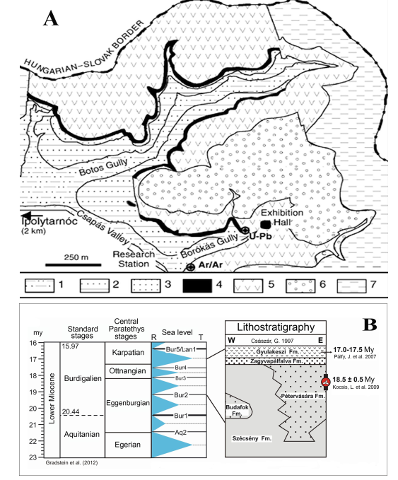
Figure 2. Geological setting of the Ipolytarnoc Fossils. A) surface geologic map of the inner core (after Bartkó 1985; Palfy 2007). 1, Szécsény Schlier Formation; 2, Pétervására Sandstone Formation; 3, pebble, conglomerate (Zagyvapálfalva Formation); 4, Track-bearing sandstone (Zagyvapálfalva Formation); 5, Gyulakeszi Rhyolite Tuff Formation; 6, Redeposited tuff and sandstone (Salgótarján Browncoal Formation); 7, Variegated clay (Salgótarján Browncoal Formation). B) Stratigraphic position of the Lower Miocene formations (after Hamor 1985; Kocsis 2016). L, Langhian; T, transgression; R, regression.
The 300–400 m thick late Oligocene–early Miocene marine Szécsény Schlier and the tidal Pétervására formations probably developed at the same time in different environments. The latter is famous in Ipolytarnóc and surroundings because it yields large numbers of shark teeth, sporadic marine reptile and mammal finds, molluscs and foraminifers.
The marine beds were first reported by Koch (1903, 1904). He described 25 shark species in eight genera, with four new species among them. After his description, the “Ipolytarnóc shark tooth-bearing bed” became a characteristic marker of the Eggenburgian stage of the lower Miocene in Central Paratethys. The original fauna was revised recently based on new finds (Kocsis 2007, 2016), showing a diverse lower Miocene shark community (19 genera and 16 certain species), from warm-temperate waters in a subtropical climate with wide occupation range.
The terrestrial-fluviatile Zagyvapálfalva Formation is a ca. 5 m thick gravel and sand channel deposit. The uppermost part of this Formation is named the “Ipolytarnóc footprint sandstone”, and it contains petrified tree trunks, plant impressions and footprints.
Plant fossils
The 42 m long part of a giant petrified tree trunk (Pinuxylon tarnocziense, relative of sugar pines), that bridged a stream in the Borókás Ravine was exposed at the beginning of the 19th century (Fig. 3). Its discovery initiated scientific research at the site in 1836, led by Kubinyi (1842, 1853).

Figure 3. The giant petrified tree, which find instigated the research of the site. A) A drawing by Markó, K. the elder, cc. 1840 (In: Kubinyi, F. & Vahot, I. 1854). B) In situ fragments of it within the protective cellar built around 1866.
A whole forest was destroyed by volcanism, and the trees were toppled on top of the paleosurface by the nearby volcanic blast. Most of the tree remains were embedded at the sandstone-tuff transition, under the plinian ash-fall unit. A detailed analysis of the petrified tree trunks revealed that the 17–18 Ma rainforest comprised at least seven conifer, four deciduous and one palm species.
Paleobotanical studies identified 64 fossil leaf taxa among the large collection of macrofloral remains, based on samples of nearly 15 thousand leaves (Hably 1985). The “Florenkomplex Ipolytarnóc” was dominated by laurophyllous taxa, including numerous species of magnolias, laurels, ancient avocados, and later extinct walnuts.
Geological Setting of the Fossil Tracks
The footprint-bearing sandstone is covered by 50–60 m of volcanic rocks, mostly rhyolite tuffs (Gyulakeszi Rhyolite Tuff Formation). Overlying these are re-deposited rhyolite tuffs, terrestrial mud, quartzite conglomerate and brown coal layers (Salgótarján Browncoal Formation), and younger sediments were later eroded. The present surface shows only Quaternary soil formations.
The late László Korpás presented one geological-geomorphological interpretation of the lower Miocene history of Ipolytarnóc in an unpublished report (Korpás 2003). He argued that the Pétervására Sandstone containing the footprint layers was deposited in a shallow marine bay. The tidal environment produced a combination of underwater dunes, delta fronts and spits at the stream mouth. According to Korpás, the width of the former river was 35 m, and the banks had 40–50 m wide bars. During high energy water transport, the riverbed divided the former delta deposits into two areas 200 m long, and a strong wind then shaped these parts into transverse shore dunes.
On the other hand, Kordos (1985) and Kordos and Mészáros (2018) argued that the alternating thick and thin lamination of the “Ipolytarnóc Sandstone” with a wide range of microrelief forms (ripple marks, water abrasion surfaces, deep soft and consolidated mud) was produced by daily tidal events and seasonal rainwater oscillations. Among the sandstone layers, swampy and paleosol deposits intercalated with plant remains. Consequently, the Ipolytarnóc animal tracks were conserved by the oscillation of different fluvial events, and they were protected from erosion by the rhyolite volcanism. The term “Prehistoric Pompeii” refers to the fact that the underlying sediments were preserved by this rhyolite cover, but this was not the main reason that the tracks survived.
After a long debate, the stratigraphical position of the formations was decided as lower Miocene (Eggenburgian), and the Gyulakeszi Rhyolite Tuff Formation marks the boundary between the lower Miocene Eggenburgian and Ottnangian stages. The Salgótarján Browncoal Formation was deposited during the Ottnangian (lower Miocene).
The age of the Gyulakeszi Rhyolite Tuff complex was first investigated using K/Ar dating at Ipolytarnóc, giving an average was 19.6 ± 1.4 Myr. Then, 40Ar/39Ar single-crystal measurements gave an age between 17.02 and 16.99 Ma. Later, the rhyolite tuff samples from Ipolytarnóc single-crystal zircon U-Pb examination gave an age of 17.41 Ma. According to these new radiometric and paleomagnetic investigations, the age of the footprints at Ipolytarnóc is ca. 18–17 Ma instead of ca. 20 Ma (Pálfy et al. 2007). This date is correlated with the late Ottnangian regional stage of Central Paratethys and the MN4 Mammal zone.
Historical Background of the Animal Tracks
In the year of discovery, 1900, it was clear that the Ipolytarnóc sandstones contained footprints of birds and mammals (Böckh 1902). Some years later, when the first slab was removed to the Geological Institute of Hungary, where it is still exhibited, the Museum guide mentioned rhinoceros, deer and bird footprints (Lóczy 1910). Lambrecht (1912, 1933) recognized that the larger-sized bird footprint is close to the recent Gallinago gallinago. On the invitation of Franz Nopcsa, the Deutsche Paläontologische Gesellschaft annual meeting in 1928 organized a field visit to Ipolytarnóc. Othenio Abel (Vienna), one of the founders of paleobiology, was present and later reported among the footprints a large and small rhinoceros, Proboscidea (Deinotherium?, Mastodontidae?), a smaller and a larger artiodactyl (Palaeomeryx and Dicrocerus), the basal horse Anchitherium aurelianense, a large carnivore (Felidae, Machairodus?), birds, and impressions of crocodilian scutes (Abel 1935). Thenius (1948) discussed the presence of Anchitherium and the amhicyonid Hyaenaelurus sp. at Ipolytarnóc. Kretzoi (1950) reported no proboscidean footprints, but rhinoceros, two types of artiodactyls and bird footprints at Ipolytarnóc. After several excavations and popular papers, Tasnádi (1976) summarized his opinion on the footprints: two kinds of rhinoceros, smaller and larger cervids, mastodon, carnivores and different birds left their tracks at Ipolytarnóc.
Among others, O.S. Vialov from Lvov, former USSR, visited Ipolytarnóc in 1959 and described (Vialov 1966) the rhinoceros footprints as Rhinoceripeda tasnadyi [Sic! the name of the scientist is Tasnádi and not Tasnády]. In summer 1983, accompanied by the present writer (L. Kordos), he re-studied the specimens, and re-described the footprints of a rhinoceros, three carnivores and one reptile, describing the latter as a new taxon (Vialov 1985). Because our studies were carried out independently and in parallel, both Vialov`s paper and present writer’s monograph appeared in the same year (Kordos 1985; Vialov 1985). Kordos’s monograph was printed in July of 1985, and Vialov’s work appeared some months later in 1985, consequently the new taxa named by Kordos have priority over those of Vialov. One year later, Vialov (1986) described the artiodactyls from Ipolytarnóc. The results of the two authors were harmonized by Kordos (1987), and Kordos and Morgós (1988). New excavations from 1983 and 2013 produced almost 1000 new footprints. The types of tracks were same as before (Table 1).
Table 1. Total number of excavated and studied footprints are 2755 specimens between 1983 and 1988.
Taxa/Sites-References | Site I (Kordos 1985) | Site II (Kordos 1987; Kordos unpublished) | Site III (Kordos unpublished) | Other finds (Kordos 1985; Kordos and Morgós 1988) |
Ornithotarnocia lambrechti | 56 | 47 |
| 82 |
Aviadactyla media | 6 | 21 |
| 17 |
Tetraornithopedia tasnadii | 5 | 11 |
|
|
Passeriopeda ipolyensis |
|
|
| 3 |
Bestiopeda maxima | (1) |
| 9 |
|
Bestiopeda tarnocensis | 11 | 22 |
|
|
Carnivoripeda nogradensis | 3 |
|
|
|
Mustelipeda punctata | 15 |
|
|
|
Rhinoceripeda tasnadyi | 676 | 251 | 216 | 80 |
Megapecoripeda miocaenica | 164 | 337 | 3 | 17 |
Pecoripeda (Ovipeda) hamori | 345 | 187 | 6 | 146 |
incerta sedis | 16 |
| 2 |
|
Total | 1298 | 876 | 236 | 345 |
Discoveries of Tracks Since 2013
Further discoveries were made in 2013, after cleaning the remaining overburden under the visitors’ trail in Exhibition Hall No. I. In the 69 m2 surface, ca. 540 track specimens were discovered (Kordos & Mészáros 2018). As ever, the tracks and footprints are shallow impressions, found in several very thin sandstone layers overlapping each other. Several new types of tracks were found, produced by trackmakers previously unknown at Ipolytarnóc. Looking again at the “well-studied” former surfaces in Halls II and III, and those in museum collections (Geological Institute of Hungary, Hungarian Museum of Natural History, “Abel Collection” in the University of Vienna), casts made in the past, and published photographs, we found several other tracks. We made thousands of high-resolution photographs, and in some cases 3D images. At present (2021) about 7000 individual tracks have been identified, including ca. 35 taxa that are mostly new forms (Fig. 4; Appendix A).
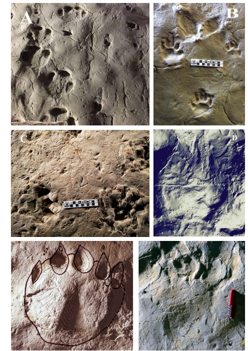
Figure 4. Vertebrate animal footprints and tracks of the sheltered excavation areas on the geological trail of the area. A) Rhinoceros, ungulate and small mammal (or reptile). B) Nimravid and rhinoceros footprints with raindrop traces. C) Carnivore, ungulate and bird. D) Meszarosia discoveria n.g. n.sp. KORDOS; E, Beardog footprint (Bestiopeda maxima KORDOS); F, Aquaraptor alligatoroides n.g.n.sp. KORDOS & MÉSZÁROS.
Paleohabitat Reconstruction: Land (Rhinoland) and Shallow Water (Crocodilia)
Between the discoveries of footprint-bearing surfaces in 1900 and 2015, the habitat was reconstructed in a very simple way: terrestrial animals lived close to a stream or seaside under a subtropical climate. Based on the recently discovered thin layers of sandstone with a great diversity of interfluvial vertebrate tracks, another model was constructed in which the terrestrial bank (after the rhino tracks) was named Rhinoland intercalated with the wetland habitat or Crocodilia (Fig. 5).
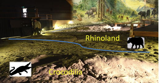
Figure 5. Crocodilia and Rhinoland in the Tasnadi Hall of the geological trail
The bird tracks describe the characteristics of the lacustrine–fluviatile wetland situation. The footprints were mostly found on small sandy hills. For Rhinoland, characteristic tracks and trackmakers are rhinos, artiodactyls, carnivores, rodents (?), and on the sandy interfluvial hills birds. On the surface developed during wet periods, crocodilian, turtle, and varanid lizard tracks are dominant, while rhinos, artiodactyls and most of the carnivores are absent.
Track Concentrations in the Alpine-Carpathian Foothills During the early Miocene
During the early Miocene, some molasse-like sediments of similar age to Ipolytarnóc containing several track types of wetland birds and different mammals were deposited. The most important sites in the region are in the southern Alps at Digne, France (Beaudoin & Gigot 1971), the Untere Süsswassermolasse of Goldauer Bergsturz, Switzerland (Bräm 1955), and the Carpathian foreland in Romania and Ukraine (Panin & Avram 1962; Vialov 1966). According to the development of Central and Eastern Paratethys in Central Europe (Hámor 1985), molasse sediments accumulated by fluviatile-lacustrine-marine transport in depressions before the elevation of the Carpathian arch. This was associated with similar sedimentological features and faunas in different species. The regional distribution of tracks indicates an early Miocene collision of the African and European plates (Fournier et al. 2008).
Conservation History, Management Issues, Geotourism and Potential
Unfortunately, after surviving the volcanic catastrophe and over 17 Ma, the fossil finds could not withstand the onslaught of humans. Not just laymen, but scientists also caused irretrievable damage to the track and other fossil remains. Devastation had already begun in the year of discovery of the petrified pine, in 1836. Kubinyi at first thought of ex situ protection. He had the trunk unearthed and dragged out of the ravine, and the trunk was broken into pieces and then transported to nearby private museums. Later, realizing his mistake, Kubinyi had the remaining exposed parts covered with earth. Unfortunately, neither Kubinyi’s efforts, nor the building which was erected around 1860 to shelter the most endangered parts of the giant pine, could save the trunk from vandalism. Local people collected fragments of it for building stone and whetstone, swarms of “souvenir collectors” broke pieces from it, local landlords took bigger fragments of it as ornaments for their gardens, and it became a favored material for gravestones. Museums were also frequent visitors and contributed to the damage. Even the protective shelter was destroyed within two decades after its construction.
The shark teeth also attracted attention. The local people imaginatively called them petrified bird tongues and sold them in necklaces to the tourists who came to visit the site. The footprint sandstone proved to be ideal for road and house building and was even used to build the protective cellar for the fossil tree. Locals held picnics on the eroded surface of the paleosurface and danced on top of the prehistoric footprints. Paleontologists excavated and collected the most exotic tracks and left the exposed surfaces open to weathering and to private collectors; several tracks were lost, and only sketches of them survived. Those who cared for the site stopped publishing papers, because they realized that new discoveries generated a new flow of collectors to the site. The most pro-conservation scientists finally decided to stop further excavations, until everything already exposed was sheltered (Tasnádi Kubacska 1976).
Even though the site became officially protected in 1944, several decades went by before the protection became effective. Permanent staffing with guided tours along the established geological study trail in the early 1980s was the solution. Excavated areas, where tracks were exposed, were covered by conservation buildings, and new interpretation trails were opened later, officially during the 8th Congress of the Regional Committee on Mediterranean Neogene Stratigraphy, September 15–22, 1985. Guided tours were introduced on the geological trail in 1986, and the site has become a favored tourist destination.
Land ownership problems were solved when the area was acquired by the Hungarian State, and the Bükk National Park Directorate gained land manager status; thus, the factors impeding conservation management were controlled. The site was declared part of the Pan-European natural heritage by the Council of Europe in 1995. It is a European diploma-holding site now and is on the Hungarian Tentative List of the World Heritage.
After 2005, further geotourism developments entered the digital era with 4D time travel movies and an augmented reality sandbox experiment, and these interactive exhibitions can provide half-day programs to visiting families. In the great conservation hall, holographic animations reconstruct the animals of the Miocene epoch and GUIDE@HAND applications are available in three languages on the trail network. Because of the newest geotouristic developments, Ipolytarnóc has become an important nature tourism destination in the region (Fig. 6A). It is the main gateway to the Novohrad-Nógrád UNESCO Global Geopark with a visitor center propagating the heritage of the trans-border geopark.
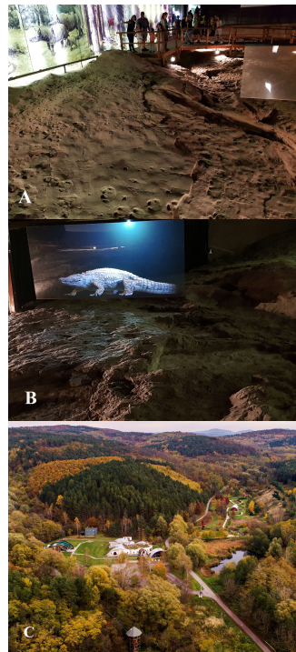
Figure 6. Interpretation of fossil resources in the Tasnadi Conservation Hall and the surroundings of the Ancient Pine visitor center. A) visitors at the sheltered excavation. B) fossil crocodile animation above its 17 Ma footprints. C) the visitor center is in the center of the Miocene Park. Photograph courtesy of the BNPD.
Excavations and scientific studies of the site are ongoing, with new discoveries and huge potential. The achievements of research in the last 180 years are a valuable heritage for the geosciences. The area provides widespread recreational-educational opportunities based on its unique geoheritage. New projects target the rehabilitation of some worn-out, old infrastructures, including the protective buildings and further reinterpretation efforts following discoveries of the new excavations.
Yet there are some serious, challenging problems at the Ipolytarnóc Fossils site. It is understaffed, and management depends partly on the income generated by geotourism and the covid-19 pandemic lock-down in 2020–2021 hit it substantially. Financial stability is an issue, as are the seasonality of tourism and the need to maintain permanent employment. Further, some consequences of climate change raise new challenges for the preservation of the exposed footprint surfaces.
Nevertheless, being a member of the Global Geoparks Network and taking part in the work of the Fossils Working Group of the European Geoparks Network (EGN) led by Prof. Dan Grigorescu have established a new platform for the recognition and international scientific cooperation of the site. Its homepage is available in three languages at: www.osmaradvanyok.hu
References
Abel O (1935). Vorzeitliche Lebensspuren. G. Fischer, Jena, pp.160–167.
Bartkó L (1985). Geology of Ipolytarnoc. Geologica Hungarica, Series Palaeontologica. 44:1–71.
Beaudoin B & Gigot P (1971). Figures de courant et traces des pattes d’oiseaux assiciees dans la molasse Miocene de Digne, Bases Alpes (France). Sedimentology. 17:3–4.
Böckh H (1902). Report of the director. Magyar Királyi Földtani Intézet Jelentése 1900-ról. p. 33–34. (in Hungarian)
Bräm H (1955). Fährten von Wirbeltieren aus der subalpinen Molasse des Bergsturzgebietes von Goldau. Eclogae Geologicae Helvetiae. 47:406–417.
Fournier M, Agard P & Petit C (2008). Micro-tectonic constraints on the evolution of the Barles half-window (Digne Nappe, southern Alps). Implications for the timing of folding in the Valensole foreland basin. Bulletin de la Société Géologique de France. 179:551–568.
Hably L (1985). Early Miocene plant fossils from Ipolytarnóc, N Hungary. Geologica Hungarica, Series Palaeontologica. 45:73–255.
Hámor G (1985). Geology of the Nógrád-Cserhát area. Geologica Hungarica, Series Geologica. 22:1–307.
Koch A (1903). Tarnócz Nógrád megyében, mint kövült czápafogaknak új gazdag lelőhelye (Tarnócz in Nógrád county, as a new rich finding place for petrified shark teeth). Földtani Közlöny. 33:22–44. (in Hungarian)
Koch A (1904): Pótlék a tarnóczi alsómediterrán homokkő czápafaunájához (Supplement to the lower Mediterranean sandstone’s shark fauna of Tarnócz). Földtani Közlöny. 34:202–203. (in Hungarian)
Kocsis L (2007). Central Paratethyan Miocene shark fauna (Ipolytarnóc, Hungary). Geologica Carpathica. 58:27–40.
Kocsis L (2016). Újabb eredmények az ipolytarnóci cápafogas rétegről, illetve annak faunájáról (New results of the shark teeth-bearing layer’s fauna of Ipolytarnóc). – In Szarvas, I. (ed.): Ősmaradványok nyomában. Ipolytarnóc földtani megismerése I. (Tracing fossils. Geological research of Ipolytarnoc, volume I.) Bükki Nemzeti Park Igazgatóság, Eger. 53–76. (in Hungarian)
Kordos L (1985). Footprints in Lower Miocene sandstone at Ipolytarnóc, N Hungary. Geologica Hungarica, Series Palaeontologica. 46:257-415.
Kordos L & Morgós A (1988). Lower Miocene footprints as studied at Ipolytarnóc in 1986. Földtani Intézet Évi Jelentése. 1986-ról, pp. 493-451.
Kordos L & Mészáros I (2018). Bird tracks the lower Miocene shore of Rhinoland and Crocodilia at Ipolytarnóc, Hungary. Evolução (Revista de Eistoria e Pré-História), Ser 1. Num. 2, p. 38-41. (Edição Especial; As Aves: Evolução, Paleontololgia, Arquezoologia, Artes e Ambientes), Lisboa
Korpás L (2003). Az ipolytarnóci homokkő új szedimentológiai modellje. A vulkáni esemény kronológiája és központjának rekonstrukciója. (The new sedimontological model of Ipolytarnoc, Chronology of the volcanic event and reconstruction of its center. Manuscript, Magyar Karszt- és Barlangkutató Társulat – Bükki Nemzeti Park, Budapest-Eger, pp. 16. (in Hungarian)
Kretzoi M (1950). Az ipolytarnóci lábnyomos homokkő földtani kora és az akvitán kérdés. (The geological age of the footprint-bearing sandstone of Ipolytarnóc and the aquitanian debate). Földtani Közlöny. 80:259–261. (in Hungarian)
Kubinyi F (1842). Nógrádmegyében Tarnócz helység határában található óriásnagyságú kövesült fáról és azt környező kőnemekrõl földisméreti tekintetben. (About the giant petrified tree found at the neighborhood of Tarnócz in Nógrád county and about its surrounding rocks from the perspective of Erath sciences). M. O. T. V. M. 2: 67–70 (only in Hungarian)
Kubinyi F & Vahot I. (eds.) (1853). Magyarország és Erdély képekben. (Hungary and Transylvania in pictures) – Pest. I:5–14. (in Hungarian)
Lambrecht K (1912). Magyarország fosszilis madarai (Fossil birds of Hungary). Aquila. 19:288–315. (in Hungarian)
Lambrecht K (1933). Handbuch der Paläornithologie. Berlin
Lóczy L (1910). Führer durch das Museum der Kgl. ungar. Geolog. Reichsanstalt. Földtani Intézet Népszerű Kiadványai, 1:29–30.
Pálfy J, Mundil R, Renne P, Bernor RL, Kordos L, Gasparik M (2007). U-Pb and 40Ar/39Ar dating of the Miocene fossil tracksite at Ipolytarnóc (Hungary) and its implications. Earth and Planetary Science Letters. 258:160–174.
Panin N, Avram E (1962). Noi urne de Vertebrate in miocenul Subcarpatiler Rominesti. Studia si Cereştari de Geologie, Geofizica, Geogrrafie Romine. 7:455-484.
Szarvas I (2007). Case study of the Ipolytarnoc track site, Hungary. New Mexico Museum of Natural History and Science Bulletin. 42:303–308.
Tardy J, Kordos L & Szarvas I (2003). A global comparative analysis of the palaeohabitat of Tarnoc. VÁTI, Budapest.
Tasnádi Kubacska A (1976). Az ipolytarnóci lábnyomos homokkő őséletnyomai (The ichnofossils of the footprint-earing sandstone in Ipolytarnóc). Földtani Intézet Évi Jelentése 1974-ről., pp. 77-94. (in Hungarian)
Thenius E (1948). Bemerkungen über die angeblichen Anchitherium- und Amphicyonidenfährten aus dem Burdigal von Ipolytarnóc (Ungarn). Sitzungesberichte des Österreische Akademie der Wissenschaften, Mathematisch-Naturwissenschaftliche Klasse 1., 157:223–230.
Vialov OS (1965). Neogene Stratigraphy of the Molasse of the Pre-Carpathian region (in Russian). Naukova Dumka, Kiev
Vialov OS (1966). Sledi zisnedeljatelnosti organizmov i ih paleontologitseskoe znatsenie. Naukova Dumka, Kiev.
Vialov OS (1985). The tracks of Vertebrata in the Lower Miocene of Hungary. Paleontologicheskii Sbornik. 22:71–78.
Vialov OS (1986). Artiodactyl traces from the Lower Miocene of Hungary. Paleontologicheskii Sbornik. 23:63–69.