Introduction
Volcanic geoheritage is an increasingly recognized value of abiotic nature (Németh et al. 2017a; Németh et al. 2017b; Sheth et al. 2017; Zangmo et al. 2017; Fepuleai & Németh 2019; Kil et al. 2019; Dóniz-Páez et al. 2020; Quesada-Roman et al. 2020). Volcanic geoheritage in many protected landscapes forms the core aspect of nature conservation, as well as having geotouristic and geoeducation values (Showstack 2015). Volcanism is a very attractive aspect of Earth processes, and fascinates visitors (Erfurt-Cooper 2011; Erfurt-Cooper 2014). Volcanic rocks, even in old geological settings, function as a key aspect of storytelling about the evolution of abiotic nature as their formation is associated with processes that fit into the human timescale (Wang et al. 2014; Migon & Pijet-Migon 2016; Szepesi et al. 2017; Zacek et al. 2017). This is especially true of those eruptive rocks from small volcanic edifices, commonly defined as monogenetic volcanoes (Smith & Németh 2017), which provide a very human scale to the understanding geological processes, and in active regions their formation can be experienced (Németh & Moufti 2013; Németh 2016 a,b; Németh 2017). With well-designed geoeducational programs that are linked to geotourism ventures, volcanic regions are one of the main attractions in terms of geological and geomorphological processes (Khoshraftar & Farsani 2019; Migon & Pijet-Migon 2019; Molenda 2019; Raska et al. 2019; Beltran-Yanes et al. 2020; Bidias et al. 2020). Following this, many regions put significant energy into utilizing the “magic” of volcanism to get the society to engage with geology (Ozkaymak et al. 2017; Asrat 2018; Erfurt-Cooper 2018; Kaygili et al. 2018; Careddu & Grillo 2019; Galindo et al. 2019). Volcanic geoheritage is a particularly powerful tool to develop resilience against volcanic disasters, hence an increasing number of geoeducational programs are looking for the link between geoheritage values and their potential usage for volcanic hazard resilience programs (Petrosino et al. 2019; Guilbaud et al. 2020; Fepuleai et al. 2021; Guilbaud et al. 2021).
While such works normally focus on polygenetic, long-lived stratovolcanoes, where repeated and recurrent volcanic eruptions occur from a vent that is relatively stable in its position in human time scales, recently the same approach has been taken in dispersed volcanic regions, or volcanic fields. Volcanic fields are commonly defined as a group of volcanoes that erupted over a relatively short period of time in geological terms, forming small volcanic landforms with very distinct time frame when they formed (Smith & Németh 2017). In active volcanic fields, where Holocene or Pleistocene volcanoes formed, volcanic geoheritage is crucial in transmitting volcanic hazard resilience messages, as while the field is active, actual activity can be absent over many generations, such as in the Auckland Volcanic Field in New Zealand where the last eruption occurred about 600 years ago (Hopkins et al. 2021). This concept is normally difficult to convey to the population in the absence of direct experiences of volcanic eruptions. But once a new vent opens, within days to years new volcanic geosites may develop often with dramatically different consequences or hazards. This scenario is even more pronounced in areas where very small volumes of melt rising can interact with ground and surface waters, and small volume of magma rise can generate impactful explosive events considered to be high and unpredictable hazards (Kereszturi et al. 2014).
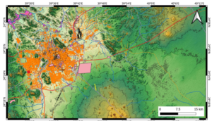
Figure 1. Outline of the greater Al Madinah region just north of the Harrat Rahat Volcanic Field on a DEM with 50 m contour lines. Red dot is the Al-Du’aythah volcanic cones region. Yellow line is the 1256 CE historic eruption site fissure. Pink zones are the major construction site, while light purple marks the orchards including palm farms. Orange and dark green refer to the built environment of the city.
Most of the volcanic fields in the Arabian Peninsula show such characteristics. Just south of Al Madinah City (Fig. 1), the Harrat Rahat is a monogenetic volcanic field where explosive magma and water interaction driven eruptions are known from the Pleistocene, commonly associated with more evolved magmas like trachyte (Moufti & Németh 2013). The latest eruption of the volcanic field formed a chain of scoria cones along a 2.3 km long fissure that emitted lava flows over 12 km in length well within the current city limit of Al Madinah (Camp et al. 1991). About 500 monogenetic volcanoes of this volcanic field formed, and they are overwhelmingly scoria cones, that are mild to moderately explosive in their activity, probably grown over days to years, but there is little evidence that they had intermittent phreatomagmatic (magma and water interaction driven) explosive phases during their eruptions (Downs et al. 2018). This was a paradoxical situation especially around Al Madinah City, in a low-lying region with suspected good shallow subsurface water sources. Until 2012–2013 there was no evidence known for explosive magma-water interaction driven eruptions in this region. In 2012-13 however, some accidentally opened communal scoria pits identified some locations where very thin 1–2 m basal tephra was exposed that were clearly phreatomagmatic in origin (Murcia et al. 2015). As an immediate response to these findings, proposals were prepared and published to highlight the key geoheritage elements of the young volcanism around Al Madinah, particularly pointing out the significance of four cones named as Al-Du’aythah volcanic cones just on the western edge of the Al Madinah urban areas (Moufti et al. 2013). The same cones due to their young morphology were also provisionally suggested to be a “legendary” source event of volcanic eruptions mentioned in some historic oral traditions, hence referred to as the AD 641 cones (Moufti et al. 2013). Recent geological mapping, however, provided radiometric dates that were much older, around 14 ka (Downs et al. 2018). These four cones are in interesting locations in relation to the growing Al Madinah urban area (Fig. 1). They are along a Neoproterozoic horst that follows a NW-SE trend (Figs. 2, 3).
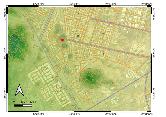
Figure 2. Vicinity of the Al-Du’aythah volcanic cones on a DEM with marked road network and satellite image underlay.
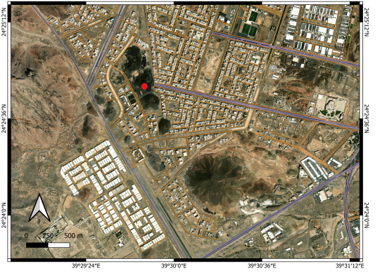
Figure 3. Vicinity of the Al-Du’aythah volcanic cones. Red dot marks the studied cone.
A magnetotelluric survey conducted in 2012-13 also confirmed fluid, inferred to be water (water saturated sediments) about 300–400 m below the surface beneath these cones, further confirming the potential that phreatomagmatic activity likely took place at least in the initial phase of three of these scoria cones (Murcia et al. 2015). This revealed typical evidence of phreatomagmatism in the exposed thin lapilli tuff, and tuff breccia (Fig. 4). Here we report additional evidence to support this idea from new exposures with more than a 5 m thick pyroclastic succession (Fig. 5). The new exposures are the result of some local community quarrying of construction material, rubbish pit opening and some expansion of failed development of some orchards nearby. This new finding highlights the urgent need to prevent further degradation of this location as they hold crucial information on understanding the eruption scenarios future eruptions in the region may follow.
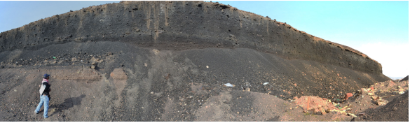
Figure 4. Outcrop with exposed phreatomagmatic tephra at the base of the section (light color) in the western section of the cone exposed in 2013.
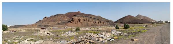
Figure 5. Panoramic view in 2023 of the western section of the central north cone with exposed thick phreatomagmatic tephra overlain by dark scoriaceous ash and lapilli. The image faces towards the east (direction of the center of Al Madinah City).
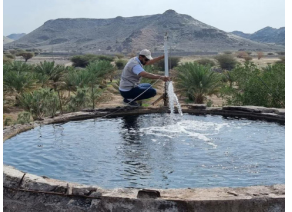
Figure 6. Abundant ground water flow from a well just north of Al Madinah City.
Method
We conducted site visits in 2023 to check visually the status of the location. This visit was part of a field campaign of the Saudi Geological Survey to collect direct field observation data to better characterize the potential eruption scenarios in the greater Al Madinah region. During this field visit, direct photo documentation of the status of the sites was completed. As the last detailed study dates to 2012-13, a complete satellite imagery study was performed by applying Google Earth Pro satellite imagery through the available historic data sets. The data sets go back to 2004, providing an excellent array of spatial information to trace landform changes over a nearly 20-year period (2004–2023). This is valuable information, as ten years ago such diverse image data sets were not accessible, and the resolution of the available images was unsuitable for the detail of observations needed. In addition, a basic survey was conducted through available Sentinel satellite imagery. This data set has a useful image library since 2017, hence only the last six years of land use changes can be determined. The highest resolution of these images is 9 m, so they cannot be used to identify great detail of the cones, but they are sufficient to see the context of the location of these cones within the basin of Al Madinah. We used three types of satellite images: moisture index map (sensitive for water-rich substances or surfaces); short wavelength infrared imagery (SWIR; sensitive to vegetation and water availability in the near surface regions); and false color (urban) images normally used to locate vegetation and urbanization. For spatial information, ALOS -PALSAR Terrain Corrected digital elevation models were obtained that provided 12.5 m resolution elevation data. This data was not useful directly to trace the small volcanic cone morphological changes. It was instead used to characterize the morphology of the greater Al Madinah Basin. On these elevation maps, key man-made features such as highways, buildings, mosques, and orchards were also shown, extracted from spatial data available from the Open Street Map services. Direct field observations were also accompanied by basic macroscopic documentation of the exposed volcanic lithologies.
Results
Greater Al Madinah Basin
The greater Al Madinah Basin is a lowland just north of the Harrat Rahat volcanic field. The basin itself has functioned as an oasis since its early settlement and provides an agricultural base for the growing population. Al Madinah became an important center for agriculture for growing dates, market vegetables and herbs such as the famous mint (Sayed & Masrahi 2023). All this indicates that the region had access to water from dug wells and surface water for centuries. Groundwater is abundant beneath the surface but highly saline and nitrate-rich around the established standards for irrigation and drinking (Al-Harbi et al. 2006; Bob et al. 2016). Most of the ground water is suitable for irrigation of salt-resistant crops (El Maghraby et al. 2013). The aquifers are recharged through rainwater filtration over century long cycles (Al-Harbi et al. 2006). In modern times drilled wells reaching depths of 200-300 m lift water at temperatures ranging between 35 and 50 °C (Fig. 6). Higher water temperature water wells are located just north of the city, mostly for community use or market gardening and perhaps associated with some relatively weak geothermal processes. Water is channeled across the entire volcanic field and exists in various wells within or in the marginal regions of the fields like in the SE (Fig. 7). All these observations and current uses for the region indicate that relatively shallow ground water sources are abundant in the region. This originally suggested that geologists look for evidence of magma and water interaction in the region where a large number of Pleistocene to Holocene volcanoes formed. Sentinel satellite imagery of the greater Al Madinah region in the January to March 2023 period was studied, when the region experienced an unusually wet season. The elevated moisture is clearly visible (Figs. 8– 10).
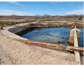
Figure 7. Ground water from a well at the southeaster edge of the Harrat Rahat Volcanic Field. Note the trachytic lava domes in the background.
Figure 8. Sentinel SWIR Satellite Image of the greater Al Madinah region. Note the young lava flows, the green regions where vegetation flourish, and the large temporal lake marked by dark blue. The image was taken on 27 March 2023.
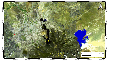
Figure 9. Sentinel False (Urban) satellite image showing the urban expansion of Al Madinah City well. The image was taken on 27 March 2023.
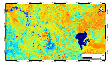
Figure 10. Sentinel Moisture Index map showing moist (water availability) zones in blue while dry regions are dark orange or red. The image was taken on 27 March 2023.
Site Degradation
After finding new exposures during the 2023 field campaign, we explored land degradation of the Al-Du’aythah volcanic cones. Following the available satellite data sets of the Google Earth Pro service, we selected the best possible images by visual inspection. Each image was georeferenced and incorporated in a GIS database within Q-GIS for comparison of the geometrical changes (e.g., surface area and cliff positions) between 2004 and 2023. We intended to select images that were taken in wintertime where the contrast is high due to moisture content. The earliest available image date back to November 2004 when the cone shows clear and intact morphological elements (Fig. 11). The eastern edge and limit of the cone still show nearly the original extent and mark a steep eastern slope with some original erosional ravines.
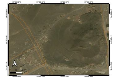
Figure 11. The oldest available historic Google Earth Pro satellite image from August 2004. Orange lines show the present roads.
The central part of the cone is still in its primary morphological appearance, marking a “softer” surface area in the west, that is distinct from a south-easterly crater zone with steep features and a complex lava dome at its northern edge. In this image, it is also evident that the cone itself has a complex crater morphology suggesting an actual eruptive vent shift in a very short period. It is also indicating that the western, smoother cone was somehow overgrown by the eastern cone complex. Further from the cone toward the NW it is obvious that a layer of dark ash covers the otherwise smooth morphology, all indicating some sort of magma fragmentation style change in the growth of the volcano from a more explosive (hence fine-grained ash producing) phase to more regular scoria fall producing eruptions.
The cone already suffered some quarrying on its SW side in the 2004 image, but the excavation was likely for local community need rather than large-scale landscape modifying quarrying. These conditions were relatively stable until May 2009, when the scoria pit became more obvious and deeper, with some local road construction initiated on the southern margin of the cone (Fig. 12). By May 2012, a two-lane asphalt road construction started in the western side of the cone while by August 2013 (Fig. 13) new housing development created a line of houses in the immediate vicinity of the cone on the eastern side. This is the scenario when first-time evidence of a basal tuff ring was found in thin beds at the eastern side of the cone. During, this time the northern side of the cone became a communal and likely uncontrolled rubbish pit (Fig. 13).
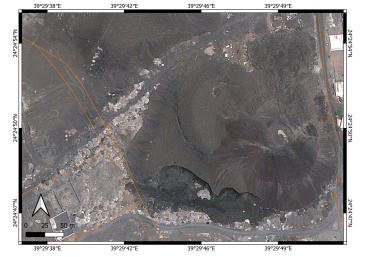
Figure 12. May 2009
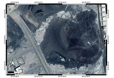
Figure 13. August 2013
By January 2015, land development started along the NW side of the cone with some landscaping and cut back of the cone (Fig. 14) with significant modification of the cone by October 2016. This stage was accompanied by rubbish dumping and some orchards in the entire western sector of the cone (Fig. 15). By December 2018, the entire western sector of the cone suffered significant landscaping and cut back as well as developing a date orchard and some organized rubbish pits providing clean cliff surfaces suspected to have excellent outcrops (Fig. 16). By August 2020, a new clearance removed the former rubbish pit but made the cone cut back about 10-15 m, and losing its entire distal section (Fig. 17). This time, despite the significant alteration of the original landform, a functioning orchard guaranteed the relatively tidy appearance of this side of the cone, potentially offering excellent outcrops. About a year later, this situation had changed by removal of the orchard, some clearance and landscaping, apparently an attempt at tourism and geoconservation development (Fig. 18). This situation remained more or less the condition of the cone up to 2023 (Fig. 19). Today, some clearance is apparent, but also, as the land is open to the public, local rubbish dumping has started as well as the gradual collection of communal use of scoria. By now the eastern side of the cone has also been cut back a further 5–10 m, forming a characteristic cliff side deeply cut into the core of the cone and losing its original morphology. Similarly, an articulated circular zone has been developed on the western edge that has left only the core of the former tuff ring. In the crater zone digging activity made the cone’s original crater morphology hard to recognize, leaving behind few segments that can be recognized probably only by trained experts. Interestingly, the cone's northern side where a small lava dome and some short lava flow poured out remained intact, probably due to its hard nature which made it difficult to blast it off. The cone now has its heavily modified core complex only.
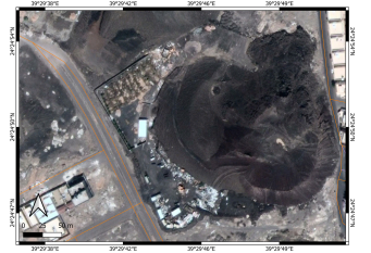
Figure 14. January 2015

Figure 15. October 2016
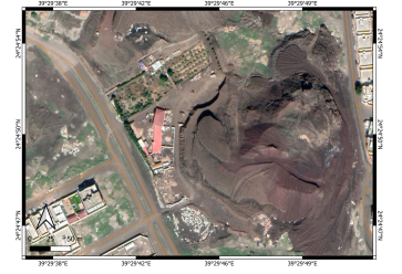
Figure 16. December 2018
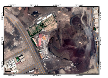
Figure 17. August 2020
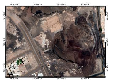
Figure 18. July 2021
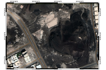
Figure 19. March 2023
Further Evidence of Phreatomagmatism
During the dramatic transformation of the original landform, many new outcrops formed. These new outcrops expose the basal region of the complex but small cone, showing an extraordinary eruption history, which has not been considered earlier at such scale. At the northern edge, immediately beneath the outpouring lava flows initiated from the central lava dome, tuff breccias are exposed in at least two units (Fig. 20). This tuff breccia grades into a thinner bedded and finer grained tuff breccia toward the west (Fig. 21) where cauliflower bombs, granitic rocks from the basement and some chilled basaltic fragments together suggest explosive phreatomagmatic eruptions to be responsible for their formation. Such coarse grained breccias were suspected but not known in 2012–13 and have not been reported yet from this location, or anywhere else in the Harrat Rahat volcanic field. These breccias are best interpreted as proximal pyroclasts of a tuff ring or small maar volcano. These tuff breccias are also grade into an accidental lithic dominated lapilli tuff toward the west (Fig. 22) and show repeated fine–coarse alternation of pyroclastic beds indicating the pulsating nature of explosive phases. The tuff layers showing plastering and presence of accretionary lapilli attest to their phreatomagmatic origin (Fig. 22). The new exposures in the west cut directly into the crest of a former tuff ring where the basal phreatomagmatic pyroclastic succession reaches nearly 10 m in thickness (Fig. 23), which is gradually draped over by typical black scoria and lapilli erupted from the easterly vents of the cone complex. These outcrops are new. Now the new outcrops form a coherent array of deposits that show vital information to support explosive phreatomagmatism as a key eruption scenario which needs to be incorporated into volcanic hazard estimates of the greater Al Madinah region.
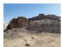
Figure 20. Tuff breccia beneath the lava outflow in the northern sector of the cone.
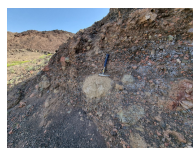
Figure 21. Accidental lithic-rich lapilli tuff and tuff breccia in the NW sector of the cone. Note the granite clasts and fractured metavolcanics from the basement.
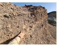
Figure 22. Coarse grained lapilli tuff abundant in accidental lithic fragments (mostly granite) with fine tuff with accretionary lapilli between coarse grained units.
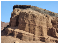
Figure 23. Thick phreatomagmatic lapilli tuff unit with fine stratification and unsorted nature with abundant accidental lithic fragments suggesting base surge origin of most of the beds based on the unsorted nature of the deposits, some cross stratification and plastering effect of fine ash over larger pyroclasts. Note: the dark scoria ash and lapilli mantling the phreatomagmatic succession.
Discussion
It is evident that the volcanic cone suffered a dramatic anthropogenic alteration in the last 20 years. Tracing the original cone outlines using historic satellite images is useful to follow the spatial changes (Fig. 24). Following the outline of cone changes it is evident that about a third of the surface area of the original cone has been removed within 20 years (Fig. 24). This means that the distal deposits of the cone are gone forever and that the integrity of the landform is compromised. As integrity forms a very fundamental aspect of geoheritage valorization, such loss normally translates to the loss of geoheritage value (Newsome & Johnson 2013; White & Wakelin-King 2014; Tavares et al. 2015; Zangmo et al. 2015; Pena et al. 2017; Cetiner et al. 2018; Koroglu & Kandemir 2019; Rodrigues Ferreira et al. 2019; Yaseen et al. 2019; Yoon 2019; Bidias et al. 2020; Mikhailenko et al. 2020; Pourfaraj et al. 2020; Vereb et al. 2020).
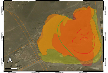
Figure 24. Outline of the cone base change over time. Yellow green is the state in 2004, light orange is in 2013, while the dark orange is the current situation. Green line marks the tuff ring crest, while the red lines mark the original, visible crater rims of the eastern scoria cone that host a small lava dome and lava outflow toward the north.
If we look at the original central crater morphology, we can see clearly that the cone’s original crater rim has been modified so much that it is hard to recognize its original shape (Fig. 24). It is also important to note that there are some “gains” along the margins depending on the actual excavation status of the cone. Steep cliffs can be eroded after rainfall, and the material washed away is creating ash covered fans along the newly excavated but subsequently abandoned cliff faces. This is an issue, as while now the cliff faces expose very interesting sections vital to understand the eruptive mechanism of the cone, but if such cliff faces are not stabilized or maintained, they can erode away rather quickly leaving behind a debris fan-covered face where the original texture and bedding can no longer be seen.
The Al-Du’aythah volcanic cones, and their studied central northern cone complex provide clear evidence for the debate about geoconservation of small volcanic cones like scoria cones, their natural resource values and geoheritage. It has long been discussed how we approach human-modified sites, including active and abandoned quarries. On the one hand, quarrying and removal of sectors of the cones destroy the original landform, while on the other hand due to the excavation, the visitor can access sites that are vital to understand the geological processes responsible for the formation of the geoform itself (Németh et al. 2021; Nieto-Torres et al. 2022; Rito et al. 2022). Natural resource extraction through quarrying of high-quality scoria is tempting as the product is useful for construction (Moufti et al. 2000; Sabtan & Shehata 2000; Herrera-Franco et al. 2022). However, such values conflict within an ecosystem/geosystem services concept (Bobylev et al. 2022). Abandoned quarry sites also attract ad hoc communal excavation and rubbish damping reducing the integrity and the aesthetic value of a geosite (Németh et al. 2021; Tessema et al. 2021; Krieger 2023). Such fragile geosystems also need attention after their protection level is raised as visitation can damage their integrity as well (Santos et al. 2017; AbdelMaksoud et al. 2018; Kong et al. 2020; He et al. 2023). Effective geotrails, even across abandoned quarry sites, can carry significant value for geoeducation (Guilbaud et al. 2021; Németh et al. 2021; Sallam et al. 2022; Singtuen & Anumart 2022; Alberico et al. 2023).
The Al-Du’aythah volcanic cones demonstrate this dilemma perfectly. Research carried out ten years ago predicted the potentially fundamental role of explosive phreatomagmatism during the initial phase of producing scoria cones in areas where ground water was expected such as in the greater Al Madinah basin. This notion was supported by a thin veneer of phreatomagmatic tephra. Ten years ago, information that was highly speculative has now become definitive from the exposed thick sequence of such deposits. This means that, while the destruction of the original landform was significant, it led to a dramatic loss of its geoheritage value from a landform integrity and aesthetic point of view, however, the new exposures provide significant added value to the scientific understanding of the formation of this volcano.
This information is transferable to other locations and therefore has significant scientific value. If we accept the general trend to express and define abiotic features as geoheritage, it should be based on the scientific value, and the human intervention (regardless of whether it is intentional, or unintentional) that provides a strong increase in geoheritage values. This clearly is a paradoxical question. Similar concerns have been raised recently in many locations where extensive quarrying of basalt (and andesite) from monogenetic volcanoes for construction removed most of the cones, leaving behind only the core of the volcanoes such as in the Chaîne des Puys World Heritage site (Németh et al. 2021). Especially in Europe such quarries are abundant and most of them provide essential scientific information to our current understanding of how monogenetic volcanoes work (Németh et al. 2021). Such exposed interior parts of the cones include interaction features between lava lakes and tephra rings, diatreme breccias or collapsed cone sectors within crater infilling deposits help to advance our scientific knowledge of eruption mechanisms. Such information would never have been accessible, as naturally occurring buttes are rare and if they exist, the associated debris fans commonly cover key exposures. So, such quarry sites have significant scientific values, but the artificial modification of the original landscape can clearly cause massive scars on the natural landscape.
Many large monogenetic volcanoes such as those in Spain, France, Hungary, or Germany, provide locations where a proper geoconservation strategy can create a fantastic learning environment, which commonly forms the core of the geotourism programs. For instance, one of the headquarter sites of the Bakony-Balaton UNESCO Global Geopark in Hungary is in Hegyestű, a former abandoned quarry with super columnar jointed basalt outcrops exposed during the active quarrying (Pál & Albert 2021a, b; van Wyk de Vries et al. 2022). Similarly, Vulcanica (https://www.vulcania.com/en/), a major European geotourism center within the “Chaîne des Puys - Limagne fault tectonic arena” UNESCO World Heritage site offers one of the most spectacular experiences to see into the core of a monogenetic volcano (van Wyk de Vries 2013; van Wyk de Vries et al. 2014; Delcamp et al. 2014). In that location, the original volcanic geoform is hardly recognizable. Adopting this vision, the Al-Du’aythah volcanic cones should be treated similarly.On the one hand, what has been removed cannot be returned. There are some notions to restore original geoforms such as maar craters in the Eifel region in Germany (Koziol & Feelsberger-Ruuti 2011) and from South Korea’s Jeju Island (Shik et al. 2014), but to do that is more a bioconservation and landscape issue than a geological restoration. As the Harrat Al Madinah has abundant scoria cones, a visitor can be directed to landforms where original geoforms are still present such as the 1256 CE historic eruption site just about 15 km to the east of Madinah, while at Al-Du’aythah, the current state of the cone must be utilized for geoeducation and geotourism. As the Al-Du’aythah volcanic cones are the only location where we can look inside a monogenetic volcano of the region of Harrat Rahat at a scale that allows us to see how the eruptive products record the interface between wet to dry explosive phases, this location carries a high scientific value in the regional context. Moreover, the Al-Du’aythah volcanic cones also provide a globally significant aspect of monogenetic volcanism, namely the volume issue. If very low magma volume is involved in an eruption, it is likely that it will be very sensitive to local environmental effects such as the presence of ground and/or surface water. In the case of phreatomagmatic explosive eruptions, the impact or the so-called volcanic footprint of the eruptions will be much larger than if the same volume of magma just erupted in a “dry” manner, a conceptual model considered recently (Németh et al. 2012). Therefore, the Al-Du’aythah volcanic cones carry a vital aspect of volcanic hazard education, and the site should be treated as a flagship location to scale our understanding of this type of volcanism and its geohazards.
Conclusion
In this short report we provided a report of our recent revisit to a key geological site in the western region of the urban area of Al Madinah City. This location was the first site in the Harrat Rahat volcanic field where clear evidence been identified in the geological record to demonstrate that in the early stage of the basaltic eruptions explosive phreatomagmatism was a key and violent process. The first paper (Murcia et al. 2015) on this subject rightfully recorded and communicated this finding but remained rather conservative about the extent of the interpretation as the exposed and preserved deposit was thin and had been recovered only from sporadic and not interconnected outcrops. Ten years after this report and its recommendations to keep an eye on the geoconservation strategy of the Al-Du’aythah volcanic cones, a revisit was concluded in 2023. The revisit located great thicknesses of well exposed and very characteristic deposits interpreted to be of explosive phreatomagmatic origin. As a follow up, checking the accessible historical satellite imagery through Google Earth Pro provided data of nearly 20-year period since 2004, showing the loss of the surface area of the original cone, but also the newly emerged exposures hosting unique and superb outcrops confirming the original inference on the role of phreatomagmatism. Our work here also demonstrated that phreatomagmatism might have been far more widespread in the region, but in places where substantial magma was available during the eruption, the original tuff rings were likely covered completely, and the phreatomagmatic pyroclastic successions have never been exposed; not as at the Al-Du’aythah volcanic cones. In this respect, despite the dramatic human modification of the original volcanic geoform, the exposures provide fundamental values to define this location as a key geosite with high geoheritage value.
However, to manage all the concepts outlined above, there an effective geoconservation strategy is required. Geoconservation is the key to the fate and the future of the Al-Du’aythah volcanic cones. The original volcanic geoform has reached a metastable state when slight changes in land use (like new communal rubbish dumping or local excavation of raw materials) can damage the newly exposed geosites to a level at which the geoheritage value has been lowered to a minimum. This is when an effective geoconservation strategy should be co-developed between research organizations, councils, and local communities. This work also highlights the role and purpose of geoconservation. Also, without geoconservation research, this transdisciplinary research cannot be conducted effectively and the geoheritage value would deteriorate quickly.
Acknowledgments
Logistical support by the Saudi Geological Survey is highly appreciated to conduct site visits. Two anonymous reviewers’ comments, the Editor-in-Chief's (Prof. Mike Benton) and the Technical Editor's (Ms. Mahshid Pezeshki) suggestions helped to clarify our work.