Introduction
Ever since Darwin (1842), coral reefs have been seen as complex ecosystems with high geological significance. Zooxanthellate corals produce large amounts of calcium carbonate in their skeletons and build limestone structures of varying dimensions, in many cases with kilometer-scale areal extents, which are commonly preserved in the rock record as fossil reefs. Due to their symbiosis with zooxanthellae, corals behave as plants needing well-illuminated habitats in warm waters such as those in the intertropical latitudes. These narrow ecological requirements make fossil zooxanthellate corals excellent palaeoenvironmental indicators: rocks where they are found were formed in shallow, warm marine waters.
The sedimentary rocks in the Cabo de Gata-Níjar UNESCO Global Geopark, well exposed in the arid landscape, are an outstanding archive to reconstruct the paleoenvironmental and paleogeographic evolution of the area. They also contribute to understanding of the paleoceanographic and paleoclimatic evolution of the western Mediterranean during the Neogene. Among these, the Messinian coral reefs witness the last stage of growth of zooxanthellate corals in the Mediterranean Sea after millions of years of inhabiting the region. The convergence of the Arabian and African plates with the Eurasian plate closed the connections of the Indian Ocean with the Mediterranean Basin in the middle Miocene, interrupting the long-lasting existence of a circum-tropical ocean. The separation from the Indian Ocean and the progressive global cooling eventually led to the disappearance of the Mediterranean coral reefs (Perrin & Bosellini 2012)
The fossil coral reefs and associated deposits in the geopark are excellent, well-exposed, and accessible examples for practical training in geology and paleontology at different educational levels. They are also privileged sites for the diffusion of general concepts and research results in these fields.
Geological Setting
The Cabo de Gata-Níjar UNESCO Global Geopark (Almería, SE Spain) is located in the Cabo de Gata volcanic province, part of the Betic Cordillera at the western end of the European Alpine orogenic belt. The Cabo de Gata area constitutes the southern block of the NE–SW sinistral strike-slip Carboneras fault system (Montenat & Ott d’Estevou 1990) (Fig. 1) that separates the volcanic province from the rest of the Iberian Peninsula.
Volcanics compose most of the extent of the Geopark, but Neogene sedimentary rocks intercalate with and overlie the volcanic rocks (Fig. 1). These sedimentary rocks accumulated in small entrances of the Mediterranean Sea and their changes throughout time generally reflect the palaeogeographic changes related to emergence and uplift of the surrounding volcanic reliefs. The Messinian coral reefs, ca. 6.4 to 5.5 Ma in age, occur on top of volcanic buildups of radiometric ages from 8.7 to 8 Ma (Bellon et al. 1983; Di Battistini et al. 1987; Fernández-Soler 1996, 2001; Duggen et al. 2003).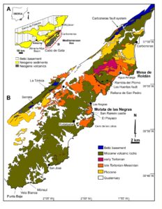
Figure 1. Location and geological map of the Cabo de Gata-Níjar UNESCO Global Geopark in SE Spain. The upper Tortonian-Messinian rocks include the Messinian reefs (after Pineda-Velasco et al. 1981a, b).
The Messinian Reefs
Messinian coral-reef limestones and associated deposits can be traced over extensive areas in Cabo de Gata. They are best exposed on the northern hillside of La Molata de las Negras, where the lateral distribution of deposits related to coral reefs can be observed (Fig. 1), and on top of an isolated hill on the northern side of Mesa de Roldán (Fig. 1).
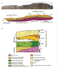
Figure 2. A. Panoramic view and lithostratigraphic interpretation of the northern slope of La Molata de las Negras. B. Stratigraphy of La Molata de las Negras (after Galindo-Zaldívar et al. 2019).
La Molata de las Negras
In this outcrop, Messinian reef-related deposits unconformably overlie the underlying sedimentary and volcanic rocks (Fig. 2). Three units can be distinguished according to
reef types and stratal geometry and patterns. The lower unit is up to 30 m thick with beds generally gently dipping basinward to the northeast. At the southwestern end of the outcrop are well-bedded coarse-grained calcarenites-calcirudites, with fragments of molluscs, coralline algae, and corals as main components. Small patches of Porites corals are scattered within the bioclastic sediment. These deposits laterally pass into finer-grained bioclastic calcarenites, which surround coral patch reefs (bioherms), and basinward include reef blocks, coral breccias, coarser-grained calcarenite beds, and occasional silicified diatomites. The biggest and best-exposed bioherm consists of a framework of Porites and Tarbellastraea in its lower part with irregular, contorted platy colonies with finger-like protuberances. Stick-like Porites (P in Fig. 3A) and tabular and massive Tarbellastraea (Fig. 3B) form the upper third of the bioherm (Martín et al. 2003; Bourillot et al. 2009). Coral gravels and bioclastic calcarenites appear between the colonies and on the flanks of the bioherm. Seawards of bioherms, coral blocks appear either dispersed in fine-grained beds or concentrated in channels with erosional bases together with bioclastic breccias and volcanic clasts (Fig. 2B). These channels have reduced lateral continuity and they occur at several horizons within the unit, together with redeposited carbonates. These latter features can be observed in the surroundings of the San Ramón castle north of El Playazo beach (Fig. 1), at the toe of the eastern slope of La Molata (Martín et al. 2003).
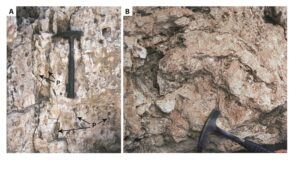
Figure 3. A) Branching Porites colony from the middle part of the largest coral bioherm in La Molata de las Negras. Note the stick-shaped morphology of coral (P). Hammer is 33 cm in length. B) Hemispherical Tarbellastraea colony from the upper part of the largest coral bioherm in La Molata de las Negras. Hammer head is 18 cm in length.
The lower-unit deposits formed on a relatively steep ramp with bioclastic shoals and small coral patches in the area closer to the paleoshoreline. Coral bioherms grew seawards of the shoals on finer-grained sediments. Debris from the reefs, including large coral blocks, bioclasts and lithoclasts from shallower areas moved downslope as sediment gravity flows that accumulated in channels or spread as small beds intercalated with fine-grained autochthonous sediments.
The second reef unit is up to 70 m thick and comprises prograding clinobeds, in most cases thinning downslope (Fig. 2B). Porites reefs occur at the top of some clinobeds and change laterally to reef-talus breccia with coral blocks and coarse bioclasts, which in turn pass downslope to coarse-grained calcirudites with abundant Halimeda and coralline algae, and finer-grained calcarenites in distal positions (Franseen & Mankiewicz 1991; Franseen et al. 1993). In each phase of reef development, a Porites reef fringed the paleoshoreline. Basinwards, debris from the reef with gradually decreasing grain-size accumulated downslope.
The third coral reef unit at Cerro de la Molata onlaps an erosional surface on top of the lower Messinian fringing reefs with local evidence of subaerial exposure (Franseen et al. 1993; Franseen & Goldstein 1996). Volcaniclastic conglomerates and sands, including fragments of older carbonates, occur locally on the erosional surface. The overlying deposits consist of bioclastic and oolitic calcarenites and microbial-carbonate (stromatolite and thrombolite) domes (Fig. 2B). Lenses of mollusc-shell concentrations as well as Porites colonies occur among these sediments. Lenses of volcaniclastic conglomerates and sandstones are intercalated within the limestones. Coralline red algae, bryozoans, and echinoids are common fossils (Bourillot et al. 2010). These deposits formed on a shallow-water marine platform that developed on the underlying erosional surface (Franseen & Goldstein 1996).
Mesa de Roldán
In a hill on the northern side of Mesa de Roldán, reef limestones of the lower Messinian units are cut by an erosion surface. This surface is overlain by oolitic calcarenites and a Porites patch reef that can be correlated with the third unit at La Molata de la Negras (Esteban & Giner 1980; Riding et al. 1991) (Fig. 4). The patch reef consists of vertical stick-like Porites colonies (P in Fig. 5) with horizontal cross bridges in the lower part, and laminar Porites colonies in the upper part. Coralline algae, encrusting foraminifers, and microbial crusts coat the coral skeletons (MC in Fig. 5). Molluscs, coralline algae, and echinoids occur in the matrix in the voids within the framework (Riding et al. 1991).
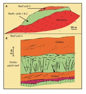
Figure 4. A) Geological sketch of Mesa de Roldán. Tortonian volcanics (lower and middle slope) are overlain by Messinian carbonates. B) Detailed section of the topmost carbonates with a small Porites patch-reef intercalated within oolitic limestones (after Riding et al. 1991).
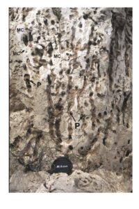
Figure 5. Stick-like Porites colony from the base of the small patch-reef intercalated within the oolites in Reef unit 3 in Mesa de Roldán. The coral skeleton (P) is heavily leached and karstified. Thin, stromatolitic micrite crusts (MC) coat the coral skeleton. Lithified, bioclastic internal sediment infills the remaining voids. Lens cap is 5.5 cm in diameter.
Palaeogeography and Uplift History
Fringing reefs and other nearshore deposits such as beach, submarine-cliff, and trough cross-bedded sediments can be used to delineate the shoreline at the time of their formation. The spatial distribution of lithologies indicates the position of shallow-water marine platforms and relatively deeper basins in each time slice. In Cabo de Gata, coral reefs and related deposits outline the paleogeography of the area during the Messinian once the volcanic activity had ceased (Fig. 6). The Carboneras fault system (Fig. 1) strongly influenced paleogeographic trends of the Cabo de Gata area, in which NE–SW, N150E and approximately N80E orientations of paleocoastlines were the most important.
In the early Messinian, the fringing reefs depict a N45E-aligned large island covering most of the present-day Geopark. In the La Tórtola hill (Figs. 1, 6), the fringing reefs encircled a volcanic dome forming an atoll-like elliptical structure. In the Las Negras area (Figs. 1, 6), an embayment opened to the northeast (Martín et al. 2003). The volcanic reliefs and the upper Tortonian shallow-water deposits in the northern Cabo de Gata subsided and were covered by the sea, becoming a relatively deep-water setting in which marls laterally equivalent to the reefs accumulated (Martín et al. 2003). The Las Huertas fault (Rambla del Plomo) (Figs. 1, 6) was the northern boundary of the shallow-water reef platform at the northern margin of the main island. Coral reefs also colonized the high at the volcanic dome of Mesa de Roldán. Proximal reef slope deposits in sections along shoreline cliffs suggest that submarine highs or emergent reliefs, probably connected to the main island, extended offshore of the present-day coast from Punta Javana to Agua Amarga (Martín et al. 2003) (Fig. 6).
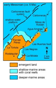
Figure 6. Paleogeography of the Cabo de Gata area during the early Messinian. Reefs grew on the shallow water platforms (modified from Martín et al. 2003).
An erosional surface with evidence of subaerial exposure (Franseen et al., 1993, 1996) separates the lower Messinian reefs from the overlying upper Messinian carbonates in La Molata de las Negras and Mesa de Roldán. This erosional surface is the local record of the Mediterranean sea-level drawdown associated with the Messinian Salinity Crisis (Riding et al. 1998; Braga et al. 2006). Mediterranean sea level recovered during the late Messinian and re-flooded the platforms on top of the lower Messinian reefs, returning to a paleogeography similar to that of the early Messinian.
Uplift Patterns
The elevation above modern sea level of shoreline deposits from each time slice can be used to estimate the patterns and rates of uplift of an area. In Cabo de Gata the reef rocks at the western margin of the major, N45E aligned paleoisland experienced the maximum uplift since the Messinian, with a rate of approximately 50 m/Ma (Martín et al. 2003). The elevation of the Messinian rocks decreases eastwards to the present-day coast. The elevations of most Messinian deposits north of the Rambla del Plomo, in the hanging wall of the N150E-oriented Las Huertas fault (Fig. 1), are consistently lower than those on the footwall around the main island (Rellana de San Pedro). Only the Messinian rocks on the Mesa de Roldán dome, which was a high area delimited by N45E and N150E faults (Brachert et al. 2002), show elevations like those of coastal deposits on the main island.
The late Quaternary to present-day shoreline is a cliffline (Harvey 2001), related to faulting, and combines N45E and approximately NS strikes. The shaping of the modern shore took place after the Early Pliocene since Lower Pliocene deposits are exposed at sea cliffs tens of metres high (Martín et al. 2003).
Uplift amounts and rates of Upper Miocene–Lower Pliocene sedimentary rocks in Cabo de Gata are like those of the upper Neogene rocks in nearby eastern Betic basins, such as the Almería–Níjar and Vera basins. Despite volcanic influences, the Late Neogene uplift history of Cabo de Gata seems connected to the rest of the cordillera.
The Last Coral Reefs in the Mediterranean Sea
The Messinian coral reefs in Cabo de Gata, as at other coeval reefs in SE Spain and the central and western Mediterranean, are the last coral reefs after hundreds of millions of years (Flügel & Flügel-Kahler 1992). Since the Triassic, coral reefs inhabited the circum-tropical Tethys Ocean, which separated the northern and southern hemisphere plates that resulted from the division of Pangea. The relative movements of those plates progressively closed the Tethys, dividing its former extent into the modern oceans. The Mediterranean was isolated from the Indian Ocean by the convergence of the Arabian and Eurasian plates about 14 Ma in the middle Miocene (Rögl 1998; Bialik et al. 2019). This isolation from a major coral region, source of new species, and the progressive cooling of the Earth since the Miocene climatic optimum (Westerhold et al. 2020) promoted the gradual decrease in coral diversity in the Mediterranean (Perrin and Bosellini 2012). This decrease resulted in low-diversity reefs such as those remaining in the late Messinian, formed finally only by Porites, one of the most resilient corals in the world. Connection with the cold Atlantic waters through the Straits of Gibraltar prevented the growth of zooxanthellate corals in the region after the early Pliocene (5.3 Ma) (Martín et al. 2010)
Geoconservation Strategy
The Cabo de Gata-Níjar UNESCO Global Geopark belongs to the European and Global Network of Geoparks since 2001. The geopark was established in the territory of the regional natural park of the same name created by the Junta de Andalucía (the Andalusian regional government) in 1987.
The Andalusian regional government promoted the Andalusian Inventory of Georesources (AIG) in the frame of the Andalusian Strategy for Integrated Geodiversity Management aimed at guaranteeing the conservation of geodiversity and promoting the role of geological heritage as a socioeconomic asset for the sustainable development of the territory. The AIG was integrated in its entirety by the Spanish Geological Survey (Instituto Geológico y Minero de España, IGME) in the Spanish Inventory of Places of Geological Interest (IELIG).
The inventory currently includes 662 sites across Andalusia, 33 of which, of different geological nature, were catalogued within the limits of the Geopark. Most are outstanding examples of volcanic rocks or landforms related to volcanic activity, such as the Punta Baja and Vela Blanca domes (Fig. 1). Other sites are geomorphological features witnessing active erosion or sedimentation processes, such as the dune field of Monsul (Fig. 1). Among the sites in the Geopark, those illustrating Neogene sedimentary deposits stand out as the best examples of their category. In particular, the Mesa de Roldán reef and the Molata de Las Negras platform have been the subject of intense research and have been used frequently as a natural laboratory to teach geology from basic levels to highly specialized carbonate sedimentology.
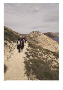
Figure 7. Public-use trail along the eastern slope of the La Molata de las Negras locality, crossing fore-reef deposits, well exposed at the sea cliffs in the middle ground.
Geoconservation and Dissemination Measures
Different actions have been carried out to publicize, conserve, and value the geological heritage in the Cabo de Gata-Níjar UNESCO Global Geopark:
- Dissemination of the value of geological heritage, and the work carried out by UNESCO, through its Earth Sciences and Geoparks Program, the European Geoparks Network (EGN), and the Global Geoparks Network (GGN), through brochures and digital publications available at Cabo de Gata-Níjar UNESCO Global Geopark website.
- Establishment of a network of 16 public-use trails to make localities of geological interest accessible. Two of these trails are devoted to the fossil reef sites of La Molata de las Negras (Fig. 7) and Mesa de Roldán. Free brochures are available pointing to major features of the landscape, vegetation, and geology that can be observed along each trail.
- Signposting with interpretive panels. The fossil reefs are described and interpreted in two panels at the two localities mentioned above (Fig. 8).
- Specialized publications, including the “Geology of the arid zone of Almería. An educational field guide” (Villalobos, 2003) stands out, and includes a chapter on Cabo de Gata-Níjar UNESCO Global Geopark, with two sections dedicated to fossil coral reefs (Fig. 9).
- Conservation measures, such as fences, restrictions on access to road traffic, restoration of possible damages, and surveillance of the areas of greatest geological value and geosites with a high influx of visitors.
- Awareness campaigns and workshops on the geology of the Geopark, and conservation of geological heritage. Among them, it is worth highlighting the European Geoparks Week and the program ‘Geopark in Winter’. Since 2018, the latter program has included guided geological routes every weekend from February to April and talks about the geology and paleontology of the area addressed to a general audience. Some years the field excursion organized during the Geolodía (Geology Day) by the University of Almería takes place in the Geopark.
- Preparation of a Map of Places of Geological Interest of the UNESCO Cabo de Gata-Níjar Global Geopark, where summary information of all the sites and their locations are offered.
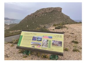
Figure 8. Interpretative panel of the reef at the top of the small hill at the northern end of Mesa de Roldán.
As a result of the continued efforts to promote geotourism as an alternative to classic sun and beach tourism, currently several companies offer guided geological routes in the Geopark. Although ancient volcanoes and volcanic rocks are the focus of these routes, fossil reefs and their meaning regarding the evolution of western Mediterranean climate always draw the interest of participants.
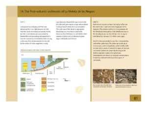
Figure 9. One of the pages dedicated to Messinian reefs in the La Molata de las Negras from the “Geology of the arid zone of Almería. An educational field guide” (Villalobos, 2003). This is a didactic guide to support teaching professionals at different levels and self-interpretation of geological features in the Geopark and nearby areas in the Almería province.
Conclusions
Messinian coral reefs are outstanding components of the Neogene sedimentary cover on volcanic rocks of the Cabo de Gata-Níjar UNESCO Global Geopark.
These reefs occur in three successive units. The lower reefs were built by Porites and Tarbellastraea, which grew on carbonate ramps. Diversity decreases in the second unit, which consists of Porites fringing reefs. The last Messinian reefs are small Porites patches that occur on top of an erosion surface probably coeval with the Mediterranean Messinian salinity crisis.
These reefs are the endpoint of decreasing zooxanthellate coral diversity in the Mediterranean basin during the Miocene following the disconnection of this sea from the Indian Ocean and global cooling.
The reef outcrops are well exposed and accessible and constitute a natural laboratory for practical training in geology and paleontology at different educational levels. They are increasingly the focus of geotourism activity, as evidence of changes in geography and climate in the western Mediterranean region.
Conflict of Interest
The authors declare that they have no conflicts of interest.