Introduction
The numerous applications of Geographic Information Systems (GIS) and remote sensing used in geoheritage and geotourism can be summarily grouped under the nomenclature ‘Geographical Information Technologies (GIT)’, that being GIS, remote sensing techniques such as image processing and Global Positioning Systems (Napieralski et al. 2013). The ways in which these GIT tools are currently (and could potentially) be applied within the geoheritage field are many and varied. Some of these technologies will be of great support to the field, and others are simply digital means of performing existing tasks, sometimes with a time or financial saving.
Presently, use of GIT tools in the fields of geoconservation and geotourism ranges from non-existent to extremely sophisticated techniques and approaches. These approaches, which could potentially (and increasingly, already) assist practitioners and researchers to collect, interpret, visualise and communicate inventory and ideas, have not to date been described and contextualised specifically for a geoconservation audience.
In this paper, we:
- Describe, using narrative discourse and the findings from semi-structured interviews, the way in which geoconservation and geotourism researchers and practitioners are already using GIT Tools;
- Present a short, but comprehensive, review of literature that describes the use of GIT tools in technical approaches and for purposes otherwise central to the stages in the geoconservation process (from inventory collection to communication of prospective geotouristic experiences); and,
- Present a case study and workflow analysis of GIT tools being used to collect, interpret, and communicate a geological inventory.
It is our aim, therefore, to document the ways that GIT tools are being used in geoconservation and geotourism, and to inform readers of the ways that these tools could be used to address common issues in the geoconservation process regarding repeatability of methods, accurate boundary delineation, quality image capture for ex situ analyses, communication of inventory, and geotouristic experience planning. We have written the paper in a format designed for readers who may be familiar with the geoconservation process, but may not have used GIT tools before, or in particular geoconservation applications and approaches.
How are practitioners and researchers already using GIS and remote sensing in geoconservation?
In late 2018, we conducted interviews with 39 of the worlds’ most prominent geoheritage and geoparks academics and practitioners (Williams et al. 2020). Almost 30% of participants (6/8 academics and 5/8 practitioners from Asia, the Americas and Oceania) indicated that they were using drones in geoheritage management and research, with a further 14.3% (3/4 academics) having the intention of using drones and other GIT in future work (Fig. 1a). One practitioner stated:
“Drones, 3D models are useful to impress people for communication and interpretation.”
Despite participants actively describing how they have observed an increase in usage of ‘common’ GIT tools like Unmanned Aerial Vehicles (UAV), over 50% of participants (10/16 academics) were not using drones and did not have any intention of using them. Instead, GIS was much more widely used with over 78.6% (13/22 academics) of participants employing GIS in their work (Fig. 1b), as illustrated by one practitioner:
“(GIS) is used for mapping and providing information to tourists through the website and app.”
Another practitioner stated that GIS is useful in:
“making an inventory - to protect geosites you need very accurate spatial boundaries of geosites.”
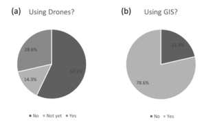
Figure 1. Usage of drones (a) and GIS (b), by 39 prominent geoheritage and geoparks researchers and practitioners after Williams et al. (2020).
The most prominent uses of GIT tools described by participants were in the storage of geoinformation, monitoring degradation, and communicating geoheritage values through maps, web-GIS and mobile applications. UAVs, commonly known as drones, are being increasingly used for geomorphological studies, accessing geosites in difficult terrain as decision-support tools and 3D models for communications. Participants reported that the most common roles were in education products (19.8%), setting the extent of geosites, geodiversity sites, or protected areas boundaries (12.6%) and inventorying (13.5%). One academic stated:
"GIS allows you to put geoheritage in its geographical context, an inventory on its own is not enough."
The practitioners cited delineating boundaries, education and planning equally as their most common roles while the top three most common roles for academics were education, inventorying and monitoring. One practitioner stated:
“(GIS has a role) in boundaries, planning, inventory, community engagement. Even fostering sense of place!”
Other roles given for GIS/remote sensing in decreasing commonality were monitoring, planning, mapping, tourism, access in difficult and/or remote terrain, tourism, geomorphology, field assessment and geodiversity assessment. UAVs are finding increasingly more usage with two practitioners with expertise in the management and interpretation of geoparks, commenting that:
"Drones are revolutionary in understanding geomorphology" and "are cheap and data rich, great for limited resources too."
How have GIT tools been used in published research (on geoconservation and geotourism)?
Published applications of GIT tools in geoconservation and geotourism fall into three categories. First are those that provide decision-support in producing inventories, evaluating geosites and planning geotourism initiatives. Less commonly, GIT tool are used for decision-making – such as identifying prospective geodiversity sites for geotourism areas and in the evaluation of the most appropriate geosites assessment criteria for inventory, some of which can be achieved through Multi-Criteria Decision Analysis GIS-MCDA. Overwhelmingly GIT tools are used in geotourism and education communications.
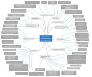
Figure 2. Mind map showing the wide range of uses for GIT in the field of geoheritage, with examples of each application provided in references.
The use of GIT tools are not yet very common as decision-making tools in geoheritage and geotourism research and practice. This is because the data (e.g. population density data, mineral occurrences, cultural heritage information) related to assessment criterion is often not available and basic geoconservation decisions (inventory purpose, criteria, geological frameworks) have not been made for many parts of the world. In geoconservation and geotourism, these attributes for conservation are expressed as values. The Brilha (2016) method comprehensively and quantitatively allows the practitioner to rank qualitative values in a number of domains – scientific, potential educational use, potential touristic use and degradation risk. Though originally intended to be a geosite assessment method it also provides a useful framework through which to interpret landscape level values and opportunities for decision-making at provincial and national levels.
When applying the Brilha (2016) method to landscape scale activities, it has become apparent that there are a number of examples of the application of GIT tools to the assessment or detection of values in geoheritage and geotourism. With respect to scientific value (Table 1), research has been most popular in using GIT tools for geoheritage detection, lithological classification, geosite monitoring and terrain analysis, enabling decision-support and decision-making for the evaluation of representativeness, integrity and rarity. Communication-based GIT tools, including UAV outputs, geoinformation databases; cartographic and digital mapping products are useful for understanding integrity, key localities and scientific knowledge. No research has been conducted in producing a universal geological framework or in forming guidelines around measuring geodiversity elements at an appropriate scale. Opportunities exist to address these issues and develop a universal classification system using an XML schema or web ontology language, removing some of the ambiguity when evaluating scientific value.
In the domain of potential educational use and potential touristic use (Table 2), research has been focused on proximity and buffer analyses, UAV and satellite surveying and monitoring, which assists in the decision-support and decision-making of many educational and touristic criteria including safety, logistics, uniqueness, geological diversity and observation conditions.
Table 1: GIT tools applied to the scientific evaluation of geosites using the Brilha (2016) assessment method. Y = yes, N = no.
Criterion | Definition by Brilha (2016) | GIT Tool? | References | Technique Used | Role of GIT |
Representativeness | The appropriateness of the geosite to illustrate a geological process or feature that brings a meaningful contribution to the understanding of the geological topic, process, feature, or geological framework | Y | (de Carvalho et al. 2013; Eeckhaut et al. 2007; Mwaniki 2016; Năpăruş-Aljančič et al. 2017; Otto et al. 2018; Saadi et al. 2008; Suma et al. 2010) | Geoheritage detection techniques e.g. wavelet-based analysis, fault modelling and lineament mapping, karst depression detection, landslide detection. Geoheritage classification e.g. XML and ontological systems | Decision Support |
Key Locality | The importance of a geosite as a reference or model for stratigraphy, palaeontology, mineralogy, etc. | Y | (DPIPWE n.d.; Gallerini et al. 2011; Kiernan 1995; Poiraud et al. 2016) | GIS storage of key geosites (e.g. Tasmanian Geoconservation Database), terrain analysis to enhance visualisation of geosites | Communications |
Scientific knowledge | The existence of published scientific studies about the geosite
| Y | (DPIPWE n.d.) | GIS storage of scientific literature related to each geosite e.g. Tasmanian Geoheritage Database | Communications |
Integrity | The conservation status of the main geological elements
| Y | (Fiore 2013; Fernández-Lozano & Gutiérrez-Alonso 2017; Hackney & Clayton 2015; Nex & Remondino 2014; Ng 2016) | UAV and satellite monitoring of geosites | Decision support, Decision making Communications
|
Geological Diversity | The number of different geological elements with scientific interest | Y | (Benito-Calvo et al. 2009; Bishop 2013; Chen et al. 2006; Corsini et al. 2009; Cracknell & Reading 2014; Dewitte et al. 2008; Hjort & Luoto 2012; Kozlowski 2004; Kruse 2013; Qiu et al. 2015; Najwer et al. 2016; Melelli et al. 2017; Simon et al. 2016; Stepišnik & Trenchovska 2018; Waldhoff et al. 2008; Yürür et al. 2018; Zwolinski et al. 2016) | Lithology classification and surface composition, terrain analysis, geodiversity assessments | Decision support Decision making |
Rarity | The number of similar geosites in the area of study | Y | (Brandolini & Pelfini 2010; Geological Survey of Brazil 2006; Napieralski et al. 2013; Otto et al. 2018; Pál & Albert 2019; Regolini-Bissig 2010) | Cartographic and digital mapping; spatial queries | Decision support Decision making Communications
|
Use limitations | The existence of obstacles that may be problematic for the regular scientific use of the geosite | Y | (Rutherford et al. 2015) | Proximity analysis | Decision support |
Table 2: GIT tools applied to the assessment of PTU and PEU evaluation of geosites using the using the Brilha (2016) assessment method. Y = yes, N = no.
Criterion | Definition by Brilha (2016) | GIT Tool? | References | Technique Used | Role of GIT |
Vulnerability | The existence of geological elements that can be destroyed by students
| Y | (Fernández-Lozano & Gutiérrez-Alonso 2017; Fiore 2013; Hackney & Clayton, 2015; Nex & Remondino, 2014; Ng 2016) | UAV and satellite monitoring of geosites | Decision-support Decision-making Communications |
Accessibility | The easier and shorter the walk between the means of transportation and the site | Y | (Rutherford et al. 2015) | Proximity analysis of roads and transportation options | Decision-support Decision making |
Use limitations | The existence of obstacles that may be problematic for the development of educative activities | N |
|
| Decision-support Decision making |
Safety | Field activity can be carried out under low risk conditions for students | N |
|
| Decision-support Decision making |
Logistics | The existence of facilities to receive students, such as accommodation, food, and toilets | Y | (Pál & Albert 2019) | Buffer zones to measure the vicinity of accommodation and restaurant services | Decision-support Decision-making |
Density of population | The existence of a population near the site, potentially providing students who will use the site | N |
|
| Decision-support |
Association with other values | The existence of other natural or cultural elements associated with the site may justify interdisciplinary fieldtrips | Y | (Pál & Albert 2019) | Buffer zones to count number of cultural sites | Decision-support |
Scenery | The beauty of the geological elements that could stimulate students’ interest for the site | N |
|
| Decision-support |
Uniqueness | The distinctiveness and the rarity of the geodiversity elements that could stimulate a sense of satisfaction for the visitors | N |
|
| Decision-support |
Observation Conditions | The observation of all the geodiversity elements of the geosite | Y | (Cracknell & Reading 2014; Qiu et al. 2015; Regolini-Bissig 2010; Simon et al. 2016; Waldhoff et al. 2008; Yürür et al. 2018) | Drone survey, satellite lithology classification and surface composition | Decision-support |
Didactic potential (PEU only) | The use of the site by students of different education levels | Y | (Hoblea et al. 2014; Litwin 2008; Lugeri et al. 2017; Luo 2015; Martínez-Graña et al. 2017; Masron et al. 2015;) | Web-GIS for the public, atlas, augmented reality and mobile apps, virtual tours and 3D Models. | Decision-support Communications |
Geological diversity (PEU only) | The number of different geological elements with didactic potential | Y | (Benito-Calvo et al. 2009; Bishop 2013; Chen et al. 2006; Corsini et al. 2009; Cracknell & Reading 2014; Dewitte et al. 2008; Hjort & Luoto 2012; Kozlowski 2004; Kruse 2013; Najwer et al. 2016; Melelli et al. 2017; Qiu et al. 2015; Simon et al. 2016; Stepišnik & Trenchovska 2018; Waldhoff et al. 2008; Yürür et al. 2018; Zwolinski et al. 2016) | Lithology classification and surface composition, terrain analysis, geodiversity assessments | Decision-support Decision making Communications |
Interpretative Potential (PTU only) | The capacity of a geodiversity feature to be easily understood by people with no geological background | Y | (Hoblea et al. 2014; Litwin 2008; Lugeri et al. 2017; Luo 2015; Martínez-Graña et al. 2017; Masron et al. 2015) | Web-GIS for the public, atlas, augmented reality and mobile apps, virtual tours and 3D Models. | Decision-support Communications
|
Economic Level (PTU only) | The level of income of people living near the site suggests a higher probability of it being visited | N |
|
| Decision-support |
Proximity of recreational areas (PTU only) | The existence of well-known tourist attractions in the surrounding area | N |
|
| Decision-support |
Communication-based GIT tools, including UAV outputs, web and mobile applications have been used in understanding didactic and interpretative potential. No research has been undertaken to spatially represent use limitations, density of population, scenery, uniqueness, economic level and proximity to other recreational areas, therefore presenting opportunities to use GIT tools such as overlay and proximity analyses, increasing the robustness of educational and touristic evaluation.
The assessment of degradation risk (Table 3) has been focused on proximity and buffer analyses and using UAV and satellite surveying techniques for monitoring. These applications have enabled decision-making in the detection of deteriorating geological elements and have supported the determination and measurement of accessibility criteria. Outputs from UAVs (e.g. 3D models) were also used as communications for management to understand geosite deterioration. No research has been undertaken yet to spatially represent legal protection, density of population and proximity to areas to cause degradation, presenting opportunities to use similar GIT tools as mentioned above to improve the robustness of degradation risk evaluation.
Table 3: GIT tools applied to the degradation risk evaluation of geosites using the using the Brilha (2016) assessment method. Y= yes, N = no.
Criterion | Definition by | GIT Tool? | References | Technique Used | Role of GIT |
Deterioration of geological elements | The possibility of loss of geological elements in the site as a consequence of fragility and vulnerability | Y | (Fernández-Lozano & Gutiérrez-Alonso 2017; Fiore 2013; Hackney & Clayton, 2015; Nex & Remondino, 2014; Ng 2016) | UAV and satellite monitoring of geosites | Decision-support Decision-making Communications
|
Proximity to areas/activities with potential to cause degradation | Proximity of mining, industrial facilities, recreational areas, roads, urban areas, etc. | N |
|
| Decision-support |
Legal protection | The location of the site in an area with any type of legal protection. Access control refers to the existence of obstacles, such as restrictions by the owner, fences, need to pay entrance fees, mining activities | N |
|
| Decision-support |
Accessibility | The conditions of access to the site for the general public | Y | (Rutherford et al. 2015) | Proximity analysis of roads and transportation options | Decision-support Decision making |
Density of population | The number of persons that live near the site and that can cause potential deterioration to the site due to inappropriate use (vandalism, theft, etc.). | N |
|
| Decision-support |
It can reasonably be stated that the application of GIT to geoheritage and geotourism is increasing, both in rigour, and in global reach. However, this is being achieved against a backdrop of subjectivity in assessment criteria, lack of agreement over the implementation of various technologies, and a limited global understanding or acceptance of geoheritage conservation. There is hence a lot of potential for the increased use of GIT tools, but it must be demonstrably useful, either in reducing time, finance and efforts of researchers and practitioners to understand and implement it, or to make available datasets or information that could not reasonably have been collected, analysed or presented by small groups of researchers and practitioners before.
What needs to be done?
There are a myriad of opportunities to use or configure new GIT tools for the purposes of geoconservation and geotourism decision-support, decision-making and communication. The GIT tools can additionally be employed in all parts of the geoheritage and geotourism planning and data acquisition life cycle. Examples include accessing difficult terrain, boundary delineation, data collection, geoheritage detection, geoheritage classification, geomorphic mapping, storage of geoinformation, monitoring, terrain analysis, GIS modelling, lithology and surface composition classification, communication and promotion. The most significant of these would be the configuration of a global classification system for prospective geosites and geodiversity sites, via the use of open-access schemas and collaborative platforms. Inventory could then be communicated via online platforms, and decision-making (site alternatives, criteria alternatives and substitutions, etc.) tools could be pre-set with site evaluation criteria, enabling new assessors to more easily communicate with the existing frameworks and expectations.
It is the greatest remaining challenge for practitioners and researchers in using GIT tools - accessing modestly-priced, easy-to-use technologies that allow efficient data collection, inventory assessment and communication of values for conservation and tourism purposes. Enhanced GIT tools could allow geoheritage academics and practitioners to communicate geoconservation, geotouristic and geoeducational ideas and outputs easily and globally, helping to solve methodological arguments and values criteria associated with geoheritage and geotourism. At present, this knowledge is constrained at a local or provincial/state scale – but GIT tools and techniques can have global applicability. Therefore, investigating and reflecting on how these tools could be used to solve problems at a range of spatial scales is paramount to assisting in the resolution, scale and inventory in geoheritage and geotourism.
Members of international geoscientific and geoheritage associations could work with geoscientific apps developers to create cross-platform articulation and data translation - giving the practitioner the ability to quickly record large amounts of data with the one device that can assist in qualitative field assessments. Qualitative field assessments, such as those assessing representativeness, integrity, rarity and scientific knowledge appear also to have potential to be improved by a GIT approach using, for instance, a modified mobile collector app to assess prospective geosites and geodiversity sites in Tasmania (hereafter referred to as ‘the case study’ – (Williams & McHenry 2020, unpublished). By providing easy access to the current inventory list and other available data layers such as geology, comparisons and decisions are more easily made within the field, rather than in sometimes an ad-hoc fashion later on. Figure 3 demonstrates the easy link between the use decision-support tools used in the field (using ESRI ‘Collector for ArcGIS’ mobile app) and other GIT tools used to capture aerial footage and communicate inventory. The collector mobile app was setup using a customised geosite feature class with a number of attributes and attribute domains, representing geosite parameters to be collected, which was then uploaded as a web map to ArcGIS Online, to be used in the field.
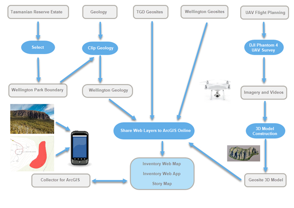
Figure 3. Workflow demonstrating the creation of a web-based inventory using a UAV, ‘Collector for ArcGIS’ and ArcGIS Online Web Maps, Apps and a Story Map.
Collector-style apps may greatly assist in overcoming known challenges in the existing approaches to the collection of field data. The traditional approach generally involves transcribing the notes into electronic form where data can be later entered into an inventory, which may typically be presented as a key or booklet. This process creates redundancy and introduces further human data entry error and is additionally time consuming. One of the major advantages of the GIT approach during data collection is that it requires minimal desktop work and data is only recorded once, increasing the accuracy and reducing the time and workforce required to conduct fieldwork. In the case study example depicted in Figure 4 below, we used the collector mobile app to accurately determine geosite boundaries, and to input field-observed data and photography. UAVs were useful in the field data collection stage, for the purposes of remotely-assessing degradation of geosites and monuments. Additionally, the accurate determination of site and other feature boundaries has implications for protected areas monitoring and planning. In the future, UAVs could be used extensively in geoconservation research to help to determine the integrity of a geosite by allowing large-scale degradation to be assessed, improving the accuracy of geosite assessment and of monitoring of geosite health in general.
Data captured from field surveys along with remotely sensed data from satellites and UAVs can be linked to a GIS to produce geoheritage inventories and maps (decision-support), which can additionally be used to enhance the geotouristic educational experience. Core functions of GIS include the ability to produce geodiversity maps using spatial operations, such as map algebra (Zwolinski et al. 2018) and kernel density (Forte et al. 2018), on multiple data layers. These maps can be used by land managers to be target areas for tourism or conservation (decision-support and decision making).
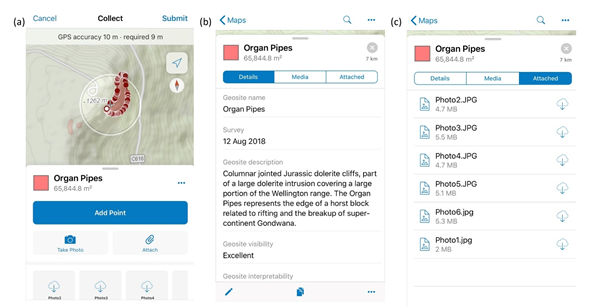
Figure 4. Mobile data collection using ‘Collector for ArcGIS’. Boundaries are accurately delineated (a), geosites are characterised (b) and photographs are directly attached in the field (c).
State-of-the-art visualisation tools linked to a GIS can enhance the communication (via communication technologies) of geoheritage value to stakeholders including government bodies, the scientific community and the public. These technologies, including Virtual Globes, 3-Dimensional (3D) models and web-GIS platforms, can further enhance tourism experiences through the promotion of geoconservation. Figure 4 demonstrates an example of these technologies from the case study example. The 3D model displayed forms part of an online geoconservation inventory, and was created using Structure from Motion (SfM) photogrammetry techniques.
Using the range of GIT tools described in this article and in the case study, educational experiences embedded in geotourism could be transformed from in-person knowledge transfer to the use of digital technologies including virtual globes such as Google Earth, augmented and virtual reality experiences using a GIS. There is even the possibility in the near future for ‘virtual tourism’ – virtual reality experiences allowing virtual tourists to remotely fly UAVs over touristic regions as a low-cost, minimally-invasive touristic experience, without needing to visit the location.
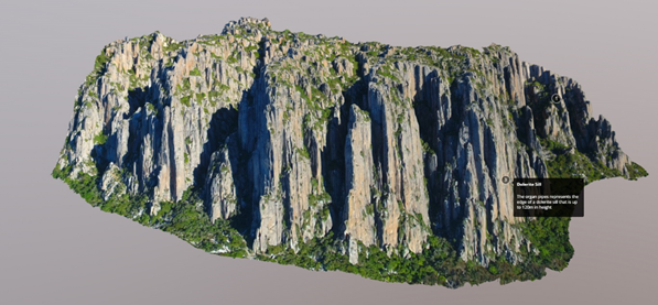
Figure 5. Annotated 3D Model of the Organ Pipes hosted on Sketchfab (link to 3D model https://skfb.ly/6TvWX)
How could the use of GIT tools be possible in routine geoconservation and geotouristic research and practice?
GIT tools can be used across various geographic scales, from local to global, providing communications, decision-support and decision-making tools for geoconservation and geotourism initiatives. Throughout the rest of this section, we will illustrate our discussion of potential GIT tools with actual examples of their first-time use, in the collection, assessment and communication of a regional-scale inventory, in Tasmania, Australia.
A mobile collector app is a useful decision-support tool to undertake field surveys, and a web-based inventory, applicable to specific legislative contexts and evaluation styles, provides an effective decision-support and communications tool (Williams & McHenry 2020, unpublished). Additionally, a GIS multi-criteria decision analysis (GIS-MCDA) designed for a potential global geotourism initiative (crossing multiple tenure boundaries and legislative contexts) can provide a useful decision-making tool. To demonstrate these examples, a quasi-cost-benefit analysis using estimates of costs associated with workforce, time, equipment, training, and finance for ‘traditional’ versus GIT approaches will be presented (Table 4).
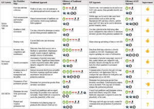
Table 4: Example GIT tools presented in a quasi-cost-benefit analysis using estimates of costs associated with workforce, time, equipment, training, and finance for ‘traditional’ versus GIT approaches
The mobile collector app demonstrates efficiency gains in time, equipment and training across most of the key workflow steps, including field data attributes, field measurements, qualitative assessment and desktop work. Traditional methods tend to use paper-based data collection where the transcription process is prone to errors, and information can be lost completely because of misplaced or soiled data sheets. The GIT approach uses a readily accessible mobile collector app where geosite attributes are recorded quickly by choosing from a list of drop-down menus, increasing the speed of data collection and reducing the number of possible data entry errors. Although this is basic decision-support application, access to the Tasmanian Geoconservation Database (TGD) in Australia, directly on the mobile collector app, has enabled efficient comparison to a list of existing geosites.
The use of mobile technology, using iOS or Android operating systems is familiar to most practitioners, providing a data collection workflow that is very simple and intuitive. For example, a group of 30 students were able to be effectively taught to use this technology with only 30 mins of training. The cost of required equipment has also reduced, not requiring specialist cameras, Pocket PCs etc., as standard smartphones capable of running mobile apps that harness a built-in GPS are now sufficient.
The GIT approach appears to have improved the geosite boundary delineation workflow step, allowing the practitioner to walk around a geosite using the streaming GPS function, where possible, to more accurately capture the extent of a geosite in less time and with less equipment. Traditional methods require recording lots of GPS waypoints where these can be used to create manual polygons during subsequent desktop work. The more common approach, chosen because it is often difficult to traverse the boundary, is to roughly draw a polygon around the geosite using satellite photographs available within a mobile collector app. This cannot be completed using the traditional approach in the field. The use of UAVs further increase the accuracy of boundary delineation and provide large time efficiencies, particularly when geosites are very large. Conversely, surveying with a UAV is associated with larger up-front equipment cost, permits, training and desktop processing, making it prohibitive to some practitioners. Even with the absence of UAV technology, however, there were still advantages in using some simple mobile technologies in boundary delineation – even at the landform scale. Many field measurements such as strike and dip, for example, were taken in the field using a host of free and low-cost mobile apps e.g. ‘Fieldmove Clino’. These apps recorded location and azimuth in addition to recording measurements and landform boundary parameters, each of which could be immediately exported as XML or CSV files.
The Web-based Inventory is a decision-support and communication tool that demonstrates efficiency gains in the key workflow steps of, inventory compilation and geosite assessments. The traditional method for inventory compilation requires manual data entry into a database or spreadsheet whereas the mobile collector app interfaces directly with the inventory, requiring no further data entry. The GIT tool has a higher cost of software but is exceeded by the efficiency gains in workforce and time required to compile and maintain the inventory. Accuracy is also higher, simply since data is not duplicated, reducing the human error aspect of data entry. Geosite assessments are also improved because many criteria can be assessed quantitatively and efficiently using spatial layers, although only a select number of these were implemented in this study. For example, a proximity analysis can easily be used to determine the distance from a geosite to the nearest road. This allows assessments to be completed by less workforce and in less time but may require more training to conduct these analyses.
The communication tools of a web-based inventory are maps and web apps that can be configured for both management and public use (for example, Figure 6). Once in-field data has been collected there is very little time input and no further cost to setup. For example, a web app such as the one used for mobile collector app, can be simply configured to display publicly or to a limited audience such as management. Communications used for a traditional approach may involve producing maps and promotion materials for the public that need to be created from scratch, based on database or spreadsheet information, requiring significant amounts of workforce, time and training to produce these materials resulting in larger financial costs.
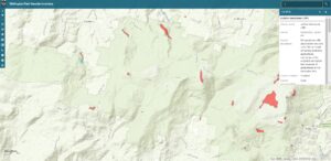
Figure 6. Inventory web app that is used to search and visualise geosite data through a web browser (link to online inventory https://arcg.is/WLuan)
GIS-MCDA can be used as a decision-support and decision-making tool to create a new geotourism experience such as a geotrail. GIS-MCDA involves the following workflow steps; the nomination of the best touristic geosites, determining the route of the trail and then promoting and visualising the geotrail. The nomination of best touristic geosites is a process that takes similar time and human effort in both approaches. Therefore, the main benefit of the GIT approach is to assist in determining the route and enhancing the tourism appeal through the use of spatial technologies such as 3D models. Hence, decisions still need to be made by humans in the conceptualisation of a geotrail, but the ultimate route of the geotrail can be aided by the GIT tool. It is in this sense that the design and planning of the geotourism trail route using GIT workflow steps is significantly different from traditional methods. The GIT approach relies on a quantitative method that allows a path to be determined according to strict trail criteria. The modelling of a trail using GIS-MCDA allows the path to be modelled accurately before fieldwork commences, reducing the workforce, time and equipment required to produce a trail route during initial stages of the planning. The traditional approach relies on substantial fieldwork and expert knowledge making it difficult to adhere to strict trail design guidelines across a large area. The efficiency gains are in all areas except training where substantial GIS knowledge and data is needed for the area being considered.
Together with the communications from the web-based inventory, a web app for a geotrail could easily be created to visualise the geotrail (for example, Figure 7). Walking times for the main trail and side trails along with a subset of the inventory could allow for an engaging virtual geotrail tool that can be used by the public, providing a planning tool for recreation purposes. Some knowledge of web apps is required, although efficiency gains are encountered in workforce and time required to plan a geotrail.
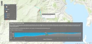
Figure 7. Wellington Park geotrail web app showing the main geotrail, elevation profile and estimated walking time. Side trails are represented by dashed lines (link to geotrail web app https://arcg.is/1DqeSn).
Conclusion
The GIT approach can transform workflows, increase transparency and robustness of methods, and provide effective communications tools for management and the public. There are many other challenges which may be tackled with assistance of GIT tools including comparative geodiversity assessments, classification systems for landforms and representative types, and monitoring degradation of geosites. The future of geoheritage and GIT requires practitioners and academics to progress from point observations, surveys and qualitative assessments, to airborne and space borne remote sensing, geostatistical analysis, object-based image classification and spatial modelling. These tools will not entirely replace field-based mapping and traditional approaches but will provide a suite of tools that may improve the accuracy and efficiently of many steps in the geoconservation strategy. Additionally, GIT might just be the way to facilitate international communication and comparison of inventories, value sets, measurement approaches and degradation assessments that still suffer from a lack of translation between workgroups, organisations and regions.
Acknowledgements
We would like to thank all of the interview participants for their enthusiastic and insightful commentary and greatly appreciate their support of this research. This research was supported by a travel grant to the authors from the School of Technology, Environments and Design, University of Tasmania. Mark Williams received a 2018 Tasmanian Governors Environmental Scholarship, which in part, supported this work. This research was conducted with the permission of the University of Tasmania Human Research Ethics Committee (HREC) - No H0017623.
Conflict of Interest
The authors declare no conflicts of interest.