Introduction
A significant challenge for tourism in the period prior to the closing of New Zealand’s borders on the 19th of March 2020 (Fig. 1), due to the Covid-19 pandemic, stems from the fact that most people’s knowledge of New Zealand prior to visiting may be limited to a series of well-publicised, extremely popular, and well utilised tourist hot-spots (Fig. 1). Examples include Cathedral Cove (https://www.thecoromandel.com/activities/must-do/cathedral-cove/); The Tongariro Alpine Crossing (https://www.tongarirocrossing.org.nz/); and the city of Rotorua (https://www.rotoruanz.com/visit/see-and-do). We describe this as the must-do paradigm (https://www.newzealand.com/us/feature/new-zealand-must-do-experiences/), where the tourist experience of New Zealand is limited to an itinerary based on a series of stand-alone experiences interspersed with periods of travel between destinations (Fig. 1). This approach has seen increasing congestion at tourist hot spots, increasing strain on infrastructure, and competing interests between residents and visitors (see: https://www.stuff.co.nz/travel/news/89010426/its-not-easy-being-beautiful-new-zealand-tourism-boom-comes-at-a-cost-kiwis-say).
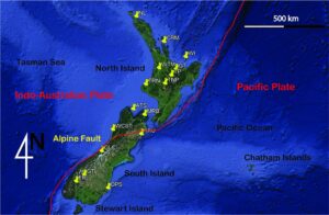
Figure 1. Tourist hotspots of New Zealand and main highways linking them. Map data GoogleEarth Pro. Note the shallow seafloor region around the landmass of the islands of New Zealand, marking the submerged of Zealandia microcontinent,. Red line marks the plate boundary between the Pacific and the Indo-Australian Plate. Abbreviations: NL – Northland; CRM – Coromandel Peninsula; WTM – Waitomo Cave; GT – Geothermal areas around Rotorua; TP – Taupo Caldera region; TNP – Tongariro National Park; TRN – Taranaki Volcano; MRB – Marlboro region; ATS – Abel Tasman National Park and Golden Bay; WCST – West Coast; GLC – Glaciers; GTL – Great Lakes; FRL – Fiordland; OPS – Otago Peninsula and East Otago; KKU – Kaikoura Coast.
We suggest an alternative paradigm, incorporating the concept of slow tourism, gaining increasing recognition in overseas markets and described as “making real and meaningful connections with people, places, food, heritage and the environment” (Caffyn 2012), while others suggest that relationships between visitors and residents can be deeper than commercial transactions (Guiver and McGrath 2015). The instrument through which we propose to facilitate slow tourism is a geoheritage trail in the Coromandel region (Fig. 1). This region is a popular tourist destination, both for local visitors and overseas visitors. However, basic research of visitor attractions promoted in the Coromandel (see: https://www.thecoromandel.com/activities/must-do/coromandel-must-dos/) suggest that a geo-heritage trail as we are proposing is an unexplored opportunity in this region, providing potential to engage the traveller in a journey with multiple opportunities for engagement, exploration, and learning. Therefore, we suggest the proposed study area is an ideal opportunity to research and demonstrate the potential of this new paradigm in providing a visitor experience that empowers the local community through the opportunity to tell the story of its history and landscapes(Tom and Gurli 2015; Gravis et al. 2017; de Vries et al. 2018; Gordon 2018; Scriven 2019; Semeniuk et al. 2019). Equally important, visitors are provided with a holistic experience of our land, culture, and history, through an alternative to already crowded tourist “icons” with standard tourist provisions and facilities (Migon 2014; 2016; Migon and Pijet-Migon 2016; Pijet-Migon 2016; Gordon 2018) .
In line with accepted definitions of geoheritage (Reynard and Brilha 2018) the proposed trail will incorporate and integrate sites of geological, ecological, and cultural significance into a single accessible, engaging, and sustainable visitor experience strongly aligned with a bottom-up approach (Pijet-Migon and Migon 2019) . Our initial research will be based on a thorough assessment of the area leading to development of a geoheritage inventory, subsequently providing a foundation on which to develop the geoheritage trail itself. Ongoing research also has the benefit of refining a model and methodology based on best practices as followed internationally (Brilha 2016; Brilha 2018; Brilha et al. 2018; Forte et al. 2018), subsequently applicable to any region in the country, in partnership with local or regional councils, NGOs, community groups, Government agencies, and relevant iwi (indigenous tribal authorities based on kin groupings). In addition, the process serves as a research tool through direct workshopping with stakeholders and may be used to demonstrate utility as a promotional and marketing tool Subsequent stages of development are a full live virtual geoheritage trail similar to recent developments in many parts of the world (Cayla 2014; Giardino et al. 2014; Lozar et al. 2015; Aldighieri et al. 2016; Rapprich et al. 2017). In addition, a fully implemented on-ground geoheritage trail will be integrated with and complemented by the virtual geoheritage trail.
In this paper, we provide a brief overview of geoheritage and geotourism concepts (Brocx and Semeniuk 2007; Brilha 2016) as they underlie our methodology and framework. We demonstrate that these concepts, as applied to this venture, support a sustainable and low impact engagement with New Zealand’s diverse and dynamic landscapes by providing opportunities for visitors to build a relationship with the land and its history through education, entertainment, and adventure. By focusing on the landscape as a whole, through the integration of the fields of geography, ecology, and cultural history, we provide an experience where the visitor is nurtured as a person and provided with an experience that engages them through storytelling, learning, exploration, and observation.
Geoheritage experiences may appeal to and attract a range of visitors, from experts in their field, amateurs and interested hobbyists, to casual visitors seeking mainly an aesthetic experience (Migon and Pijet-Migon 2016; 2017). This trail and the framework of development and implementation seeks to engage with all types of visitors; however, it may also play a valuable role in engaging the local community in learning, training, and tourism development. Additionally, while we cannot guarantee this venture will draw visitors away from nearby hot-spots, it does provide potential for visitors to expand their experience of the region beyond those hot-spots, thereby providing a more holistic experience to the benefit of both visitors and the local community.
An Overview of Geoheritage Concepts
In the context of this geoheritage trail, the prefix “geo” is interpreted in the sense of its original meaning as a root word meaning “Earth”, or in a more local sense we interpret it as “the place where we stand”. The term geoheritage recognizes the fact that a landscape and its people have a story to tell in the ongoing history of the community which can be told through tourism and education initiatives (Brocx and Semeniuk 2007; Brilha 2018). Geological, cultural, and ecological features with effective interpretation can be used to provide an engaging and dynamic learning experience for visitors, educators, and all community members. Providing a visitor experience that integrates the natural history of the land with the cultural and human history will provide a highly valued visitor experience of local, regional, and international significance.
In the context of New Zealand tourism experiences, geotourism built on geoheritage and geoconservation concepts is relatively undeveloped as a significant foundation of sustainable and low-impact tourism. However, the geoheritage and geotourism field is rapidly developing and expanding overseas, and here we provide some definitions and concepts drawn from international research and literature, demonstrating alignment with principles of sustainable tourism benefiting communities at a local, regional, and national scale (Aotearoa 2018).
We use Geoheritage as an umbrella term here based on the definition by Brocx and Semeniuk (2007) “Recognition of the heritage values of geological features implies that Earth systems have a story to tell in the ongoing history of human development and growth of communities and social structures, define our sense of place and encompass multiple values such as: scientific, historical, cultural, aesthetic and religious.”
To facilitate meaningful and effective geoheritage ventures we acknowledge the importance of a foundation based on the concepts of Geoethics and Geoconservation. We suggest Geoethics (Martinez-Frias et al. 2010; Martinez-Frias et al. 2011; Limaye 2012; Manni, 2012; Peppoloni and Di Capua 2012; Di Capua et al. 2017; Mansur et al. 2017; Martin and Peppoloni 2017; Peppoloni and Di Capua 2017) as the most important concept that in turn shapes expression of Geoheritage, both conceptually and in physical ventures as described by Di Capua & Peppoloni (2019): “Geoethics deals with the ethical, social and cultural implications of geoscience knowledge, education, research, practice and communication, providing a point of intersection for Geosciences, Sociology, Philosophy and Economy.”
While an explicit definition of geotourism is a fairly recent consideration, geotourism has in fact manifested in many different forms at least since the late 19th century. Its original purpose as envisaged in the United Kingdom (Hose 1995) was as a means to promote and fund the preservation and conservation of geosites and geomorphosites. Geotourism has been considered as a niche facet of tourism in general (Novelli 2005), and may be referred to as special interest tourism (Hose 2005). It may be considered a type of eco-tourism or sustainable tourism and commonly shares significant aspects of educational travel, environmental tourism, nature-based or heritage tourism (Hose 2005).
Geotourism was comprehensively described by (Dowling, 2011) as “sustainable tourism with a primary focus on experiencing the earth’s geological features in a way that fosters environmental and cultural understanding, appreciation, and conservation, and is locally beneficial”.Additionally, geotourism has also been described as ‘tourism which focuses on an area's geology and landscape as the basis for providing visitor engagement, learning and enjoyment'. It has links with adventure tourism, cultural tourism and ecotourism, but is not synonymous with any of these forms of tourism, although in broad terms it actually embraces them all” (Robinson and Hillman 2017).
Finally, we bring all these underlying concepts together in this geotrail acknowledging that “Geotrails can offer the advantages of relating directly to the tourism experience of a journey linking destinations and should incorporate and package in the biodiversity and cultural components (including mining heritage) of the region through which the geotrail traverses” (Robinson, 2016).
It is apparent that scale and context of geoheritage and geotourism ventures ranges from local, regional, national, and international (Brocx and Semeniuk 2007). This proposal is for a local scale geotrail, however full implementation would provide opportunities to expand to a regionally, nationally, or internationally recognized scale. It has been recently announced that the UNESCO Global Geopark program is to be established in New Zealand (See: http://www.scoop.co.nz/stories/WO1801/S00116/unesco-global-geoparks-programme-coming-to-nz.htm). Establishment of this geoheritage trail utilizing current best practices and methodologies (Brilha 2016), and driven and directed by the local community, would provide a firm foundation on which to upscale the venture from a local geoheritage trail, to integration with other regional trails (See: https://www.tcdc.govt.nz/Your-Council/Council-Projects/Current-Projects/Coromandel-Great-Walks-Project/First-Walk-under-development/) and ultimately a geopark. Research, development, and implementation of this geoheritage trail would provide a valuable framework and allow for refining a model for delivering the geoheritage trail concept to other communities and regions as a form of community-led development modelled on successful examples as documented from New Zealand (Gravis et al. 2020).
The geotrail concept is relatively undeveloped in New Zealand, a successful long-standing example is The VanishedVanished World Fossil Centre (vanishedworld.co.nz) in Duntroon, Central Otago, in the South Island of New Zealand and described by Gravis et al. (2020). Overseas examples can be found in many countries and varying geological settings, in both urban and natural environments. Examples include: Kraatterijärven Georeitti (Crater Lake Geotrail) in Finland (Hietala et al. 2017); A series of geotrails in the Fforest Fawr UNESCO Global Geopark in Wales (see: https://www.fforestfawrgeopark.org.uk/geotrails/); an urban geopark established in Hong Kong in 2009 (Ng 2013); and the Ice Age Trail in Wisconsin US (see: https://www.iceagetrail.org/ice-age-trail/).
A popular science publication describing geologically significant sites on the Coromandel Peninsula was published almost 40 years ago and is now out of print, and relatively difficult to access (Moore and Homer 1992). A more recent publication summarises the geology of the entire northern North Island of New Zealand region, with some focus on the Coromandel, however we note that it is limited to a printed publication, and may not be easily accessible without prior knowledge (Hayward 2017).
Geological and human history of the Coromandel
The Coromandel Peninsula is located on the eastern coast of the North Island of New Zealand (Fig. 2). The east coast of the peninsula forms a continuation of the Bay of Plenty coast, with the southernmost point of the peninsula considered the township of Waihi. The west coast of the peninsula encloses the Firth of Thames, and the largest township is Thames, approximately 150 km by road from New Zealand’s largest city, Auckland. Geographically, the spine of the peninsula is formed by a chain of eroded volcanoes extending as far south as Mount Te Aroha and the Kaimai Ranges. This volcanic landscape includes Great Barrier Island (McGeorge 2004; Moore 2004) and the Mercury Islands (Adams et al. 1994; McGeorge 2004). According to King and Morrison (1993) the Coromandel peninsula was traditionally named Te Paeroa a Toi (Toi’s long mountain range) referring to one of the earliest Pacific navigators in the region. The peninsula as a whole was likened by early tangata whenua (people of the land) as a giant waka (canoe) “with its stern at Moehau, its bow at Mt Te Aroha and its mooring ropes stretching into the Kaimais (‘ko Moehau ki raro, Te Aroha ki runga, rere atu ki te Kaokaoroa-a-Patetere’) (King & Morrison 1993, p. 43). The ancient name for the Otama Peninsula (referred to in this paper by the more generally known Kuaotunu Peninsula), is Te Pepe o Tamateahua. Tamateahua was a kaitiaki (guardian or steward) of obsidian, referencing local knowledge of this highly valued and extensively traded stone resource (See: https://www.govt.nz/assets/Documents/OTS/Ngati-Tamatera/Ngati-Tamatera-Deed-of-Settlement-schedule-Documents-20-September-2017.pdf).
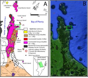
Figure 2. Geological sketch map (A) of the Coromandel Peninsula based on “Edbrooke, S.W. (compiler) 2001: Geology of the Auckland area: scale 1:250,000. Lower Hutt: Institute of Geological & Nuclear Sciences Limited. Institute of Geological & Nuclear Sciences 1:250,000 geological map 3. 74 p. + 1 folded map”. Highways are shown as black polylines. The numbers along the lines refer to the New Zealand Highway system numberings. GoogleEarth Pro satellite image shows the rugged elongated mountainous region of the Coromandel Peninsula (B).
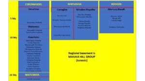
Figure 3. Lithostratigraphical framework of the rock the Coromandel Peninsula after Adams et al. 1994.
The northern Coromandel peninsula is underlain by late Jurassic sedimentary basement rocks (Figs 2 & 3) which can be seen in outcrops on the north-western coast of the peninsula, and on the north-facing coast of the Kuaotunu Peninsula (Fig. 4) (Edbrooke 2001). Subduction related volcanic activity in the Coromandel Volcanic Zone commenced 18 Ma, and progressed southwards between 16 and 5 Ma (Skinner 1993; Adams et al. 1994; Skinner 1995). Between 1.9 and 1.6 Ma subduction volcanism shifted to the Taupo Volcanic Zone where today it forms the beginning of the Hikurangi Subduction Back-Arc Volcanic Chain (Kear 1994; Hayward et al. 2001; Hayward 2017). Within the wider volcanic landscape of the Coromandel (Homer and Moore 1993; Adams et al. 1994), one can find an extensive suite of volcanic rocks including basaltic lava and scoria (Huang et al. 2000); ignimbrites (Malengreau et al. 2000; Briggs et al. 2005; Smith et al. 2006; Booden et al. 2012); andesite lavas and pyroclastic succession (Booden et al. 2010); rhyolitic coherent and pyroclastic rocks(Moore 1983; Briggs and Fulton 1990; Moore 1999; Carter et al. 2003; Moore 2013); various intrusive igneous rock outcrops (Skinner 1975; Garmson 2014); epithermal mineral deposits (Harvey 1997; Christie et al. 2001; Mauk et al. 2011); and various, mostly vent/crater-filling exhumed volcanic breccias. (Thompson and Kermode 1965) Volcanic landscape features include basalt cone erosion remnants, eroded andesitic volcanoes; exposed lava plugs; and dissected, and exhumed (partially covered caldera structures that are gradually re-exposed due to erosion) caldera remnants (Homer and Moore 1993; Malengreau et al. 2000; Hayward 2017). Most of these erosion remnants show near-vent, vent/crater-filling or proximal volcanic successions associated with a great diversity of volcano types ranging from small-volume mafic monogenetic, through intermediate strato-, silicic lava dome, and caldera volcanoes.
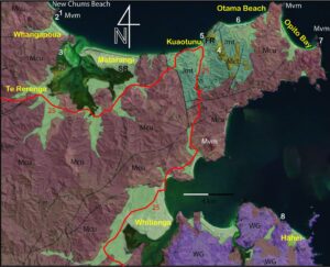
Figure 4. Geological map of the Mercury Bay area after “Edbrooke, S.W. (compiler) 2001: Geology of the Auckland area: scale 1:250,000. Lower Hutt: Institute of Geological & Nuclear Sciences Limited. Institute of Geological & Nuclear Sciences 1:250,000 geological map 3. 74 p. + 1 folded map”. Geological units are overlaid by the satellite image, capturing the relationship between various geological units and the present-day topography. Geological units marked as Mvm - Mercury Basalt (Late Miocene - Pliocene); WG - Whitianga Group (Late Miocene) - Silicic lava flows, domes, ignimbrites; Coromandel Group: Mct - Waitaia Sinter; Mcu – Kuaotunu Subgroup [Miocene] - Andesite, dacite lavas, intrusives and volcaniclastic sedimentary rocks; Basement: Jmt – Manaia Hill Group [Jurassic] in Waipapa Composite Terrain – Massive, medium to coarse-grained sandstone with interbedded siltstone and conglomerate. The map shows the key geosites from west to east proposed as part of a geotrail in the region; 1) Motutu Point; 2) Submerged shore platform of Whangapoua Beach; 3) Estuary near Whangapoua; 4) Waitaia Sinter and epithermal gold region; 5) Manaia Group basement cliffs; 6) Otama Beach; 7) Opito Point pa site; 8) Cathedral Cove. SR – scenic reserve; FR – forest reserve. Small mine signs show former gold-silver mineralisation sites. General bedding symbols show the main attitude of the geological layers of the region. Bold lines show mapped fault lines, while dashed lines refer to inferred fault locations.
Archaeological evidence suggests the arrival of the first humans in New Zealand took place around AD 1200(Anderson 2009), with archaeological dating of sites on the Kuaotunu peninsula demonstrating occupation between 1280 and 1400 (Davidson 2018). Analysis of preserved pollen demonstrates Early Māori occupation on Ahuahu (Great Mercury Island) based on cultivation of the tropical crop taro (Prebble et al. 2019). As Polynesian settlers transitioned from a colonisation phase to a traditional Māori phase (Anderson 2009), Māori occupation and resource use spread north and southwards along the east coast of the Coromandel (Green 1963; Moore 1999). The earliest known stone quarry in New Zealand at Opito on the Kuaotunu Peninsula (Moore 1976), and the visible remains of stone fish traps near Colville (King and Morrison 1993), tell a story of landscape modification and resource use. Archaeological evidence in the form of middens, stone fences, and reworked stone provides evidence of coastal settlement and land-use (Boileau 1980; Moore 1999; Moore 2013; McIvor and Ladefoged 2016), while earthworks and pā (fortified settlement, usually sited on a headland or hill, and recognizable by terracing and other earthworks)sites may be visible and exposed by grazing stock or hidden beneath regenerating fauna.
Abundant natural and geological resources and a settlement pattern shaped by the landscape and its geomorphology meant Māori civilisation on the Coromandel thrived (Davidson 2018), relatively undisturbed, until the19th century. Following from European colonisation, settlers hunger for land came into conflict with Māori determination to protect their lands, while the European world’s need for timber saw exploitation of native kauri (Agathis australis) forests (Halkett and Sale 1986; Orwin 2004), and the search for gold concurrently scarred the landscape (Nolan 1977; Moore and Ritchie 1996). This boom and bust cycle of resource extraction reached its peak in the 19th century, and by the beginning of the 20th century, farming, fishing, and forestry (both native and plantation exotics) were the main economic activities up until the 1980’s (Hawke 1981) when regular annual holidays gave birth to the tourist culture and a new boom completely transformed the peninsula (CPRP 1986).
The Coromandel peninsula in the 1950s was described as being more akin to an island, roads largely unsealed, and overnight accommodation under canvas tents (King and Morrison 1993). Travel around the peninsula required determination and time, with the bush regions accessible only to determined trampers and experienced outdoors recreationists (Reed 1952; Grayland and Grayland 1965). The settlement of Whangamata was described as “no more than a cluster of fibrolite baches behind the dunes” (King & Morrison, 1993, p. 4). In contrast, a recent survey count of cellular phone data by the Thames Coromandel District Council (TCDC 2017), showed half a million unique visitors located in the Coromandel during the two weeks around Christmas and New Year. Destination Coromandel in 2015 in its report Beyond 2025 (Destination 2015) expresses a vision of The Coromandel as New Zealand’s “must-visit destination”. An “exemplary example” of an iconic tourist destination, formerly a relatively unknown and inaccessible coastal location on private farmland (King & Morrison 1993), and now one of the most visited locations in the country, is Cathedral Cove (http://counterreports.doc.govt.nz/var/100102439.html).
Cathedral Cove, an iconic tourist site under pressure.
Cathedral Cove (Te Whanganui-A-Hei) is located north of the village of Hahei (See: https://www.hahei.co.nz/index.html) on the shore of Mercury Bay on the east coast of the Coromandel Peninsula (Fig. 4). Originally part of an extensive block of coastal farmland, it was preserved as a public reserve during subdivision in the 1970s (King & Morrison 1993). Once a remote beach, it is now considered a top “jewel” in the tourism sector’s crown. Managed by the Department of Conservation (See: https://www.doc.govt.nz/our-work/), at least 282,000 visitors (estimates based on the time period between Feb 2018 to Jan 2019) annually walk through the iconic arch eroded into the rhyolitic ignimbrite bluffs (https://www.doc.govt.nz/globalassets/documents/about-doc/role/visitor-research/visitor-sites-data-2018-2019.pdf). In the 2005 film of The Lion, the Witch and The Wardrobe [https://www.imdb.com/title/tt0363771/], the Pevensie children take their first steps into Narnia against a backdrop of this iconic feature, affording this geological feature global recognition. Today only a few locals stroll the cove, there are no international tourists. While we acknowledge the global disruption caused by the Covid-19 pandemic, this pause in human activity gives us cause to reflect and consider management of a growing tourism footprint and economic reliance on singular landscapes. We recognise research undertaken in this paper as an opportunity to reassess a tourism model based on short stays and high-volume numbers (TCDC 2017).
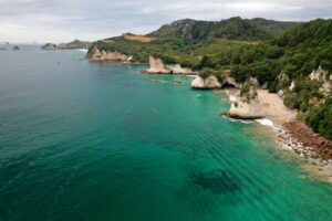
Figure 5. Cathedral Cove coastal outcrops, a scenic site with high geoheritage value of exposed ignimbrite rocks.
Geologically Cathedral Cove (Fig. 5) displays typical characteristics of coastal ignimbrite features formed by volcanic deposition and subsequent erosion (Hayward, 2017). Layers of rhyolitic flows interbedded with tephras and pyroclastic ignimbrites are exposed in coastal cliffs in the region. Contact boundaries between deposits of Minden Rhyolite Subgroup, comprising lithoidal and spherulitic rhyolites; and Coroglen Subgroup, which includes ignimbrite, pumice breccia and pumiceous sediments, are exposed in the coastal area (Moore, 1983). Volcanic deposits were erupted from the Whitianga Volcanic Centre (Malengreau et al. 2000) in the late Miocene age (Fig. 3), with an estimated age of Bluff Rhyolite dome of 7.8 Ma (Moore 1983).
The arch which gives Cathedral Cove its name is a result of the process of preferential erosion along a fracture in the ignimbrite (Fig. 5). Over time caves eroded along rock fractures link to form an archway. Ultimately the arch roof will collapse leaving a rock stack offshore and over thousands of years the headland will be completely eroded away (Homer and Moore 1993).
Cathedral Cove sits within a rich geological, cultural, and ecological landscape. Views offshore look out to Ahuahu (Great Mercury Island), the earliest site of Māori occupation in the region. (Prebble et al. 2019) On the headland above Cathedral Cove are the preserved earthworks of Mautohe Pā (Homer and Moore, 1993). Small islets offshore are formed by the eroded remnants of rhyolite domes (Moore, 1983; Homer and Moore, 1993; Skinner, 1993), and also feature evidence of pre-European habitation (Moore, 1999). Mercury Bay takes its name from Captain Cook’s stopover here to observe the transit of Venus by Mercury, and the area is significant as the site of first contact between the indigenous people and European explorers (King and Morrison 1993; Williams and Williams 1994). Since 1992 the coastal waters around Cathedral Cove have been protected as the Te Whanganui-A-Hei Marine Reserve (See: Mercurybay.co.nz).
Visitor numbers had been steadily increasing during the first decade of the 2000s to the point where a back-country track was not servicing the requirements. The track was upgraded to a tarmac sealed path and toilets were built on the beach to minimise the damage. For the last five years a track counter located at the final approach to the beach (DOC 2000) recorded an estimated ~300,000 visits to the cove (http://counterreports.doc.govt.nz/var/100102439.html). In addition to numbers recorded by the counter, the area is serviced by commercial sea taxis, and other commercial ventures (thecoromandel.com, 2020), private pleasure craft, and individuals entering and exiting through other parts of the reserve. Work is under way to capture this and further analyse this data, with current estimates as high as 500,000 visitors and up to 6,000 visitors on the track at peak times (Personal communication, Twemlow 2020) Health and safety assessments of the arch are undertaken on a regular basis. The public have been restricted from climbing over the feature and are only permitted to move around the foreshore and formed tracks. Infrastructure and the wider area are maintained by Department of Conservation Rangers (Personal communication, Twemlow 2020). In recognition of the need for effective interpretation material (Migon and Pijet-Migon 2017; Bruno and Wallace 2019) an upgrade of interpretative information is currently being undertaken (Personal communication, Twemlow 2020).
Ghosts of Old Volcanoes Geoheritage Trail: Whangapoua to Opito Bay, Coromandel
Our initial research proposal is for the first stage of development of a geoheritage trail incorporating the area from Whangapoua to Opito Bay, Kuaotunu Peninsula, East Coast of the Coromandel Peninsula (Figs 2 & 4). A geoheritage trail allows for a journey through the landscape, linked by sites that demonstrate the geological, cultural, and environmental history of the land (GSA 2017) . In this case, a common theme is the volcanic nature of the landscape, an important force in shaping the Coromandel Peninsula (Homer and Moore 1993; Hayward 2017). Human history in the landscape is demonstrated by the presence of historic pā (Green 1963), and more recent gold-mining sites(Christie et al. 2001), while the area also contains ecologically significant features such as wetlands (Byrami et al. 2002) and coastal dune formations (Hilton et al. 2000). Offshore significant features are volcanic islands (Skinner 1995) set in waters popular for diving and recreation, providing examples of marine volcanic features and associated ecology. A geographic area of research and potential development is defined, and we demonstrate that this area has significant potential for being the basis of a geoheritage trail, thereby providing tourist, education, and community engagement opportunities.
The main township in the study area is Kuaotunu (Fig. 4), notable for a highly engaged community in environmental management and conservation and restoration initiatives. Focus has predominantly been on ecological initiatives (See: https://www.kuaotunu.nz/community-plan/), however integrating that with geoheritage initiatives adds another layer to the multi-faceted stories of the land, which can then be shared by the community to the mutual benefit of both visitors and residents. For example, highlighting the establishment of Kuaotunu as a goldmining and kaurilogging settlement (Simpson 1955) with numerous landscape features and modifications telling the story of the harsh and sometimes brutal occupation of extracting gold from the epithermal mineral deposits (Eldred-Grigg 2011); and felling gigantic kauri trees by hand in remote and rugged bushland(Halkett and Sale 1986; Orwin 2004) . Establishing a regional geoheritage trail can strengthen the relationship between the community and the land, and rather than a fleeting passive tourist experience for visitors, the tourist experience takes the form of establishing a relationship with the land and its people.
To date the area has several walkways and reserves under several different ownership and management structures. Incorporating already defined walkways (TCDC 2019) and reserves (e.g. Otama Dunes Wetland Reserve (https://www.otama.org.nz/)) into the geoheritage trail (without necessarily altering current management structures) would provide an additional level of opportunity for drawing visitors to this area for a meaningful and memorable experience. Additionally, establishment of the geoheritage trail would provide opportunities for community engagement and education, promotion and training for tourism ventures, and opportunities to draw a community together through a venture that celebrates the land on which those communities are based. Providing educational and interpretive material linking sites and communities together under the framework of a local geoheritage trail would promote a strong sense of identity for the region, building on the proximity to already well known and popular visitor destinations. It is important here to note that interpretation is not the same as information. According to Bruno and Wallace (2019) “Effective interpretation panels go far beyond conveying information: they are highly engaging, instill passion, and inspire visitors to engage in environmental stewardship”. Drawing on the history of interpretation in American National Parks, Tilden (1977) states that interpretation is the “work of revealing, to such visitors as desire the service, something of the beauty and wonder, the inspiration and spiritual meaning that lie behind what the visitor can with his senses perceive” (Tilden 1977). So rather than series of independent stops on a trail, the geoheritage trail becomes a journey through unfolding the story of the land and people through engagement and conversation with participants (Migon and Pijet-Migon 2017).
Description of Study Area and Proposed Geoheritage Trail
The proposed study area extends from Whangapoua in the north, incorporates the Kuaotunu Peninsula and extends as far south as Cathedral Cove in Mercury Bay., Settlements in the area include townships of Matarangi, Kuaotunu and Whitianga (Fig. 4). A diversity of landforms is accessible in the area, from the remnants of ancient volcanic activity to more recent estuarine and coastal landforms (Homer and Moore 1993; Hayward 2017). Figure 4 shows the proposed study area on the Coromandel Peninsula, and several examples of sites considered suitable for further in depth assessment and research. The geoheritage trail follows the highway as shown in Figure 2, however, access to some sites may require walking and varying degrees of fitness levels, while other sites are readily accessible from the road. The majority of the geosites are the result of long extinct volcanic processes and reflect geoheritage values e of the Coromandel Peninsula. We identified eight geosites that broadly represent the volcanic history, landscape evolution and coastal processes typical in the broader Coromandel Peninsula geology; 1) Motutu Point; 2) Submerged shore platform of Whangapoua Beach; 3) Estuary near Whangapoua; 4) Waitaia Sinter and epithermal gold region; 5) Manaia Group basement cliffs; 6) Otama Beach; 7) Opito Point pa site; 8) Cathedral Cove. Cathedral Cove has already been introduced as a local geotouristic hotspot and flagship geosite of rhyolitic volcanism in the Coromandel Peninsula. The submerged shore platform of Whangapoua Beach (Fig. 6A) and the estuary near Whangapoua (Fig. 6B) provide examples of coastal morphological elements of the region, with mostly aesthetic values. The Waitaia Sinter and epithermal gold region have strong geocultural aspects to the gold mining history of the region based on volcanic-hosted epithermal gold mineralisation (Fig. 6C), while the Manaia Group basement cliffs provide a view to visitors of basement rocks underlying the more recent volcanism taking place since the Miocene (Fig. 6D). We have not provided further details on these sites as they are not directly relevant to the volcanic geoheritage of the region, however they do provide a conveniently located geological framework demonstrating the deeper geological story behind New Zealand as part of Gondwana. In the following section, we provide more detailed description of three example sites with their features demonstrating strong links to volcanic processes. These sites were selected for detailed description as they have the strongest and most explicit geological features with additional archaeological and costal erosional features. We use the following sites to demonstrate the combined influences of a volcanic landscape subject to geomorphic processes that made this area attractive to the earliest inhabitants of New Zealand (Phillips 2000).
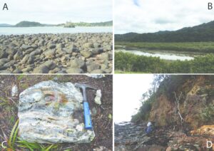
Figure 6.
A) Submerged shore platform of Whangapoua Beach. Large boulders of basaltic rocks from the Mercury Basalt exposed are exposed at low tide, forming a broad shoreline. In the middle view a small islet exposes radially jointed basalts with well-developed columnar jointing.
B) Typical estuary near Whangapoua provides important ecological habitats
C) Sinter deposits of the Waitaia Sinter above Kuaotunu township.
D) Basement greywacke cliffs of the Manaia Group form a strongly weathered and colourful set of rocks along the coastline between Kuaotunu and Otama Beaches.
Motutu Point
Motutu Point (Fig. 4) is formed from the eroded remnants of a volcano that erupted between 8 and 9 million years ago (Skinner 1995). As the outer flanks of the volcano have been eroded, spectacular outcrops of vertical basalt columns have been exposed (Figs 7A & B) as well as proximal pyroclastic successions of the former tuff ring and scoria cone (Fig. 7C). The basalt columns are similar in appearance to famous outcrops such as columnar jointed basaltic rocks of The Giant’s Causeway in Ireland (Crawford and Black 2012). While columnar jointing is a common phenomenon within thick basaltic lava flows as the result of volume reduction of the cooling pile of lava (Hetenyi et al. 2012), spectacular examples that are accessible are not as common, and surprisingly rare in New Zealand. In addition, the slopes of the headland were the site of a Māori pā with well-preserved earthworks still visible (Homer and Moore 1993). The lookout above the rocks provides views over a drowned river marine estuary, and the coast beyond following the route of the geoheritage trail. Such estuaries provide an exceptional example for visitors of continuously changing coastal geosystems where sediment input, marine erosion and tidal effects all interact in the formation of a finely balanced ecosystem. (Brocx and Semeniuk 2009). Geoheritage aspects of such estuary systems have been explored in some locations and incorporated into various geoeducation and geoconservations works elsewhere (Brocx and Semeniuk 2011; Erskine 2013; Lokier 2013). From here a track through native Pohutukawa (Metrosideros exelsa) and Nikau (Rhopalostylis sapida) forest provides access to New Chums Beach (Fig. 7D), one of the least developed beaches in this area, featuring a backdrop of native coastal bush and white silica-rich sands (TCDC 2017).
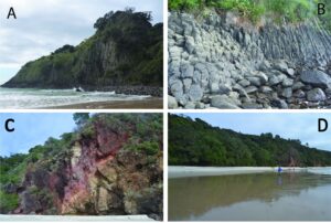
Figure 7.
A) Motutu Point, between Whangapoua Beach and New Chums Beach exposes a spectacular set of columnar jointed basalt, part of the Mercury Basalts (view from the New Chums Beach).
B) Columnar jointed basalt in close view (view from Whangapoua Beach)
C) Proximal pyroclastic rocks near Motutu Point showing faulted and thermally altered (reddish) pyroclastic rocks.
D) New Chums beach with high aesthetic value.
Otama Beach
Otama beach (Fig. 4) features an active coastal dune system providing a readily accessible and well-preserved example of geomorphological processes active in the coastal foreshore dune (Fig. 8A). The dunes and the beach are composed of white sand derived from underlying ignimbrite sheets eroded since the Miocene (Fig. 8A). Coastal dune networks are a dynamic and ever changing geoenvironment along the narrow interface between terrestrial and marine environments (Hilton et al. 2000). Such active systems provide a unique opportunity to see the way dunes move, migrate and evolve and how the entire system is affected by tidal waves, wave actions, contour current movements, climatic changes, all recorded in the stratigraphy of such dune systems (Skinner 1993). Coastal settings often provide a geological record displaying cross-bedded sandstones; and a modern dune system may provide clues to understanding the transformation of loose sand to sandstone rocks through rock-forming processes over millions of years (Best et al. 2001; Wardell-Johnson et al. 2015; da Silva and Shulmeister 2016; Bradley and Venditti 2017). This area also includes native dune plant associations (Graeme 2000), adapted to grow in sand, and playing a vital role in dune stabilisation. The beach and dunes are composed of white silica rich sand, derived from weathering and erosion of silicic volcanic rocks underlying much of the regional landscape. This site demonstrates the influence of volcanic chemistry of source rocks on the types of sediments forming beaches and dunes in the area. Undisturbed active dune formations and their native plant formations are relatively rare because of human settlement in New Zealand (Hilton et al., 2000), so this pristine coastal dune system provides an ideal demonstration of community engagement with conservation initiatives.
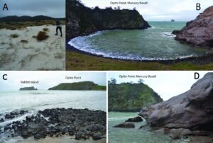
Figure 8.
A) Otama Beach white sand dunes composed of quartz and pumice derived from ignimbrite sheets.
B) Opito Point with a pa site sitting on a columnar jointed basalt inferred to be a vent site and formed by Mercury Basalts
C) Mercury Basalt forms steep sided cliffs and islets along the Otama Beach where erosion remnants of basaltic monogenetic volcanoes are preserved. In these preserved vents radially arranged columnar jointing is prominent. The islet in the photo (Rabbit Island) and the Opito Point (with a pa site) headland both composed of columnar jointed basalts and inferred to be vent sites just like the location from where the photo was taken. In foreground, pentagonal and hexagonal cuts of columnar jointed basalt are exposed.
D) Andesitic volcanic breccias with strong thermal alteration forming coastal cliffs as a remnant of a proximal block and ash flow deposits of eroded stratovolcanoes (Mahinapua Andesite). Note the contrasting colour of the Opito Point composed of Mercury Basalt.
Archaeological sites on the Kuaotunu Peninsula and Mercury Bay area are significant in the history of New Zealand research, as it was through excavations in this area and others in the country that the archaeologist Jack Golson (Golson 1959a; 1959b) developed his theory that Māori society in New Zealand went through several phases. Shaped by changes in the resource base and societal structure, these are now generally accepted as the ‘archaic’ or ‘moa hunter’(Anderson 1983; Davidson 2018); ‘transitional’ (Jones 2007) (Jones 2007); and ‘classical’ periods (Jones 2007; Anderson 2009).
Opito Point pā site
Opito Point pā site is located on headland formed from erosion resistant rock (Figs 8B & C), providing an excellent example of a medium size headland pā with commanding views of surrounding land and sea, and protection afforded by steep cliff faces. A staircase track from the white silica sand beach provides access to the pā site where pre-European earthworks include defensive ditches, rua kūmara (kumara/sweet potato pits) and terraces (DOC 2018). In addition, views include the Opito Bay, the offshore Mercury Islands, and Needle Rock, all remnants of volcanic rocks formed through landscape building effusive and explosive volcanic processes that have shaped this landscape (Skinner 1995; Gavalas, 2008) . Where rock does not form the coastline, readily accessible white silica sand beaches with safe swimming conditions are a popular attraction, interspersed with coastal dune formations, and estuarine harbours and wetlands. The wider landscape in this area also features Mount Tahunga, an important pā site and location of a pre-European quarry where the inhabitants used the Tahunga Basalt to make tools. This unique fine-grained volcanic basalt (Moore 1976) was considered so valuable for its purpose that it was widely traded throughout the country, with examples found at archaeological sites throughout New Zealand, reinforcing the importance of this area as a centre of trade networks (Jones 1987; 2007). Strongly weathered, commonly reddish andesite breccia form coastal cliffs as erosion remnants of andesitic medium-sized stratovolcanoes, part of the Mahinapua Andesite (Fig. 8D).
Conclusion
The sites discussed in this report are intended only as a representative example from the proposed study area, which we believe shows significant potential for an in-depth and on-ground assessment of further sites suitable for incorporation into the geoheritage trail. The study area is accessible by road, ranging from sealed highway to metal roads, with some sites accessible by foot only. In some cases, sites may only be accessible by boat, or an entirely different view of the feature may be provided by viewing from sea. Given the popularity of the Coromandel as a holiday destination, there is a ready market of visitors to whom the concept of a geoheritage trail may appeal. This trail and the framework of development and implementation seeks to engage with all types of visitors; however, it will also serve a valuable purpose in engaging the local community in learning, training, and tourism development. As a self-guided experience with a readily accessible source of interpretation it may appeal to travelers following a self-guided itinerary, however, it would also be suitable for a guided experience, thereby providing opportunities for locals, educators, and tourist operators. In addition to the geography and geology of the area, a focus on cultural and environmental history allows for cross-disciplinary collaboration and facilitates an integrated environmental management approach to the area. This in turn promotes a holistic visitor experience and a more leisurely journey.
Acknowledgments
The proposed title of the geoheritage trail is influenced by the book ‘Vanishing Volcanoes. A guide to the landforms and rock formations of the Coromandel Peninsula’, by Philip Moore with Lloyd Homer, published in 1992, and in principle describing a Coromandel geotrail. We wish to acknowledge extensive work by Philip Moore in the fields of geology, archaeology, and human history in the Coromandel over the previous decades, providing a foundation and inspiration for further research and developments into the future. We would also like to acknowledge the support of the Department of Conservation Whitianga District Office. Support from the Volcanic Risk Solutions research group at Massey University is greatly appreciated.