Introduction
Geoconservation in Latin America is fundamental to preserving the rich geological and scenic diversity of the region. With a varied geology ranging from imposing mountain ranges to extensive plains, Latin America hosts a wide array of unique geological resources (Mantesso-Neto 2010). Some countries have made notable progress in this regard, such as Brazil, which boasts the first Geopark in the Americas and the Southern Hemisphere: Geopark Araripe. This Geopark comprises nine geosites of significance in geological, paleontological, historical, cultural, ecological, scientific, and economic realms. Brazil also features other Geoparks, including Caçapava UNESCO Global Geopark, Quarta Colônia UNESCO Global Geopark, Seridó UNESCO Global Geopark, and Southern Canyons Pathways UNESCO Global Geopark (UNESCO 2016).
In Argentina, there are diverse places of interest, such as the Bryn Gwyn Geopark in Trelew (Chubut), which has already submitted its candidacy to UNESCO and features both a paleontological and botanical tour. Additionally, there is the Divisadero Largo Park in Mendoza, known for its diverse biodiversity and significant cultural heritage (Mantesso-Neto 2010). There are also highly relevant works, such as Medina (2012), who proposes methodologies for the inventory and quantification of geosites that could be applied at the national level.
Similarly, Chile has the Kütralkura Geopark, designated as a UNESCO Global Geopark in 2019. However, authors such as Benado et al (2019) consider geoconservation in Chile to be still in its early stages, attributed to limited collaboration among institutions currently undertaking initiatives in this field and restricted knowledge in the academic and professional spheres of Earth sciences regarding what aspects to conserve and how to do so.
The appreciation of Paraguay's geological heritage began just a decade ago with a focus on the geoconservation of sites of exceptional geological importance. An example of this is the proposal of the calcareous caverns located in the Department of Concepción, to the north of the Eastern Region of the country, as a geosite. These caverns feature stalactites, stalagmites, and dissolution structures, representing various karstic processes. The limestones deposited in the Ediacaran period belong to the Itapucumí Group (Paniagua et al. 2013; Gadea & Benitez 2018).
Another example, mentioned by Golin et al. (2013), comprises the sandstone outcrops of the Asunción Group with columnar joints (more frequent in basalts) occurring along a tectonic structure (Asunción Rift). These outcrops were formed by magmatic events similar to those affecting sedimentary rocks, leading to hydrothermalism and subsequent jointing in pentagonal and hexagonal prisms—a rarity in geology.
It is also noteworthy that in the municipality of Itauguá, there are outcrops of fossiliferous shales. Fossil invertebrates from these shales are a Llandoverian marine biota, featuring unique genera and species. This area shows the Vargas Peña Formation of the Itacurubí Group, of Silurian age, and deserves more attention for geoconservation efforts (Paniagua 2014; Espínola & Salinas 2022).
Some works also highlight the geomorphological features of landscapes, primarily as a geotourism resource, such as the granite corestones of the Caapucú Suite in the town of Yaguareté Cua, located in the Precambrian zone to the south of the eastern region of the country. These corestones demonstrate processes of deep weathering and subsequent denudation from the Upper Mesozoic to the Lower Cenozoic (Colman et al. 2019), leaving behind cores of granitic rocks. Other notable geomorphological features are the inselbergs or hills, remnants of ancient surfaces or paleo-surfaces with high scenic value. They stand out as exceptional landscapes with steep sides and flat tops, represented by Jurassic aeolian sandstones of the Misiones Formation located northeast of the Eastern region of the country (Sarubbi et al. 2019), but they can also be found in other sedimentary rocks of different ages.
Some local authors have made efforts to inventory the geological and geomorphological heritage, such as Gadea & Benitez (2018), who presented a list of 106 geosites of geotourism interest based on papers. These geosites are located with coordinates by departments, and their geological characteristics group them into the following categories: cavern, paleontology, folding, hydrology, geomorphology, landscape, stratigraphy, mining history, monadnock, tectonics, geoform, paleobotany, columnar sandstones, ethnography, erosion, ichnology, erratic blocks, petrology, Precambrian rocks, dolmen cave, igneous intrusion, volcanic stock, annular complex, landscape volcano, hydrogeology, islet history, glacigenic rocks, paleodunes, cenote landscape, columnar basalts. While this initiative is important, both qualitative and quantitative inventory methodologies should be followed to determine the potential of geosites, geomorphosites, geodiversity sites, etc. Salinas et al. (2021) presented evaluations of the scientific value of two geosites in the metropolitan area of the city of Asunción. These evaluations considered their representativeness, integrity, rarity, and scientific knowledge of the Cerro Koi and Cerro Ñemby sites.
Finally, papers have been prepared about guided tours to geological sites known by university and primary-secondary teachers as support and consolidation of geological knowledge about processes that occurred over millions of years. These field classes not only enhance the learning of concepts but also help assess georesources for their geoscientific and geoeducational importance (López et al. 2021).
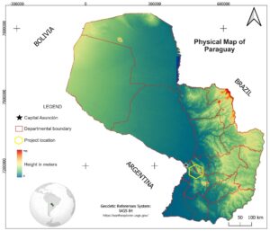
Figure 1. Physical map of Paraguay. Source: https://earthexplorer.usgs.gov/
Geographical and Geological Setting
Being a country without a coastline, Paraguay is bordered to the north by Bolivia, northeast by Brazil, and to the southwest by Argentina. It has a surface area of 406,752 km² and a projected population of 7,554,796 people for 2023 (INE 2023). The main geographical characteristic of Paraguay is being divided by a river of the same name into two regions with very different climates and topography. The Western Region or Chaco is formed by floodplains to the south and scrubland plains with a semi-arid climate to the north. On the other hand, the Eastern Region is characterized by gentle undulations, a subtropical climate, and abundant rainfall, making it more conducive to the country's agricultural and industrial activities. This region concentrates the majority of the population, approximately 97% (INE 2023).
Paraguay is characterized by a wide variety of geological features that contribute to its diverse geomorphology, as mentioned earlier. This geodiversity has been described in numerous geological studies that began in the mid-twentieth century, primarily focusing on petrology, mineralogy, structural geology, and, in subsequent decades, geotectonics, mining potential, and the scarcely explored geological resources. The eastern region boasts the greatest geological diversity in the country, hosting two Precambrian areas. The first, located to the north, is associated with the southernmost detachment of the Amazonian Craton, while the second area corresponds to the northernmost detachment of the Río de la Plata Craton (Granja Dorilêo Leite et al. 2018). In addition to these Precambrian areas, the region also features outcrops of sedimentary and igneous rocks spanning from the Cambrian to the Neogene. These rocks represent various environments, including marine transgressions and regressions, glaciations, sandy deserts, fluvial environments, etc. Moreover, the region exhibits different magmatisms and volcanisms, ranging from granitic and basaltic to alkaline traps (Fig. 2).
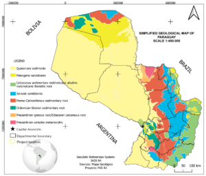
Figure 2. Simplified Geological Map of Paraguay. Modified from Proyecto PAR 83
Ñandeyvytykuera Geopark Project
Background
There is currently a geopark proposal in Paraguay that was initiated in 2017 through the Environmental Management Committee of the Natural Monuments of Cerro Koi and Chorori, located 30 km from Asunción. This committee consisted of institutions such as the Ministry of the Environment and Sustainable Development (MADES), the National Secretariat of Tourism (SENATUR), and the Municipality of Areguá. Initially, the idea was to nominate the natural monument for its distinctive geological formations of sandstones with columnar joints. However, following participation in international conferences on the subject1,2 and a technical visit by representatives of the United Nations Educational, Scientific and Cultural Organization (UNESCO) in mid-2018, it was outlined and defined that there should be additional proposals for geological sites to apply for recognition3 as UNESCO Global Geoparks (UGGp).
In accordance with UNESCO's guidelines, the first Geopark Management Committee (CGG) was formed, comprising the Faculty of Exact and Natural Sciences of the National University of Asunción (FACEN-UNA), SENATUR, MADES, the Government of the Central Department (GDC), and the Organized Civil Society of the Municipality of Areguá and San Bernardino (Fig. 3). The committee's responsibility is to develop the first national geopark called 'Geoparque Ñandeyvytykuera' (Our Hills in the Guarani language) to become part of the UGGp (López & Salinas 2022). The CGG is tasked with identifying geological sites in the Eastern Region of Paraguay within the Central, Cordillera, and Paraguarí departments. Numerous geological sites have been located whose geological formations align with the regulations recommended by UNESCO.
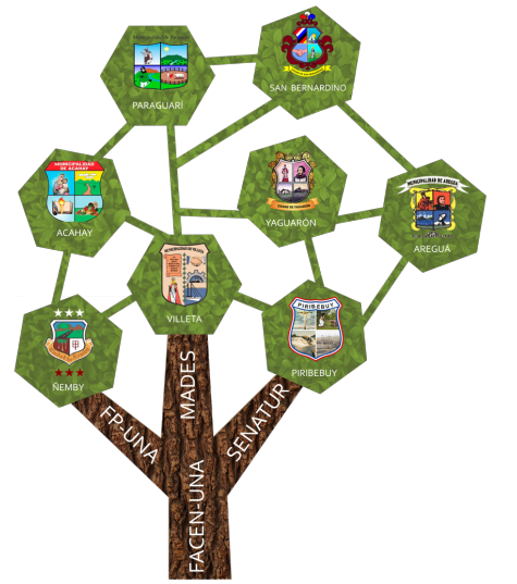
Figure 3. Organizational structure of the Geopark Management Committee (CGG) and its collaboration with representative municipalities
1ABC color (2017) El Cerro Koi es candidato a ser declarado geoparque por la UNESCO. Recuperate: https://www.abc.com.py/edicion-impresa/interior/el-cerro-ki-es-candidato-a-ser-declarado-geoparque-por-la-unesco-1650934.html
2IP - Agencia de Información Paraguaya (2017) Cerro Kôi postulará como candidato a Geoparque de la Unesco. https://www.ip.gov.py/ip/cerro-koi-postulara-como-candidato-a-geoparque-de-la-unesco/
3Última Hora - UH (2018) Pretenden que sitios geológicos estén en programa de Unesco https://www.ultimahora.com/pretenden-que-sitios-geologicos-esten-programa-unesco-n1149482
The CGG initiated dialogues with various community stakeholders and municipal authorities to discuss the proposal for establishing a Geopark in the Central, Cordillera, and Paraguarí Departments. The discussions incorporated diverse themes, including geology, biology, human ecology, tourism, history, culture, tradition, dances, gastronomy, art, and music (Fig. 4), aiming to foster community participation across the entire geopark territory.
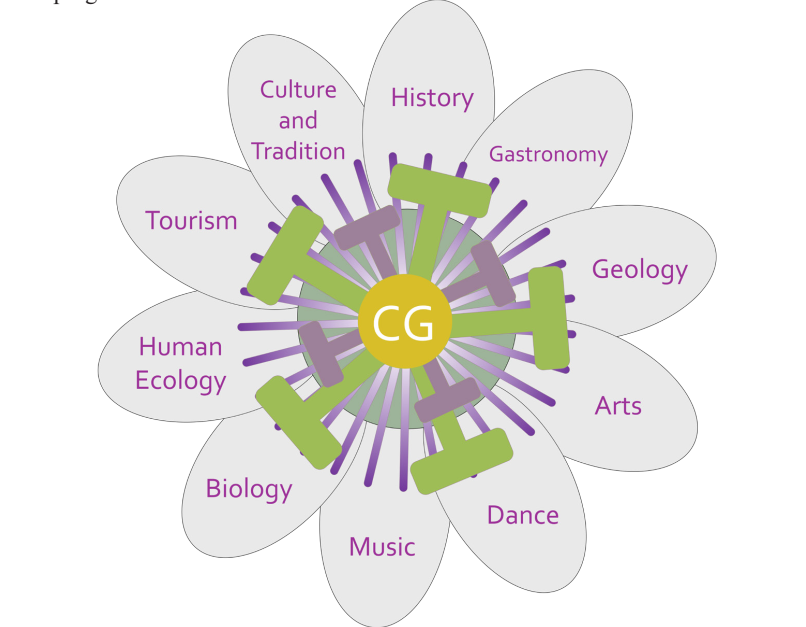
Figure 4. Main themes of the geopark project in Paraguay, represented in the petals of the national flower of the country, the Mburukuja (Guarani language) (Passiflora caerulea).
To foster sustainable development in diverse communities across the country, the Geopark and Biocultural Heritage Research Center (NIGPBC in Spanish) has been established at FACEN-UNA. This initiative endeavors to launch a new research direction led by faculty and students, with the primary goal of emphasizing the value of geological heritage as an opportunity for community growth (López & Salinas 2022). The NIGPBC has entered into a technical-scientific cooperation agreement with the Tourism, Hospitality, and Gastronomy Research Group (GITHG in Spanish) at the Polytechnic Faculty (FP-UNA in Spanish), both affiliated with the National University of Asunción. This collaboration aims to conduct activities to identify and catalog the geological and tourist potential of the territory to fortify the geopark project (Balbuena 2022). Furthermore, efforts are being made to establish agreements with the Faculty of Agrarian Sciences (FCA-UNA in Spanish), particularly with the Human Ecology Engineering program, to enhance and unite forces for the development of local communities at each site. However, one of the primary challenges of this proposal is securing funding for research on natural and geological heritage, which can serve as a strategy to promote sustainable development at the local level.
The NIGPB engages in various activities to promote the geoconservation of the geological heritage of the country and the geopark territory. These activities include the training of park rangers for the proposed Cerro Koi geosite (Salinas 2021), discussions about clay with potters from the municipality of Areguá, and more. Although these activities were affected during the Covid-19 pandemic, efforts were made to promote educational videos, as well as local, national, and international virtual events and meetings (Salinas & Lopez 2022).
Geological Setting of the Geopark Project
The territory of the geopark project encompasses various geological features, including alignments, rift zones, igneous intrusions, dips of sedimentary strata, and outcrops of Precambrian rocks, among others. Across the three departmental divisions covered by the project; in the Central Department, there are outcrops of Paleocene sedimentary rocks, predominantly sandstones. These rocks were influenced by alkaline ultramafic volcanism during the Eocene, with some forming columnar joint structures in sandstones.
The Cordillera Department features Lower Paleozoic sedimentary rocks, primarily conglomerates, sandstones, and shales, which overlie Precambrian granitic bodies. In the Paraguarí Department, a diverse range of rocks from various origins and ages can be found. These include Paleozoic sedimentary rocks, Cretaceous conglomerates, and Upper Proterozoic metamorphic rocks.
Inventory of Geological Sites
To emphasize the value of the natural heritage linked to the geosites within the Geoparque Ñandeyvytykuera territory, a methodology based on the proposals of Brilha (2016) and Martínez (2010) was adopted. This methodology was tailored to the specific characteristics of the study area, aligning with the UGGp guidelines. The process involved multiple stages. Initially, relevant bibliographic material was gathered, focusing on the geological elements present in the study areas, as well as the cultural and social aspects associated with the region. Utilizing this information, areas of scientific, educational, and tourist interest were identified and acknowledged. These areas, distinguished by their unique characteristics, were classified as geosites and/or geodiversity sites. In total, 22 locations were selected, situated across various districts in the departments of Central, Cordillera, and Paraguarí (Fig. 5).
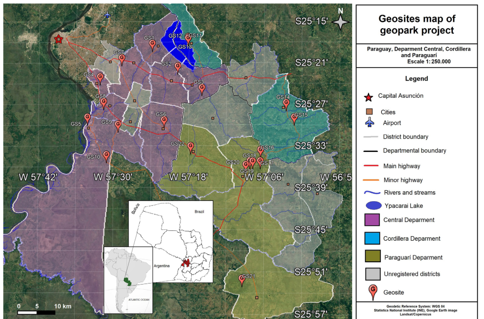
Figure 5. Location map of inventoried geosites of Geoparque Ñandeyvytykuera Project Territory.
In the selected places of interest, a qualitative assessment of their geological elements in terms of their scientific value was conducted through fieldwork for the identification and qualitative evaluation of each geosite on the list of potential geosites. This assessment was based on the following four criteria, taking into account their scientific, educational, and tourism value, as well as fragility and vulnerability (Brilha 2016):
Scientific Value:
(1) representativeness is how a geosite exposes or explains geological processes;
(2) integrity refers to the conservation conditions of the site;
(3) rarity if it is a unique geosite within a certain area;
(4) scientific knowledge the scientific literature that exists on the geosite.
Similarly, the qualitative assessment of potential geodiversity sites is also based on four criteria, one for their educational potential and the other for their tourist potential (Brilha, 2016):
Educational Value:
(1) didactic potential;
(2) geological diversity;
(3) accessibility;
(4) security.
Tourism Value:
(1) scenery;
(2) interpretive potential;
(3) accessibility;
(4) security.
-For both the geosites and the geodiversity sites, their Fragility and Vulnerability were determined:
(1) deterioration;
(2) fragility;
(3) anthropogenic vulnerability;
(4) proximity to areas/activities with potential to cause degradation;
(5) protection;
(6) urgency of protection.
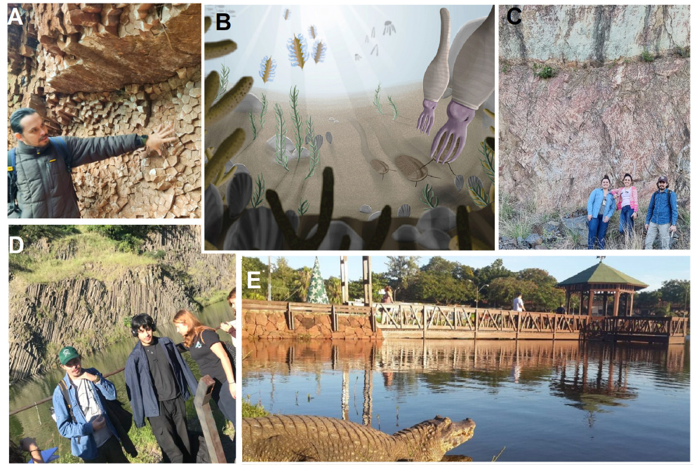
Figure 6. Inventory of Geosites/Geodiversity sites (GS) of the Central Department: A) GS1 Columnar disjunction of sandstones, B) GS2 Paleoecological reconstruction of the Llandoverian fauna (Uriz et al. 2018), C) GS3 Ypacaraí Quarry, wall of rhyolitic rocks, D) GS4 Ñemby Hill, showing Nephelinites with a columnar arrangement, E) GS11 Itá Lagoon with a caiman out of the water (By UH).
Inventory of Geosites/Geodiversity sites (GS) of the Central Department
GS1 - Columnar sandstones of Cerro Koĩ, a geological rarity (Fig. 6A)
Located in the district of Areguá, within the Natural Monuments Cerro Koĩ and Chororĩ, protected by Law No. 179 of the year 1993, it is located at coordinates 25°19'29.08"S; 57°23'50.05"W; Elevation: 192 m. They are sandstone outcrops with polygonal columnar structures that were formed due to contraction by heating and subsequent cooling of poorly consolidated sediments of fluvial origin of the Asunción Group (Génez 2014), due to contact with dike-shaped nephelinitic igneous intrusions of the Alkaline Province of Asunción in the Paleocene (Velázquez et al. 2008).
GS 2 - Fossiliferous Shales of Itauguá, a Silurian sea (Fig. 6B)
Located in the district of Itauguá, at coordinates 25°22'43.14"S and 57°19'46.13"W, with a height of 112 m, it presents outcrops of fossiliferous shales belonging to the Vargas Peña Formation of the Itacurubí Group, dating from the Llandoverian (Lower Silurian), and represents marine paleoenvironments. They present a wide variety of species and genera of invertebrates, such as graptolites, trilobites, bivalves, gastropods, brachiopods and hyolithids, among others (Uriz et al. 2018), with locally described species such as the trilobites Calymene harringtoni, Dalmanites ypacarayensis, and Guaranites paraguayensis, the brachiopod Eocoelia paraguayensis, and the hyolithid Hyolithe guaraniensis (Tortello et al. 2012; Uriz et al. 2018).
GS3 - Ypacaraí Quarry, Cambrian volcanic rocks (Fig. 6C)
Located in the district of Ypacaraí, at coordinates 25°25'48.71"S and 57°15'55.63"W and an elevation of 84 m above sea level. It presents mainly acidic volcanic to subvolcanic igneous rocks, belonging to the Caapucú Magmatic Suite, and dating from the Lower Cambrian (Dionisi et al. 1998). The rocks exhibit phenocrysts of feldspar, quartz, and lithic fragments, with a matrix showing a fluid structure. It displays a pyroclastic texture and is classified as rhyolitic tuff (Dionisi et al. 1998).
GS 4 – Ñemby Hill, Paleocene volcanic rocks (Fig. 6D)
Located in the district of Ñemby, at coordinates 25°24'14.54"S and 57°32'9.16"W, with an elevation of 180 m, it has been exploited for over 50 years, expropriated, and transferred to the municipality of Ñemby by Decree N° 7409. Its geoform is primarily defined as a volcanic plug and presents igneous rocks of the nephelinite type with columnar structures associated with the Alkaline Province of Asunción (Comin-Chiaramonti et al. 1991; Riccomini et al. 2001) of the Paleocene age (∼60 m.a.) (Velázquez et al. 2006). It also contains mantle nodules known as olivinic peridotite xenoliths, mainly lherzolites (Stormer et al. 1975).
Figure 7. Inventory of Geosites/Geodiversity sites of the Central Department: A) GS9 presents various geological features, breccias, load structures, clastic dikes, and faults (Salinas et al. 2019), B) GS10 is a historical monument of the Paraguayan War, C) GS5 represents a geosite located on the banks of the Paraguay River (by ABC color), D) GS11 are geoforms resulting from water erosion (Bogarín et al. 2015).
GS5, GS 9 and GS10 Villeta District: history and geology.
All are located in the district of Villeta, Central Department, GS5 - Shores of the Paraguay River, at coordinates 25°30'3.07"S and 57°34'10.55"W, elevation 60 m, presents an attractive scenery with its sunsets over the Paraguay River. On its banks, there are sandstone rocks with horizontal stratification belonging to the Caacupé Group of Ordovician age(Fig.7C).
GS9 - Diamictite Quarry, at coordinates 25°21'31.17"S and 57°28'42.36"W, and an elevation of 134 m, can be divided mainly into three well-marked lithofacies. The basal part is composed of coarse sandstone, followed by mostly silicified middle sandstones with a clay matrix containing diamictic pebbles and layers of silicified sandy siltites (Salinas et al. 2019). These rocks date from the Upper Ordovicianm (Fig.7A).
GS10 - Ita Yvate Historical Monument, also known as Lomas Valentinas, at coordinates 25°35'28.06"S and 57°31'4.09"W, with a maximum elevation of 150 m. The main access to this site is the road that connects Villeta with Nueva Italia. It is a Historical Monument of the Paraguayan War (1864–1870), where important battles occurred due to its elevated topographic position during the Pykysyry Campaign (Furrier & Gadea 2022). Geologically, it presents mainly coarse friable sandstones with silicification crust from the Caacupé Group, probably Tobatí Formation, of Ordovician age and fractures in both N-S and E-W directions (Fig 7B).
GS6 - Itá Lagoon, a caiman habitat in the middle of the city (Fig.6E)
Located in the District of Itá, at coordinates 25°30'28.47"S 57°21'53.43"W, with an elevation of 127 m. It is a small shallow lagoon, covering an area of 2 ha, serving as a habitat for caimans (jakare in Guarani), various aquatic birds such as herons, wild ducks, fish, and turtles. It is a recreational area in the urban center of the city.
GS7 - Cerrito Quarry,
Located in the District of Capiatá, at coordinates 25°21'31.17"S and 57°28'42.36"W, at an elevation of 134 m above sea level. It features sandstone-type rocks with columnar joints, similar to those found in Cerro Koi. The quarry is currently abandoned and requires intervention to restore it as a natural area of geological interest.
GS8 - Ypané Badlands, water erosion
Situated in the Ypané District, at coordinates 25°27'49.78"S and 57°31'33.88"W, at an elevation of 76 m above sea level, these unique geoforms result from hydraulic erosion of unconsolidated sediments from the Quaternary age, mainly clayey sands (Bogarín et al. 2015). Notably, nearby, fossils such as glyptodonts and others from the Pleistocene fauna of Paraguay have been found (Báez et al. 2004, cited in Bogarín et al. 2015) (Fig.7D).
Figure 8. Inventory of Geosites/Geodiversity sites of the Cordillera Department: A) GS12 Granite Blocks in San Bernardino, B) GS11 Lake Ypacaraí, C) GS13 Panoramic San Bernardino Viewpoint (By La Nación newspaper), D) GS15 San Rafael Monolith, E) GS14 rocks on the banks of the Piribebuy stream showing grooved cross-bedding.
Inventory of Geosites/Geodiversity sites of the Cordillera Department
GS11, GS 12 and GS13. District of San Bernardino: Granite rocks of the Cambrian
In the urban area and along the shores of the beach in the city of San Bernardino, at coordinates for GS11 at 25°18'35.08"S/57°18'7.64"W, and an elevation of 77 m, and for GS12 at 25°18'37.33"S/ 57° 18'10.11"W, with an elevation of 63 m, plutonic sub-intrusive granitic rock outcrop. These rocks are pink to gray in color, porphyritic in texture, and typically in a state of alteration. They belong to the Caapucú Magmatic Suite (Fanego Type) and are of Eocambrian age (532 Ma) (Dionisi et al. 1998). The San Bernardino Monolith comprises orthoclase, quartz, plagioclase, and subordinate micas and mafic minerals. The beach on the shores of Lake Ypacaraí is an emblematic place in Paraguay, forming a lagoon in a topographic valley as a result of the erosive retreat of the geological fault of the eastern edge of the Asunción Rift (Degraff et al. 1981). GS13, at coordinates 25°18'26.93"S/ 57°18'11.17"W and an elevation of 114 m, is a viewpoint formed by Ordovician sedimentary rocks of the quartz sandstone type of the Caacupé Group in unconformable contact and overlying granite (Fig. 8A-C).
GS14 and GS15. Piribebuy District: Ordovician rocks
GS14, Piribebuy Creek, is a geosite located at coordinates 25°28'0.99"S 57° 2'29.36"W, with an elevation of 235 m. It features sedimentary rocks of the medium yellowish sandstone type with grooved cross-bedding. The predominant mineralogy is a low-grade quartz matrix, with a minority presence of mica minerals (Dionisi et al. 1998). These rocks are believed to belong to the Cerro Hũ Formation (Fig.8E).
GS15, the San Rafael Monolith geosite, is located at coordinates 25°30'5.58"S and 57°1'12.65"W, with an elevation of 272 m. It showcases quartzose sandstones with saccharoidal aspects of white color and little matrix. The rocks are friable and have a thin silicified crust (Dionisi et al. 1998). They exhibit taphonis-type erosion structures and are attributed to the Tobatí Formation (Fig. 8D).
Both geosites belong to the Caacupé Group and are assigned a Late Ordovician age.
Figure 9. Inventory of Geosites/Geodiversity sites of the Department of Paraguarí: A) GS16 Paraguarí Conglomerate, bundles of imbricated fluvial conglomerates, B) GS17 alkaline gabbro from the Soto Rugua Quarry, C) GS18 panoramic view of Hu Hill, D) GS19 folded metallutites at the foot of Cerro Cristo Redentor, E) GS20 viewpoint from Cerro Pero F) GS21 panoramic view from Cerro Acahay, G) GS22 Various geological features of Cerro Yaguarón, ripple marks, semi-balance rock, cracks in the rocks like turtle shells.
Inventory of Geosites/Geodiversity sites of the Department of Paraguarí
GS16, GS17, GS18, GS19 and GS20. Paraguari District
The GS16 Paraguarí Conglomerate, located at coordinates 25°34'47.22"S and 57° 6'31.51"W with an elevation of 200 m, exhibits sedimentary rocks predominantly of the oligomictic conglomerate type, consisting mainly of rounded clasts of fluvial origin imbricated within a thick sandy matrix. Additionally, it is interbedded with arkosic coarse-grained sandstones. This sedimentary package constitutes the most basal unit of the Caacupé Group, dating to the Upper Ordovician age (Bartel et al. 1998) (Fig.9A).
The GS17 Soto Rugua Quarry, situated at coordinates 25°36'22.03"S and 57° 6'34.24"W with an elevation of 308 m, showcases outcrops of igneous rocks of the gabbro and lamprophyid types in the form of stocks that intrude Ordovician sedimentary rocks. These igneous rocks belong to the Sapucai Alkaline Province and are dated to 126 Ma in the Early Cretaceous (Gomes et al. 2013) (Fig 9B).
The GS18 Hũ Hill, located at coordinates 25°36'23.37"S and 57° 7'46.74"W with an elevation of 316 m, consists of coarse-grained to conglomeratic sandstones in its basal part, transitioning to medium sandstones at its summit. Fluvial paleocurrents, influenced by a decrease in energy, result in a granulometry decrease towards the upper layers. This hill represents the typical outcrop of the Cerro Hu Formation, part of the Caacupé Group, and dates to the Upper Ordovician age (Bartel et al. 1998) (Fig.9C).
The GS19 Cerro Cristo Redentor, situated at coordinates 25°36'21.86"S and 57° 8'13.24"W with an elevation of 140 m, is composed of metasediments, primarily folded and fractured metalutites corresponding to the Paso Pindó Group of Upper Proterozoic age (Bartel et al., 1998) (Fig.9D)
The GS20 Cerro Perõ, located at coordinates 25°36'53.79"S and 57° 8'51.81"W with an elevation of 187 m, is positioned in the urban center of the city of Paraguarí. It represents the basal part of the Asunción Group (Upper Cretaceous–Paleogene age) characterized by chaotic sedimentation of alluvial fan fanglomerates. These fanglomerates contain clasts, blocks, and fragments of igneous rocks from the Sapucai Alkaline Province, as well as sandstones and Ordovician conglomerates from the Caacupé Group, and magmatites of the Caapucú Suite (Bartel et al. 1998) (Fig.9E).
GS21 Acahay Hill, Annular Intrusion
Situated in the Acahay District at coordinates 25°53'4.06"S and 57° 9'21.61"W, with an elevation of 485 m, Acahay Hill received the designation as a protected area within the National System of Protected Areas (SINASIP). It is classified as the Acahay Massif Natural Monument by Decree No. 13,682 issued in 1992, and this area covers approximately 2,500 Ha (Ayala 2019). Acahay Hill is an annular complex formed by the intrusion of igneous rocks from the Alkaline Province of Sapucaí, dated to 126 Ma in the Early Cretaceous (Gomes et al. 2013). The rocks present include essexitic gabbro (91.4 + 5.3), syenogabbro (88.0 + 5.1), alkali gabbro (94.5 + 4.3), syenodiorite (79.9 + 4.6), and trachyandesite (118. ±4.0) (Green et al. 1991) (Fig 9F).
GS22 Yaguarón Hill, relict of erosion
Located in the Yaguarón District at coordinates 25°34'13.48"S and 57°17'39.76"W, with a maximum elevation of 255 m, Yaguarón Hill (Fig. 9G).exhibits sedimentary rocks of the sandstone type, partially silicified, with primary structures such as ripple marks, desiccation cracks, and water erosion structures like tafonis and alveoli (Celabe et al. 2023). Yaguarón Hill is characterized as a relict hill, with high silicification. Regarding its geomorphology, it shows a plateau shape, and the described sandstones are present in a massive form, indicating an oxidative and continental environment, as evidenced by the reddish coloration resulting from hematite (Celabe 2018).
Qualitative Assessment
Valuation of Scientific, Educational, and Tourist Aspects
When considering Table 1 for scientific value, it is evident that the columnar sandstones of Cerro Koi exhibit a high value across all four criteria: representativeness, integrity, rarity, and scientific knowledge. This geosite holds the highest value compared to the other geosites. Geosites such as Granite Monolith and Ñemby Hill demonstrate high representativeness, integrity, and rarity, but an average value in scientific knowledge. This is attributed to the limited or moderately studied geological knowledge of these locations.
Regarding educational value (Table 1), Yaguaron Hill and the Columnar Sandstones of Cerro Koi score high in didactic potential, geological diversity, and safety, but have a medium level of accessibility due to the absence of inclusive ramps and safety railings. Conversely, Perõ Hill, San Rafael Monolith, and Ñemby Hill exhibit high didactic potential, accessibility, and safety, with a medium rating in geological diversity. Ypacarai Quarry excels in didactic potential, geological diversity, and accessibility, but due to the occurrence of accidents at the site, it receives a moderate assessment regarding safety.
In terms of tourist value (Table 1), San Bernardino Beach emerges as the most representative geosite, receiving high marks for scenery, interpretive potential, accessibility, and safety. On the other hand, Ita Lagoon, Ñemby Hill, and Perõ Hill receive an average assessment concerning interpretative potential due to the geological complexity that poses challenges for non-scientific audiences. Regarding the Columnar Sandstones of Cerro Koi and Yaguaron Hill, they have a moderate level of accessibility, requiring an extensive journey to reach the viewpoint.
Table 1. Qualitative Inventory of the 22 geosites and geodiversity sites in their high (H), medium (M) or low (L) Scientific, Educational and Tourist Value. Location Department Central (C), Cordillera (R) and Paraguarí (P).
Geosites / Geodiversity sites names (age) | Columnar Sandstones of Cerro Koi (Paleocene) | Fossiliferous Shales of Itauguá (Llandovery Silurian) | Ypacaraí Quarry (Cambrian) | Ñemby Hill (Paleocene) | Shores of the Paraguay River (Upper Ordovician) | Itá Lagoon (Quaternary) | Cerrito Quarry (Paleocene) | Ypané Badlands (Quaternary) | Quarry of Diamictites (Upper Ordovician, Hirnantian?) | Ita Ybate Historical Monument (Upper Ordovician) | Granite Monolith (Cambrian) | San Bernardino Beach (Cambrian) | San Bernardino Viewpoint (Upper Ordovician) | Piribebuy Creek (Ordovician/Silurian) | San Rafael Monolith (Upper Ordovician) | Paraguari Conglomerate (Upper Ordovician) | Soto Ruguá Quarry (Lower Cretaceous) | Hũ Hill (Upper Ordovician) | Cristo Redentor Hill (Neoproterozoic) | Perõ Hill (Cretaseous/Paleogene) | Acahay Hill (Lower Cretaceous) | Yaguaron Hill (Cretaseous/Paleogene) | |
Scientific Value | Representativeness | H | H | H | H | L | L | M | H | H | L | H | M | M | M | M | H | H | M | H | H | H | M |
Integrity | H | L | H | H | M | M | M | L | M | M | H | H | M | H | H | M | H | H | L | H | H | H | |
Rarity | H | M | M | H | L | L | M | H | H | M | H | M | L | M | M | M | M | M | H | M | M | M | |
Scientific knowledge | H | H | M | M | M | L | L | M | M | L | M | L | L | L | M | M | M | M | H | M | M | H | |
Educational value | Didactic potential | M | H | H | H | H | M | M | H | M | H | H | H | M | H | H | H | M | H | M | H | M | H |
Geological Diversity | M | H | H | M | M | L | M | M | H | M | L | L | L | M | M | M | H | M | M | M | H | H | |
Accessibility | M | L | H | H | M | H | L | M | M | H | H | H | M | M | H | M | L | L | H | H | L | M | |
Safety | H | M | M | H | M | H | L | L | M | M | H | H | H | H | H | H | M | M | H | H | L | H | |
Tourism Value | Scenery | H | L | H | H | H | H | L | M | M | M | L | H | H | H | M | L | M | H | M | H | H | H |
Interpretative Potential | M | H | H | M | M | M | M | H | M | H | M | H | M | M | M | M | M | H | M | M | M | H | |
Accessibility | M | L | M | H | M | H | L | M | M | H | H | H | M | M | H | M | L | L | H | H | L | M | |
Safety | H | M | M | H | M | H | L | L | M | M | H | H | H | H | H | H | M | M | H | H | L | H | |
Location Department | C | C | C | C | C | C | C | C | C | R | R | R | R | R | R | P | P | P | P | P | P | P | |
Assessment of Fragility and Vulnerability
Concerning the fragility and vulnerability of the geosites (Table 2), Cristo Redentor Hill, the Ypané Badlands, and the Itauguá fossiliferous shales receive a high value in criteria such as deterioration, anthropogenic vulnerability, fragility, proximity to areas/activities with the potential to cause degradation, and urgency of protection. However, these geosites have a low level of protection based on the criteria, as they are currently not safeguarded by any municipal legislation or regulation.
Table 2. Qualitative inventory of the 22 geosites and geodiversity sites in their high (H), medium (M) or low (L) Fragility and Vulnerability. Location Department Central (C), Cordillera (R) and Paraguarí (P).
Geosites / Geodiversity sites names (age) | Columnar Sandstones of Cerro Koi (Paleocene) | Fossiliferous Shales of Itauguá (Llandovery Silurian) | Ypacaraí Quarry (Cambrian) | Ñemby Hill (Paleocene) | Shores of the Paraguay River (Upper Ordovician) | Itá Lagoon (Quaternary) | Cerrito Quarry (Paleocene) | Ypané Badlands (Quaternary) | Diamictite Quarry (Upper Ordovician, Hirnantian?) | Ita Ybate Historical Monument (Upper Ordovician) | Granite Monolith (Cambrian) | San Bernardino Beach (Cambrian) | San Bernardino Viewpoint (Upper Ordovician) | Piribebuy Creek (Ordovician/Silurian) | San Rafael Monolith (Upper Ordovician) | Paraguari Conglomerate (Upper Ordovician) | Soto Ruguá Quarry (Lower Cretaceous) | Hũ Hill (Upper Ordovician) | Cristo Redentor Hill (Neoproterozoic) | Perõ Hill (Cretaseous/Paleogene) | Acahay Hill (Lower Cretaceous) | Yaguaron Hill (Cretaseous/Paleogene) | |
Fragility and Vulnerability | Deterioration | L | H | L | L | M | L | H | H | M | L | L | L | L | L | L | M | M | L | H | L | L | L |
Fragility | M | H | L | M | M | M | M | H | M | L | L | L | M | M | M | M | M | M | H | M | L | M | |
Anthropogenic Vulnerability | M | H | M | M | M | H | H | H | H | M | M | H | M | H | H | H | H | M | H | M | M | M | |
Proximity to areas/activities with potential to cause degradation | M | H | M | M | H | H | H | H | H | M | M | H | M | H | H | H | H | M | H | M | M | M | |
Protection | H | L | M | H | M | H | L | L | L | H | H | H | H | H | M | L | L | H | L | H | M | H | |
Urgency of Protection | L | H | M | M | M | L | M | H | M | L | L | H | L | L | L | H | M | L | H | L | M | L | |
Location Department | C | C | C | C | C | C | C | C | C | R | R | R | R | R | R | P | P | P | P | P | P | P | |
Conclusion
Based on the literature review and the results of the inventory and qualitative assessment from scientific, educational, and tourist perspectives, as well as considering fragility and vulnerability, several conclusions can be drawn. The studied geosites and geodiversity sites demonstrate significant potential for geotourism, geoeducational, and geoconservation activities.
Cerro Koi undoubtedly stands out with the highest scores in terms of its scientific aspect. The unique sandstones with columnar structures represent a rarity found in only a few places worldwide. For educational value, Ñemby Hill, Perõ Hill, and Yaguarón Hill offer diverse geodiversity suitable for didactic strategies in geosciences at primary, secondary, and tertiary education levels. In terms of tourist value, San Bernardino Beach GS outshines the rest, situated in one of Paraguay's most iconic resorts, featuring a well-established hotel and gastronomic complex.
Turning to the evaluation of fragility and vulnerability, Itaugua Fossil Shales earn the highest values. This site, boasting a rich biodiversity of fossils, is currently experiencing deterioration of its heritage value and geodiverse aspects due to the absence of effective short and long-term geoconservation strategies.
While this investigation represents progress in valuing geological heritage and geodiversity, further research is necessary. Future studies could incorporate quantitative assessments and expand the coverage to a greater number of geosites, facilitating the determination of their value at local, national, regional, or international levels.
Acknowledgments
We would like to acknowledge SENATUR and the local communities for their collaboration in the construction of knowledge. Special thanks are extended to the Faculty of Exact and Natural Sciences for their support in this investigation.
Conflict of Interest
None.
References
Ayala H (2019) Estudio del Cerro Acahay como alternativa de turismo rural sostenible del Departamento de Paraguarí, Paraguay (Dissertation). Licenciatura en Ciencias Geológicas. Facultad de Ciencias Exactas y Naturales, Universidad Nacional de Asunción.
Balbuena M (2022) Proyecto Geoparque Paraguay de la UNESCO con Docentes de la FACEN y FP-UNA. https://www.pol.una.py/2022/proyecto-geoparque-paraguay-de-la-unesco-con-docentes-de-la-facen-y-fp-una/. Retrieved June 20, 2023
Benado J , Hervé F, Schilling M & Brilha J (2019). Geoconservation in Chile: state of the art and analysis. Geoheritage. 11: 793–807.
Bogarín Y, Celabe R & Gadea M (2015). Tierras Malas (“badlands”) del pleistoceno en la zona de Ypané, Departamento Central, Paraguay. Reportes Científicos de la FACEN. 6(2): 42–46.
Brilha J (2016). Inventory and quantitative assessment of geosites and geodiversity sites: a review. Geoheritage. 8: 119–134.
Celabe R (2018) Geoturismo en el Cerro Yaguarón, Ciudad de Yaguarón, Departamento de Paraguarí, Paraguay. [In Proceedings of] II Jornadas Científicas sobre Geología del Paraguay y Ciencias Afines.
Celabe R, Gadea M & Salinas N (2023). Un acercamiento a la geología del Cerro Yaguarón. Revista de la Sociedad Científica del Paraguay. 28(1): 30–40.
Colman C, Sarubbi Y, Martínez O, Souberlich R & Rabassa J (2019) Los granitos de Yaguarete Cua: una geomorfología singular como recurso geoturístico en el Paraguay Oriental. [In Proceedings of] V Simpósio Brasileiro de Patrimônio Geológico. Geopark Araripé. Crota, Ceará, BR
Comin-Chiaramonti P, Civetta L, Petrini R, Piccirillo EM, Bellieni G, Censi P & Velázquez J C (1991). Tertiary nephelinitic magmatism in Eastern Paraguay: petrology, Sr-Nd isotopes and genetic relationships with associated spinel-peridotite xenoliths. European Journal of Mineralogy. 3: 507–525.
Degraff JM, Franco R & Orué D (1981). Interpretación geofísica y geológica del valle de Ypacaraí (Paraguay) y su formación. Revista de la Asociación Geológica Argentina. 36: 240–256.
Dionisi A, Franco R, González ME, Lahner L& Meinhold KD (1998). Mapa Geológico de la República del Paraguay. Ministerio de Obras Públicas y Comunicaciones, MOPC e Instituto Federal de Geociencias y Recursos Naturales, BGR, Alemania. Esc. 1:100.000, Color. Hoja: Caacupé 5470
Espínola C & Salinas N (2022) A geoconservação do sítio fóssil da Formação Vargas Peña é urgente, visto por ser um dos geossitios do Projeto Geoparque Ñandeyvytyuera, no Paraguai. [In Proceedings of ] III Seminário Internacional de Pós-graduação em Desenvolvimento Rural Sustentável e IV Workshop Internacional Pesquisa e Resiliência Ambiental. Marechal Cândido Rondon – PR, Brasil
Furrier M, Gadea M (2022). The Paraguayan War: Geotourism and War Tourism Proposal. Revista Brasileira de Geografia Física. 15: 199–220.
Gadea M & Benítez P (2018) Geoturismo en el Paraguay: estado actual. Boletín del Museo Nacional de Historia Natural Paraguay. 22: 5–21
Génez ML (2014). Caracterización del ambiente de sedimentación de las areniscas columnares del Cerro Koi de Areguá, Paraguay Oriental (Dissertation). Departamento de Geología, Facultad de Ciencias Exactas y Naturales, Universidad Nacional de Asunción
Golin K, Velázquez VF, Sallun A & Spinzi A (2013) Ocurrencias de Areniscas Columnares en las Proximidades de Asunción: Una Propuesta para el Geoturismo y Geoconservación. S3-2545. Resumen. [In Proceedings of] II Simpósio Brasileiro de Patrimônio Geológico. Ouro Preto, MG.BR.
Gomes CB., Comin-Chiaramonti P & Velazquez VF (2013). A synthesis on the alkaline magmatism of Eastern Paraguay. Brazilian Journal of Geology. 43: 745–761.
Granja Dorilêo Leite AF, Aguiar de Sousa M Z, Ruiz AS, Cubas N, Batista de Matos J, Dantas EL, & Rezende de Oliveira, J (2018) Petrology and geochronology (U Pb) of the Caapucú suite – Southern Paraguay: post-tectonic magmatism of the Paraguarí belt. Journal of South American Earth Sciences. 88: 621–641. doi:10.1016/j.jsames.2018.09.016
Green PF, Duddy IR, Sullivan PO, Hegarty KA, Comin-Chiaramonti P & Gomes CB (1991). Mesozoic potassic magmatism from the Asunción-Sapucai graben (Paraguay): apatite fission track analysis of the Acahay suite and implications for hydrocarbon exploration. Geochimica Brasiliensis. 5: 79–87.
Instituto Nacional de Estadística - INE (2023) PARAGUAY: Proyecciones de población nacional, áreas urbana y rural, por sexo y edad. https://www.ine.gov.py/Publicaciones/Biblioteca/documento/211/000_Paraguay_2023.pdf. Retrieved June 25, 2023
López D, Salinas N, Celabe R, Espínola C, Ayala H, Velázquez C, ... & Rivela J (2021). Recorridos guiados por patrimonios geológicos para el ciclo escolar básico y el nivel medio en la educación paraguaya. [In Proceedings of] Jornadas Nacionales y Congreso Internacional en Enseñanza de la Biología. 3(Extraordinario): 39–41.
López D & Salinas N (2022) Proyecto de geoparque “Ñande Yvytykuera” para el Programa Internacional de Geociencias y Geoparque de la UNESCO. [In Proceedings of ] III Seminário Internacional de Pós-graduação em Desenvolvimento Rural Sustentável e IV Workshop Internacional Pesquisa e Resiliência Ambiental Marechal Cândido Rondon – PR, Brasil
Mantesso-Neto V, Mansur K, López R, Schilling M, & Ramos V (2010). Geoparques en Latinoamérica. [In Proceedings of] VI Congreso Uruguayo de Geología. 12: 13–14.
Martínez PM (2010). Identificación, caracterización y cuantificación de geositios, para la creación del I Geoparque en Chile, en torno al Parque Nacional Conguillío (Dissertation) Universidad de Chile.
Medina WM (2012). Propuesta metodológica para el inventario del patrimonio geológico de Argentina (Dissertation). Universidade do Minho.
Paniagua S, Velázquez VF, Sallun A, Baez A & Mazó G (2013) Patrimonio Natural, Cultural y Paisajístico de las Cavernas 14 de Julio y Santa Caverna, Paraguay Nororiental.S5-2741. Resumen. [In Proceedings of] II Simpósio Brasileiro de Patrimônio Geológico. Ouro Preto, MG.BR.
Paniagua S (2014) Propuesta de Geoconservación del Yacimiento Fosilífero de la Formación Vargas Peña al Oeste del Graben de Ypacaraí. (Dissertation) Licenciatura en Ciencias Geológicas. Facultad de Ciencias Exactas y Naturales, Universidad Nacional de Asunción.
Riccomini C, Velázquez VF & de Barros Gomes C (2001). Cenozoic lithospheric faulting in the Asunción Rift, eastern Paraguay. Journal of South American Earth Sciences. 14: 625–630.
Salinas ND, Rótela G & Cubas N (2019). Reconocimiento preliminar de diamictitas aflorantes en la localidad de Takuruty, Villeta. Reportes científicos de la FACEN. 10: 91–100.
Salinas N (2021) Crean Núcleo de Investigación en Geoparques y Patrimonios Bioculturales. Boletín Informativo de la FACEN-UNA. 10: 25–26.
Salinas N, López D, Celabe R, Ayala H, Velázquez C & Espínola C (2021) Evaluación preliminar del valor científico de geositios propuestos para un proyecto de geoparque en Paraguay. [In Proceedings of] III Jornadas de Geología del Paraguay
Salinas, N. & López (2022) Antes, durante e depois da pandemia covid-19: esforços de geoeducação, viagens geológicas e elaboração de materiais audiovisuais no Paraguai. [In Proceedings of ] III Seminário Internacional de Pós-graduação em Desenvolvimento Rural Sustentável e IV Workshop Internacional Pesquisa e Resiliência Ambiental. Marechal Cândido Rondon – PR, Brasil
Sarubbi Y, Colman C, Martínez O, Souberlich R, Rabassa J (2019) Paleopaisajes como recurso geoturístico en el noreste del Paraguay Oriental. [In Proceedings of] V Simpósio Brasileiro de Patrimônio Geológico. Geopark Araripé. Crota, Ceará, BR
Stormer Jr, J.C., Gomes CB, & Torquato JR.F (1975). Spinel lherzolite nodules in basanite lavas from Asunción, Paraguay. Revista Brasileira de Geociências. 5: 176–185.
Tortello MF, NJ, Alfaro MB, Cingolani CA, Bidone AR, & Galeano Inchausti JC(2012). Trilobites and graptolites from the Vargas Peña Formation (early Silurian), Paraná Basin, eastern Paraguay. Revue de Paléobiologie. 11: 279-298
UNESCO (2016). Araripe UNESCO Global Geopark, París, Programa Internacional de Ciencias de la Tierra y Geoparques.
Uriz NJ, Tortello MF, Bidone AR & Siccardi A (2018). Vestigios de un reino perdido: Un mar de hace 440 millones de años en Paraguay. Fundación Museo de La Plata "Francisco Pascasio Moreno". 30: 9–18
Velázquez VF, Comin-Chiaramonti P, Cundari A, de Barros Gome C & Riccomini C. (2006). Cretaceous Na‐Alkaline Magmatism from the Misiones Province (Paraguay): Its Relationships with the Paleocene Na‐Alkaline Analog from Asunción and Geodynamic Significance. Journal of Geology. 114: 593–614. doi:10.1086/506161
Velázquez VF, Fonseca Giannini PC, Mini CR., Martins Sallun AE , Hachiro J & de Barros Gomes C (2008). Columnar joints in the Patiño formation sandstones, eastern Paraguay: a dynamic interaction between dyke intrusion, quartz dissolution and cooling-inducedfractures. Episodes 31: 302–308.