Introduction
The majority of the landmass of the British Isles was glaciated a number of times during the Quaternary period. The last glaciation peaked in extent and intensity around 29000 years BP (the Last Glacial Maximum) and the ice of the British and Irish Ice Sheet (BIIS) reached as far south as the southern parts of Wales, the Midlands of England and the covered whole of the island of Ireland (BRITICE 2017). This has left a legacy of glacial till blanketing much of the low land as well as periglacial deposits in the area beyond the ice sheet limits. While not being a particularly spectacular landscape, in contrast to the ice accumulation center highland areas such as the Highlands of Scotland or the Lake District of northern England, the till sheets presence is one of the major geological controls on development and indirectly dictates many aspects of life. The engineering properties of the glacial and periglacial deposits provide a challenge for infrastructure development (Griffiths and Martin 2017), their hydrogeological properties are a major factor in ensuring groundwater quality (Robins and Misstear 2000) and the fertile soils developed on top of the till underpin British agriculture (UK Soil Observatory 2022).
Given the complex history of the connection between the British Isles and mainland Europe through the Quaternary as a result of sea level variation, the British Isles have at times been both an island and a peninsula. This history of connection versus isolation accounts for both the relatively impoverished land faunas present today and the episodic history of hominid occupation. The resulting very limited Pleistocene fossil record, and especially the hominid fossil and cultural records, are generally associated with river terrace deposits in the south-east of England (e.g., Bridgeland 1993). Significant effort is put in to maintain access to such specimen sites. Often these are active or abandoned sand and gravel extraction sites and both archaeological research and site preservation are often dependent upon cooperation with the quarry companies (Last et al. 2013, Pettitt et al. 2008).
Quaternary geological and geomorphological sites have been included in the field of statutory nature conservation in the United Kingdom for a long time and have been an essential part of the National Parks movement since the passing of the pioneering ‘National Parks and Access to the Countryside’ Act of Parliament in 1949. They have been extensively covered in the Geological Conservation Review which was designed to identify those sites of national and international importance to show all the key elements of the Earth heritage of Britain (Bridgeland 2013). The inclusion of such sites has been problematic as the British climate, with its heavy rainfall and winter frosts, means outcrops rapidly degrade. In the published account of identified Quaternary sites in the north of England for example, of the 18 sites selected to illustrate the Last Glacial Maximum (Devensian) glacial record only seven are dominantly sedimentary as opposed to landform dominated, of which five are sea cliff exposures. Two further sites are reported as having “no permanent exposure” or being “largely overgrown” (Huddart and Glasser 2002).
The lack of large-scale outcrops away from coasts where rapid erosion occurs and the deterioration of any vertical sections, whether man made or natural, as a result of mass movement and down slope wasting results in an under appreciation of the extent, variety and value, whether archaeological or economic, of these unconsolidated Quaternary deposits. Where sections and outcrops are present significant ongoing effort is needed to maintain them in an accessible state (e.g., Radley et al. 2013; Radley 2006; Pierpoint et al. 2019, 2021). A review of the problems associated with maintaining sections in unconsolidated deposits by English Nature, the statutory body responsible for geoconservation in England, concluded that if, following a detailed geotechnical study, a stable slope design was not achievable then the sections should be buried (Bennett 2002; Wetherell 2004; English Nature 2004).
Educational Utility and Challenges
The typical glacial till of lowland Britain is a diamicton and the coarse grain sizes such as cobbles or boulder-grade particles have been used in buildings. However, such cobbles and boulders are far from ideal building materials due to their rounded shape, and relatively few such structures remain. Cobbles were widely used for road paving prior to the development of the quarrying industry in the 19th century when they were replaced by squared and cut ‘sets’, still confusingly referred to as cobbles by the quarrying and road building sectors – hence the ‘cobbled streets’ of northern British industrial towns, which gave a smoother carriage ride. Cobbles from the till have also been used more recently as decorative stones when set in a concrete matrix. This was a common practice during post-World War 2 redevelopment and can be seen in urban centers across Britain (Fig.1). Larger erratic blocks can be found in parks and other urban spaces often having been incorporated into the landscaping (Fig. 2).
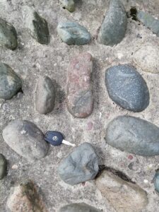
Figure 1. The incorporation of cobbles derived from glacial till into concrete. A common site in post-World War 2 redevelopment sites.
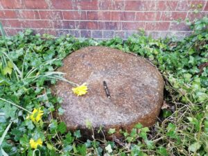
Figure 2. An erratic bock of a distinctive granite sourced from Shap Fell in north-west England now incorporated in the landscaping of the University of Leeds campus. The origin of this block is over 130 km northwest of its present location.
These large particles from the till, wherever they are incorporated into the built environment, form an invaluable educational resource for teaching and learning about the unconsolidated deposits and Quaternary history. The range of rock types present can be astounding, providing opportunities for rock description and identification not usually available locally. Once identified they provide the opportunity for students to reconstruct past ice movements by tracing their bedrock sources. A distinctive porphyritic granite from a geographically very limited outcrop on Shap Fell in north-west England for example has been used to reconstruct the passage of ice from the north-west of England’s Lake District across the Pennine Hills and into eastern England (Fig. 2). Another distinctive granitic igneous rock forming Criffel Hill in south-west Scotland can be traced southward in glacial deposits to North Wales, a distance of over 160 km (BRITICE 2017). Many less spectacular examples can be used in the same way to reconstruct past ice movement, always assuming the pieces were sourced from the local till as in more recent times with the rise of stone imports and reductions in transportation costs this assumption may no longer necessarily be the case.
One way to successfully incorporate locally derived cobbles into an educational installation is through the use of gabions (Parsons et al. 2018). A gabion is a mesh cage or box filled with rocks used in civil engineering, often for purposes of erosion control. They are often stacked to form a retaining wall and are familiar sights on any large-scale construction projects. Small versions are readily available for use in domestic gardens and small-scale groundworks (Fig. 3). This method has been used to enable glacial materials, usually only visible at coastal outcrops 90 km to the east of the city of Leeds, to be incorporated into the geological trail developed on the Meanwood Valley Urban Farm environmental education center in the city (Meanwood Valley Urban Farm undated) (Fig. 4). The accompanying interpretation materials were carefully designed to give the ‘collection of rocks in a cage’ geological context and explain the contrast between this element of the geological trail and those elements consisting of a single large block. The rock identifications derived from matching the cobbles with blocks elsewhere in the geological trail were then used to understand the provenance of the cobbles by using a simplified geological map of Britain. An alternative approach which proved successful with some groups was that of the ‘wall game’ (Robinson 1998). In this case, students were encouraged to identify as many different rock types as possible in the gabion, the diverse range of rock types providing the opportunity to describe and identify geological materials not available locally.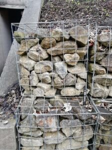
Figure 3. Gabions in use for landscaping. Here filled with blocks derived from Permian age dolostones. The use of such structures to display cobble materials enables the incorporation of such materials into geo-educational structures such as rock trails.
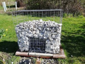
Figure 4. A gabion being used to display cobbles and pebbles of Cretaceous aged chalk (coccolithic limestone) in a purpose built geo-educational setting. These cobbles are derived from the glacial deposits and show a lithology rarely seen in outcrop other than working quarries or coastal exposures and are poorly suited to use as a building stone. Here it has been made available for study in the urban environment.
Discussion
One of the great strengths of using urban geoheritage for educational purposes is that it enables people to access geological materials from beyond the local environment. Thus, the provision of glacially derived cobbles within a gabion provides an innovative solution to making these materials accessible to the urban population - especially to those who do not have the means of accessing the rocks in situ. The accessibility of geological material is particularly important, as demonstrated by The Geological Society (the professional and regulatory body for geoscience practice in the UK) who have pledged their commitment to inclusion and diversity within geoscience education (Geological Society undated). Providing an opportunity where everybody has access to geological materials is a key part of ensuring our discipline is truly inclusive so ensuring we incorporate ‘difficult’ rock types such as unconsolidated deposits into educational practice is a challenge we need to accept.
Conclusions
Of the various solutions discussed in this paper to the problem of bringing the existence and importance of unconsolidated deposits to the attention of the wider population, here considered in the social and geological contexts of the British Isles, only outcrop preservation brings the whole range of materials are visible. The incorporation into urban contexts, whether deliberate or as a by-product of urban planning usually only provides access to the large particles and thus introduces a bias to study and potentially to the understanding of the materials. The nature of erosional and transportation processes involved during a glaciation leads to the preferential destruction of softer rock types. This results in the preferential preservation of more indurated, often crystalline materials. They do however at least in part potentially overcome the need for long-distance travel to visit the outcrops avoiding the associated financial and cultural barriers to accessing the outcrops. A simple method whereby where the entire range of grain sizes which make up unconsolidated deposits and so give a true picture of their complexity can be incorporated into our built geoheritage and thus become available for educational use will be very welcome.