Introduction
The dinosaur track site Bad Essen-Barkhausen is an abandoned quarry located in the UNESCO Global Geopark TERRA.vita (hereafter called Geopark), NW Germany (Fig. 1). Geotouristic visitors can view a siltstone layer containing several sauropod and theropod trackways, with a glass roof protecting the paleontological findings. The in-situ geoconservation of the site became a matter of public concern in the 1960s. The Geopark (established as “Nature park Nördlicher Teutoburger Wald/Wiehengebirge e.V.” in 1962) has been involved in its development since the 1970s, and today this in-situ geosite is one of the most visited geotouristic highlights in the Geopark (Härtling & Meier 2017). The dinosaur tracksite evolved from its discovery at an active mining site to the present open-air museum, and will celebrate its centenary in 2021.
The Barkhausen Dinosaur Tracksite has substantially contributed to the understanding of dinosaur ichnotaxonomy and of Late Jurassic dinosaurs in Europe (Kaever & de Lapparent 1974; Lockley et al. 1996, 2000; Lockley & Meyer 2000). These were the first Late Jurassic sauropod tracks discovered worldwide, while the Barkhausen megalosaur tracks are the first Late Jurassic theropod tracks found in Central Europe. Further occurrences of sauropod footprints and tridactyl tracks of different types in the Wiehen Mountains were reported from the Bruns Quarry in Lübbecke-Nettelstedt and the Müller Quarry (former Störmer Quarry) in Bergkirchen-Wallücke (Diedrich 2011); tracks found at these localities belong to the same stratigraphic interval as at Barkhausen. The closest Upper Jurassic site outside the Geopark area is the Langenberg Quarry near Goslar in the Harz Mountains, where tracks from small sauropods and large theropods have been documented (Lallensack et al. 2015). More than 50 Upper Jurassic dinosaur tracksites are known from six regions in Central Europe, which apart from the Wiehen Mountains and Harz Mountains in Germany, include the Holy Cross Mountains in Poland, the Jura Mountains in Switzerland and France and Lot in France (Lallensack et al. 2015).
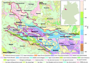
Figure 1. The geologic map of the Geopark area 1:1.000.000 showing the location of the Barkhausen Dinosaur Tracksite (geologic data from Toloczyki et al. 2006). The inset map indicates the location of the UNESCO Global Geopark TERRA.vita in Germany.
Dinosaur Tracks of Bad Essen-Barkhausen
Geological Setting
The dinosaur track site is located in the Hunte Valley and encompasses two inactive quarries 800 m south of the village Barkhausen in the local community of Bad Essen; the southern quarry and the dinosaur track quarry (coordinates: 52°16’41.7’’N, 8°24’50.1’’E; Fig. 1). An exposure of Upper Jurassic rocks exhibits frequently alternating facies, which are interpreted as sequences and cyclothems resulting from the variable paleogeographic setting of the Geopark area in the western part of the Lower Saxony Basin (Klassen 2006, 2014). During the Alpine Orogeny of the Late Cretaceous, the strata were uplifted to form the Wiehen Mountains and currently dip to the northeast at about 60° (Bailly et al. 2000).
The existing chronology for the local Upper Jurassic sediments is only based on a sequence stratigraphic approach (Klassen 2014). The local sediments show only rare ammonites, but ostracods can offer some biostratigraphic evidence (Schmidt 1955; Schudack 1994; Klassen 2014). To date, biostratigraphic or chemostratigraphic approaches have not been applied.
In the southern quarry, the bottom part of the section comprises calcareous sandstones. Layers enriched with spicules of the siliceous sponge Rhaxella perforata (“Würmeriges Gestein”) alternate with layers of dark blueish sandstones called “Blauer Stein”. These strata are part of the Oxfordian Heersum Formation (STG 2016; Rhaxen Formation in Klassen 2014) and were deposited in calm water of a shallow marine environment. At the top of the southern quarry section, the lithology changes to flasery, thin-bedded sandstones as well as to the plant-fossil-rich Wiehen Mountain Quartzite (“Wiehengebirgsquarzit”), indicating the beginning of a regional regression (Klassen 1984; Klassen 2014). The disarticulated plant remains found in these strata were assigned to cycads, Bennettitales and ginkgophytes (Friese 1962; Schultka 1991).
The section continues 100 m to the north into the dinosaur track quarry exposing lower Kimmeridgian sandstones of the Humeralis Formation (Klassen 2014). The sandstones are overlain by alternating layers of calcareous marl, marly clay and limestones of the middle Kimmeridgian Unterbank Formation (Klassen 2014). The most characteristic layers within this formation are red-colored claystones. Their name “Bröckeltonstein” is based on polyhedral weathering of the sediment due to its slickenside-like structure (Klassen 1968; Bailly et al. 2000). In general, these claystones lack plant remains as well as indicators for root penetration at the Barkhausen site, but bioturbation is a typical characteristic (Bailly et al. 2000). The “Bröckeltonstein” has been interpreted as a paleovertisol as well as a result of synsedimentary soil formation influenced by peloturbation and indicates deposition at the end of a regression sequence close to the land (Bailly et al. 2000; Klassen 2006).
The “Bröckeltonstein” alternates with siliceous claystone and siltstone beds characterized by cross bedding. The dinosaur tracks are imprinted on these thin-bedded clayey siltstone layers (Friese 1962, 1967, 1972; Klassen 2014). Originally, the dinosaur track layer also appeared to show finer trace fossils and structures such as mud cracks, arthropod traces and raindrop impressions (Imeyer 1926; Klüpfel 1931), but exposure has rendered these structures unrecognizable from the 1970s (Friese 1972).
In the upper part of the dinosaur track quarry section, calcareous fine-grained sandstones of the Unterbank Formation overlie the clayey siltstone layers (Klassen 2006). The thickness of these sandstone beds varies significantly, and some beds pinch out still indicating shore proximity (Friese & Klassen 1979). The top of the succession is composed of limestones and calcareous sandstones of the middle Kimmeridgian Stollenbank Formation, which suggests an ingression of the sea (Klassen 2014).
In-situ Dinosaur Tracks
The Barkhausen Quarry wall reveals at least 110 dinosaur footprints on single rock layer with a length of c. 22 m and a height of c. 12 m (Fig. 2A). The imprints can be classified as rounded (sub-circular) and tridactyl tracks. Most of the footprints belong to the rounded type, were described as Elephantopoides barkhausensis and assigned to sauropods (Fig. 2B–C; Ballerstedt 1922; Schmidt 1959; Kaever & de Lapparent 1974; Friese & Klassen 1979; Lockley & Meyer 2000). The hind feet of these sauropod tracks were only 32 to 38 cm long and the step length was almost 2 m (Friese 1972; Lockley et al. 2000). Therefore, the tracks have most probably been left by narrow-gauge sauropods of small size (Lockley & Meyer 2000). Several authors (Lockley et al. 1994; Wright 2005) considered Elephantopoides barkhausensis as a nomen dubium because of the inadequate diagnosis by Kaever & de Lapparent (1974); for this reason, the Elephantopoides taxon is currently being under revision (Meyer et al., in prep.).
Nine sauropod trackways follow one another and lie parallel to each other, indicating gregarious behavior (Fig. 2A). All trackways trend in the same direction, indicated by a bulge in front of each footprint, which was created by pushing the toes into muddy sand. The sauropods headed in a direction now down the face of the present outcrop, i.e., to the northeast (Friese 1972; Friese & Klassen 1979; Lockley & Meyer 2000).
Kimmeridgian tracks of small-sized sauropods and fossil finds of the small sauropod Europasaurus holgeri were described from the geographically and stratigraphically close Langenberg Quarry in the Harz Mountains (Lallensack et al. 2015; Sander et al. 2006). Therefore, it is plausible that a small-sized member of the sauropod group Camarasauromorpha related to Europasaurus is responsible for the Barkhausen tracks and that the small-sized Barkhausen sauropods could support the insular dwarfism theory of Sander et al. (2006). However, this inference needs further investigation.
The up to 63 cm long tridactyl footprints are almost twice as long as the sauropod tracks and originate from large theropods, most likely a taxon of the megalosaurid family (Fig. 2B; Schmidt 1959; Friese 1972; Kaever & de Lapparent 1974; Haubold 1984; Lockley et al. 1996, 2000; Lockley & Meyer 2000). Initially, they were described as Megalosauropus teutonicus by Kaever & de Lapparent (1974) but proved to be synonymous and therefore were attributed to the ichnogenus Megalosauripus, written with an “i” (Lockley et al. 1996, 2000). Ongoing investigations may help to refine the Megalosauripus teutonicus taxon (Meyer et al., in prep.).
Trackways of two individuals were identified; the first theropod left at least three footprints heading towards the southwest, in the opposite direction to that of the sauropod trackways. The other megalosaur walked from the east to the west (WNW) and left four impressions (Lockley & Meyer 2000). Both megalosaur trackways do not indicate a wide gauge (Lockley et al. 2000).
There is evidence for a second stratigraphical horizon 86 cm above the main track horizon containing further Elephantopoides barkhausensis tracks (Imeyer 1926; Klüpfel 1931; Diedrich 2011). This younger layer has probably been affected by dinoturbation (Klüpfel 1931; Diedrich 2011). The arrangement of the sauropod tracks in this second horizon appears disorganized, which makes establishing the number of individuals and their direction of movement more challenging to interpret.
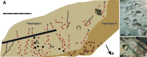
Figure 2. The dinosaur trackways of Bad Essen-Barkhausen. A) Map of the Barkhausen Dinosaur Tracksite. 1–9: sauropod trackways; a–b: theropod trackways; bar equals 5 m (modified after Lockley & Meyer 2000). B) Sauropod trackway 3 and theropod trackway a; bar equals 0.5 m. C) A footprint of Elephantopoides barkhausensis from trackway 7 and ripple marks; bar equals 0.5 m.
Reconstruction of the Paleoenvironment
The Barkhausen Dinosaur Tracksite was located at about 35–40°N during the Late Jurassic (presently 52° N; e.g., Seton et al. 2012), north of the Rhenish Massif at the northern edge of the Northwestphalian-Lippian Aquatic Sill and south of the Cimbrian Landmass (e.g., Klassen 1984; Ziegler 1990). The Geopark area was located in a shallow marine basin and was flooded three times during the Late Jurassic, with the only connection to the Neotethys to the east (Bailly et al. 2000; Klassen 2003, 2006, 2014). The reddish claystones “Bröckeltonstein” indicate an early stage of soil formation in a semiterrestrial environment (Bailly et al. 2000; Klassen 2006, 2014). The depositional environment was interpreted as an occasionally flooded lacustrine or lagoon-like setting, influenced by low-energy fluvial systems (Bailly et al. 2000). Cross bedding, desiccation cracks, arthropod crawling marks and raindrop impressions on the same siliceous clayey siltstone layers that host the dinosaur tracks support the proximity to the shore and occasional drying out of the ground (Fig. 2C; Ballerstedt 1922; Imeyer 1926; Klüpfel 1931; Friese 1972).
In conclusion, the Barkhausen dinosaurs most probably migrated parallel to the shore across a coastal area (Bailly et al. 2000; Klassen 2006, 2014). Since there is no geologic evidence of land bridges, it remains unclear if a faunal exchange between dinosaurs from different Central European islands took place during the Kimmeridgian (Lallensack et al. 2015).
History of Research, Geoconservation and Environmental Education
Discovery and scientific processing
The Barkhausen Quarry exhibiting the dinosaur tracks (originally known as the “Vathauer Quarry”, named after the first owner) had been set up to mine thick-bedded fine-grained sandstones stratigraphically overlying the dinosaur track layer to use them as building material and road gravel (Friese & Klassen 1979). The thin-layered clayey siltstones containing the footprint impressions were not of economic interest. Walther Klüpfel discovered the tracks in early 1921 in the course of field mapping for the iron smelting industry (Fig. 3A; Friese 1972). By that time, the tracks had already been exposed for nine years (Klüpfel 1931). Klüpfel entrusted the scientific processing of the findings to Max Ballerstedt, a specialist in the Bückeburg dinosaur tracks. Ballerstedt had initially described and illustrated the Barkhausen tracks for a weekly supplement to a local newspaper (Wittlager Kreisblatt no. 23, issue II, 11th June 1921) and then as a scientific publication (Ballerstedt 1922). When Ballerstedt described the footprints, only the two easternmost sauropod trackways were visible. Further footprints were exposed later by breaking off the overlying rock layers. Imeyer (1926) and Schott (1930) mentioned the tridactyl tracks for the first time. The first detailed profile surveys of the two Barkhausen quarries were published by Imeyer (1926) and Klüpfel (1931).
The first taxonomic descriptions of both the rounded and the tridactyl footprints of Barkhausen were published more than 40 years later (Kaever & de Lapparent 1974). Because these descriptions lacked adequate diagnoses, the presumed megalosaur tracks were named as Megalosauripus teutonicus based on new measurements (Lockley et al. 2000), while the taxonomic definition of the sauropod tracks (Elephantopoides barkhausensis) still need to be revised. The westernmost tracks of the older main track layer and the second younger track layer were covered by soil and vegetation for decades until they were rediscovered during the construction of the glass roof in 1999 (Fig. 3C). After cleaning this layer of soil and vegetation in 2020, it is now again visible. Modern techniques such as photogrammetric measurements have not yet been applied to the Barkhausen dinosaur tracks, except for one sauropod trackway that was measured photogrammetrically (Läbe 2017).
Cast preservation
The preservation of the dinosaur tracks has been an important issue since their discovery. Fortunately, the dense joint set in the track layer prevented the ichnofossils from being removed from the site. Consequently, making plaster casts was the only way to preserve the tracks. New casts using modern techniques have been taken several times in recent years.
Imeyer took plaster casts of the first trackway group including the two easternmost sauropod trackways for the Osnabrück Museum Association in 1926 (Friese 1972; Friese & Klassen 1979). Plaster casts of a further trackway group including two sauropod trackways, the southwest trending megalosaur trackway as well as one footprint of the second megalosaur trackway were taken in 1960. This effort was supported by the City of Osnabrück and the former County of Wittlage (Friese & Klassen 1979). Another plaster cast of the footprints was taken by the Geological Survey of Lower Saxony in Hanover (NLfB) in 1974 (Friese & Klassen 1979). Initiated by the Natural History Museums in Osnabrück and Münster, the first recovery of silicone casts of the trackways was carried out in 1985. These measures were prompted by progressive decay of the plaster casts. The working group of Martin G. Lockley made latex molds of selected sauropod footprints during their fieldwork in 1998 and 1999. The molds were converted into fiberglass replicas; they are stored and cataloged in the fossil footprint collection of the University of Colorado Museum (UCM) as UCM 193.10 – UCM 193.12.
Replicas of the dinosaur track casts are exhibited in the Natural History Museums of Osnabrück and Münster, the Dinosaur Park Münchehagen, by a local restaurateur (“Saurierwirt” in Barkhausen, a descendant of the former quarry owner Vathauer; Friese & Klassen 1979) and, for a limited period of time, in the Natural History Museum of Hanover.
In-situ conservation
The dense joint set of the dinosaur track layers and the high leaching potential of the underlying “Bröckeltonstein” pose a challenge to the in-situ geoconservation efforts (Friese & Klassen 1979). These lithological characteristics induce high pressure in the dinosaur track layers via evaporation of water in summer and frost in winter. An additional factor is the continuous growth of plants in the joints due to the temperate climate. Therefore, the rock layer requires regular sealing and impregnations as well as yearly vegetation removals.
The first impregnation of the dinosaur tracks took place in 1962, more than 40 years after their discovery. More extensive conservation measures were carried out during the establishment of the open-air museum from 1974 to 1976 (Friese & Klassen 1979). About 43 tonnes of cement slurry were injected through 17 boreholes, each up to 6 m deep. The hardened cement currently forms a 5.0-m-thick block in the rock material behind the dinosaur track layer (Friese & Klassen 1979). Additionally, a concrete rain gutter was installed above the tracks to drain rainwater. Moreover, the western wall displaying the thick sandstone beds above the dinosaur track layer has been cleared of plants and rocks. These very costly measures were only possible thanks to joint funding by Osnabrück County, the federal state of Lower Saxony and the Geopark. The impregnation of the track layer was repeated in 1984; at the same time, the joints were sealed. Both measures were taken again in 1995 with financial support from the Osnabrück County.
The latest considerable effort to protect the Barkhausen dinosaur tracks was made by the Geopark and Osnabrück County in 2000 as part of the development program for the open-air museum. A 17.6-m-long and 10.7-m-broad glass roof was constructed over the dinosaur tracks to protect them from direct exposure to weather conditions (Fig. 3D). The lateral openings in the roof prevent it from heating through the greenhouse effect, and they create a more even temperature beneath the roof. Since then, TERRA.vita, Osnabrück County, the City of Bad Essen and the Experiential Pedagogical Country Hostel Barkhausen have taken smaller-scale protective measures such as regularly removing plants and improved visitor guidance. New impregnation measures as well as an extension and restoration of the rain gutter are scheduled for 2021.
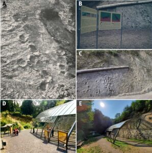
Figure 3. The evolution of the Barkhausen Dinosaur Tracksite. A) The earliest known photograph of the tracksite from 1921. Only sauropod trackways 1 and 2 (see Fig. 2A) were exposed (Photo: Eberhard, in Imeyer 1926). B) Information panels set up for the opening of the open-air museum in 1976 (Photo: Museum am Schölerberg). C) The track layer after extension to the west in 1999 (Photo: Museum am Schölerberg). D) The expansion of the open-air museum in 2000 (Photo: TERRA.vita). E) The Barkhausen Dinosaur Tracksite in 2020 (Photo: TERRA.vita).
Legal Protection
The protection status sets a primary basis for geoconservation of the Barkhausen dinosaur tracks. The geosite has been protected as a natural monument by the former Wittlage County since 1936. After Wittlage County was transferred to Osnabrück County in 1972, the nature conservation authorities of Osnabrück County take care of conservation. Furthermore, the Academy for Geosciences and Geotechnologies in Hanover recognized the dinosaur tracks of Bad Essen-Barkhausen as a “National Geotope” in 2019, the highest rank for geosites in Germany. This award does not provide legal protection, but highlights the importance and value of the geosite for the region and binds the authorities to the maintenance and protection of the geosite. The track site receives further support as part of the Geopark and thus of the UNESCO Global Geopark network, which facilitates regional projects aiming to enhance its conservation (Fischer 2020).
Environmental Education Measures and Establishment of the Open-air Museum
The dinosaur tracks have been accessible to visitors since their discovery. A nature guide brochure led visitors to the geosite (Bödige 1921); later on, the dinosaur tracks were signposted (Friese 1972). The course of conservation work in 1962 was accompanied by publication of the booklet “Wittlager Heimatheft 5,” providing the public with detailed information on the dinosaur tracks. The brochure was regularly reissued (Friese 1962, 1967, 1972).
Marked by the opening of the Barkhausen Geological Open-air Museum, the year 1976 was a milestone for environmental education at the geosite. Developments associated with the opening of the museum included preservation of the dinosaur tracks on a larger scale, setting up information panels and facilitating public access to the quarry (Fig. 3B; Friese & Klassen 1979). At the same time, new exposures were created to give visitors an impression of the lithologies under- and overlying the dinosaur track layer, such as the “Bröckeltonstein”, the calcareous sandstone beds and the limestones. For the first time, three large and two small information panels provided visitors with geological information on the dinosaur track layer and on the new exposures (Friese & Klassen 1979). The open-air museum is still accessible to all visitors free of charge. The idea of an open-air museum at Barkhausen was promoted by Horst Klassen from the Natural History Museum in Osnabrück in cooperation with the Osnabrück County and the Geopark.
The latest major advancement of the open-air museum was initiated by the Geopark in collaboration with Osnabrück County in 2000. The new developments involved the construction of a glass roof over the dinosaur tracks and extension of the dinosaur track layer further to the west (Fig. 3C, D). Furthermore, the information panels were renewed and two life-sized models of a megalosaur and a camarasaur were installed to give visitors an idea of the appearance of the animals that left the tracks. At the same time, access to the site was made barrier-free for visitors. Two of the present authors, Martin Lockley and Christian Meyer, were invited to Barkhausen as paleontological specialists to remap and reassess the megalosaur tracks and revise the megalosaur track concept (Lockley et al. 2000; Lockley & Meyer 2000).
These developments have raised public awareness of touristic opportunities at Barkhausen on a supra-regional scale. The Geopark currently offers signposted hiking and cycling routes (“TERRA.track Megalosaurus”, “TERRA.trail 04”, “DiVa-Walk”), which lead visitors to the dinosaur tracks. The geosite was equipped with new hiking shelters and benches in 2020 in the course of the Geopark’s hiking masterplan. The Geopark’s nature guides (TERRA.guides) offer guided tours to a number of regional highlights in the Geopark including the Barkhausen dinosaur tracks. The adventure educators from the Experiential Pedagogical Country Hostel Barkhausen guide 1,800 students to the tracks every year. Six large panels in TERRA.vita’s corporate design were installed at the Barkhausen dinosaur tracks in 2007, giving visitors geological information not only in German, but, for the first time, also in English. In 2018, those panels were updated and now provide additional information on other dinosaur relics in the region (Fig. 3E). Furthermore, casts of the dinosaur tracks have been presented as a part of the Geopark’s palaeontological exhibition “TERRA.vision” in the Natural History Museum of Osnabrück (“Museum am Schölerberg”) since 2008. The Barkhausen Dinosaur Tracksite is also an annual venue of the Geopark to mark the Germany-wide “Day of Geotopes” (“Tag des Geotops”) in close cooperation with the Experiential Pedagogical Country Hostel Barkhausen and the Development Association Barkhausen. All this makes the Barkhausen Dinosaur Tracksite one of the most visited highlights in the Geopark (Härtling & Meier 2017). The eco-counter placed at the site indicates more than 15,000 visitors per year.
Conclusions
The dense joint set in the rock layers containing the Barkhausen dinosaur tracks was regarded as obstacles in the first half of the 20th century because they precluded recovery of individual footprints from the geosite. However, these limitations have now been turned to advantages, allowing an in-situ preservation of the dinosaur tracks. This offers paleontologists a rare opportunity to examine the findings at the original discovery site 100 years later. In this way, the Barkhausen Dinosaur Tracksite still provides new data on the ichnotaxonomy and paleoecology of Jurassic dinosaurs in Central Europe.
The decommissioning of the quarry in Barkhausen and the early legal protection of the dinosaur tracks as a natural heritage played an important role in their preservation. In addition, the geosite has been one of the most exciting regional touristic destinations for local people and visitors from abroad since the discovery of the tracks. This created favorable circumstances in which local authorities, museums and associations were encouraged to reinforce geoconservation of the dinosaur tracks and transform the geosite into an open-air museum.
For more than 20 years, the UNESCO Global Geopark TERRA.vita has been emphasizing the importance of the dinosaur tracks in Barkhausen and contributing to geoconservation and environmental education at the geosite. Infrastructure developments such as a protective glass roof, dinosaur models, information panels and resting places, the integration of the geosite into the hiking and cycling network as well as the organization of regular public events and guided tours allowed the dinosaur tracks to become a touristic hotspot and one of the first and best examples of in-situ geoconservation.
Acknowledgments
The authors thank Jessica Meissner from the Nature Conservation Agency of Osnabrück County for providing detailed information on the geoconservation measures from the county’s archive, and Angelika Leipner from the Museum am Schölerberg, Osnabrück, for providing historical photographs from the museum’s archive. Polina Vakhrameeva, Heidelberg University, is thanked for the discussions. We thank two anonymous reviewers for their constructive comments and suggestions, which helped us to improve the manuscript.
Conflict of interest
The authors declare that there is no conflict of interest in their work.
References
Bailly F, Felix-Henningsen P, Klassen H & Stephan S (2000). Synsedimentäre Paläo-Vertisole im Oberjura des westlichen Wiehengebirges. Osnabrücker Naturwissenschaftliche Mitteilungen. 26: 15-46
Ballerstedt M (1922). Über Schreckensaurier und ihre Fußspuren. Kosmos. Handweiser für Naturfreunde. 19: 77-80
Bödige N (1921). Saurierfährten bei Barkhausen. Osnabrück und seine Berge, Wegweiser durch den Teutoburger Wald und das Wiehengebirge.
Diedrich CG (2011). Upper Jurassic tidal flat megatracksites of Germany—coastal dinosaur migration highways between European islands, and a review of the dinosaur footprints. Palaeobiodiversity and Palaeoenvironments. 91: 129-155
Fischer T (2020). Wertgebende Landschaften und Landschaftselemente im Natur- und UNESCO Geopark TERRA.vita. Natur- und Geopark TERRA.vita Nördlicher Teutoburger Wald, Wiehengebirge, Osnabrücker Land e. V., Osnabrück.
Friese H (1962). Die Dinosaurierfährten von Barkhausen im Wiehengebirge. Wittlager Heimathefte. 5: 1-22
Friese H (1967). Die Dinosaurierfährten von Barkhausen im Wiehengebirge. Wittlager Heimathefte. 5: 1-22 (2nd Ed)
Friese H (1972). Die Dinosaurierfährten von Barkhausen im Wiehengebirge. Wittlager Heimathefte. 5: 1-22 (3rd Ed)
Friese H & Klassen H (1979). Die Saurierfährten von Barkhausen im Wiehengebirge. Veröffentlichungen des Landkreises Osnabrück. 1: 1-36
Härtling JW, Meier I (2017). Die wirtschaftliche Bedeutung des Tourismus im UNESCO Global Geopark TERRA.vita („Naturpark Nördlicher Teutoburger Wald, Wiehengebirge, Osnabrücker Land e.V.). Endbericht 2017. Survey conducted by the Institute for Geography at the Osnabrück University.
Haubold H (1984). Saurierfährten. Lutherstadt Wittenberg: Die Neue Brehm-Bücherei.
Imeyer F (1926). Vergleichend-stratigraphische Untersuchung der Faziesverhältnisse des Oberen Juras von den Heersumer Schichten bis zu den Gigasschichten im Wiehengebirge und Teutoburger Walde. Jahresbericht des Naturwissenschaftlichen Vereins zu Osnabrück. 19: 1-79
Kaever M & de Lapparent F (1974). Les traces des pas le Dinosaures due Jurassique des Barkhausen (Basse Saxe, Allemagne). Bulletin de la Société Géologique de France. S7-XVI: 516-525
Klassen H (1968). Stratigraphie und Fazies des tieferen Malm im Wiehengebirge und Teutoburger Wald. Veröffentlichungen des naturwissenschaftlichen Vereins Osnabrück. 32: 39-96
Klassen H (1984). Malm. In Geologie des Osnabrücker Berglandes (pp 387-426). Osnabrück: Naturwissenschaftliches Museum Osnabrück
Klassen H (2003). Zur Entwicklungsgeschichte des nördlichen Osnabrücker Berglandes. Osnabrücker Naturwissenschaftliche Mitteilungen. 29: 13-43
Klassen H (2006). Zyklotheme in den Oxford- und Kimmeridge-Abfolgen des westlichen Niedersachsen-Beckens. Osnabrücker Naturwissenschaftliche Mitteilungen. 32: 7-21
Klassen H (2014). Sequenzlithologische Gliederung der Oberjura-Abfolgen im westlichen Niedersachsen-Becken. Osnabrücker Naturwissenschaftliche Mitteilungen. 39/40: 43-110
Klüpfel W (1931). Stratigraphie der Weserkette (Oberer Dogger und Malm unter besonderer Berücksichtigung des Ober-Oxford). Abhandlungen der Preußisch Geologischen Landesanstalt. 129: 1-423
Läbe S (2017). Estimating sauropod body mass and gait by the analysis of recent and fossil tetrapod tracks with photogrammetry and soil mechanics. Dissertation, University of Bonn, Germany.
Lallensack JN, Sander PM, Knötschke N & Wings O (2015). Dinosaur tracks from the Langenberg Quarry (Late Jurassic, Germany) reconstructed with historical photogrammetry: Evidence for large theropods soon after insular dwarfism. Palaeontologia Electronica. 18.2.31A: 1-34
Lockley MG, Farlow JO & Meyer CA (1994). Brontopodus and Parabrontopodus ichnogen. nov. and the significance of wide- and narrow-gauge sauropod trackways. GAIA. 10: 135-145
Lockley M & Meyer C (2000). Dinosaur tracks and other fossil footprints of Europe. New York: Columbia University Press.
Lockley MG, Meyer CA & dos Santos VF (1996). Megalosauripus, Megalosauropus and the Concept of Megalosaur Footprints. Museum of Northern Arizona Bulletin. 60: 113-118
Lockley MG, Meyer CA & dos Santos VF (2000). Megalosauripus, and the problematic concept of Megalosaur footprints. GAIA. 15: 313-337 (for 1998)
Sander PM, Mateus O, Lave T & Knötschke N (2006). Bone histology indicates insular dwarfism in a new Late Jurassic sauropod dinosaur. Nature. 441: 8
Schmidt G (1955). Stratigraphie und Mikrofauna des mittleren Malm im nordwestdeutschen Bergland. Abhandlungen der Senckenbergischen Naturforschenden Gesellschaft. 491: 1-76
Schmidt H (1959). Die Cornberger Fährten im Rahmen der Vierfüßler-Entwicklung. Abhandlungen des Hessischen Landesamtes für Bodenforschung. 28: 1-137
Schott W (1930). Paläogeographische Untersuchungen über den Oberen Braunen und Unteren Weißen Jura Nordwestdeutschlands. Abhandlungen der Preußischen Geologischen Landesanstalt, Neue Folge.133: 1-51
Schudack U (1994). Revision, Dokumentation und Stratigraphie der Ostracoden des Nordwestdeutschen Oberjura und Unter-Berriasium. Berliner geowissenschaftliche Abhandlungen. E11: 1-193
Schultka S (1991). Beiträge zur oberjurassischen Flora des Wiehengebirges. Geologie und Paläontologie in Westfalen.19: 55-93
Seton M, Müller RD, Zahirovic S, Gaina C, Torsvik T, Shephard G, Talsma A, Gurnis M, Turner M, Maus S & Chandler M (2012). Global continental and ocean basin reconstructions since 200 Ma. Earth-Science Reviews. 113: 212-270
STG (2016). Stratigraphic Table of Germany 2016. German Stratigraphic Comission (Ed.). Potsdam: German Research Centre for Geosciences.
Toloczyki M, Trurnit P, Voges A, Wittekindt H & Zitzmann A (2006). Geologische Karte der Bundesrepublik Deutschland 1:1.000.000 (GK1000) (4th Ed). Hannover: Bundesanstalt für Geowissenschaften und Rohstoffe.
Wright JL (2005). Steps in understanding sauropod biology. In: The Sauropods: Evolution and Paleobiology, pp 252-285. Oakland: University of California Press.
Ziegler PA (1990). Geological Atlas of Western and Central Europe (2nd Ed). Bath: Geological Society Publishing House.