Introduction
The fascination of being close to nature's power and the geodiversity of landforms make volcanic eruptions one of the most attractive geological processes. Volcanic areas are popular for geotourism, such as Yellowstone and Kilauea in the United States or Etna and Santorini in Italy and Greece (Sigurdsson & Lopes-Gautier 2000; Erfurt-Cooper 2014; Erfurt-Cooper et al. 2015). The importance of volcanic and geothermal environments for the tourism sector has been recognized with the development of volcano-based National Parks and more recently, National and Global Geoparks where geomorphosites containing active volcanism are promoted as tourist attractions (Erfurt-Kooper 2014). However, there are numerous inactive volcanic areas that still preserve their primary scenery and where the effects of erosion allow exploration of the interior of lava flows and deposits from explosive activity without the potential danger of approaching an active volcano.
The Cabo de Gata-Níjar UNESCO Global Geopark is an exceptional and extensive volcanic outcrop from the Miocene epoch located in the extreme southeast of Spain (Fig. 1A). It shows the main geological features of effusive and explosive volcanism that took place in subaerial and submarine contexts. Submarine volcanism constitutes more than 75% of current volcanic eruptions. However, it is largely unknown due to the difficulty of observing processes and deposits in these contexts. Therefore, the possibility of studying outcrops of this type that have been exposed and are currently in a subaerial location provides a unique opportunity to broaden knowledge of the processes that govern this type of volcanic activity. In addition, the existence of important deposits related to subaerial explosive activity, make this geopark an important scientific and geotourism attraction from a volcanological point of view.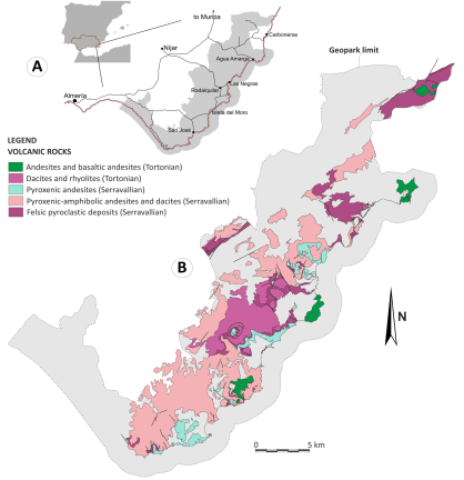
Figure 1. A) Location of the Cabo de Gata-Nïjar UNESCO Global Geopark in the southeast of the Iberian Peninsula. B) Geological map of the geopark with the location of the volcanic rocks. Serravallian and Tortonian are, in the geological timescale, ages in the middle Miocene Epoch. The location of the geopark is shown in gray.
The aims of this paper are to introduce the geoheritage in Cabo de Gata geopark and to show its scientific significance, to analyze geoconservation and geotourism and to discuss the main problems in preserving geoheritage and developing geotourism in a mature tourism destination that is well known at national and international level.
Geological Setting
The Cabo de Gata Geopark shows the main geological features of submarine effusive volcanism of andesitic to dacitic composition, as well as important pyroclastic deposits related to the explosive activity of felsic magmas (Fig. 1B). These volcanic rocks are interbedded with carbonate and siliciclastic sedimentary rocks deposited during periods of volcanic repose. The fossil content of these sedimentary rocks indicates a marine context, commonly shallow waters (oysters, corals, echinoderms, bryozoans, shells, and algae). In addition, the sedimentary structures also indicate depositional environments above the wave base level in stormy periods, which are normally located between 50 and 100 m deep (Fernández -Sóler 1996; Soriano et al. 2013; Soriano et al. 2014; Soriano et al. 2020).
In submarine environments, effusive volcanism generates submarine lava flows and domes, depending on the viscosity and emission rate of the magma. The edges of these bodies cool abruptly on contact with water and fragment non-explosively. This forms a shell of hyaloclastite. This shell, which is initially in situ, is subsequently remobilized by the movement of the lava, forming reworked hyaloclastite deposits. On the other hand, explosive eruptions at Cabo de Gata were commonly generated by silica-rich magmas (dacites and rhyolites). These pyroclastic deposits, which stand out for their white coloration in the landscape, are characterized by the abundance of pumice fragments (Rytuba et al. 1990; Fernández -Sóler 1996; Gómez-Pugnaire et al. 2019).
Geochronological data show that the main volcanic activity in Cabo de Gata developed for just over 7.5 million years (Ma). The oldest and most active episode took place during the Serravallian division of the Miocene (13.82–11.63 Ma) with the development of explosive volcanism, of a rhyolitic nature, which produced a significant volume of ignimbrites at Cala Rajá, Vela Blanca and Cala Higuera (Fig. 2), and effusive volcanism, with domes and submarine flows of an andesitic to dacitic nature at El Bujo, Mónsul, EI Barronal, Lo Genoveses and La Isleta del Moro (Fig. 3). During the lower Tortonian, important explosive and effusive volcanism also developed, but in this case, of a dacitic to rhyolitic nature. The Rodalquilar, El Cinto and Las Lázaras ignimbrites stand out, which are key in the formation of gold and sulfate deposits. The latest volcanic events took place in the middle Tortonian and were fundamentally effusive, with andesitic lava domes at Mesa Roldán and Cerro de Los Lobos and basaltic andesite at Cerro de La Palma (Mattei et al. 2014).
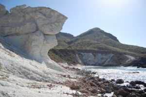
Figure 2. Pyroclastic deposits in Cala Raja.
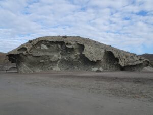
Figure 3. Hyaloclastites in Mónsul.
The volcanic rocks of Cabo de Gata have chemical features similar to those of magmatism in subduction contexts, although they are contemporaneous with an extension process that took place in the internal zones of the Betic Rif orogen. This orogen is a mountainous belt with a northern branch formed by the Betic mountain range in the Iberian Peninsula and a southern branch formed by the Rif chain in North Africa. Extensional tectonics, produced by the westward retreat of the subducting plate, ceased in the late Miocene. Its subsequent evolution led to a compressive regime dominated by strike-slip faults. The Carboneras Fault, which remains active and is responsible for a significant part of the seismic activity recorded in the region, is an example of this tectonic regime (Mattei et al. 2014).
Location of Cabo de Gata-Níjar UNESCO Global Geopark
Cabo de Gata-Níjar Geopark is located in the southeast of the Iberian Peninsula, in Almería (Andalusia) in Spain (Fig. 1A). Its extent is 495.12 km² and includes more than 60 km of coastline, mostly unexploited, making it one of the last virgin coastal areas of the Spanish Mediterranean and the largest protected area of these characteristics in the entire western Mediterranean in Europe. It includes in its entirety the Sierra de Cabo de Gata and the Cape of the same name, which is geographically the most southeastern point of the entire Iberian Peninsula. Part of the coastal plains of Almería and the Serrata de Níjar is also included within the limits of the Geopark.
According to the List of Entities and Population Centers of Andalusia in the year 2020, the 18 entities of the population included within the limits of the Cabo de Gata-Níjar Natural Park have a total population of 4364 inhabitants, distributed among the municipalities of Almería (3), Carboneras (5) and Níjar (10). The main population center within the protected space is Cabo de Gata, where a quarter of the population lives, followed by San José, Pozo de los Frailes and Pujaire. These nuclei can triple their population in the summer months.
The volcanic outcrops of Cabo de Gata precisely match the exhumed part of the Betic-Rif Orogen Volcanic Arc, of which we can only find small outcrops in the Alborán Sea in the form of seamounts. Cabo de Gata is one of these small “pieces”, showing an almost complete series of emergent calc-alkaline volcanic facies and effusive to explosive and transitional regime behaviors in submarine environments. This makes it a "natural laboratory" to study volcanic processes and the products of seamounts worldwide (Soriano et al. 2016).
All this geological heritage of extraordinary value was decisive in its declaration as a Natural Park in 1987 (Decree 314/1987 Natural Park Declaration, see link below) and after this recognition, its value has been reflected by the following international designations: UNESCO-MAB Biosphere Reserve (1997); Special Protected Area for Birds (SPA 1989); Specially Protected Area of Mediterranean Importance (SPAMI 1999); Marine Reserve by the National Ministry of Spain (1995); RAMSAR site of Las Salinas de Cabo de Gata, 0.3 km2 of Wetland (1990); Geopark (2001); UGG (2015); ZEC, Natura 2000 Network (2012).
All the geological sites are subject to conservation measures and protected by national Law 42/2007, December 13th of Natural Heritage and Biodiversity, Law 2/1989, July 18th, by which the Andalusian Natural Areas Inventory is approved and further protection regulations are established as well as the cited Natural resources management master plan (Decree 37/2008, of February 5, by which the Resources Management Plan is approved and the Master Plan for Use and Management of the Cabo de Gata-Níjar Natural Park and the limits of said Natural Park are specified).
This geopark is perhaps one of the greatest natural gems of the province of Almeria. Its volcanic origin, and the prevailing sub-desert climate, have characterized the development and history of its inhabitants. The arid landscapes hide an enormous botanical richness, precisely from their uniqueness in adaptations to a ferocious climate by means of strategies to survive extreme conditions, such as endless roots, dormant seeds, salt water adaptation, and exploiting the morning dew. Ecosystems formed by the jujube (Ziziphus lotus), dwarf fan palm (Chamaerops humilis), African wolfbane (Periploca angustifolia), esparto grass (Stipa tenacissima), rosemary (Rosmarinus officinalis), thyme and grasslands, as well as the vegetation that populates cliffs and dunes, make up the botanical landscape of the park, together with traditional crops, such as sisal (Agave sisalana), prickly pear (Opuntia ficus-indica) and small orchards.
Twenty-three habitats of community interest converge in the space, seven of them of a priority nature, and including 119 species (both animal and plant) indicated in art. 4 of Directive 2009/147/CE and/or listed in Annex II of Directive 92/43/CEE, and another 218 species of flora and fauna of outstanding importance. The seven priority habitats are:
- 1120 Posidonia meadows (Posidonion oceanicae)
- 1150 coastal lagoons
- 1510 Mediterranean salt steppes (Limonietalia)
- 1520 Iberian gypsicolous vegetation (Gypsophiletalia)
- 5220 Ziziphus arborescent thickets
- 6220 Substeppe zones of grasses and annuals of Thero-Brachypodietea
- 7220 Petrifying springs with tufa formation (Cratoneurion moss)
Despite the sub-desert nature of the soil, in the geopark there are more than 1,500 species of flora, many of them endemic, forming one of the most unique, diverse and unique areas of Europe.
In the nearby ocean are extensive Posidonia oceanica meadows with a great diversity of aquatic fauna and flora favored by the convergence of the Atlantic and Mediterranean sea masses. This phenomenon, together with the different types of seabed, supports a high diversity of life with a catalog of more than 1,300 animals and 300 plants. The transparency of the waters is largely due to the presence of one of the best-preserved Posidonia oceanica meadows in the entire Mediterranean. This endemic plant of the Mediterranean Sea, which is commonly confused with an alga, plays a fundamental role in the control of erosion and as a source of oxygen and is the habitat of more than 700 animal species. Among its leaves, we can find sea urchins, starfish, sponges, molluscs, algae and fish. In the rocky backgrounds, the games of the cavities and light are colored by corals, and other fauna and flora that live attached to their walls.
The avifauna of the geopark is especially important in the coastal steppe, where steppe birds live, such as the trumpeter finch (Bucanetes githagineus), stone curlew (Burhinus oedicnemus), Dupont´s lark (Chersophilus duponti) and little bustard (Tetrax tetrax). In the Ramsar site of Salinas de Cabo de Gata, where more than 80 species are concentrated, many of them are waders such as avocets (Recurvirostra avosetta) and black-winged stilt (Himantopus himantopus), although we can also find gulls, mallards and flamingos. Common raptors include Bonelli's eagle and the eagle owl, and small mammals such as the common genet and the fox.
Phoenicians, Romans and Arabs successively occupied this territory, leaving a rich and varied cultural heritage. After the expulsion of the Arabs, the area was practically depopulated and under the continuous threat of pirates of North African origin, the reason why in the 17th century, towers and fortresses were constructed by the coast, a process that reached their maximum development during the reign of Carlos III.
The avifauna of the geopark is especially important in the coastal steppe, where steppe birds live as the trumpeter finch (Bucanetes githagineus), alcaravan (Burhinus oedicnemus), Dupont´s lark (Chersophilus duponti)
The first human settlements were created around the water, and small orchards were designed that still today stand out against the dominant ocher tones. The limited yields of rainfed crops motivated the occupation of large areas of land, creating the cereal steppe, livestock sustenance and habitat of recognized importance for unique flora and fauna. In its landscape are recognized linear structures made of stone, time and effort, which cut off the runoff and capture the scant water that slides along its sloping hillsides.
Fishery and mining resources also influenced the current distribution of boreholes. The water and wind culture has left a legacy of infrastructures such as cisterns, tanks, wells, water canals, and ditches, as well as windmills and norias (Arabic watermills), fundamental milestones in the historic configuration of the landscape. Many of these elements remain functional to this day and others have been rehabilitated by the administration in recent years.
The mining heritage exceeds these features, especially Rodalquilar and Aguamarga, although we find samples throughout the area. It was right at the center of Rodalquilar where gold was discovered for the first time in 1883, although it was not until the twentieth century that it could be exploited. After the cessation of gold activity at Rodalquilar, the Ministry of Environment purchased the property owned by the National Institute of Industry, making it a nerve center for the management of the entire protected area.
Geotourism
The Cabo de Gata-Níjar area is one of the main touristic destinations during the high season at the national level. Its amazing beaches and coves, its crystal-clear waters and Posidoni oceanica meadows make the coastal area a place of high interest for scuba divers and snorkel lovers and any other kind of maritime activity like kayaking, paddling and fishing. The estimated number of visitors is about 1 million per year, most of them during the summer. Twenty years ago, when Cabo de Gata became part of the European Geoparks Network, the situation was very different. The whole area was unknown to the public, not many people came during summer and only a few places remained open between autumn and spring. During these last twenty years, all has changed, and the area has become a main destination for national tourism during the summer and an international destination during the rest of the year, which seems to be the preferred season (autumn to spring) for foreign tourists. There are two kinds of visitors, those who stay for 4–5 days in the geopark and those who stay outside the geopark or are residents of other areas in Almería province and spend only one day at the geopark. This last behavior is more common during the summer season when visitors spend a day on the beach, have lunch and maybe dinner and come from bigger touristic areas such as Mojácar and Roquetas de Mar, less than 100 km from the geopark limits, or from other villages closer to the area.
In addition, the whole geopark has become a well-known destination for scientific tourism, and field trip destination for geology, botany, ecology and many more disciplines, which come every year with their students from across Europe and Spain (more than 30 universities) just to get close to the amazing natural heritage of the Geopark.
These visitors have caused a change in the main occupation of the local population, meaning that most locals made a living from tourism in the hospitality-restaurant-catering sectors. In addition, geotourism has become a local motor for employment, which attracts every year many people from the whole country to work in this privileged environment. In 2022, the whole territory was awarded Honorable Mention at the Premios Viajar of Sustainable Tourism 2nd Edition (2022).
Conserving Cabo de Gata-Níjar UNESCO Global Geopark
Geoconservation Strategy
The Andalusian Regional Government, through the competent Regional Ministry on environmental matters has been developing an active strategy for geoconservation during the last 15 years. The approval of the Andalusian Strategy for Integrated Geodiversity Management in 2010, by the former Environmental Regional Ministry was a turning point for the conservation of the Geological heritage of Andalusia.
The Governing Council of the Andalusian Regional Government approved on October 5th, 2010, the Andalusian Strategy for Integrated Geodiversity Management (EAGIG). In this way, Andalusia became the first Spanish Autonomous Community to have a road map aimed at the conservation and sustainable use of this exceptional natural heritage.
The Strategy constitutes a reference framework to guarantee the conservation of geodiversity, through the implementation of a complete list of measures, including establishment of coordination and cooperation mechanisms among the participating actors in its management. It also aims to promote the function of geological heritage as a socioeconomic asset for the sustainable development of the territory.
All these measures are implemented at the geopark and developed to adapt the main objectives of the strategy to the geopark’s needs, as long as the Andalusian Regional Government is the final and direct party in management through the Territorial Delegation on Almería and the Natural Park Office. It approaches site management from a holistic point of view, and benefits from synergies between the different designations. The strategy is revised every two years through a report and improved if needed.
Also, local problems demand local solutions and the flow of visitors at certain geosites during the summer, dissemination activities and collaboration with local and foreign universities are the main pillars of the geoconservation strategy at the local level.
The Andalusian Inventory of Georesources (Geosites)
The Andalusian Geosites Inventory (IAG) is the result of an extensive work of compilation, research and diagnosis of Andalusian geological heritage, where 662 locations of scientific, educational and tourist interest are identified, cataloged and valued. Andalusian researchers and professionals from the fields of geology and earth sciences collaborated with the preparation of this inventory. At Cabo de Gata-Níjar, we could find 33 geosites of diverse nature and interest (scientific, didactic, paleontological, mining heritage, etc.)
This IAG was a pioneering experience in Spain in the identification and diagnosis of geological heritage, being also a crucial tool for the sustainable development of rural areas given the value of geological heritage as a socio-economic asset. Likewise, it improves knowledge on the subject, including the design and implementation of measures for the protection and valorization of geodiversity, as well as its integration into environmental prevention procedures and the definition of specific conservation in the drafting of plans and programs directly focused on managing areas with special geological interest.
A Geosite is defined in IAG as the “element or set of elements, places or spaces of value and geological significance that meet at least one of these two conditions: that they have a high scientific and/ or didactic value, and therefore must be the object of adequate protection and specific management; and that they are usable as a resource to increase the attractiveness of the territory in which they are located and, consequently, to improve the quality of life of the population in their environment. A geosite may not have a high scientific value but a high potential for economic and geotourism benefits.
IAG collects a generic description of each locality, as well as different summary sheets referring to its most relevant geological aspects. It is currently made up of 662 locations across Andalusia, classified into 11 categories evaluated according to the application of scales that determine in a general way the scientific, educational and tourist value of each of the places of interest. They also include a prior diagnosis of its fragility, problems or risks for conservation and its potential public use.
The elaboration of the IAG (2008) was complemented by the publication of the "Spanish Geological Contexts", within the framework of the Global Geosites Project and coordinated by the Spanish Geological and Mining Institute (2008), and supported by various organizations such as the International Union of Geological Sciences (IUGS) and UNESCO. At the beginning of 2021, and thanks to the UNESCO Program for Earth Sciences and Geoparks, this project has been reactivated to update and review all the information related to geological contexts at a global level. This inventory was integrated with its entirety through the Geological Mining Institute of Spain in the Spanish Inventory of Places of Geological Interest (IELIG). ( García-Cortés et al. 2019)
All the information about the inventory, geosites, geology and mining heritage, together with the natural and cultural heritage of the area, are shown at two Visitor Centers (Las Amoladeras and House of the Volcanoes) and six information points located at strategic points across the territory of the geopark., and also at the Geopark website.
Geoconservation and Dissemination Measures
Within the strategic framework of the Andalusian Regional Government, different actions have been developed at the local level to enhance the value of the geological heritage in the geopark during the last five years, adapting the dissemination offer to changing realities
- Establishment of a network of public-use trails to make geosites of interest accessible to visitors.
- House of the Volcanoes content update and renovation carried out during 2022–2023 (Fig. 4). Being one of the two visitor centers inside the Geopark, it is the only one dedicated exclusively to the geological and mining heritage of the territory.
- Signposting with interpretive panels (Figs. 5 and 6).
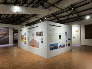
Figure 4. House of the Volcanoes content update and renovation.
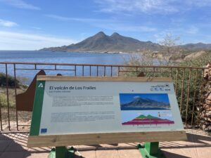
Figure 5. New geological information panoramic pannels (EN/SP).
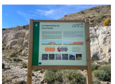
Figure 6. New complementary geological pannels (EN/SP).
- Highlight of the work carried out together with UNESCO through the Earth Sciences and Geoparks program, together with the European Geoparks Network (EGN) and the Global Geoparks Network (GGN) through digital publications, e-books, and promotional brochures, all accessible at the Cabo de Gata UNESCO Global geopark website.
- Specialized publications, among which the book Geology of the arid zone of Almería (Braga et al. 2003) stands out. The new Field Guide to the UNESCO Cabo de Gata-Níjar Global Geopark is in preparation and will be available during 2023.
- Conservation measures applicable to geosites, such as marking out trails, access restrictions in certain areas, restoration of geosites, and surveillance of main areas of greatest geological value and with a high influx of visitors during the summer season.
-Workshops on the geology of the Geopark, and conservation of the geological heritage. Among these, it is worth noting the European Geoparks Week and the Geopark in winter program. Established in 2018, it includes guided geological routes during the low season to boost dissemination in the Geopark. Collaboration with the University of Almería in the organization of the Geolodía (a national even celebrated jointly across Spain) when it is held in the Geopark, as well as with the Geological Society of Spain in the celebration of its Scientific Sessions, the Geopark being the venue for the last one held in December 2022 (Fig. 7).
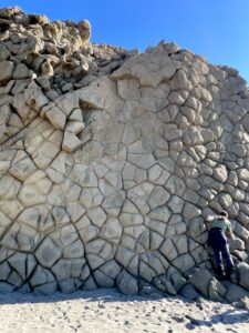
Figure 7. Columnar joint outcrop at Mónsul Coast Geosite during a scientific group visit.
- Design of the Map of Places of Geological Interest of Cabo de Gata- Níjar UNESCO Global Geopark, which includes a simplified geological map and list of all the geosites included within the territory of the geopark, as well as the new geological map of the updated geopark and geological studies of sedimentary and volcanic materials (separately), to be published during 2023.
- Collaboration with different universities that visit the geopark in terms of education, including assistance during field work, seminars, talks, etc.
- Collaboration with different organizations, such as universities, agencies, and associated centers in research.
- Monitoring of the Geopark area by rangers, across the territory, focusing on geosites with special influx of visitors and of fragile nature which have become an attraction for instagrammers and social media users.
Conclusions
During the COVID 19 emergency, conditions were difficult at all levels and mainly for the business fabric of the Geopark dedicated to tourism. As has happened worldwide, the paralysis of tourist activity dealt a severe economic blow to small businesses in the territory, with different administrations playing an important role in promoting recovery.
Thanks to the fact that protected areas have positioned themselves as major tourist destinations following the pandemic, in which visitors seek nature and open destinations, the Geopark's economic sector is gradually recovering, and as before the pandemic, visitation values have been reached during 2022 similar to 2019.
With the post-covid recovery, the UGG Cabo de Gata-Níjar maintains the tourist pressure of sea and sun (like other protected areas in the rest of the Mediterranean) and the increase in activity that implies the control of possible overexploitation of the aquifer and the agrological capacity of the soil. Efforts by the geopark management team focused on establishing a sustainable economic development model based on guaranteeing the preservation of the natural, cultural and geological heritage of the territory, ensuring that the local community feels identified with the territory and actively participates in its conservation.
The Geopark and its development program is positioned as the main tool to break the seasonality of tourist visitation and to raise awareness among the local population of the high geological, cultural, scenic, and ecological values, based on knowledge of the geopark's volcanic and reef origin and its evolution. Interest and curiosity on the part of the business community and the general resident population in the protection and conservation of the natural and cultural assets of the territory has increased, which is manifested in the participation of different sectors in all the activities proposed by Geopark.
The number of companies collaborating with the geopark (which includes ecotourism, geotourism, active tourism, HORECA sector, local producers of honey and vegetables and many more) is maintained, promoting training on the cultural and geological heritage for the enhancement of the territory, generating added value. This should be a fundamental tool to publicize the value of the place during the whole year.
The Geopark management team searches for international-level projects that involve other protected areas with similar characteristics, in which they can work jointly between local administrations, conservation associations, tourism promotion entities, the business fabric of the territory and other associations with an impact on the territory. The objective focuses on promoting development based on the conservation of the values of the territory, keeping in mind the efforts that we must all carry out against global change.