Introduction
La Cañada del Hornillo geosite is of great geologic interest and scenic beauty and is a regular destination for scientific research and environmental education activities in the Sierras Subbéticas UNESCO Global Geopark (Sierras Subbéticas UGGp; Fig. 1). The marine successions there record major episodes in the geological evolution of Western Tethys, in the southeastern margin of the Iberian microcontinent. In this area, type localities for several geological formations of the Betic Cordillera have been defined. Among the most interesting geological features of this Geopark, outcrops of the Ammonitico Rosso facies deserve special attention.
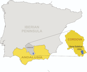
Figure 1. Location map of Sierras Subbéticas UGGp.
In addition, the Sierras Subbéticas UGGp limestone formations show well-developed karst features. Surface elements that include poljes, dolines, karrens, sinkholes and springs are common and diverse. Galleries in calcareous underground areas are well-known, and about 1000 caves and shafts have been inventoried in La Subbética district. The Sima de Cabra (Cabra Shaft), for example, contains exceptional historical milestones —the first documented cave rescue (1683) and the first documented scientific speleological exploration (1841) — leading it to be considered the cradle of modern speleology (Luque Valle 2015). Moreover, the abundance of karstic aquifers is of prime importance for the maintenance of nature and of numerous villages in the province of Cordoba.
The Ammonitico Rosso developed during the opening (rifting and drifting phases) of Tethys (Permian–Berriasian), especially in the areas characterized by complex paleogeography in a major part of what is now southern and middle Europe, yet less widespread in North Africa (see Fig. 2 and 3). There, the time range is typically Jurassic, while its record is locally diachronic; that is, the Ammonitico Rosso can represent different time intervals at different sites, even when physically very close. Within the Sierras Subbéticas, most Ammonitico Rosso facies developed during the Middle and Late Jurassic, though some can be traced to both the Early Jurassic and the Early Cretaceous. In the Ammonitico Rosso facies, the ammonites offer very high resolution biostratigraphy.
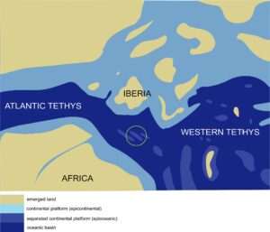
Figure 2. Western Tethys (colored) map during Kimmeridgian (Late Jurassic) showing major eco-sedimentary environments.
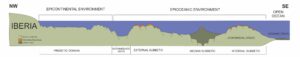
Figure 3. Major environmental framework accross the South-Iberian Palaeomargin. Adapted from Olóriz (2002)
Here, we introduce a case of an attack on the Ammonitico Rosso facies at the geosite La Cañada del Hornillo and the discovery of nearby ripraps recently constructed with very similar rocks. A thorough description of the importance of these facies and the information they yield is provided. Some considerations on the methodology for determining the origin of the rocks are presented. After this incident, a change in the Sierras Subbéticas Geoconservation Strategy is needed, and several related ideas are introduced.
Key Features of the Ammonitico Rosso Facies
The Ammonitico Rosso facies provides paleogeographic information about swell-areas (“haut fonds” or submarine high-bottoms; Fig.3) in the western Tethys during the Jurassic and Early Cretaceous. In addition, it records information about the evolution of marine species, ecosystems, and depositional dynamics, in a rather intricate stratigraphic record that has attracted continuous attention by geologists since the late nineteenth century.
The condensed character of the Ammonitico Rosso, as well as the high degree of fragmentation forced by block tectonics during its deposition, makes these facies extremely heterogeneous in time and space. Condensation favors changing environmental and depositional conditions from bed to bed, since variable intervals with erosion (mainly subaqueous), subsolution (subaqueous corrosion) and nondeposition (omission) take place. The heterogeneity of seabed orography throughout the paleomargin translates into heterogeneity of environmental and depositional conditions (light, oxygen, currents, living communities, sedimentation rate, etc.) across a range, from local to regional scale, so lateral changes of properties are characteristic of these facies.
Time and spatial changes are reflected in Ammonitico Rosso facies in such a way that every bed can be considered unique, with variables like chemical composition; bed shape and thickness; coloration; fossil richness, distribution, preservation, size and taxa registered; bed internal subdivisions and texture (type of particles, particle organization, bioturbation, post diagenetic diaclase network, etc.). All of this is related to differences in depositional and taphonomic histories resulting in variable stratigraphic condensation (thinner successions) and taphonomic condensation (time-averaging being involved).
The Geosite La Cañada del Hornillo
The GEOSITES project was launched in 1995 by the International Union of Geological Sciences (IUGS), supported by UNESCO, IUCN and ProGEO (Cleal et al. 1999). Its aim was to develop a global inventory of internationally significant geological sites. The first step was to define geological frameworks in every country, and then define contextualized geosites for each. Spain was one of the few countries that managed to complete the inventory of Spanish Geological Sites of International Importance (Igme, 2021), developed by the Spanish Geological Survey, in collaboration with the Spanish Geological Society (García-Cortés et al. 2001). The GEOSITES project was eventually abandoned, due to lack of consensus.
In early 2021, a new IUGS Global Geosites project was launched, this time adding the support of UNESCO Global Geoparks. To accomplish the worldwide inventory of geological heritage of international relevance, geological surveys, research institutions, and geoparks from all over the world will cooperate and contribute to a new IUGS Global Geosites inventory. This project, driven and coordinated by the International Commission on Geoheritage (IUGS), will define a new methodology and criteria towards an effective procedure (UNESCO 2021).
The Ammonitico Rosso Superior Formation (Molina 1987) of the Sierras Subbéticas corresponds to Ammonitico Rosso “calcaire” (Aubouin 1964), with interspersed horizons of red marly Ammonitico Rosso and red marly limestones, ranging in age from Middle Jurassic to earliest Cretaceous, Bajocian to Berriasian. It extends over 1,335.16 Ha within the Geopark limits, to represent 4.16% of the park’s total area. Sections in the Meridional and Septentrional External Subbetic include the boundaries of the Middle and Upper Jurassic stages, and the Jurassic–Cretaceous periods.
Since Verneuil and Collomb (1853, 1856), and especially after the stimulating contribution made by Kilian (1889), abundant studies carried out in this area have focused on biostratigraphy (see Fig. 4 for references), biostratigraphy combined with magnetostratigraphy and geochemistry (Ogg et al. 1984; Pruner et al. 2010; Coimbra et al. 2009), and even potential planetary interactions (Coimbra et al. 2015).
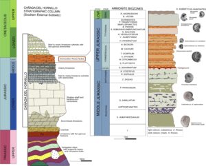
Figure 4. La Cañada del Hornillo stratigraphic column, and detail of the Ammonitico Rosso facies column, with the identified ammonite biozones. Ammonite specimens from the Sierras Subbeticas UGGp are placed in their corresponding biozone. The photographs have been extracted from Ph.D. theses by Olóriz (1976 publ. 1978), Sandoval (1983) Tavera (1985) and UGR collection.
La Cañada del Hornillo offers favorable conditions for obtaining an accurate "global" geologic correlation, supported by information from the Tethyan Ammonitico Rosso facies in conjunction with a combination of ammonite horizon biostratigraphic and magnetostratigraphic data. This approach was applied to the Kimmeridgian-Tithonian boundary at La Cañada del Hornillo and presented by F. Olóriz (2014) for the special GSSP Session “Stage Tithonian” of the 9th International Congress on the Jurassic System held at Jaipur (India). The data were gathered through an international collaboration research effort undertaken by A. Serna (Tragsatec-Sierras Subbéticas UGGp., Spain), F. Olóriz (RNM-178 J.A, Dept. Estratigrafía y Paleontología, UGR, Spain), and P. Schnabel and P. Pruner (Institute of Geology, Academy of Sciences, Czech Republic).
In particular, the Ammonitico Rosso facies from La Cañada del Hornillo provides data supporting: (i) biostratigraphic improvement of the west-Tethyan standard scale based on the recognition of stages, substages, biozones and biohorizons throughout the Middle Jurassic to lowermost Cretaceous stratigraphic interval (Fig. 4); (ii) the characterization of depositional conditions and their evolution related to a great variety of environmental conditions locally forced by the differential depth and dip of the seabed; (iii) the interpretation of fossil assemblages in ecostratigraphic terms, as well as the taphonomic processes determining their preservation; (iv) interpretation of the influence of currents on the seabed and their relations to event horizons; (v) changing paleoenvironmental conditions and early diagenesis based on chemostratigraphy (O and C isotopes); (vi) improved correlations based on magnetostratigraphy; (vii) integrative interpretation based on sequence stratigraphy; and (viii) attempts to identify orbital cycles more than 145 Ma ago.
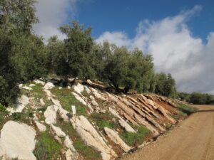
Figure 5. La Cañada del Hornillo geosite, in its Upper Jurassic part.
In addition to this array of data, the Ammonitico Rosso facies across La Cañada del Hornillo offers a variety of educational possibilities. The fact that fossils and particularly ammonites are common, together with the variable dips of bedding at the roadside, and the growth of olive trees over limestones with no visible soils (Fig. 5), lend this geosite a singular landscape. Indeed, it is possible “to view” organisms that inhabited Tethyan waters throughout a significant part of the Mesozoic (Figs. 6–8). Fossil remains are identifiable along the public track, making it unnecessary to walk onto private property. The stratigraphic succession of geologic formations along a single section in La Cañada del Hornillo allows for the identification of several major environmental changes affecting the South-Iberian shelf-system. Its evolution can be traced from epicontinental to epioceanic conditions —that is, there is evidence of the change from an epicontinental, shallow carbonate-shelf to its break-up during progressive westward rifting-drifting, and the concomitant structuring of the seabed in lows flanked by ranges of high swell-areas. The latter, showing a general longitudinal trend along the continental margin (Olóriz 2002, and references therein), are inhabited by pelagic and benthic organisms.
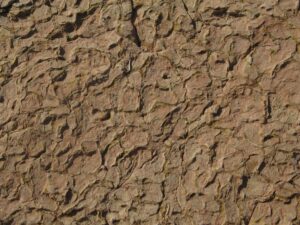
Figure 6. Detail of trace fossil (Thalassinoides) produced by the burrowing of ancient crustaceans throughout the marine sediment.
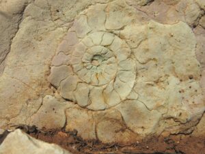
Figure 7. Erosion/omission surface affecting the inner cast of an ammonite carcass
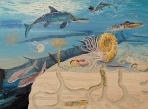
Figure 8. In communicating geological heritage, paleoenvironmental reconstructions are relevant tools, making scientific information more attractive for pupils, tourists, general readers, scientists or even politicians. The diorama shows a typical paleoenvironmental scenario for the Sierras Subbéticas during Late Jurassic times, with sea bottom conditions resulting in Ammonitico Rosso facies during the late Kimmeridgian Stage (Beckeri Biochronozone). High sea bottoms are typically separated by deeper areas across the paleomargin. At the forefront, crustaceans burrow new galleries (Thalassinoides) while they feed on detritus. Two primitive sharks of the Sphenodus type swim together. A living ammonite, Hybonoticeras harpephorum, which marks the relative age of this Biozone/Biochron, looks for food in the accumulated shells. A tiny hermit crab appears inside an ammonite shell. A shoal of belemnites is being attacked by two ichthyosaurs. Sea lilies (Isocrinus) rooted in the sediment capture food by their tentacles, while feather stars swimming in the water column do the same. Hermit crabs and Ichthyosaurus have not been found in Sierras Subbéticas but lived there during this period. Shark teeth have been recorded from Ammonitico Rosso facies in a swell range southwards in the paleomargin (the Internal Subbetic, Olóriz unpublished).
La Cañada del Hornillo is one of the four sections included in the Spanish Global s Inventory labelled as - “Ammonitico Rosso facies in the Subbetic Domain of Cordoba Province”, the other three being Puerto Escaño, Cortijo Beteta and Cortijo Fuente de los Frailes-Lanchares.
This geosite was defined in the internationally significant Spanish Framework “Pangea Rifting and Mesozoic Successions in the Betic and Iberic Cordilleras”. Given its highly scientific, didactic and touristic interest, the abundance and quality of outcrops, and its location inside a Natural Park and UNESCO Global Geopark, the protection of La Cañada del Hornillo is guaranteed by law.
At least five more sections of the Sierras Subbéticas district are expected to be added to this geosite in the near future.
Sierras Subbéticas Geoconservation Strategy
Ammonitico Rosso limestones have been extracted in the Sierras Subbéticas as an ornamental stone since Roman times, for the construction of floors, facades, columns, fountains, benches, drystone walls, drinking troughs, etc, although their use is not allowed anymore. Very remarkable Roman quarries are preserved in the geosite Cortijo Fuente de los Frailes-Lanchares. The most recent Ammonitico Rosso quarries closed a few decades ago, and the outcrops/sections where these facies occur are now protected.
The conservation of widely extended and interspersed lithofacies is a complicated task. Some 98% of the Sierras Subbéticas territory is private, and mostly unfenced. In fact, fencing or other construction affecting the landscape goes against Geopark’s philosophy.
La Cañada del Hornillo and other sites with Ammonitico Rosso facies are located by public paths and have free access. Moreover, many fossils occur scattered in the olive groves, thus encouraging visitors to wish to handle and collect specimens. However, the poor preservation of surface ammonites and the difficulty in extracting them provide some help in conservation. If the fossil is loose on the ground some will pick it up. Others may even try to extract one from the rock with no practice, and the fossil will break. Hence, some fossils show the marks of failed attempts at extraction.
For these reasons, the Management Body of the Sierras Subbéticas UGGp does not promote fossiliferous geosites for tourism. Instead, these sites are used for educational initiatives and scientific research. The Geoconservation strategy can be summarized in the following actions:
- Sierras Subbéticas Management Plan fulfilment. The territory is divided into areas according to three different degrees of protection. Even areas with the lowest degree of protection need authorization for any action proposal, then evaluation of the action is undertaken, resulting in permission or rejection depending on its impact on natural/ cultural heritage.
- Park Wardens training on geological heritage. Park wardens are agents of authority, and they guard the territory and ensure compliance with environmental regulations and, therefore, the conservation of natural resources. Wardens have been trained about geological heritage, and they learn the main types of rocks, fossils, geosites, and potential threats that affect them.
- Dissemination of geological heritage among social collectives. The geopark promotes the dissemination of geological heritage through organizing activities with schools, teachers, entrepreneurs, managers, visitors, publication of educational material, etc. These educational endeavors highlight the importance of geoconservation, and especially the vulnerability of fossils.
- No promotion of fossiliferous sites for tourism. These sites are exclusively restricted to scientific research, as well as to special visits and geopark educational activities after the introduction of appropriate ideas about geoconservation.
Under this strategy, no major damage has been observed at fossiliferous geosites. Isolated cases of vandalism can happen, although without identification of clear purpose in removing fossils.
Threats Affecting the Ammonitico Rosso Geosites
The importance of Ammonitico Rosso facies does not usually reside in local fossiliferous sites, like vertebrate sites, but rather on the succession of layers as a whole, hence the potential record of continuous and not necessarily gradual evolutionary change over time, based on the preservation of mainly discontinuous sedimentary records of variable time-averaging (mixing of organic remains). Outcrop extent and the abundance of fossils do not imply special measures against natural degradation. Yet some particular layers having exclusive features deserve protection against damage, such as the firm-to-hard ground surface showing well-preserved and iron encrusted networks of trace fossils made by arthropods (Thalassinoides; Fig. 6), which are better exposed at La Cañada del Hornillo than in the nearby sections.
Ammonitico Rosso facies occur in lower areas in the Geopark, where activities like agriculture (Fig. 9), livestock or scientific research are authorized. Despite the conservation strategy, several activities threaten the geological heritage, for instance when users act without formulating requests for pertinent permissions.
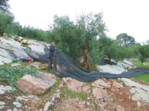
Figure 9. Agriculture is compatible with Ammonitico Rosso facies conservation, if established measures are fulfilled.
Agriculture:
- Burning of pruning products: direct fire on the carbonate rock blackens limestone, partially transforming it into lime, and destroying fossils or other features on its surface.
- The passing of heavy equipment: it scratches the surface of beds and breaks the rock.
- De-stoning farmland: removing rocks from fields causes destruction of strata and bedding, the loss of their original context, and a disorderly accumulation of stones on the margins of plots.
- Hole-digging for tree plantating: it produces breaks in the strata, or even their destruction.
Livestock:
Intensive livestock activity, with the continuous passing of cattle, can mean the breakage of semi-loose rocks and the scratching of stone surfaces, as well as the spread of dung and urine, which respectively hide surficial features and dissolve the rock, aside from causing a bad smell.
Scientific Research:
The damage produced on the rocks from fossil sampling or palaeomagnetic drilling is negligible when compared to the benefits that research work brings for science on a whole and the Geopark heritage. To conserve the beauty of the site, sampling at La Cañada del Hornillo trail is not authorized. However, it is permitted at an equivalent section located a few meters below, where the impact of sampling is less visible.
- Debris accumulation: The accumulation of debris after decades of palaeontological sampling can hide interesting features, such as rock surfaces and stratification. Temporary cleaning is promoted, since debris-free layers have a more striking appearance and favor precise observation, meaning enhanced information for the viewer.
An Attack against Geological Heritage in Sierras Subbéticas
In March 2019, damage at La Cañada del Hornillo was reported: several blocks of bedded rocks from the Ammonitico Rosso Superior Formation had been extracted using heavy equipment, and ammonite specimens that made the site spectacular had disappeared. At least 10 m2 of surficial features had been removed at six extraction points. The Nature Conservation Police (SEPRONA), together with park wardens and park technicians, went to the Geosite for evaluation in situ, and they discovered several newly built ripraps roughly 1 km away, presumably built using the illegally excavated rock (Figs. 10 and 11).
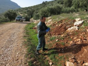
Figure 10. Nature Conservation Police (SEPRONA) officer taking photos for the investigation.
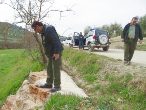
Figure 11. A recent riprap built with Ammonitico Rosso blocks was discovered by the Nature Conservation Police thanks to the orange-red color typical of this lithofacies.
Investigators took the following steps to determine if any of the Ammonitico Rosso limestone blocks used in the riprap construction corresponded to any of the blocks extracted at La Cañada del Hornillo geosite.
(1) Comparison between the shape of the excavation and previous photographs of the site to assess the damage. A large collection of photographs taken during recent years, as well as images on Google Street View were very useful for comparison of the site before and after the extraction, and estimation of the approximate size of removed rocks (Figs 12 and 13).
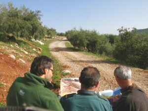
Figure 12. Comparison of photos to check the extent of damage.
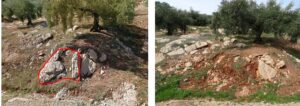
Figure 13. Photographs of one extraction point, before (left) and after (right) the removal of limestone blocks. Note that the slightly different view does not preclude the identification of correspondence.
(2) Characterization of the extracted blocks, from the most evident features to the most hidden ones, to ensure complete identification of the total volume of removed rocks. Shape and size are determined by (a) photographs taken before the extraction; (b) extraction damage in the field; and (c) features related to the precise lithologic analysis of the sedimentary layers remaining in situ —shape, size, thickness, color, and inner stratigraphic subdivisions. Based on the general coincidence of all these traits, details such as particular fossils on bed surfaces (seen in photographs) or specific microfacies features (e.g., textures, horizons with unique ferruginous oolites, lamination types, or microfossil contents not observed in other sedimentary layers [horizons with highly packed "filaments" (Callovian), globurigerinids (mainly Oxfordian), saccocomids (mainly Kimmeridgian-Lower Tithoniano), and calpionellids (upper Tithonian-Berriasian)]) can be determinants for reliable correlations.
(3) The gray patina that covers the exposed rocks can also be used to determine if the blocks in the construction were recently extracted, since newly extracted blocks show reddish coloration due to the terra rossa stain, while become progressively gray with time by direct exposure to weathering.
Unfortunately, the first step could not be carried out because the extracted blocks had been upended, showing only the freshly extracted bed bottoms (Fig. 14). Some blocks corresponded at first sight with the affected beds in La Cañada del Hornillo, but more precise studies are needed. In any case, soil was preserved on some block surfaces in one riprap. The fresh appearance of the concrete, the partial preservation of soil, and the red color of the rock surface all indicated a recent construction date.
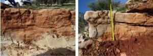
Figure 14. The Ammonitico Rosso block in the riprap (left) was set upside down. The in situ layer (right) that remained after the block extraction, shows similar characteristics to the riprap block in terms of dimensions, color, and equivalent irregular surface of stratigraphic discontinuity.
In fact, the owner of the ripraps was actually the owner of the geosite, which made this person the main suspect. He had failed to discuss his plans or obtain an authorization from the Management Body of the Sierras Subbéticas UGGp.
This attack on the Sierras Subbéticas UGGp geological heritage was published in local newspapers. The case is still under investigation. Sometimes the greatest threat against geological heritage stems from private land-owners, and may entail a lack of communication with the administration and a lack of heritage awareness.
Conclusions
The degree of damage at the geosite La Cañada del Hornillo stands as an unfortunate episode for Sierras Subbéticas UGGp, but it also creates an opportunity to learn and improve from the mistakes made and enhance preservation in the future.
This unfortunate event underlines the need for urgent change in the Conservation Strategy. The main initiatives considered are:
- Improved contact must be maintained with owners of land in or near the main geosites, to promote their awareness and understanding of the context, and heighten respect for the culture of natural conservation.
- Promotion of the program “Adopt a stone”, under the Spanish Geological Survey, a participative program that allows individuals to “become Godparents” of a Spanish geosite by carrying out very simple monitoring, once a year, with no financial contribution.
- Reinforced geo-conservation contents in education, as well as awareness programs and activities.
- Producing fossil casts for sale, more attractive than real specimens, in many establishments of the Geopark (Fig. 15).
Design of new tourist products broadly related to fossils, for instance La Cañada del Hornillo Bio-Extra-Virgin Olive Oil.
Figure 15. Ceramic pins made with clay from the Sierras Subbéticas by the association “El Barro Animado”.
Once the legal procedure is over, restoration possibilities will be considered.
In protecting the Natural Heritage, the main conclusion drawn by the Management of the Geopark is that more involvement on the part of Geopark inhabitants was needed, particularly landowners in and around the most important geosites.
Acknowledgments
This work is supported by Research Group RNM 178 (UGR-J-A): Evolución de los Márgenes Mesozoicos de Iberia. The authors acknowledge the daily valuable work of park wardens and the Nature Conservation Police in protecting natural resources in Sierras Subbéticas, particularly the geological heritage. Editorial guidance, and comments and suggestions by Dan Grigorescu and two anonymous reviewers are also acknowledged. Jane Sanders contributed to language revision