Introduction
Las Loras UNESCO Global Geopark (UGG) is situated in the north of Spain, in the south-eastern part of the Cantabrian Mountains, within the Autonomous Community of Castile and Leon, covering part of the north of Burgos and Palencia provinces (Fig. 1).
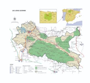
Figure 1. Geographical location of the Las Loras UNESCO Global Geopark-Map from Basconcillos Arce, J, from Las Loras Geopark Candidacy dossier.
In geological terms, the Geopark is located in the south-western edge of the Basque-Cantabrian Basin, within the so-called Norcastilian Platform (Floquet & Mathey 1984 and Barnolas & Pujalte 2004) (Fig. 2). The particular location of the territory at the edge of the sedimentary basin resulted in a complex paleogeographic evolution. In the Geopark there is therefore a strong representation of marine and continental fossils reflecting each of the succeeding paleoenvironments throughout the evolutionary process in this part of the basin, which lasted approximately 250 million years from its beginnings, during the Upper Permian, to the deposit of Miocene material in the intramountain basins generated after the Alpine Orogeny.
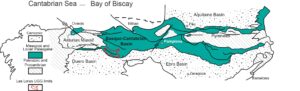
Figure 2. Situation of the Basque-Cantabrian Basin. Slightly modified figure from Barnolas and Pujalte (2004)
This rich paleontological heritage has not gone unnoticed by many of the residents of the territory and a special bond has been created. Fossils can be easily found decorating gardens or walls of houses in the region. There are also many examples of private fossil collections, which, as described below, are of high scientific and cultural interest to the territory.
The showcasing and protection of the geological heritage in the Geopark has been one of the main lines of work carried out by the Geopark team over the last years, even before its declaration as a UNESCO Global Geopark.
Social participation processes, which include geo-volunteering and small land custody programs, are being spearheaded by the Geopark as new models for geoconservation, promotion of natural and cultural heritage in the territory and empowerment of local people. In addition, the team is attempting to locate, list and value the “hidden” paleontological heritage found in several private collections in the area. Simultaneously, work has begun with local, regional and national administrations concerning protocols on paleontological heritage protection, for those areas of the Geopark, which are not included in any of the areas designated as Protected Natural Areas (PNA).
This paper aims to show the different management tools of a Geopark, which can be of great utility both in the conservation and showcasing of geological heritage, as well as in the empowerment of the local population and their commitment to heritage preservation.
Literature Review
In 2001, Victoriano Pujalte, Professor of Stratigraphy at the University of the Basque Country, stated in a report, used as a scientific endorsement for the development and setting up of Las Loras Geopark Project, the international importance of the territory’s geological heritage.
Furthermore, in the report commissioned by the Geopark to the Geological and Mining Heritage Department at the Geological Survey of Spain, Vegas et al. (2019) highlight that three of the 21 Spanish geological frameworks of international significance set in Law 42/2007 are represented in the Las Loras UGG territory. One of the three frameworks is the “Fossils and ichnofossils of the Continental Mesozoic in the Iberian Peninsula”, which is well represented in the Geopark. But as previously described, the complex paleogeographic evolution of the southern edge of this large sedimentary basin has resulted in a rich representation of marine and coastal environments throughout the whole region over its 250-million-year history.
Thus, several authors have stressed the paleontological wealth of the marine Jurassic in the Loras area. Examples are Pujalte et al. (1988) who describe 12 areas of ammonites in a Lower Jurassic formation and Quesada et al. (1990) who highlight the Dogger spongiolitic formations in this region. Regarding the continental Mesozoic, Hernández (2000) and Hernández et al. (1997, 1998) carried out research on the continental Upper Jurassic and Lower Cretaceous, and Diéguez et al.(2009) describe for the first time in Spain Tithonian-Berriasian fossil macroflora, pointing out its international significance because of its rarity at global level. One of the few discoveries of ornithopods in the Iberian Peninsula, in the Berriasian (Lower Cretaceous), is also described by Pereda Suberbiola et al. (2006), as well as a magnificent site of Lower Cretaceous Cycadeoidea fossil trunks (currently being investigated). In Figure 3 some of the most famous Geopark fossil records are shown.
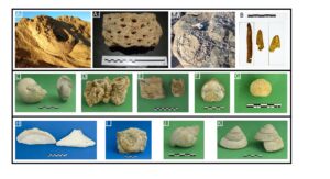
Figure 3. Some examples of key fossils from the Geopark. A1,2, 3) Berriasian Cycadeoidea fossil trunks. B) Cenomanian fossilized remains of leaves. C) Santonian nautiloids. D) Turonian Radiolites sp. E) Berriasian ornithopod vertebrae. F) Santonian Micraster sp. G) Campanian Cydaris sp. H) Bajocian Spongiaria I) Toarcian ammanoids. J) Santonian Tylostoma sp. K) Santonian Leptomaria sp.
Aware of this rich geological and, especially, paleontological heritage, from its beginning the Geopark Project set out as the main objective that it would involve local people in the management of their heritage. This would be through citizen participation, understood as a social practice by which citizens contribute to politics, or in this case, to aspects of natural and cultural heritage in their territory (Bustos et al. 2018).
The idea of collecting and combining different fossil collections, and emphasizing their value for educational and informative purposes, is not new (Canudo 2017) and there are different examples on a national scale which show that this type of action aids the protection of geological heritage, the empowerment of the local population, awareness raising and also as a resource for the sustainable development of the territory (Castanera et al. 2017; Alcalá & Cobos 2017).
Method
The methodological basis used over the years can be summarized by the following processes.
1. Literary research and interviews with researchers. First, a literature review was undertaken of the scientific publications related to the Geopark and its surrounding areas to understand the region better and to begin to locate the most important features of natural and cultural heritage. At the same time, contact was made with researchers who had worked within the Geopark, and who are currently part of its Scientific Committee, in order to obtain detailed information about the outcrops and paleontological sites.
2. Inventory and mapping of sites of geological interest and interviews with local people. The next step was to compile an inventory of sites of geological interest, in which several sites of paleontological interest were included. Several interviews were carried out with local people to locate some of the paleontological sites. Initial mapping was carried out to locate the sites of interest. As a result of the fieldwork and especially of the interviews with local people, several undisclosed private collections were discovered.
The following parameters were included in the initial inventory: Name of site, Identification code, Location, Municipality, Geological interest (paleontological, stratigraphic, geomorphological), Main use (educational, scientific, tourist), Value (international, national, regional and local), UTM coordinates, Brief description, Interpretation material (panels, leaflets, guides) and Level of protection.
Criteria for scientific evaluation of the geosites were related to the evaluation of the relevant scientific literature for each of the sites. The designation of sites of international relevance in Las Loras UNESCO Global Geopark was established through the Global Geological Framework. Three of the frameworks of international relevance are present in the Geopark: karst systems in carbonates and evaporites of the Iberian Peninsula and the Balearic Islands; Pangea rifting and Mesozoic successions of the Betica and Iberian mountain ranges; and fossils and ichnofossils from the continental Mesozoic of the Iberian Peninsula.
3. Inventory and description of the private collections. Once the private collections were located and after several meetings with the owners in which a relationship of trust was built, we gained access to them to make an initial description of their conditions and possible scientific, educational and tourist value (Fig. 4). We noted the number of specimens, their conservation condition, collection site, name of collector, and other data. Three of the inventoried collections were assessed as being of high educational and touristic value. One in particular also showed high scientific and cultural significance as it included detailed information about where the fossils had been collected, spectacular field notebooks, drawings of each of the fossils (Fig. 4) and even an attempt at taxonomic classification.
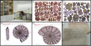
Figure 4. Inventory and characterization of private collections and some examples. A) Working at the Geolab. B and C) Mural-plates "Life in the Cretaceous Seas" by José María Fernández Manjón. D and E) Examples from José María Fernández Manjón's field notebook with descriptions and determinations of the specimens. F) Photograph of one of José María Fernández Manjón's documents attached to each specimen in his collection, with information on the place and date where it was collected and reflections and hypotheses for the formation and presence of these fossils in the territory.
4. Creation and galvanization of working groups. The next step was the creation of citizen participation working groups, in which all sectors of an essentially rural society were represented. As noted already, the aim was to involve the population in the management of their heritage. This was done by integrating the working groups in a yearly action plan, annual evaluations of this plan, and in physical work at the sites by geo-volunteers. The implementation of these geo-volunteering actions has probably been one of the most powerful and successful tools in terms of results, in relation to protection and showcasing of the natural and cultural heritage of the Geopark, and the empowerment of the local population. They also serve as an indicator of local commitment to the Geopark activities. Thus, in the first year of geo-volunteering, in 2013, 15 people participated. The number of participants has notably increased year after year and reached a total of 481 volunteers over the last eight years. Taking into account the population of the Geopark, which is scattered and largely elderly, this can be considered as a great success.
Results
Since our subject matter is geological heritage and more specifically paleontological heritage, only these two features are to be referred to.
Work and Results for the Protection of Paleontological Heritage
- Meetings with politicians responsible for natural heritage in Castile and Leon in order to start working on specific protocols for the protection of geological heritage. As a result of these meetings and after the declaration of the territory as a Global Geopark, the designation of the Protected Natural Areas of Covalagua and Las Tuerces as Protected Landscapes and Natural Monuments was speeded up.
- Work developed with the directors of the Protected Natural Areas located within the Geopark. As a result of this collaboration a network of public trails and geo-routes in Covalagua PNA was created and work is in progress in Las Tuerces PNA. (https://www.diputaciondepalencia.es/noticia/20180418/visita-espacio-natural-covalagua-conocer-actuaciones-sus-sendas). https://patrimonionatural.org/documentos/listado?search%5Bkey%5D=covalagua&search%5Bcategory%5D=#search).
- Protection and recovery works for a Lower Cretaceous Cycadeoidea trunks site in collaboration with regional administration and the Geological Survey of Spain. Surveillance work was carried out at the site, which was exposed when the water level of the reservoir in which it is found had receded. As for protection and recovery of the site with the Geological Survey of Spain, only one initial assessment could be made in situ, as, following the drought of 2018, a period of rainfall led to a rise in reservoir water level and consequent flooding of the site.
Actions for Showcasing and Dissemination of Paleontological Heritage
- Construction of the “Geopark Centre 2 5 0. Geology and Palaeontology” in Villadiego. The center is focused on enhancing and promoting geology and paleontology in the Geopark. The center offers a tour through the geological history of the territory as well as paleontological workshops at its Geolab.
- Work on restoration, description and evaluation of both fossils and documents given to the Geopark by private collectors. Cataloging and restoration work of an important collection donated to the Geopark after its owner’s death are currently being undertaken.
- Agreements with collaborators and private collection owners for use of their specimens in paleontological exhibitions and displays. Several exhibitions have already taken place with the collaboration of several collectors. Moreover, the Geopark has granted a small collection of fossils for a permanent exhibition at one of its collaborating museums, the Petroleum Museum in Sargentes de La Lora.
- Educational workshops on paleontology at different trade fairs and educational centers. To promote the Geopark’s paleontological heritage, several workshops have been held, using part of the private collections given to the Geopark.
- Geotourism. Several geo-trails have been designed and signposted, according to the inventory of sites of interest and the different uses assigned to each one in their descriptions, taking into account their vulnerability as well as their educational and touristic potential.
Actions towards the Empowerment of Local People Related to Palaeontological Heritage
- Geo-volunteering (Fig. 5). Local people have participated in the creation of the inventory and description of some of the Geopark’s sites of geological interest, as well as fieldwork activities and debates about the best uses for each of those sites. The intention of the geo-volunteering activities is not only to recover sites of geological interest but also to involve local people in their management, and therefore in the actual management of the Geopark. It is worth stressing that custody and monitoring agreements for some of the sites of interest came from geo-volunteering activities.
- Carrying out interviews and reports for press and television media (Fig. 5). The news about the paleontological heritage of the Geopark and about the local people serves a dual purpose. It both promotes the value of such heritage and increases a sense of pride and belonging to a territory among the local population.
- Visibility of local people within the activities carried out in the Geopark (Fig. 5). Special attention has been paid to giving a greater say to local people collaborating with the Geopark and participating one way or another in activities related to paleontological exhibitions, both in the Geopark Visitor Centre and in associated museums and exhibition spaces. Likewise, some of these people play a special role both in publications (Basconcillos et al. 2018) and videos, as well as in important events developed or organized by the Geopark, such as the evaluation and revalidation processes for the incorporation and maintenance of the territory in the UNESCO Global Geopark Network and meetings of the Spanish Geoparks Forum, among others.
School Student Training Program
- Field trips and workshops (Fig. 5). Within the Geoeducation schools program, several field trips were organized to explore some of the paleontological sites. Further, several paleontological workshops were held so that students could familiarize themselves with the most representative fossils in the Geopark.
Discussion and Conclusions
In2004, work began to showcase the value of the territory’s geological heritage, later designated as a UNESCO Global Geopark in 2017. Most of the work has been directly related to the protection, dissemination and enhancement of the paleontological heritage.
During the creation of the initial inventory of sites of geological interest, several people were found to own private collections of fossils, some of which had a high scientific, educational, artistic and cultural value. Working with these people has led to collaboration agreements and permanent donations of some of the collections to the Geopark. The involvement of these people in many of the activities related to the promotion of the Geopark has proved to be a powerful tool for the protection of paleontological heritage and the empowerment of local people, leading to custody agreements of sites of interest and an increase in the sense of belonging to a territory once forgotten (Fig. 5) but which currently is of great relevance both in the media and in the increasing amount of public investment in recent years.
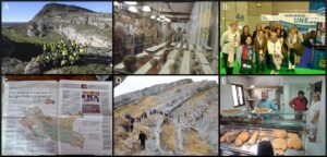
Figure 5. Geopark and local population. A) Geo-volunteering for the conditioning and enhancement of a place of geological interest (Cueva del Agua sinkhole in Basconcillos del Tozo). B) Local population in Geopark activities: (B1) Paleontological exhibition of fossils transferred to the Geopark from a private collection. (B2) Visit of a group of people from the territory to the stand of the UNESCO Global Geoparks Network at the International Tourism Fair (FITUR). C) Photograph of a report on the Geopark in a regional newspaper. D) Didactic geo-route with schoolchildren. E) Geo-bakery in Basconcillos del Tozo.
Acknowledgments
We thank all the inhabitants of our Geopark who participate and collaborate in each of the actions and projects that we develop. Also, thanks to the Provincial (Burgos and Palencia) Councils, Local Development Groups and Entretantos Foundation for their support.
Conflict of Interest
The authors declare that there is no conflict of interest in their work