Introduction
The recognition that there were geological features and sites in the United States worth protecting legislatively for future generations has a long history, beginning with the designation of Yellowstone National Park in 1872. At the same time, the first beginning of a recognition that geological heritage required protecting was taking root also in the United Kingdom and Germany (Burek and Prosser 2008). Since then, the idea of geoconservation has spread internationally, with the growth of geotourism and the designation of geoparks and geosites (see articles in Burek and Prosser 2008; Errami et al, 2015; Hose 2016; Reynard and Brilha 2018). In the United States, geoconservation is the responsibility of the federal government (national monuments, national parks, national natural landmarks), state governments (state parks), cities (city parks), and individuals (part of the national natural landmarks) (see Table 1).
Table 1. Responsible agencies for geoconservation sites in the United States.
Agencies for Geoconservation |
National monuments: federal |
National parks: federal |
Natural national landmarks: federal and individual |
State parks: state |
City parks: cities |
Among the geoconservation units in the United States, the National Natural Landmarks (NNL) are not widely known. These conservation sites are selected for their outstanding biological and geological resources of scientific and educational value. Sites are designated by the U.S. Secretary of the Interior on the recommendation of the U.S. National Park Service, which works cooperatively with landowners. Because NNL include both private and public land, participation is voluntary ("public lands" are lands under the control of the federal government for the public). The program was established by the then United States Secretary of the Interior Stewart Udal on 18th May, 1962 to encourage preservation of specific areas deemed too small for national park or national monument status. There are currently 599 NNL in 48 states, American Samoa, Guam, Puerto Rico, and the U.S. Virgin Islands. In the state of Colorado, there are 15 National Natural Landmarks, including Garden Park (Fig. 1).
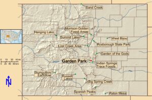
Figure 1. National Natural Landmarks in Colorado, USA. Most of these may be considered geological or paleontological geoconservation areas.
The Garden Park National Natural Landmark (GPNNL) constitutes about 13 square kilometers (3,209 acres) of public land approximately 11 km (7 miles) north of Cañon City, along the Front Range of the Rocky Mountains in central Colorado (Fig. 2). The land is managed by the Royal Gorge Field Office (RGFO) in the Rocky Mountain District of the Bureau of Land Management (BLM). The BLM is one of the four major federal land management agencies in the United States, the others being the National Park Service, the Bureau of Reclamation, and the U.S. Forest Service.
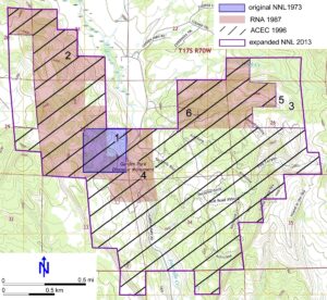
Figure 2. Fossil sites and changing designations for areas in the Garden Park Fossil Area. 1, Marsh-Felch Quarry; 2, Cope-Felch Quarries; 3, DeWeese Quarry; 4, Cleveland Museum of Natural History Quarry; 5, Lindsey Quarry; 6, Small Stegosaurus Quarry. See Appendix 1 for content of sites. Abbreviations: ACEC = Area of Critical Environmental Concern; NNL = Natural National Landmark; RNA = Research Natural Area. Data from Decker 2012.
Our aim here is to present the story of the Garden Park NNL, representing an example of geoconservation that has wider implications in terms of the long history of scientific discovery, coupled with public interest in paleontological and geological research. Further, it offers a story of environmental decline of the fossil area, the recognition of its historical and paleontological significance, federal legislation to salvage the area, and ultimately, its rejuvenation.
Materials and Methods
The paper is based on the personal knowledge of the authors, reference to published literature, but importantly also the use of unpublished archives. These include the correspondence of Benjamin Mudge and Marshall Felch to O.C. Marsh of the Yale Peabody Museum, which are available at https:// peabody.yale.edu/collections/vertebrate-paleontology/correspondence-o-c-marsh. Bureau of Land Management documents for Garden Park are housed at the Royal Gorge Field Office, Cañon City, Colorado and online at the BLM Library at https://archive.org/details/blmlibrary/ and https://www.handsontheland.org/garden-park/; and Google Books https://books.google.com/.
Geographical and Geological Setting
Garden Park is a 19.5-kilometer-long (12 miles) linear valley between the eastern and western escarpments of the Fourmile Graben about 11 km (7 miles) north of Cañon City, Colorado (Wobus et al. 1985). The valley is bisected by Fourmile Creek (formerly Oil Creek), which has its headwaters near the old mining town of Cripple Creek, and which drains into the Arkansas River on the east side of Cañon City. Erosion of the hogback developed along the southern margin of the Pikes Peak Massif by Fourmile Creek has exposed the Upper Jurassic Morrison Formation strata in the escarpment walls (Figs. 3, 4). The softer Morrison Formation is protected by the more resistant overlying Upper Cretaceous sandstones of the Lytle and Glencairn formations that form the skyline.
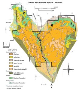
Figure 3. Surface geologic map of the Garden Park Natural National Landmark (heavy black line) and location of the main dinosaur sites. 1, Marsh-Felch Quarry; 2, Cope-Felch Quarries; 3, DeWeese Quarry; 4, Cleveland Museum of Natural History Quarry; 5, Lindsey Quarry; 6, Small Stegosaurus Quarry.
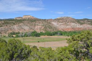
Figure 4. Morrison Formation as exposed on the west side of the Garden Park National Natural Landmark. The low red conical hill is the site of the main Cope-Lucas Quarries.
Historical Setting
Large numbers of settlers began arriving in Colorado during the Pikes Peak Gold Rush (1858–1861) and by 1859 Cañon City was established (Binckley and Hartwell 1879). Oil was found near the mouth of Fourmile Creek (then called Oil Creek) canyon in 1860, which led to the production of a small petroleum distillery that sold refined oil throughout Colorado (Kupfer 2000). Settlers moved into Garden Park in 1862, drawn by the valley's agricultural soil. After the Civil War (1861–1865), several new families moved into Garden Park, two of which would play important roles in the early discovery of dinosaurs. Aaron (1835–1917) and Lucy (1841–1918) Ripley acquired a homestead in the Park, and war veterans Marshall (1834–1902) and Amanda (1833–1893) Felch bought a homestead about two kilometers (1.25 miles) further south.
The scientific importance of Garden Park began with the 1877 discovery of dinosaur bones at several sites. The story has been well discussed, especially their role in the infamous "Bone Wars" between O.C. Marsh (1831–1899) of Yale University and E.D. Cope (1840–1897) of Philadelphia (e.g., Osborn 1931; Schuchert and LeVene 1940; Shor 1974; Colbert 1968; Spalding 1993; Monaco 1998; Jaffe 2000; Thompson 2008; Carpenter 2019). The most scientifically important sites (Figs. 2, 3) are briefly summarized and their fossil contents listed in Appendix 1.
Marsh-Felch Quarry. This site was apparently found by Sarah Felch (1867–1928), daughter of Marshall and Amanda, in the spring of 1877 (Grenard, in preparation). The site was reported to Benjamin Mudge (1817–1879) in August 1877 when he arrived to investigate the newspaper reports of large bones being found (see Carpenter 2019). Mudge, aided by Samuel Williston (1851–1918), both representing O.C. Marsh of Yale University, hired and trained Marshall Felch to assist in the excavation for several months (Evanoff and Carpenter 1998). Several years later, Felch resumed excavating for Marsh (Fig. 5A, B) and shipped tonnes of specimens to Yale (1883–1888). From this quarry, Marsh named the large carnivorous theropod dinosaurs Allosaurus fragilis and Ceratosaurus nasicornis, the long-neck sauropod Diplodocus longus, and the large, plated stegosaur Stegosaurus stenops. The quarry provided some of the first nearly complete dinosaur skeletons, the first complete dinosaur skulls, and the first fossil mammal from the Morrison Formation (Evanoff and Carpenter 1998). All specimens collected after 1883 are at the Smithsonian Institution and some are on display (Fig. 7A–D). The quarry was reopened by the Carnegie Museum of Natural History in 1900 by William Utterback (born 1842, death year unknown) under the direction of paleontologist John Hatcher (1861–1904). Two partial skeletons of the sauropod Haplocanthosaurus priscus were excavated.
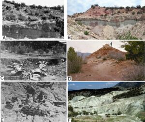
Figure 5. Past and present appearance of the dinosaur quarries in the GPNNL. A, Marsh-Felch quarry in 1888 and B, today; C, one of the Cope-Lucas quarries showing Camarasaurus skeleton as found and D, same site today; E, DeWeese Quarry in 1916 and F, today (lower right). Photographs courtesy of the BLM RGFO.
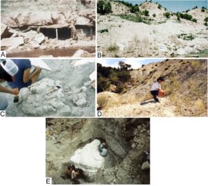
Figure 6. Past and present appearance of the dinosaur quarries in the GPNNL. A, Cleveland Museum of Natural History Quarry in 1956 and B, today; C, Lindsey Quarry around 1980 and D, today; E, Small Quarry in 1992. Photographs courtesy of the BLM RGFO.
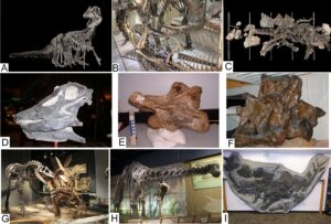
Figure 7. The paleontological significance of the GPNNL is attested by some of the scientifically significant specimens. Marsh-Felch quarry includes: A, Allosaurus; B, Ceratosaurus; C, Stegosaurus; and skull of Diplodocus (images A–C courtesy of the Smithsonian Institution). Cope-Lucas specimens includes: E, a cervical vertebra and F, sacrum of Camarasaurus (images courtesy of Takehito Ikejiri). G, Kessler Stegosaurus; the land from which the specimen was collected is the last major parcel yet to be acquired for the GPNNL. H, Haplocanthosaurus skeleton from the Cleveland Museum of Natural History Quarry (image by Scott Robert Anselmo, Wikimedia, Creative Commons license); I, cast of the small Stegosaurus as found (image by Toni Culver).
Cope-Lucas Quarries. Oramel Lucas (1849-1935) moved from Ohio in June, 1876 when he was hired as school teacher for the one-room school in Garden Park. This job was arranged by his sister Lucy Ripley (Carpenter 2019). In April 1877, he discovered large bones that he soon sold to E.D. Cope of Philadelphia. It was the newspaper reports of these bones that prompted Marsh to send Mudge to Garden Park (see Carpenter 2019). Cope hired Oramel and his brother Ira (1838-1920) to work a series of sites from 1877–1884. The main sites clustered around a low, conical hill known today as "Cope's Nipple" (Fig. 5C, D; Carpenter 2019). Cope named several new taxa, of which the sauropod Camarasaurus supremus was represented by several partial skeletons. Most of the Cope collection was purchased by the American Museum of Natural History, New York after Cope's death, but a few Camarasaurus bones were sold to the Wagner Free Institute of Science in Philadelphia. Most of the Lucas specimens are in storage (Fig. 7E, F). The main quarries at Cope's Nipple were reopened by the Carnegie Museum of Natural History in 1901, but little was found (Carpenter 2019).
DeWeese Quarry. In 1915, a local businessman and hunter-naturalist, William Dallas (Dall) DeWeese (1857–1928), found what proved to be the rear portion of a Diplodocus skeleton on the east side of Garden Park (Fig. 5E, F). The specimen was excavated in 1916 with the financial assistance of the Colorado Museum of Natural History (now the Denver Museum of Nature and Science), where it now resides in the collections (Monaco 1998).
Kessler Quarry. One quarry of historical importance that is not currently within the GPNNL is the Kessler Stegosaurus Quarry (see further discussion below). Named for a local high school teacher Frederick C. Kessler (1883–1963), he and his students discovered a nearly complete Stegosaurus skeleton during a field trip in 1937 (Carpenter 2002). They assisted the Colorado Museum of Natural History in excavating the specimen, which was mounted for display and became the state fossil of Colorado in 1982 (Fig. 7G). This quarry is not included on Figures 2 and 3.
Cleveland Museum of Natural History Quarry. A report of dinosaur bones brought Edwin Delfs from the Cleveland Museum of Natural History to Garden Park in 1954 (Carpenter 2002). Delfs led a three-year excavation (Fig. 6A, B) that resulted in a large sauropod skeleton that was mounted for display and later named in his honor, Haplocanthosaurus delsfi (Fig. 7H; Monaco 1998).
Lindsey Quarry. A partial Camarasaurus grandis was accidentally uncovered near a bentonite mine (Carpenter 2002; Fig. 6C, D). The specimen was excavated over the course of several years in the early 1970s by the Denver Museum of Natural History and now resides in the collections there. None of the material is on public display.
Small Stegosaurus Quarry. In the early 1990s, the Denver Museum of Natural History began a multi-year survey of Garden Park, which resulted in the discovery of another Stegosaurus skeleton in 1992 (Fig. 6E; Carpenter 1998, 2019). This specimen played an important role in the later development of the GPNNL as discussed below. Casts of the specimen are on display (e.g., Fig. 7I). The site is about 230 m upstream of the Kessler Stegosaurus along the same ephemeral stream.
The Bureau of Land Management and Garden Park
The roots of the Bureau of Land Management (BLM) go back to 1812 when the General Land Office (GLO) was created to survey and dispose (selling or giving away) of public domain in the western territories. This land was disposed to settlers, towns, new states entering the Union, railroads, private companies, agricultural and mechanical colleges and universities, and to other federal land management agencies (Bureau of Land Management 2018). Management of land was not a mandate of the GLO and as a result, much of the western landscapes under their authority degraded over time due to overgrazing by cattle and sheep. The 1934 Taylor Grazing Act attempted to improve rangelands by regulating grazing of the unappropriated public domain. Oversight of the Grazing Act was given to the newly created Grazing Service within the Department of Interior. In 1946, the General Land Office and the Grazing Service were integrated into a new federal agency termed the Bureau of Land Management (Muhn and Stuart 1988). This agency is responsible for management of timber, rangelands, minerals, cultural resources, and air quality for about 246 million acres (995,527 sq. km) of public land primarily in the American West, and 801 million acres (3,241,532 sq. km) of federally owned minerals (Bureau of Land Management 2018). Unfortunately, prior to 1976, public land management was ineffective because the role of the BLM was not well defined, and the environment was seriously degraded by that time.
The environmental degradation of Garden Park actually started as soon as settlers arrived around 1862 and began altering the landscape. The oil drilling and oil processing along Fourmile (also known at the time as "Oil") Creek in 1862 and sporadic drilling until the early 1980s added to this degradation. The impact on the paleontological resources by people was first reported by Marshall Felch in a letter to Professor Marsh (November 22, 1885): “since the first of Sept. when the large humerus came near being ruined by a party of young people from Canon one Sunday – we have not left the quarry alone on Sundays – but have taken turns in watching the grounds constantly.” An even worse incident was reported by Felch to Marsh several years later when fossils at another nearby site were vandalized (Felch, February 10, 1891, letter to Marsh).
The damage to the environment and paleontological resources of Garden Park increased dramatically in the 1950s in large part because of the proximity of the area to Cañon City. The origins of this damage were identified by Berta (1984, 1988) and can be grouped into four major causes:
Casual collecting. Amateur rock and fossil organizations aided by collecting guide-books and even small businesses guided visitors to collecting locations. In combination with the sale of surface rock, this collecting stripped some areas of all surface fossils. Historic metallic materials such as nails, tools, etc. at the old quarries were also removed by visitors using metal detectors.
Grazing. Until grazing districts were established after 1934, free or open range practices allowed unrestricted grazing by sheep or cattle, leading to soil erosion, invasive weeds, and a general degradation of the land.
Mining. The area near the DeWeese and Lindsey quarries in an area called "Green Acres" was an open-pit bentonite mine, which produced clays that were sold for pond lining because the expansive clay was well suited to prevent leakage of stock ponds (Fig. 8A). Uranium prospecting in the 1950s and 1960s had a major impact on the exposures of the Morrison Formation on the south end of Garden Park. A common practice was to use a bulldozer to scrape away the topsoil and a following worker would use a Geiger counter to look for radioactive hot spots. Dinosaur bones often have low levels of radioactivity and may have been hauled off as ore.
Recreation. The proximity of the underdeveloped south end of Garden Park to Cañon City made it an ideal recreational playground. These activities included Off-Highway Vehicles (OHV: jeeps, pickup trucks, dirt bikes) and target shooting. Dirt bikes became especially damaging by driving over historic dinosaur quarries and fossils (Fig. 8B) and because new trails could easily be established through repeated use. Local residents discarded large appliances and other trash, which were then used for gun target practice. Another popular activity was “mudding,” the practice of driving in circles through meadows after a rainstorm thereby damaging the top-soil and native plants.
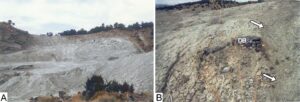
Figure 8. Degradation of the Garden Park area includes A, a bentonite mine and B, dirt bike trail (arrows) across a portion of dinosaur bone. Photographs courtesy of the BLM RGFO.
Recognition of Paleontological Significance of Garden Park
Interest in the dinosaur bones uncovered in Garden Park was immediate once Lucas announced his discovery, with local townspeople arriving to see the bones for themselves (Fig. 9A). Despite the long historical recognition that Garden Park played an important role in the early history of dinosaur paleontology in the United States, formal recognition was slow. In 1953, the State Historical Society of Colorado and the Cañon City Geology Club placed a small rock monument near the Marsh-Felch Quarry, with a plaque describing the significance of the area (Fig. 9B). The plaque contains inaccurate paleontological information, but it is important as a display of the first community recognition of the significance of Garden Park. Further recognition came in November 1973, when 40 acres (0.16 sq. km) of land that included the 1953 monument were designated as a NNL (Fig. 2). This small area was chosen so that the public could see the Marsh-Felch Quarry, but not walk onto the site, which was in private ownership at the time.
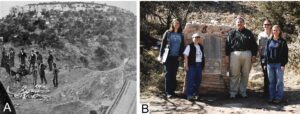
Figure 9. Local community interest in dinosaur sites in Garden Park is demonstrated by A, an 1877 photograph by C.W. Talbott, a photographer from Cañon City, Colorado at one of the Cope-Lucas Quarries. B, Left to right: Allison Vitkus, Karin Decker, Harley Armstrong, Melissa Smeins, Heather Germaine standing by historic monument in 2011
Table 2. Former and current Bureau of Land Management classification systems for surface geology based on the potential that significant paleontological resources occur in a geologic unit.
Former Classification (pre-2015) | Potential Fossil Yield Classification (current) |
Class 1. These areas have documented localities that contain vertebrate or other fossils with important scientific value. | Class 5 – Very High. Highly fossiliferous geologic units that consistently and predictably produce significant paleontological resources |
Class 4 – High. Geologic units that are known to contain a high occurrence of paleontological resources. | |
Class 2. Lands within geologic formations or members of formations that have produced fossils of scientific value elsewhere. | Class 3 – Moderate. Sedimentary geologic units where fossil content varies in significance, abundance, and predictable occurrence. |
Class 3. Lands that have low potential for the discovery of fossils of scientific value. | Class 2 – Low. Geologic units that are not likely to contain paleontological resources. |
Class 4. Lands that have negligible potential for the discovery of fossils. | Class 1 – Very Low. Geologic units that are not likely to contain recognizable paleontological resources. |
Recommendation of Garden Park to become a NNL came from two studies commissioned by the NPS. The first was by Yale University paleontologist John Ostrom who assessed 130 dinosaur sites around the United States, but only recommended 19 for NNL status, including Garden Park because of its historical importance and as the source of large collections of dinosaurs (Ostrom 1970). Ostrom's recommendation for Garden Park was corroborated by an additional study specifically of Garden Park by University of Wyoming paleontologists Paul O. McGrew and Michael W. Hager (1972).
Unfortunately, aside from placing Garden Park into the national registry of Natural National Landmarks, the environmental degradation of Garden Park continued because the BLM had little knowledge or appreciation of the paleontological resources and it had no specific mandate to manage them. All of this began to change after the passage of the Federal Land Policy and Management Act (FLPMA) of 1976. FLPMA mandated several key points that the BLM had to consider in its management of public lands, including the GPNNL, namely:
Multiple Uses. Lands had to be managed with multiple uses in mind, including mining, oil and gas development, grazing, and recreation. Thus, the mandate for the BLM is different from the National Park Service in which protection of the land is primary. In Garden Park, the BLM allows grazing and recreation (camping, hiking, OHV on established trails, mountain biking, and target shooting in a restricted area), all while protecting the paleontological resources.
Unnecessary and Undue Degradation: The BLM was required to prevent unnecessary degradation of the public lands that might result from mining and mineral exploration that are conducted under the Mining Law of 1872. Under FLPMA, the BLM can restrict mining in Garden Park which might impact the paleontological resources.
Nonrenewable Resources. Dinosaur fossils are considered a nonrenewable resource because dinosaur fossils are no longer being made; once destroyed, they are gone forever. This term helped drive BLM policies today regarding paleontology into the future.
Special Management Areas. FLPMA not only described how public lands were to be managed, it also enabled more care and protection of some areas. These areas were identified by the BLM with public input through the resource inventory and designated Areas of Critical Environmental Concern (ACEC: areas "where special management attention is required to protect and to prevent irreparable damage to important historic, cultural, or scenic values, fish and wildlife resources, or other natural systems or processes, or to protect life and safety from the natural hazards"), Research Natural Areas (RNA: areas "established and maintained for the primary purpose of research and education"), or Outstanding Natural Areas (ONA: "areas of outstanding scenic splendor, natural wonder, or scientific importance that merit special attention and care in management to insure their preservation in their natural condition"). Garden Park, for example, was designated as an RNA in 1988 because of the many scientifically important fossils recovered and the potential that others remain to be discovered, and because of the rare brandegee buckwheat (Eriogonum brandegeei) plant.
Inventories. In order to manage the value of its sites on public lands, BLM was required to conduct inventories of resources so that it had a clear understanding of what these were and how to manage them. The resources included important historic or cultural sites, areas with scenic value, fish and wildlife, native plants, and scientifically important fossils (FLPMA, Title II, Section 201). Once the resources were identified, a Resource Management Plan (RMP) was created to ensure that management of the resources would be environmentally sound (i.e., in compliance with the National Environmental Policy Act of 1970) and that the public had an opportunity to provide feedback through open meetings and comment periods.
The Royal Gorge Field Office (RGFO) contracted for several different paleontological inventories beginning in 1979. The first two (Fischer 1979; Lindsey and Westlye 1982) were very broad in scope and ranked formations in the northern portion of the Royal Gorge Resource Area into one of three categories (Table 2). Garden Park was identified in both reports as a Class 1 area because of the known scientifically important dinosaur localities. A more specific inventory limited to Garden Park (Lindsey 1983) gave a brief history of the quarries and a list of their fossil contents in order for the RGFO to better understand the area's paleontological significance.
A broader, statewide study was conducted from 1983–1988 by a group of geologists and paleontologists (Geologic Advisory Group) organized by the Colorado Department of Natural Resources and the BLM. This study was to recommend geological and paleontological sites on public lands that needed Special Management Area designation (Kuntz et al. 1989). Garden Park was one of 11 places (out of 39) recommended as a Research Natural Area because of the educational value of its historic role in paleontology, and because of the numerous dinosaur specimens that were collected, which strongly suggest high future potential of the area as well. This designation was made by the BLM based on an early draft version of the Kuntz et al. report (Fig. 2) and the area was also automatically designated as a Colorado Natural Area under the terms of an agreement between the Colorado Natural Areas Program and BLM (Berta 1993).
Changes in Attitudes
From these inventories, the RGFO had a better understanding of the importance of the nonrenewable paleontological resources in the Garden Park area. One key figure in the changing attitude at this time was Mac Berta, the field office manager for the RGFO. Berta had witnessed damage that can occur to fossil resources earlier in his career when he was in the Grand Junction District of the BLM in western Colorado (Berta 1984). He knew that good planning was needed to protect paleontology resources and he understood that the fossils in the GPNNL were in peril. This management plan was laid out in an Activity Plan for Garden Park (Berta 1988). One important goal was to acquire adjacent private land on which some of the important dinosaur quarries sat using the Land and Water Conservation Fund (LWCF). This federal fund is used for the preservation of key environmental locations such as wetlands, river areas, etc., as well as grants to states for planning, acquisition, and management of recreational lands and facilities (Vincent 2019). In 1995, 40 acres (0.16 sq. km) where the Marsh Felch Dinosaur Quarry is located and another 40 acres along the edge of the Cope–Lucas Dinosaur Quarry were purchased using LWCF. Acquisition of the Marsh Felch Dinosaur Quarry in particular provides a trailhead and a start point for educational tours and outreach opportunities in the immediate vicinity (Fig. 10A).
Other aspects of the plan established the basic framework for actions that are still used today:
- · regularly actively monitor important paleontology sites for erosion or vandalism,
- · restrict vehicular use and other surface disturbing activities in important paleontology locations,
- · develop educational programs about the paleontological significance of the area,
- · designate the area as a Research Natural Area and pursue other appropriate designations such as ACEC,
- · nominate the historic quarry sites to the National Register of Historic Places,
- · encourage scientific research,
- · develop partnerships to assist with overall management of the area.
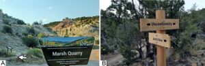
Figure 10. Improvements in the GPNNL includes signage and trails. A, signage at the parking lot and trail (arrow) near the Marsh Quarry (above sign in foreground). Note signage panel along the trail. B, trail signs.
Berta then began a much broader Resource Management Plan (RMP) for the Royal Gorge Resource Area (RGRA), which includes Garden Park and most of southeastern Colorado (Berta 1993). This plan identified the resources, including vegetation, livestock grazing, riparian areas, forests and woodlands, wildlife habitat, fishery habitat, minerals, recreation, historical and archaeological sites, and paleontological resources. Furthermore, the plan laid out the impact the various management plans would have on these resources. The recommended management plans were presented twice to the public for feedback (Berta 1994, 1995) before a final plan was accepted (Deike 1996). The accepted plan designated Garden Park as a paleontological Class 1 area in need of special management and that 2,728 acres (11 sq. km) including most of the historic dinosaur quarries were designated an Area of Critical Environmental Concern (Fig. 2). The ACEC designation prevents mining and drilling for oil, restrict livestock grazing, and restrict OHV to defined trails and roads.
One serious issue identified within the RMP was a proliferation of roads and trails throughout Garden Park because of off-highway vehicles (OHV) scarring the landscape. As soon as one person created a path by driving cross-country, others followed and, because of the arid environment, the vegetation did not grow back readily. An area-wide effort defined and designated authorized roads and trails (Fig. 10B) and closed off other routes to allow the vegetation to regrow. Defining roads also identified those that needed periodic maintenance due to erosion. An updated summary of the paleontological resource of eastern Colorado was prepared by Murphey et al. (2015) as part of the 20-year cycle revision of the field office-wide RMP. They identified the Morrison Formation, such as at Garden Park, as a Class 5 in the Potential Fossil Yield Classification of the BLM (Table 2), and also recommended that some of the adjacent private lands in Garden Park with exposures of the Morrison Formation should be acquired by the BLM.
The Community Pitches In
As the RMP in the early 1990s developed and altered through community input, the public became more aware of both the importance and the issues associated specifically with Garden Park. One of the first signs of changing attitude was a community organization to undertake a major cleanup of Garden Park in 1990, with many tonnes of trash and debris removed and damaged parking areas repaired (Fig. 11A, B). At about this time, the Garden Park Paleontological Society (GPPS) was formed. This nonprofit organization of amateur paleontologists had a focus on the history of Garden Park, care of the paleontological resources, and development of local paleontology expertise. Many of the GPPS members graduated from the Certification in Paleontology Program at the Denver Museum of Natural History (DMNH; now called the Denver Museum of Nature and Science). The program was museum-based paleontology, with various classes in field paleontology, fossil preparation, curation, research methods, and report writing. This approach enabled avocational paleontologists to provide assistance to professional paleontologists, while gaining important hands-on training.
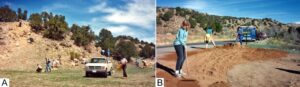
Figure 11. The community pitches in (circa 1990?). A, cleaning up trash, including broken glass; B, repair of rutted parking area. Photographs courtesy of the BLM RGFO.
Many people and organizations came together with the discovery of a Stegosaurus skeleton in 1992 (Fig. 12; Carpenter 1998). Its excavation and subsequent preparation were made possible by the coordinated efforts of the DMNH, BLM, GPPS, the community, the city of Cañon City, and the United States Army from nearby Fort Carson (Fig. 12; see online BLM story at https://www.handsontheland.org/garden-park/small-quarry.html). The City obtained grants and other funding to convert an abandoned fire station for use as a small museum, Dinosaur Depot, where preparation of the Stegosaurus skeleton could be done under the watchful eyes of visitors. When preparation was completed, the DMNH prepared a plastic cast of the skeleton in its natural articulation. With the closure of Dinosaur Depot in 2013, many of the specimens and the Stegosaurus cast were moved to the nearby Royal Gorge Regional Museum and History Center (RGRMHC) owned by Cañon City where it remains today. The RGFO BLM field office now works closely with the Regional Museum, which is a federal repository for archaeology and paleontology materials from public lands.
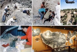
Figure 12. Community support surrounding the 1992 Stegosaurus discovery. A, volunteers helping the excavation; B, crew of Colorado Quarries undercutting the main body block, which is encased in plaster of Paris; C, U.S. Army Chinook helicopter lifting the main body block; D, Garden Park Paleontological Society Member Donna Engard working on removing rock from the skeleton; E, cast replica of the small Stegosaurus skeleton on display at the now defunct Dinosaur Depot in Cañon City.
Expansion of the National Natural Landmark
The original GPNNL established in 1973 was only 0.16 sq. km (40 acres) and did not include any of the major historic dinosaur quarries. In addition, only a small amount of the area had a high potential for new discoveries. Nevertheless, GPNNL was considered for inclusion as a Geology National Historic Landmark in a 1990 draft theme study of the history of American Science because of Garden Park's importance to the history of paleontology in the United States (Butowsky 1990). This theme study was conducted by the National Historic Landmarks Survey of the National Park Service in compliance with the requirements of the Historic Sites Act of 1935 (Butowsky 1990, 2005). Because the original NNL did not include any of the historic dinosaur quarries, the BLM proposed expanding the boundaries.
In 2012, Karen Decker of the Colorado Natural Heritage Program completed an evaluation report supporting expansion of the GPNNL from 40 acres to 3,200 acres (13 sq. km) so that it would include all the significant quarries and scientifically significant areas. The recommendations were analyzed and accepted in 2013. Three years later a permanent rock monument and plaque identifying the GPNNL was placed at the Cleveland Dinosaur Quarry (Fig. 13A, B).
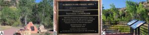
Figure 13. Garden Park Natural National Landmark monument, A, and detail of the plaque B. near the Cleveland Museum of Natural History Quarry; C, also present nearby are graphic panels discussing the discovery of the quarry.
With the upgrade in size of the GPNNL and the shift in local attitudes, several important changes were implemented by the Bureau of Land Management to better protect the paleontological and other resources. These changes included the introduction of the Geological Society of America’s (GSA) GeoCorps America program to the RGFO. Through this program college students and recent graduates gain work experience in the federal government during short-term internships. This program offers geoscience opportunities and is operated in partnership with the Bureau of Land Management and U.S. Forest Service.
Monitoring. Monitoring of the areas with high potential for fossil discoveries, including the historic dinosaur quarries, is now completed on an annual basis. All land use proposals now consider the impact on the fossil resources. Periodic BLM Ranger patrols of the area help discover sites where deliberate or inadvertent damage are occurring and are subsequently dealt with.
Mountain Biking and Hiking. The growth of mountain biking and hiking as recreational activities in the past decade resulted in many kilometers of trails constructed on the east side of the GPNNL (Fig. 10B). Today there is substantially more public use of the GPNNL, but with negligible environmental, paleontological, and historic site damage. Most of these recreationists have a “leave no trace” mentality and have shown a great appreciation of the natural resources within the area.
Interpretive Sites. An interpretive trail to the overlook of the Marsh-Felch Quarry was constructed in the late 1990s by volunteers and BLM interns, enabling visitors to view the quarry from a location where it was photographed in 1888 (Figs. 5A, 10A). A second site along the main access road allows for interpretation of the Cleveland Dinosaur Quarry (Fig. 13C). These two sites are regularly visited by the public and utilized in a wide range of educational programs.
Target Shooting: Indiscriminate target shooting has been greatly reduced in large part because a relatively small area on the west side of the GPNNL has been set up for target shooting. This has made a tremendous improvement in the overall area by increasing safety for other GPNNL users and eliminating broken glass from bottles used as targets.
Hands on the Land Website: To expand public outreach on the GPNNL, the local BLM field office entered into a partnership with “Hands on the Land,” a federally supported nonprofit organization that provides a national network of “place-based learning at America’s public lands and waterways”. The Hands on the Land website hosts historical and paleontological information about the various dinosaur sites in the GPNNL (https://www.handsontheland.org/garden-park/). Much of the work associated with the site was developed by GeoCorps interns.
The Future
We present several recommendations for the continued development of GPNNL. None of these recommendations is binding and none is ready to be formulated as an action plan. Chief among these is to have GPNNL designated as part of either a larger geoheritage area or a geopark that incorporates the Gold Belt Tour National Scenic Byway (Bailey and Hill 210). This 210 km (131 mile) scenic byway created in 1990 uses existing paved and gravel roads to connect areas of scenic beauty, outstanding geological areas, and historical mining towns in south-central Colorado (Byways Corridor Management Plan, undated). Besides GPNNL, the byway also includes the important paleontological sites of Florissant Fossil Beds National Monument and Indian Springs National Natural Landmark.
Also recommended is an expansion of the interpretive trails to incorporate more of the historic paleontological sites. This could include a loop trail directly to the Marsh-Felch Quarry and an extension trail to the Cope-Lucas Quarry areas. These trails would be enhanced with interpretive signage highlighting geology and plants, as well as signage at the quarries explaining the stories of their development. Such an expanded network of trails to the quarries is dependent on proper protection of the sites. Additional options for expansion of the recreational hiking and mountain biking trails on the west side of the GPNNL could connect Shaw’s Park to the west with Red Canyon Park to the north. Both the Marsh-Felch Quarry and the Cope-Lucas Nipple quarries were nominated for the National Historic Register in 1990, based on their importance to the early history of American science, but there has been no further action. It is recommended that the sites be brought forward for permanent listing on the register to memorialize their importance to the early history of American science. Finally, we recommend that the historic Kessler Stegosaurus site be incorporated into the NNL by working with the land owner. Ideally, the quarry and surrounding land should be obtained by the BLM through purchase or land trade. Regardless, once integrated, all of the historic paleontological sites would then be part of the GPNNL.
Conclusion
Garden Park located north of Cañon City, Colorado, played an important role in the history of dinosaur paleontology in the United States, and by extension early American science. It was here that the first articulated dinosaur skeletons and first complete dinosaur skulls were found beginning in 1877. Prior to 1987, Garden Park was used in manners that were at odds with the protection of the paleontological and historical resources. Despite designation of a small area as a Natural National Landmark in 1973, none of the dinosaur quarries were included or protected. Since the implementation of the first management plan by the Bureau of Land Management for Garden Park in 1988, a more serious attitude prevailed. The changes were incremental, as parts of the public lands in Garden Park were first declared a Research Natural Area in 1987, then much larger area designated as an Area of Critical Environmental Concern in 1996. These changes in BLM’s management direction paved the way for an expansion of the Garden Park National Natural Landmark in 2013. As part of these changes, private property that contained some of the historical dinosaur sites was purchased and is now protected. Further recommendations include incorporating the GPNNL into part of a larger geoheritage or geopark site that includes the Gold Belt Byway, expanding the network of trails and signage, and including the Kessler Stegosaurus site into the NNL.
Conflict of Interest
The authors declare that they have no competing interest.
Acknowledgments
Thanks to the many volunteers that helped us in Garden Park over the years, including clean-up of trash, building trails, excavating fossil bones, and gathering archival data on the early history. Thanks to James Kirkland and an anonymous reviewer for comments on an earlier draft.
Appendix 1
Fossil fauna of the Garden Park National Natural Landmark. Taxa considered valid today in bold, holotypes (specimen upon which the description and name of a new species is based) with asterisks (*).
# on Fig. 2 | Quarry | Vertebrate Taxa |
1 | Marsh-Felch | Allosaurus fragilis* |
|
| Amphicotylussp. |
|
| Brachiosaurussp. |
|
| Ceratodus guentheri |
|
| Ceratosaurus nasicornis* |
|
| Dinochelys whitei |
|
| Diplodocus longus* |
|
| Docodon sp. |
|
| Eutretauranosuchus sp. |
|
| Glyptops plicatulus |
|
| Haplocanthosaurus priscus* |
|
| Haplocanthosaurus utterbacki* |
|
| Kepolestes coloradensis* |
|
| Labrosaurus ferox* |
|
| Morosaurus agilis* |
|
| Nanosaurus rex* |
|
| Stegosaurus stenops* |
|
| Tanycolagreus topwilsoni |
2 | Cope Quarries | Amphicoelias altus * |
|
| Amphicoelias latus* |
|
| Amphicotylus lucasii * |
|
| Apatosaurussp. |
|
| Brachyrophus altarkansanus* |
|
| Camarasaurus leptodirus* |
|
| Camarasaurus supremus* |
|
| Caulodon diversidens* |
|
| Caulodon leptoganus* |
|
| Epanterias amplexus* |
|
| Glyptops plicatulus* |
|
| Hypsirophus seeleyanus* |
|
| Hypsirophus discurus* |
|
| Hypsirhophus trihedrodon* |
|
| Laelaps trihedrodon* |
|
| Maraapunisaurus fragillimus* |
|
| Morosaurus laticollis* |
|
| Symphyrophus musculosus* |
|
| Tichosteus lucasanus* |
|
| Tichosteus aequifacies* |
3 | DeWeese | Diplodocus longus |
4 | Cleveland Museum | Eutretauranosuchus delfsi* |
|
| Glyptops plicatus |
|
| Haplocanthosaurus delfsi* |
5 | Lindsey | Allosaurus fragilis |
|
| Camarasaurus grandis |
|
| Glyptops plicatulus |
|
| Opisthias rarus |
6 | Small Quarry | Amphicotylus sp. |
|
| Camarasaurus grandis |
|
| Ceratodus guentheri |
|
| Dinochelys whitei |
|
| Docodon apoxys* |
|
| Dryolestes sp. |
|
| Dryosaurus altus |
|
| Glyptops plicatulus |
|
| Kepodactylus grandis* |
|
| Mymoorapelta sp. |
|
| Stegosaurus stenops |
Other sites | Allosaurus sp. | |
|
| Amphicotylus sp. |
|
| Glyptops plicatulus |
|
| Hallopus victor* |
|
| Nanosaurus agilis* |
|
| Preprismatoolithus coloradensis |
|
| Stegosaurus sp. |
|
| Torvosaurus cf. T. tanneri |