Introduction
Rock art, an invaluable testimony left by ancient people, is particularly abundant in North Africa, including Morocco. In many cases, however, rock art is the only archaeological component remaining to testify to a “shelter’suse” (Gunn et al. 2018, p.3). In some literature, the landscape of rock art sites is fundamental to understand how communities related to a natural environment; and how they were inhabited and structured (Wilson & David 2002, see also Nami et al. 2014 for a social interpretation of changes in regional engravings rocks use over time). In addition to its artistic interest, from this site, we can deduce information about the climate, fauna, culture and identity of the people who lived there, from Neolithic to historical times. Rock art may not have been the first artistic manifestation of humans but it is the oldest artistic form which has survived. Through engraved or painted designs, sometimes made with precision and apparent realism, or sometimes highly stylised, prehistoric people expressedtheir ideas. They thus archived and sent us marked moments of their daily life, civilization and culture. These archaeological materials allow us to approach and understand these civilizations and some features still mark our culture today. The material needs to be kept together, on the site, so we can read the elements like pages in a book to reconstruct as long as we can study the civilization, or civilizations producing the rock art.
This short paper is dedicated to provide some information about Foum Chenna and how it can be used for educating the public about rock art, provide an environment for scholarly research, and promote the preservation and conservation of rock art, and its use for sustainable development of the area for the benefit of the current inhabitants. Our study is based on the direct contact with the rock art in question and meticulous field research, we hope that this concrete basis will enable us to achieve these objectives.
Literature review
Archaeology and rock art of Drâa Valley
The diverse archeology of Morocco continues to provide an important natural laboratory for the study of rock art. In Morocco, the rock art sites are distributed between the oases of Figuig in the north-east and the Moroccan-Mauritanian borders in the extreme south. They are located along the Drâa valley, Saquia el Hamra and Oued Ed Dahab but also in the highlands of the High Atlas (Nami et al. 2014). It is often the sandstone ridges whose rocky surfaces contain rock art representations having varying qualities. Today, the existence of rock engravings seems to be systematically linked to particular natural factors: the proximity of a hydrographic network, the existence of pastures and the availability of an adequate rock support. The Drâa, southern Morocco, is an ideal venue for archeological and geological investigations. Sporadic investigations into the prehistory of the Drâa Valley began during the French colonial period of the previous century but sustained research only began in the last decade. Since the end of the 19th century, when the first discoveries of rock art in this region were made, more than 150 sites of rock engravings have been recorded (El Graoui 2005). The cultural traits of the human populations that occupied these territories are very specific. The spatial distribution of sites appears to be of paramount importance to the hydrographic networks in the human settlements and in the determination of the territory of the hunter-gatherers and later of the pastoral and nomadic populations. The study of the engraved themes shows a multitude of subjects. The types of animals engraved allow us to assessthe evolution of the ecology over time and the impact of progressive climate change on humans living there. They also show the ways in which a mode of subsistence based essentially on hunting resources is transformed into a pastoral way of life, as well as the evolution towards material cultures specific to the appearance and control of metal artefacts. Other symbolic themes were also engraved and are different in composition from one period to another. These are essentially abstract signs or even thematic associations whose real meanings are difficult to hypothesise (Nami et al. 2014).
The Drâa Valley [Drâa: Morocco’s longest river (1,100 kilometers)] was formed by a narrow ribbon of water, begins from the High Atlas mountains and its mouth reaches the Atlantic Ocean somewhat north of Tan-Tan. It is a specific cultural region for archaeological research (Zainabi 2004) essentially because of the geological context of the area. Specified With one notable exception, the valley includes the Fezouata Formation, Burgess shale-type deposits dating to the Lower Ordovician (Van Roy et al. 2015). The average annual rainfall of the area is 61mm and the average temperature is 40 .
In the Drâa region, climate changes were perfectly recorded by the people themselves through a parietal iconography which is considredy. The rock art data can then be studied, not only as archaeological documents resulting from ancestral material cultures, but also as alternative sources in the outline of a “history” of the landscapes of human societies (Rognon 1987).
At the end of the Paleolithic and at the beginning of the Neolithic phases, the Drâa region sheltered populations of hunters who lived in the natural conditions favorable to human habitation. The rock art images reflect the existence of a varied bestiary made up essentially of a so-called tropical fauna withelephants, rhinoceros, giraffes, and antelopes which constituted the game preferred by the hunters. These kinds of animals could survive only in particular ecological conditions that would be comparable to the current African savannahs. The climate would have been more temperate and wetter than today. The plant cover would also have been much richer and much more luxuriant that could support this entire animal world, almost all herbivore (Rognon 1976).
In later periods, after the introduction of domesticated animals, the rock walls included large number of friezes showing herds of cattle, sometimes in association with anthropic representations. Cattle, as we know, require an ecological environment very different from that currently prevailing in the Drâa Valley and the southern borders of the Anti-Atlas. Towards the last centuries before the Christian era, the rock engravings only included domestic animals that could survive heat and drought such as goats and dromedaries, often associated with a panoply of signs and symbols that are the first characters of Libyan Writing. The variety and diversity of the sites, themes and the techniques used to engrave give this zone an important pedagogical quality, with sites that are as original as they are unusual (El Graoui 2005).
To a great degree, the rock paintings (colors are applied to different places, normally red, black or white, defining diverse motifs), engravings, and burial mounds have been placed in diverse points of the Middle Drâa Valley (Ait ouaâzik, Assif Ouigane, Foum Chenna, Chaâba Lbâida, Tibasksoutisne, Jorf Elkhil, for rupestrian paintings and etchings, and the giant necropolis of Foum Larjam for burial mounds), although a greater concentration appears to be found in the Foum Chenna site. In the Middle Drâa Valley, there existed a large number of big cemeteries containing burial mounds located in areas called “necropolis”. These inscriptions are related to the Libyan writing, ancestor of the Tifinaght currently in use to transcribe the Tamazight language. This is attested particularly at the site of Foum Chenna which has the largest number of engravings and rock inscriptions in Morocco. The famous inscription of the Azib n’Ikkis in the High Atlas, now destroyed, is often described as the oldest by associating it with an archaeological context attributed to the Middle Bronze Age.
The region is a part of the arid bioclimatic zone (Le Houérou 1995), alongits northern and southern fringes. This position clearly influences the distribution of faunal processions in the area of overlap between two main areas: the Mediterranean domain and the Saharan area. The territory is demarcated, with long rosaries of oases rich in palm and oasis crops with large areas populated by some grasses and acacia particularly adapted to the arid conditions of the desert. The acacia, which is the main forest species of the region, is sometimes concentrated in depressions storing nocturnal roses and in some cases, dense and covered islets, and true dromedary herds.
The oasis economy is a varied economy based on fragile agro-pastoral practices: phoenicultural production, annual crops of cereals (durum wheat, barley, maize), and vegetables grown under shade in the understory of date palms, fruit trees (olives, almonds, and figs). Agriculture is the main economic activity of this region. It is a subsistence agriculture based on small irrigated and cultivated properties of traditional material. The Henna tree (Lawsoniainermis) is highly responsive because of its relatively perennial character, and is used as fodder for sedentary cattle, sheep and capins (Garcin 2016). Faced with harsh living conditions, the activities of the inhabitants tend to diversify, that is to say, to be no longer just agropastoral or mining, but also extending to sustainable tourism.
Foum Chenna: characteristics and chronology
Foum Chenna open-air rock art site is located approximately 7 kilometers west of Tinzouline at a height of approximately 960 m (30°29,124’N; 06°10,114 W) in an area where the contrast between the soft green of the palm trees and the hard rock gives the place a rare beauty (Figs.1 & 2). The site belongs to the Libyco-Berber period. The people of the town of Tinzouline are well aware of the rock art heritage preserved in the surroundings of their home town. The site, discovered by Reine in 1942, was first reported in 1952 by Glory, Allain and Reine (Glory et al. 1952), who counted around 3,000 engravings, scattered over a length of one kilometer, this distribution is the result of a geological formation with rock suitable for engravings. The most usual common rock support for the engravings is sandstone with flat, horizontal, vertical or sloping surfaces. Other rocks, such as limestone, have also been used but the engraved works on them are less well preserved (El Graoui 2005). The numerous studies of Foum Chenna rock art to date have largely concentrated on properties of the more readily identifiable styles and their chronologies, or identifying depicted artefacts (e.g., see a central and fundamental issue in rock art about the Foum Chenna: Bravin 2014; Pichler 2008; El Graoui 2005; Zainabi 2004; Searight 2001; Simoneau 1968, 1977; Reine 1969; Glory 1953; Glory et al. 1952).
The field of rock art suffers again and again from a lack of reliable absolute chronological dating. While paintings made with organic materials could be directly dated by radiocarbon, the engravings have not yet found an ad hoc method for their physical dating despite attempts already made in this area. The Foum Chenna engravings rocks became known to the public in the nineteenth century and immediately attracted much scientific attention.
According to the El Graoui (2005), more than 80 schematic engravings have been made, using the pecked technique, a characteristic of this period. They represent domestic animals (dromedary), wild animals (ostrich, lion/leopard), horsemen armed with shields and lances, fighting scenes and ostrich-hunting scenes. In addition, there are Libyco-Berber inscriptions, which in fact are so far known among all the Moroccan rock art sites. These engravings, the easiest to distinguish, are superimposed on other older ones, with black-patinated lines blending into that of the rock. In particular, an ostrich and a bovid can be distinguished; they indicate two distinct periods of site frequentation.
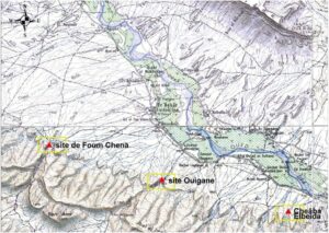
Figure 1.Simplified geological map of the study area (from the geological map of Morocco, scale 1/1000 000) (modified from Hollard & Choubert 1985).
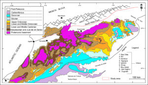
Figure 2. Location of the rock engravings sites of Tinzouline (Topographic map of El Gloa, scale 1/100,000) from Beraaouz (2011).
From the data known at present, the spectacular Foum Chenna site represents the largest concentration of rock art in the Middle Drâa Valley and without a doubt deserves to be called spectacular with the most important prehistoric rock art in southern Morocco (Table 1). In addition, alphabetical inscriptions classified as Lybico-Berber are also frequent in this site (Glory 1953). The engravings of Foum Chenna are on Cambrian sandstones of Jebel Tabanite, Anti-Atlas, Morocco (Salih & Heckendorf 2002) with figures and letters pecked out on the vertical walls of the cliffs overlooking the left bank of Oued Foum Chenna. Only forty engravings have been recorded on the right bank. Today the area is arid with only camels and goats as domesticated livestock but the animals depicted indicate a former wetter and milder climatic period, providing grass and water. There are also many inscriptions, often found near these primitive drawings. They are thought to be words written in ancient Lybico Berber script (specifically the tifinaght alphabet) (Fig.3).
Table 1. Biography of the Foum Chenna in Tinzouline, Southern Morocco (Searight 2001).
Contents
| Small, pecked antelopes (a few), mostly armed Libyco-Berber horsemen and foot soldiers, battle and hunting scenes, camels, felines, dogs, ostriches, Libyco-Berber inscriptions |
Dating | Black patina the oldest (antelopes) = "metal age"; 2nd patina (horsemen and foot soldiers) = younger; 3rd patina (armed horsemen and foot soldiers, Libyco-Berber inscriptions) = pre-camel; 4th patina, lighter (camels, same horsemen, battle and hunting scenes) (Reine 1969). |
History | The site had been known since 1942 and was first reported at the 1952 Panafrican Prehistoric Congress under the name of “Oumchena”. The site was later briefly mentioned by Simoneau and the name corrected to “Foumchena”. It figures as “Foum Chenna” in the Catalogue des Gravures Rupestres du Sud Marocain under the reference 150.044 A (Simoneau 1977). |
Figure 3. View of site of Foum Chenna. (a) The road to the site; (b, e, f) The new interpretation Centre built by the Moroccan Ministry of Culture and some Executive Board of the association; (c) This well, dug in 2013, with a depth of 10 meters, allows tribes, nomadic or sedentary, to maintain their traditional way of life. Equipped to draw drinking water, it also includes a trough for animals (camels, goats, and sheep) in the region or in transhumance; (g, h) threat of destruction by human activities (disfigurement and rubbish); (i, j) Selection of engravings from Foum Chenna (Horseman, leopard/lion, Libyco-Berber letters, animals, ostrich, etc) and; (k, l) Natural landscape in the Foum Chenna (date palms) (all photos by M. Abioui, 2015).
The mounted horse and the ancient Libyan alphabet are important elements for the establishment of a chronology of Moroccan rock art (Searight 2001; Heckendorf 2008 a, b), discovering and applying new techniques to understand motif styles and their chronology is necessary for the Foum Chenna site (For more information about the methodology for dating the rock art, see Bednarik 2002). Both pecked and polished techniques were used. Patination varies from complete (the same color as the supporting rock) through medium to fresh. In general, the engravings are small, 30-50 cm. No image larger than 1 m was noted (Bravin 2014). Not far from Foum Chenna site, there are two other sites in the area, in the same style and the same period, namely Assif Ouigane and Jorf Al Khalil (Fig. 2). The lattercontains about a hundred engravings, mainly of horsemen, horseshoes and jewelery, including fibula and little circles which could be interpreted as bracelets (El Graoui 2005).The last advances in the studies of Foum Chenna rock art (e.g., Abioui et al. 2018; Beraaouz et al. 2017; Bouzid et al. 2012; Beraaouz 2011) provide additional and better data, which are also taken into consideration in this study. The Foum Chenna locality is an excellent example of a rock art site which has been very effectively interpreted for public viewing, geotourism and geoeducation.
Method
This publication reports the result of fieldwork in Foum Chenna, southern Morocco that was conducted in April 2015 and discussed the previous studies above, as part of research work and valorization of the natural heritage in the southern regions of Morocco led by the Geo-environment and Geoheritage Group, Department of Geology, Faculty of Sciences of Agadir (FSA), Ibn Zohr University. The results of this endeavour are summarized here, forming a continuation of the 2018 report (Abioui et al. 2018). Most of them have not been reported before. However, the most direct precedent for the current management model of archaeological data in Zagora Region is the archaeological site inventory of the Moroccan Ministry of Culture (MMC) from 2005 (El Graoui 2005).
The experience of the groundwork accumulated during these years has happily led us to a new concept of valorization of natural and cultural wealth through geotourism, and towards the establishment of a real reference in this field by continuously refining to the circumstances of each geosite. The final objective was the realization of a general atlas of all the heritage aspects of the southern regions of Morocco (movable and immovable heritage, intangible values and know-how, archaeological sites, geological sites, etc.). The result obtained far exceeds our expectations and we are now in the presence of valuable and a scientific documents on the nature. The experience of Foum Chenna has been valuable as a pioneering action and it would highly be able to generalize to other rock engraving sites in Morocco.
The geographical location of the Drâa region has given it the character of a cultural refuge zone, because, it has really provided a route for the passage of various cultural currents during the different historical periods. Rurality is still dominant today. Several heritage components are therefore still preserved in the living state. As we have previously said, our new working approach has also been based on participatory action in the sense that, on the ground, all the actors involved have been associated: local authority, municipality, local population, civil society, etc.
High-resolution outcrop photographs are taken to aid us in the description of the rock engravings. As shown in other rock art settings, the methodology in this paper follows the recent research for ageotourism approach (e.g., Dowling 2011; Allan 2012; Hose 2016; Olson & Dowling 2018; Macadam 2018) and represents a powerful tool to shed light on rock art tourism. During the last few decades there has been growing concern about how to integrate rock art sites and sustainable tourism, e.g. Deacon 2006, Duval & Smith 2013, Darvill & Fernandes 2014, Duval & Smith 2014, Laue et al. 2018, in South Africa. The writing of this article was inspired by the desire to contribute to the general reflection ongeotourism and sustainable development of the region. Tourism is often criticised for its negative impact on rock art sites (Duval & Smith 2014). Thus, focusing on its geotourism potential through its identification and valorisation, geosites[1] can be the best hope and a useful tool contributing to sustainable economic development of the regions (e.g., Wojtowicz & Wojtowicz 2016 and references therein).
“Geotourism” does not exist in classical dictionaries. But the word “geo” comes from the Greek meaning “Earth”. It, therefore, refers to tourism of the earth. It is a form of tourism that supports and highlights the geographical character of a place, its environment, its culture, its aestheticism, its heritage and the well-being of its inhabitants. It also adopts the precept of ecotourism according to which tourism promotes the conservation of nature. Therefore, geotourism encompasses the principles of sustainable development and the protection of the local characteristics of the destination as well as the benefits it can bring to visitors and residents alike. Geotourism engineering is applied to the Foum Chenna site that was selected according to scientific criteria, landscape classification such as scarcity, representativeness, the tutorial example, the aesthetic, history, culture, and ease of access for direct or indirect exploitation (e.g., Reynard et al. 2015; Zwoliński et al. 2018). The results of this proposed approach represent awareness and protection recommendations for this universal archaeological asset.
As previously mentioned, in Morocco, such as other developing countries, the new tourism product of “geotourism”, here suggested, keeps the cost for the presentation of products in the first place to a customer, curious to discover nature in its ecological aspects. The promotion of these products can be done either by personal initiative or in collaboration with the tourism establishments to support, enrich and diversify the tourism offering in the region. The aim of this contribution is to discuss the relationships between rock art and the production of sustainable tourism networks at Foum Chenna. As a result rock art tourism in Foum Chenna engraving site is very meager. According to Allan (2015, p.25), “Geotourism (tourism with a geological purpose) has great potential to sustain and conserve our geological heritage”. However, geotourism and geoeducation require sound foundations to communicate essential information to the geo-tourist and the importance of “getting the right message across” to all visitors, including international tourists, should not be underestimated (Erfurt-Cooper 2011). The overwhelming evidence on rock art on top of its environmental potentials makes it suitable for geo-education activities. Whereas, the living cultures of the present day inhabitants from the past make it suitable for geo-tourism and heritage activities.
Results
The policy is to keep rock art in situ– except when it is endangered by road works or flooding under a reservoir. In such cases the petroglyphs are removed and placed in a museum, such as the National Center for Rock Art Heritage, in Agadir. But Foum Chenna is already an informal open-air museum and this is in the process of being formalised by a building, funded by UNESCO’s World Heritage Fund, at the entrance to the site, which will in future house a reception point with a visitor center and a permanent exhibition.
Rock engravings are an extremely valuable heritage under threat of destruction, not only by nature but also mostly from human activities. The site at Foum Chenna is open to both elements and to vandalism and theft. Since 1994, Morocco has had a prohibition on export of rock art but more recently the Ministry of Culture has put in place measures to regulate previously uncontrolled visits[2] to rock art sites, and adopt standards of good practice for managing the impact of both foreign visitors and locals (Simoneau 1977; El Graoui 2005). Visitor books provide an outlet for visitors to direct their desire to leave their mark on the rocks, butmay not be necessary at Foum Chenna because it is safeguarded by the MMC staff. Aside from the content supervision of the site by staff of MMC, rock engravings are also protected by the access road to the site. As a public site Foum Chenna is well conserved. There are substantial efforts to monitor the site’s hydrology, interstitial water being the one cause of site deterioration.
In addition to these state-sponsored initiatives the Association of Rock Art Heritage of Southern Morocco was set up in 2012 and has so far organised four guided trips to raise public awareness of the petroglyphs in Foum Chenna, as well as developing a website. The first author (M.A.) was funded to undertake training in 2014 on “Tourism & Heritage: Inventory and valuation of territories” at the European Museum of Civilisation & the Mediterranean in Marseille, France. He has also taken part in an information day at the National Library of Morocco on “Rock Art: an ancestral cultural heritage between the challenges of conservation and development issues”. The problems of conservation and promotion of rock art heritage, specifically in Foum Chenna, have also been highlighted in the national paper, L’Economiste (issue 5167, 13 December 2017). The site has also been submitted, as ’Rupestral Inscriptions of Foum Chenna’, in 2011 for UNESCO’s Memory of the World Register has not yet been inscribed. To date,the Geopark M’Goun (Central High-Atlas, Morocco), only Geopark in Africa and Arab, is given the label by Global Network of National Geoparks (GGN) developed under the auspices of UNESCO, during the 6th World Conference on Geoparks in Canada in September 22, 2014 (Errami et al. 2015; Bouzekraoui et al. 2018). According to African Geoparks Network (AGN), a geopark is an area where the geoheritage and all heritage components (archaeological, ecological, historical, tangible and intangible cultural elements) should be used as a tool to (Errami et al. 2015): (i) improve the infrastructure of rural areas through the development of geotourism by building roads, creating and improving accommodation, supplying remote areas with electricity and drinking water, creating adequate spaces to sell local products, including the development of museums and cultural/information centres; (ii) enhance human development; and (iii) promote sustainable peace in all regions of Africa and the Middle East.
Discussions
The work carried out so far forms a low-key but solid base. The engravings at Foum Chenna are the most important prehistoric engravings in southern Morocco: a priceless, irreplaceable, cultural and archaeological treasure and promoting responsible tourism could generate jobs and income and could also help increase people’s pride in their heritage. This would, in fact, be the most effective means of conserving the heritage. Heritage regulations to protect Foum Chenna’s cultural and natural heritage can guide development projects in the region to ensure that any possibility of damage is minimised. Any development of the site without an environmental conservation plan, based on a thorough environmental impact study, could lead to irreversible degradation.
Initially, local people need to have their awareness raised, by school children being educated about their heritage so they have a better understanding of Foum Chenna’s ancient past, and can pass this information on to their parents as well. We suffer from the absence of marketing and emphasis on making sustainable tourism strategies by incorporating local people and valorising heritage sites; creating better visitor experiences and raising the profile of rock art (Laue et al. 2018). Promotion of the site needs to follow best practice in communication – ideally adopting the standards set in the National Parks of the USA, based on Freeman Tilden’s work (Tilden 1957). Development of guided walks and tours will help generate income for village organizations and make the preservation of such heritage sites economically viable. To preserve this cultural site, it is necessary to introduce marked self-guided trails and to close certain engraved areas. This site enhancement action will include it in the socio-economic and cultural fabric of the region. People are pushed towards artisanal mining, fossil collectors and dealers of Zagora[3], however, high commodity prices also attract some. Therefore, some of these people do it temporarily when their other sources of income such as agriculture and tourism, are not enough.
The wider region also has a rich geological heritage-particularly famous for the Fezouata Biota, of Ordovician Age (Van Roy et al. 2015), but also for spectacular landscapes (well-used as backdrops by the film industry). The area is also well-known for its more modern cultural heritage, covering the last few hundred years. Developing all these strands together could make the area a candidate for UNESCO Global Geopark nomination. A geopark in this area would be a place of geo-education and research relating to rock art and the geology. The establishment of a geopark (UNESCO 2016) follows three objectives: to preserve and protect a geological/archaeological or cultural site, to organize activities for educational purposes, and finally to participate in the growth of local and regional economies by highlighting geotourism. Visits guided by scholars, students and amateurs will help to promote this part of the Anti-Atlas and its geological heritage. Different geotrailsand trails for bicycles could be developed. In all these works, geotourism in these areas could help to increase the living standard of the local communities through the creation of socio-economical activities: All options for tourism development must serve to improve the quality of life of the local population and contribute to the socio-cultural enrichment of each destination. This site has survived the ages and it is a place of stability, a place where we help to reconnect with ourselves, with the very natural environment of exceptional authenticity.
Issue of Concern
In recent times, some people have painted and drawn over the top of some engravings to the point that the original etching is completely invisible. Such vandalism is utterly reprehensible and spoils some of the most extraordinary manifestations of the culture of southern Morocco, which is of huge scientific importance. Trade and the illegal export of archaeological and ethnographic objects of southern Morocco have also taken an appalling toll on the heritage. It is time to seriously address the issue to propose concrete and urgent solutions. This is the legacy of our ancestors, this legacy is being lost gradually, and if we do not act in time, it will be sentenced to total erasure. Unfortunately, the cultural state of this heritage leaves something to be desired, the increasing urbanization of the territory is causing profound spatial and socio-economic transformation. The archaeological heritage is particularly threatened and further risks of deterioration and loss can be predicted. While much of this heritage has disappeared or suffered irreparable damage, another part remains unknown. This matter is compounded by the increasingly harmful effects of vandalism, looting and illicit trafficking in cultural property, from which the whole of southern Morocco continues to suffer exorbitantly.
Conclusions
In a world where markets reign supreme, we forget that the real wealth of a nation is measured by the level of knowledge of its people, and knowledge that is kept alive through memory. Rock art is a common heritage for the world and everyone must be concerned for its preservation: the competent authorities, local inhabitants and tourists. The rock art and the Foum Chenna engraving site in particular are called to play a fundamental role in the region of Zagora. The purpose of this study is to convert the natural heritage of this site to an opportunity for geotourismdevelopment through the potential nomination for a UNESCO Global Geopark (Farsani et al. 2014), and a protected national patrimony.
The Foum Chenna site is still not famous for its rock engravings, but we propose to plan its enduring regional development and public opening via several actions, as follows:
- Completely integratingthe site into the tourist circuit. This might ensure a wide diffusion and encouraging the setting up of an information centre. Rock art is an increasing tourist attraction all over the world. Geotourism is gaining popularityand contributes to local economies, particularly in rock art protected areas. On the other hand, the site has the potential to contribute to youth development and controlling rural exodus to neighboring cities.
- Educational facilities can be made available (geotrails, guide books, booklets or brochures, monographs, popular publications, exhibition catalogs, etc.).
- Making the population sensitive to the wealth of this cultural heritage objective and to make it an active partner for site management also. This is necessary knowing that the preservation and protection of the patrimony are both combined with physical and cultural anthropological behavior.
- Equipping the site with reception infrastructure, taking the preservation of the natural environment into account.
- Developing popular communication for the various socio-economic components: scientific, cultural, educational, and institutional sections.
- Integrating the local population in organized activities in the region as tourist guides or hosts for accommodation that could create income for them,and
- Finally, conserving this archaeological geosite that includes the scientific identification, documentation, and monitoring of these national treasures.
As reviewed in this paper, the value of the rock artand archaeological heritage can be increased by the introduction of geoconservation or geodiversity conservation (Burek & Prosser 2008) and protection. These examples highlight the need for careful management of the richness and diversity of the archeological heritage, but commercial exploitation and vandalism could permanently damage the inestimable scientific and patrimonial value. The creation of a geopark allows sustainable geotourism development that must be introduced by scientists according to an agreement and synergy between various regional tourism partners (Xun & Ting 2003).
In a rural area where heritage tourism is the main economic activity, politicians and development professionals are obviously very sensitive to actions on the site of Foum Chenna. Any alteration to an archeological site (crack filling, reattachment, massif consolidation, and the impregnation of rock surfaces), even if it is a minuscule alteration, will destroy part of our memory; therefore, the preservation of sites and their archeological contents is a task where everyone should be involved. This will be vital for the conservation of our history, so it can be transmitted to future generations. Scientists and archeologists are invited to supervise this strategyas their contributions are essential to ensure enduring sustainable management of the site. A regional effort must be deployed to promote this site. The promotion concerns actions and strategies aiming to make a site known and appreciated as a tourist destination. The rich heritage of this geosite represents an undeniable asset for the region in terms of attractiveness in the tourism market if it is exploited in a sustainable development, and can provide a partial answer to the new expectations of the tourists.
Research bodies can have a role to play here. In this short paper, we recommend a 3D scan of therock engravings in order to accurately document thematerial in danger. Photographs alone are insufficient to protect the rock art heritage of this famous site. Like in other developing countries, itis necessary to legally protect the material that remains in situ (i.e., in the form of a protected area, geopark reserve), and in addition to safeguard as much informationas we can.It is therefore of great importance to establish geotourism maps on which the location of the main fossiliferous, mineralogical and archaeological sites must appear. The sites have been observed to represent characteristics of different types of rocks and help to understand the geological evolution of the region and also the phenomena that gave birth to the landscapes. Overall, the results of this study are considered to also be applicable to other engravings sites in Morocco. While this study has opened more questions than it has answered, it has reinforced the value of small-scale archaeological landscape studies in interpreting changes in rock art, place use over time and geotourism. In this sense, Foum Chenna rock art can be used as a sustainable focus for cultural tourism. Rural tourism and agrotourism also represent an important opportunity to promote the Foum Chenna site at an international level as has happened in other countries (e.g., Cărătuș Stanciu 2017).
Conflict of Interest
The authors declare that they have no competing interest
Acknowledgments
The authors would like to express sincere thanks to Prof. Angus M. Robinson from Edith Cowan University (Australia) and an anonymous reviewer for critical but constructive comments for the improvement of this manuscript.We would also extend our thanks to Prof. John Macadam from University of Exeter (United Kingdom) for his suggestions on writing this paper and Ms. Mahshid Pezeshki, Executive editor, for careful editing. This project benefited from field assistance by E. Boulajraf, H. Lafraoui, B. Habibi, and A. El Kadiri (Association of Rock Art Heritage of Southern Morocco), discussion on rock art tourism with Prof. Janette Deacon from the Rock Art Research Institute (University of the Witwatersrand, South Africa) and who assisted with the English. Dr. Monica Axini (“Monachus” Group of Scientific Research and Ecological Education, Romania) is thanked for identifying some collected plants from the study area. The first author (M.A) wishes to extend his warm thanks to Mr. Ahmed Oumouss, Director of the National Center of Rupestral Heritage (Morocco) for facilitating access to relevant documentation in the Center’s library. M.A wishes also to express his gratitude to Prof. Abdelkhalek Lemjidi (INSAP, Morocco) and Prof. Abdelhadi Ewague (Chouaïb Doukkali University, Morocco) for their ongoing support with the rock art fieldwork at the numerous sites in Morocco, on which some of the approaches described in this paper are based. This paper is dedicated to the late Professor Driss Fadli (Mohamed V University, Morocco) who passed away on Monday, 25th of August, 2018. Prof. Driss Fadli’s activities were focused over his last years on how to highlight the geological, cultural and touristic assets of Jbel Bani Geopark (Morocco). We thus cautions the reader that any considerations regarding rock art and geotourism in this paper should be taken as our interpretative assessment.
[1] Geosites area unit locations significantly suited to reinforce information concerning the planet, its earth science history, and the way it changes through the action of endogenous and surface processes (Reynard 2004).
[2] Site conservation and geotourism: The public, young and old, visitor, picnicker or trekker, guide or organiser, is thus obliged to respect every engraving, small or big, imperfect or admirable, situated in zones under surveillance or not. During a visit to the Foum Chenna site, one must not: [a] Use the engraved zone as picnic place, [b] trample on the engraved slabs, [c] Take away the small engraved slabs to use them as decorative objects, [d] Damage an engraved slab by breaking it or by adding scribbling, [e] Use the big slabs as building material, [f] Carry a slab away under the classic pretexts that the engraved slab will thus be saved and protected from looting. The law 22-80, that relatesto the conservation of Monuments and Sites, Inscriptions, Objects of Arts and Antiquity-Dahir n°1.80.341 of 17 Safar 1401 (25 December 1980) clearly establishes that sites such as the rock art sites, as well as the associated portable art, cannot be moved, degraded, taken away or kept at home, or exported. Obviously, they cannot be the object of a commercial exchange. Every discovery must be declared to the competent institutions and remains the property of the Moroccan state. The rock engravings are legally recognised as a cultural heritage of humanity by UNESCO (Organisation of United Nations for Education, Science and Culture), ICOM (International Council of Museums), ICCROM (International Centre for the Conservation and Restoration of Cultural Property), and ICOMOS (International Council of Museums and Sites).
[3] Whose hard work and enterprising collection methods have resulted in acquiring material previously unknown to the scientific community (i.e., new discoveries of trilobites described in the work of Van Roy et al. 2015).
References
du Maroc, Rabat.