Introduction
This paper examines five new cyclists’ geotrails, developed between 2018 and 2021, spread across three counties (Bedfordshire, Buckinghamshire and Hertfordshire) north of London in the United Kingdom (UK) (Fig. 1). All are based upon Geologists’ Association (GA) excursions undertaken mainly between 1890 and 1920; their geological, historical, socio-economic and technological backgrounds are explored in terms of interpretive content. Almost from its inception in 1858, the GA organized a members’ program of excursions, the “...chief end and aim of its existence...its most useful form of activity...and its most important educational function.” (Watts 1909, p. 130). It documented and published on them in the Monthly Circular of the Geologists’ Association (MCGA) excursion notices and in the Proceedings of the Geologists’ Association (PGA) excursion reports. These are invaluable compendiums, despite landscape and infrastructure changes over much time, and they often provide enough detail to recognize places and probable routes of excursions.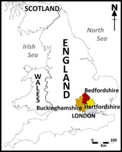
Figure 1. Location map – the three counties in which the modern geotrails are located are shown in relation to London and Great Britain.
Unusually for the period, the GA admitted men and women, professional and amateur geologists, to its ranks on equal terms; further, men and women freely mixed, without chaperones who were often required at the time, at its events and notably so on field excursions. This was in marked contrast to the venerable Geological Society of London, founded in 1807, which only admitted by election as fellows gentlemen of some social standing and geological expertise. At least a few of its influential fellows, such as Sir Roderick Impey Murchison (1792–1871), reportedly (Burek & Higgs 2007, p. 3) disparaged women’s intellectual and geological abilities. It only admitted leading women geologists as fellows from 1919. Further, whilst geological observations and papers by women could be read before the Society and published from the 1820s, it was not until 1904 that it permitted a woman to be physically present when her own paper was read (but by someone else!) before the Society. It was also not interested in admitting amateur, or hobby, geologists. The Geological Society did not develop a field excursion program, only lectures and presentation of research papers. Its publications, like those of the then Geological Survey of England and Wales (now the British Geological Survey), were often mentioned in the references of the MCGA excursion notices and some of the PGA excursion reports; both the Geological Society and Geological Survey sometimes permitted illustrations from their publications to be used in the excursion notices in the MCGA. Some influential geologists were both fellows of the Geological Society and GA members. For example, HW Monckton (Anon 1931) was at one time Treasurer and several times a Vice-President of the Geological Society as well as at various times the GA’s President, Secretary for Excursions, and Editor of the PGA; he advocated and was much involved in the GA’s cycling excursions, including its first such ‘Winchfield & Wokingham’ excursion in 1899 (Monckton 1899), followed by those to ‘Silchester’ in 1900 (Blake 1900), the ‘Aldershot District’ in 1903 (Monckton 1903) and the ‘Farnham gravel pits’ in 1904 (Monckton 1904). Meanwhile, outside London, contemporary local and regional geological and naturalist societies (Allen 1978) also organized programs of field excursions. They admitted both men and women to either equal or restricted membership (Burek & Hose 2016).
Between 1890 and 1920 the London-based GA was perfectly located to employ the railway network, then at its greatest extent, to get its members to excursion areas; it was noted at the time, “As railway...facilities improved the Officers of the Association have been quick to take advantage of them...and nowadays quite a long distance can be traversed to see important sections on a Saturday afternoon or on a public holiday” (Watts 1909, p.131). Railways were sometimes a major part of an excursion, such as the ‘Knebworth to Hertford’ in May 1914 (Hill 1914; Larwood 2016). The bulk of its excursions were pedestrian, although horse-drawn vehicles sometimes met excursionists at railways stations or along the route, until about 1920. For a very brief period, identified as 1899–1910 (Hose 2018a), the GA trialed excursions specifically for (or ‘dedicated to’) and accepted (or were ‘incidental’ for) cyclists. Hose (2018a) initially overlooked the May 1905 ‘Bedford’ excursion (Woodward 1905) because he had examined a part-guillotined, bound MCGA volume, so that eight dedicated and eleven incidental excursions (Table 1) can now be recognized. The majority of these cycling excursions took place in Edwardian times; this period can be explored usefully because it helps to explain the genesis of those excursions and can underpin associated interpretive provision for a wider modern audience than just geologists.
Table 1. Geologists’ Associations Excursions with some Cycling Element
Excursion Destination(s) | Date | Notes |
01. Winchfield to Wokingham | 8th April 1899 | Dedicated Cycling Excursion |
02.Bushey & Harrow Weald | 27th May 1899 | Dedicated Cycling Excursion:- PGA report notes “...cycling excursion…” |
03. Chilterns Hills | 8th July 1899 | Dedicated Cycling Excursion |
04. Wimbledon & Kingston |
28th April 1900 | April 1900 MCGA notice makes no mention of it being other than a pedestrian excursion; PGA report notes “...joined by several cyclists, who throughout the day followed the leadership of Mr. Stebbing.” |
05. Purley (Caterham, Godstone & Tilburstow) |
16th June 1900
| Dedicated Cycling Excursion:- June 1900 MCGA notice advises “Cycling detachment meet Mr. W.P.D. Stebbing (Cycling Director) outside Purley Station... Cycle to Caterham, and meet party at Upwood Scrubs.” |
06. Silchester |
30th June 1900
| PGA report notes “The members... joined by the cyclists with Mr. Monckton, then resumed their walk.” and “After tea those members who had brought cycles accompanied Mr. Monckton to Heckfield Heath...” |
07. Purley & Whytleafe | 14th July 1900 | July 1900 MCGA notice advises “Cyclists can make the Haling Pit a rendezvous, and thence proceed the whole way with their machines.” |
08. Winchfield & Hook | 21st July 1900 | July 1900 MCGA notice advises “Arrangements will be made for cyclists.” |
09. Cheam, Ewell & Epsom | 8th June 1901 | June 1901 MCGA notice has end-note “This excursion is suitable for cyclists”; PGA report notes “...augmented by the cycling contingent...” |
10. Dunstable Downs | 23rd May 1903 | Dedicated Cycling Excursion (=>New Geotrail) |
11. Aldershot district | 6th June 1903 | Dedicated Cycling Excursion |
12. Farnham |
23rd April 1904 | April 1904 MCGA notice advises “This excursion will be suitable for cyclists, and any members intending to cycle should communicate with Mr. Monckton. beforehand and arrange a meeting place.” |
13. Flitwick & Silsoe | 15th April 1905 | Dedicated Cycling Excursion (=>New Geotrail):- June 1905 MCGA notice excursion title is sub-headed (For Cyclists and Walkers) |
14. Bedford | 27th May1905 | (=>New Geotrail):- MCGA notice advises “Cycles could follow the route” |
15. Redhill, Woodhatch & Reigate | 24th June 1905 | June 1905 MCGA notice endnote advises “This excursion is equally suitable for cyclists.” |
16. Boxford & Winterbourne | 12th May 1906 | PGA report notes “...joined by several...who had travelled by motor-car and bicycle.” |
17. Oxford, Stonesfield & Fawler | 9th May 1908 | PGA report notes “The party...travelled by brake and bicycle...” |
18. Footscray & Orpington
|
24th April 1909 | Dedicated Cycling Excursion:- April 1909 MCGA notice advises “The Director will meet any members who are cyclists at the Foots Cray Chalk Pit…; PGA report notes “The route was arranged in order to avoid an unduly tiring walk... The party therefore consisted of cycling members...” |
19. Merstham & Betchworth | 30th April 1910 | April 1910 MCGA notice advises “Cyclists can meet at Merstham Lime Works, and easily rejoin the party at Betchworth” |
The ‘Edwardian Period’
Significant Reforms
Edwardian times strictly encompass Edward VII’s reign (1901–1910). Widely considered a period of gaiety, they are sandwiched between the somber Victorian era (1840–1901) and the horrors of the ‘Great War’ (1914–1918). Extended to the decades immediately before and afterwards (1890–1920) they can be termed the ‘Edwardian period’; this witnessed socio-political (Powell 1996) and technological change, the effects of which continue today and from which modern parallels can be drawn. It saw the establishment of national institutions involved, and major reforms, in politics, welfare and education. It also saw changes in the provision and technologies of transport, communications and entertainment. The political reforms were focused in England on Local Government boundaries and elections. Local Government Acts (1888 and 1894) reformed County Councils, and instituted District and Parish elected councils; significantly, before national enfranchisement, women property owners could vote in local elections. It saw, from 1908, the first state old-age pensions for ordinary people in their 70s. Various public and housing Acts established minimum housing standards, permitted Local Authorities to build social housing outside of their boundaries and forced them to establish town planning systems – significant in facilitating urban sprawl after the Great War. Between 1891 and 1902 free elementary education and then Local Authority-controlled elementary and secondary schools were established. Although they had been permitted since 1850, from 1919 public libraries became a statutory obligation. Many schools, particularly in rural areas, and libraries, as well as private housing built at the time can still be seen today. Whilst national newspapers were available in libraries, they were comparatively expensive until the launch, in 1896, of the tabloid newspaper, the Daily Mail, which quickly acquired a circulation of some one million copies, priced at ½ d (half the price of a broadsheet such as The Times).
Technological Advancements
Photographic cameras were substantially updated during the Edwardian period. The characteristically Victorian cumbersome wooden and brass cameras with their large, up to 10” x 8” (25.40 cm x 20.32 cm), fragile glass negatives were replaced from the 1890s by small darkroom-loaded folding-bellows cameras, for example, the No.4 Folding Kodak, which used celluloid film spooled onto a paper roll, taking 5” x 7” (12.7 cm x 17.78 cm) negatives. Later, similar looking cameras such as the Kodak No. 3 Folding Brownie (Fig. 2A), manufactured from 1905 to 1915, used daylight loadable roll-film taking 3¼” x 4¼” (8.25 cm x 10.80 cm) negatives. For most casual photographers, simple ‘box’ cameras, epitomized by the Kodak Brownie No. 2 (Fig. 2B), manufactured 1901–1933, made outdoor ‘snapshot’ (Oliver 2007) photography easy; reloadable in daylight with roll-film taking eight negatives up to 2½” x 4¼” (6.45 cm x 10.80 cm) they were ideal for recording excursions. Appositely, the GA’s 1899 AGM report noted that its Council “...fully recognise the value of photographs of geological interest taken by members during excursions. Such photographs form permanent and unbiased records of geological features which in many cases are liable in the course of time to become altered or obscured.”; subsequently, GA members’ photographs have found their way into the Carreck Archive (Larwood 2016).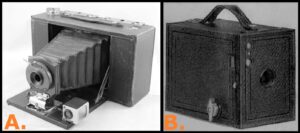
Figure 2. Kodak cameras of the Edwardian period. A) Kodak No.3 Folding Brownie, manufactured 1905 to 1915, used daylight loadable roll-film taking 3¼” x 4¼” (8.25cm x 10.80cm) negatives. B) Kodak Brownie No.2 ‘box’ camera, manufactured 1901-1933, used daylight loadable roll-film taking 2½” x 4¼” (6.45cm x 10.80cm) negatives.
Whilst Royal Mail letter post in the London area was collected and delivered between six and twelve times daily, from 7.30 a.m. to 7.45 p.m., speedy distant personal communication in the Edwardian period was inconvenient in parts of England outside London for on-the-day management of the GA’s excursions. Landline-based telephones, available from the 1880s, only became common in towns and barely in the countryside in the early 1900s; they were first installed in Bedford and Luton, the two principal towns of Bedfordshire, in 1896. Public phone kiosks, commonly small booths inside shops and public places (such as railway stations, and hotels), were also introduced in the early 1900s. For most of the cycling excursions the only readily available speedy form of communication then was the telegram – text messages printed, onto paper tape, by a land-line based teleprinter, cut and pasted onto a form usually delivered by a uniformed telegraph boy riding a bicycle. Their contemporary use is illustrated by the pedestrian June 1905 ‘Excursion to the Chilterns’ because as members alighted at Little Kimble Station awaiting them was “...a telegram to say that the Rev. E. C. Spicer, F.G.S. who was to have acted as Director, was unable (due to a bicycle accident!) to come.” (Woodward & Herries 1905, p. 147). However, by then bicycling was considered much safer than it had been in the 1870s to the 1880s when cyclists favored very large-wheeled (up to some 60”, or 152 cm) ‘ordinary’ or colloquially ‘penny farthing’ bicycles, typical of the Victorian scene
Bicycling
The single-speed (with three-speed hub gears after 1903) ‘safety’ bicycle, epitomized by the Raleigh 'roadster', of the 1890s, opened up cycling to reasonably wealthy people (McGurn 1987, chap. 5). The early roadsters (Fig. 3C), similar in appearance to modern hybrid bicycles, were over-engineered and ideal for use on England’s gravel and clay country roads. This robustness, with an associated performance disadvantage, came at a hefty 46 lbs (20.87 kg) for the Raleigh 'roadster'. By the late-1900s, the Raleigh ‘Modele Superbe’ only weighed 28 lbs (12.7 kg) and sold for a price equivalent to around £1,500 today; modern hybrid bicycles typically weigh around 25 lbs (11.34 kg), have 18 dérailleur gears, and are usually much cheaper!
Meanwhile, typical Edwardian period male cyclists’ outer clothing (Fig. 3A), excepting those who opted for cycling breeches and knee-length stockings, was similar to that worn by pedestrian excursionists, comprising a Norfolk or sports jacket, trousers, and leather brogues topped off by a trilby hat or cap – the latter sometimes sportingly worn with the peak facing backwards by cyclists. Female cyclists could wear ‘rational dress’ (Fig. 3B), of cycling bloomers and waistcoat, but commonly rode in ordinary clothes (Fig. 3D). Edwardian clothing manufactured from natural fibers (such as cotton, linen and wool) was heavier and more loosely fitted than today’s lightweight (mainly artificial fiber) clothing such as a fleece jacket and tights with a beanie or helmet.
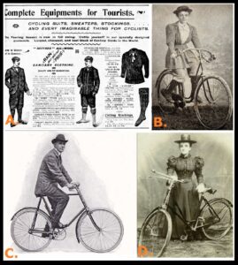
Figure 3. Bicycles and cycle clothing of the Edwardian period. A) Advertisement from the 1890s for men’s cycle clothing. B) Female cyclist in the 1900s wearing ‘rational dress’ outfit. C) Casually dressed male leisure cyclist of the mid-1900s riding a single-speed roadster bicycle. D) Casually dressed female leisure cyclist of the early-1900s with a single-speed roadster bicycle.
The Edwardian period saw the first ‘bicycle boom’ up to 1900, after which bicycles were a common feature of ordinary life (Watson & Gray 1978, pp. 122–129). By the 1900s, England’s roads were considerably improved for bicycle use compared with just a couple of decades earlier, particularly following lobbying by cycling organizations, most notably the Cyclists’ Touring Club and the National Cyclists’ Union. Such improvements were then supported at British society’s highest levels. Arthur James Balfour (1848–1930), Prime Minister of the UK (1902–1905) was President of the National Cyclists' Union, then the country's biggest cycling organization, with 60,000 members at its peak in 1899. In that same year, his speech at a celebration of the Union’s 21st anniversary recalled “...six Vice Chancellors for Cambridge (University)...are cyclists”. Further, Queen Victoria and Edward VII were keen cyclists, riding tricycles and happy to be photographed when doing so; the latter even appeared, but probably without official approval, in an advertisement for a popular brand of tricycles (Fig. 4). From the early 1900s up to the Great War, the middle classes were the mainstay of leisure cycling. However, bicycles were so cheap by 1920 that working-class commuters rode them. Therefore, cycling lost its upper-class and much middle-class support, except for a minority of the latter involved in cycle touring.
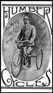
Figure 4. Humber bicycles advertisement dating from the early 1900s shows a smartly-dressed Edward VII riding a ‘Humber Beeston’ tricycle.
The Benefits
The cumulative consequences of the socio-political and technological changes, with increased leisure time and rising prosperity, widened book and map, camera, and bicycle ownership; this undoubtedly helped to encourage the exploration and recording of the British countryside, from which the GA’s mainly middle-class membership and activities benefited. The “...advantage of the bicycle was its range. A fit cyclist could cover much more ground than a carriage without a change of horses, which was good for fifteen miles (24.14 km – the distance covered on the first cycling excursion) at most. A significant proportion of the population was now truly and fully mobile, for the first time in history” (Nicholson 1983, p. 4). In the Edwardian period, there were none of the personal portable entertainment, communication, and field recording systems we have today existed, just cumbersome clockwork-powered gramophones playing recorded music on 7” and 10” (17.78 cm and 50.8 cm) shellac disks (or ‘records’). The excursionists usually carried a small shoulder bag containing their MCGA notice, note-book and pencil, and sometimes a film camera to record their observations; perhaps, not too dissimilar to today’s leisure cyclists albeit with their digital counterparts.
The Original Excursions
Some Pedestrian and Cycling Excursions
The GA’s Edwardian period pedestrian excursionists were usually expected to walk three to six miles (4.8–9.6 km). On lengthier excursions, up to around 15 miles (24.1 km), they commonly rode in horse-drawn transport. However, there are some accounts of remarkably (at least by today’s standards!) lengthy pedestrian excursions. For example, on the June 1889 ‘Excursion to Totternhoe & Ivinghoe’ “Stan bridge Ford Station, near Dunstable, was the place of meeting, and in the morning a walk of twelve or thirteen miles [19.31 km or 20.92 km] was commenced here, two waggonettes conveying most of the ladies.” (Hopkinson 1889, p. lxxv); the concession of horse-drawn transport for the female participants seems condescending, but they were obliged to wear clothing inappropriate for long, muddy country walks. It is noteworthy for using both a branch line (although that would have been connected from the mainline Luton Station) and a different mainline station, at Tring, for the return trip to London. A notable contributor to that excursion’s discussions was the antiquarian Worthington Smith (1835–1917), author of the classic ‘Man, the Primeval Savage’ (Smith 1894), who today is recognized for establishing the scientific study of the Paleolithic. Meanwhile that excursion concluded with “...the stroll along Duncombe Terrace (by permission) was the most enjoyable portion of the day's walk...a descent was made to the village of Aldbury, where tea was partaken of, after which the walk was continued for another mile down the valley to Tring Station” (Hopkinson 1889, p. lxxx). The pedestrian June 1895 ‘Excursion to Totternhoe’ used the same branch-line railway; much focused on the area’s Chalk quarries and their history, such as “There appears to be no history to these quarries, but they must have been worked almost as early as, perhaps even before, the Norman Conquest, and the stone was certainly in request in early days both for interior and exterior decorative work. Dunstable Parish Church may be mentioned...” (Hill 1895, p.193). The May 1894 pedestrian ‘Excursion to Luton, Caddington & Dunstable’, of around nine miles (14.48km) at most but hilly, is almost unique in that no report was published, although it did take place; its MCGA notice (Fig. 5) is unusually well illustrated and the route is so well described it could today be traced in its entirety, if it were not for modern development often built across it – it is part-used for one of the new geotrails.
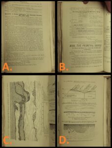
Figure 5. Excursion notice in the May 1894 Monthly Circular of the Geologists’ Association. This is the notice, and only official record, for the ‘Excursion to Luton, Caddington & Dunstable, Saturday, May 26th 1894. A) The first page provides details of the excursion arrangements and a description of the route. B) The second page completes the list of references, but note the book advertisement for ‘Man the Primeval Savage’ – perhaps its author, who was on the excursion and gave a talk, was hoping to sell a few more copies! C) A geological sketch section of the Quaternary deposits within an excavated Chalk doline near Caddington, south-west of Luton from the book ‘Man, the Primeval Savage’. D) Three geological sketch sections of the Quaternary deposits near Caddington, south-west of Luton from the book ‘Man, the Primeval Savage’.
The April 1899 MCGA notice for the first dedicated cycling,‘Winchfield to Wokingham’, excursion informed participants “The route taken and the distance to be traversed will to some extent depend on the state of the roads. In no case will the distance exceed fifteen miles”; they had only five hours to complete their at most 21.14 km-ride, examine geological sections, and have tea. The notice for the second such, May 1899 ‘Bushey to Harrow Weald’, excursion concluded the “Train may be taken...at Harrow, leaving thirteen miles as maximum run. Those who wish a longer ride may meet...at Brondesbury Station...and ride out to Bushey,” but only 1½ hours was allowed for that almost 17 mile (27 km) ride! The notice (Salter 1899) for the final 1899, July ‘Chilterns Hills’, cycling excursion mentions a party-rate train-fare of around £25.00, with bicycle carriage each way around £6.85, in today’s money making it a somewhat expensive outing; they also had just five hours to complete their excursion.
The May 1903 ‘Dunstable Downs’ excursion was, despite the quite challenging, hilly 17½ mile (28.16 km) route, well attended by 15 cyclists. Run in conjunction with the Hertfordshire Natural History Society, probably because the excursion Director had been its Secretary, its participants were interested in “...the picturesque village of Aldbury, which is situated in a pretty valley cut out of the Chalk, after its escarpment commences, by a stream no longer flowing. The old timbered houses, and the stocks and whipping-post still standing by the side of the village pond, attracted attention…” (Hopkinson 1903, p. 170) and local landscape geomorphology. The year’s second, ‘Aldershot district’, 10-mile (16.09-km) cycling excursion in June had HW Monckton (then GA President) as Director and could have been extended, although there is no evidence that it was, to and from central London to a lengthy 32 miles (51.50 km) each way (Monckton 1903). The April 1905 ‘Flitwick & Silsoe’ excursion notice was for “Cyclists and Walkers”. The June 1905 ‘Redhill, Woodhatch & Reigate’ MCGA excursion notice indicated “This excursion is equally suitable for cyclists.”. Similarly, the May 1905 ‘Bedford’ MCGA excursion notice ended with “Cycles could follow the route.” but its report recorded its pedestrian excursionists “...were driven (in horse-drawn carriages) first of all through the town, and about a mile northwards to Mr. Charles Franklin's pits by the waterworks.” before eventually visiting one of the UK’s most important archaeological sites, Biddenham Pit; there “...James Wyatt found the first palaeolithic flint implements that were obtained in this country...” (Woodward 1905, p. 142). Its notice instructed the excursionists to “Meet Excursion Secretary under the Clock at 10 latest” at St. Pancras Station – rather a cliché! It was somewhat repetitious of the July 1888 ‘Excursion to Bedford & Clapham’ (Cameron 1888) with the same starting point although brick-making in the area was then its chief concern. For the May 1908 ‘Oxford, Stonesfield & Fawler’ excursion, “The party, numbering 35, travelled by brake and bicycle...” (Bayzand 1908, p. 25). For the April 1909 ‘Footscray & Orpington’ outing “...in order to avoid an unduly tiring walk... The party therefore consisted of cycling members...” (Dibley 1909, p. 196) indicating on this penultimate cycling excursion their raison d’etre. Horse-drawn carriages, as on the July 1914 ‘Soulbury, Stewkley & Wing’ excursion, were being used right up to the Great War; anyway, “Driving on to Stewkley, the party halted in the village for lunch and a hasty examination of the beautiful Norman church. Then two brickfields in Kimmeridge Clay were visited to the south-west of the village.” (Morley Davies 1914, p. 90). Local afternoon hospitality after luncheon was provided at “Warren Farm, where they were most hospitably entertained... The classic section here displayed - the most northerly exposure of typical Portland and Purbeck beds…” (Morley Davies 1914, p. 91). Whilst on that excursion “...the small escarpment of the Aptian...was noticed, with a spring at its foot, near the entrance to Liscombe Park” (Morley Davies 1914, p. 90), they seemingly ignored the splendid water trough fed by that spring, which is now included in the relevant geotrail.
The Excursion Literature
There are compilations of the GA’s excursions before (Sherborn & Holmes 1891) and during (Monckton & Herries 1909) the Edwardian period. Several papers (Kennard 1947; Middlemiss 1989; Robinson 1990; Sweeting 1958; Watts 1909; Woodward 1894) have reviewed the PGA for coverage of the excursions. Green (1989) recorded four cycling excursions and Sweeting (1958) at least eight for 1899–1905. Burek & Kolbl-Ebert (2007) suggested their abandonment by 1907. Only from close scrutiny of notices and reports, as for the April 1904 ‘Farnham gravel pits’ excursion, on which “...members assembled at Farnham Station, and proceeded by carriage, motor, or cycle...” (Monckton 1904, p. 409), is a cycling element discernible; that excursion is also the earliest on which a motor vehicle is recorded. The PGA reports repeated much of the MCGA’s information, supplemented by accounts of observations made on the day. They notably include social (commonly luncheon and refreshments arrangements, and any discussions) and weather information. They rarely give the number and type of excursionists and their transport mode(s).
The MCGA was printed in the pocketable, at 6” x 9” (15.2 cm x 22.9cm), octavo format (Watts 1909, p.134) when the cycling excursions were ridden. It has been noted that whilst “...often regarded as ephemeral publications and quickly discarded...are a fruitful source of information when planning a field trip.” (Himus 1954, p.8). They were useful, with background geological information and references, both for excursionists’ preparations and in the field. They necessarily covered transport, group meeting, and refreshment arrangements. Before, particularly Ordnance Survey (OS), map grid references locating meeting places relied upon detailed directions; for example, the April 1909 ‘Footscray & Orpington’ excursion’s notice advised cyclists to meet the Director “...at the Foots Cray Chalk Pit...situated on the Farringdon Road, about ¼-mile to the east, when this road intersects the road leading to St.Paul’s, St.Mary’s Cray, and Orpington.”. Very few, as for the 1905 ‘Flitwick & Silsoe’ excursion, incorporated topographical (Hopkinson 1905, p.112) and/or geological maps, commonly reproduced from official sources. Geological cross-sections, such as for the July 1885 ‘Ampthill & Bedford’ (Fig. 6A) and June 1895 ‘Totternhoe’ (Fig. 6B) excursions, and/or stratigraphical columns were occasionally incorporated.
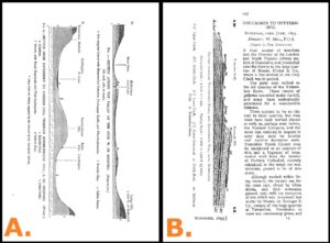
Figure 6. Extracts from two excursion reports in the Proceedings of the Geologists’ Association. A) Geological cross-sections (provided by courtesy of the Geological Society of London) from the report of the ‘Excursion to Ampthill and Bedford, Saturday, July 25th, 1885’. B) First page and geological cross-section (probably from the Geological Survey of England & Wales) from the report of the ‘Excursion to Totternhoe, Saturday, 22nd June, 1895’.
Theoretical Underpinning and Analysis of the Five New Geotrails
Cyclists’ Geotrails as Trails
Whilst the Edwardian period excursions were mainly guided walks with a few cycle rides, the new geotrails are totally self-guided and thus self-paced. On the former trail type, participants are led to the various locations and features to be observed and interpretations, are pointed out by a leader (or ‘Director’ on the GA’s excursions). On the latter trail type, participants follow the route themselves and make observations without recourse to a knowledgeable expert. The original GA excursions were always undertaken in the company of like-minded individuals with a, often passionate, interest in and usually much knowledge of geology – much like today’s GA field meeting participants! The new geotrails’ users can either be alone or in small family/social groups and will probably have some interest in and knowledge of geology. Hence, any new geotrails must somehow bridge the gap between the needs of two distinct types of excursionists.
Several authors with varied experience in, and approaches to, interpretive provision have published overviews (Aldridge 1975; Carter 1997; Hose 2000a, 2006a, 2006b; Regnier 1994; STB 1993; Trapp et al. 1994; Veverka1994) and practical/theoretical guidelines (Ham 1992; Knudsen et al. 1995; Beck & Cable 2011; Tilden 1977) on the matter – some of these have become classic and are still relevant volumes. Similarly, there are several specifically on writing interpretive texts (Heintzman 1988) and designing publications (Carter et al. 1993; Zehr et al. 1991). Geotrails have been defined as “A usually way-marked guided or self-guided route around a geological and/or geomorphological site on which points of interest are indicated and explained.” (Hose 2021, p. 250); for the new geotrails the ‘site’ is not as restricted as the definition might suggest and perhaps on reflection should be replaced by ‘area’.
Cycle Trail Theory and Practice
Trails in general can be regarded as self-paced structured distance-learning packages (Keene 1995). In selecting and refining trail routes for leisure cyclists, such as the users of the new cyclists’ geotrails, particular care must be taken to select roads with relatively little vehicular traffic, to maximize cycleways and employ off-road sections along well-maintained and preferably well-signposted tracks (Downward & Lumsden 2001). This approach was adopted in England’s most detailed geotrail specifically developed for cyclists, especially mountain-bikers, the ‘Wheels to the Wild’ (Pickett 2006), a 50-page guide-publication for the North Pennines Area of Outstanding Natural Beauty and Geopark, which is long out of print and only available in hard-copy, spiral-bound, A5 format. The document covers the full route in well-illustrated mapped stages along with three ‘taster’ day-routes across wild moorland and along scenic limestone valleys. Such trails in general should pay attention, as well as to a route’s aesthetic appeal, to possible refreshments and comfort break facilities; without considering these, trails are unlikely to appeal to families and particularly female users. There have been several summaries of the needs of such leisure cycle tourists and how they can be met, the most practical of which is Anon (undated) and for theoretical coverage is probably Lamont (2009). Hose (2018b) considered the development of cycling trails with geoarchaeological interest in the UK, specifically in Bedfordshire and Hertfordshire, and more widely in Europe.
The preparation of self-paced learning trails must consider the nature of the target user(s), the focus or level of specialization, and participation or level of engagement. Their interaction, and the types of trail publication, can be summarized (Fig. 7). The geotrails’ main target users are leisure cyclists, rather than dedicated sports or club members, riding either alone or in small family/social groups; as such, they are at the lower end of interest in geology of the typical ‘casual/recreational user’ (Hose 2021, p. 248). Further, they are unlikely to be major users of dedicated cycling GPS hardware and smartphone applications; instead, they are very likely to use leisure cycling leaflets and booklets in both printed and online formats. The focus of the five new geotrails, constrained by the need to adopt the route and locations of the original excursion(s), is also best holistically set because one of the main tenets of interpretive provision is to present material to users that somehow relates to their experiences, knowledge, and understandings (Tilden 1977; Beck & Cable, 2011). Since many geotrail users will have little or no geological education, some content should cover basic concepts and include social and local (in these specific cases, aspects of Edwardian period) history. Differences in the survival and accessibility of places between the original excursions and the new geotrails could help to inculcate a sense of shared loss and reinforce an interest in the need for geoconservation.

Figure 7. Self-paced trails summary cube-plot, showing the interrelationships between the nature of the target user(s), degree of trail specialization, and user engagement level. Plotted on it are the characteristics of the five new geotrails.
Trail Guide-Publication Analysis
The layout of trail guide-publications such as leaflets consists of three elements – text, illustrations (individual drawings, logos, maps and photographs), and white space (the background, which can include an overall image, on which the text and graphics are overlain). In attracting users to select and read leaflets, the recommended proportions vary from equal thirds (Carter et al. 1993) to 50% illustrations / 37.5% text / 12.5% white space (Hose 2000a, 2006b). Commonly, guide-publications such as leaflets, even within the same series, exhibit some variation in the ranges because of the need to provide sufficient information for users to follow the trail route with adequate explanatory material within the format constraints. Such publications should include a route-map, but there are contradictory views on the best type of map (standard topographic, photo-map, orthorhombic projection). Commonly for cycling trail guides, annotated extracts of topographic OS 1:50,000 maps are used for mainly road-based routes and 1:25,000 for off-road routes; they are not always reproduced at true scale.
Text readability and comprehension guidelines (Carter et al. 1993; Hose 2000b; Zehr et al. 1991) indicate a reading age of around 13 years (school grades 7-8 and roughly tabloid newspaper readership level) is ideal for users with average education. This is achieved by employing short words and sentences, together with limiting technical terms, but this can be difficult to accomplish when quoting from historic publications and when explaining complex concepts. Text readability for English is measured by the ‘Flesch Reading Ease’ and ‘Flesch-Kincaid Grade Level’; both tests are available within Microsoft ‘Word’. Detailed analyses and comparisons of these measures with other reading and comprehension tests (Hose 2000) reveals their benefits and pitfalls when applied to short and historic text samples – odd results can be calculated! For the Flesch Reading Ease a score of 51–60 (school grades 10–12) suggests fairly difficult, that is quality, writing; a score of 30–50 (college grade) lies within academic writing. Probably Flesch Reading Ease scores around 50 are most likely achievable in the new geotrails.
The Five New Geotrails
Their Geology
A summary of the PGA from their inception in 1859 to the 1960s concluded “...how little the Association's concerns have changed in the course of 130 years. In 1859-61 we find our members interested in the Jurassic and Cretaceous rocks of southern England, the Gault and Chalk, the Tertiaries around London, the Isle of Wight, Quaternary gravels, flint...” (Middlemiss 1989, p. 65) aptly fitting the geology of the area in which the five new geotrails (Fig. 8) are located. The surface rocks of Bedfordshire (Fig. 9) and its adjacent counties of Buckinghamshire (to the west) and Hertfordshire (to the east and south) are chiefly of Jurassic and Cretaceous age. They form north-east/south-west trending belts of alternating narrow ranges of (mainly Lower Greensand sandstones and Chalk) hills separated by broad clay plains. In Bedfordshire’s far south-west and extending into Hertfordshire Eocene (Reading Formation) strata outcrop. All are mantled by a series of glacial, fluvio-glacial, and riverine clays, silts, sands and gravels of Quaternary and Recent age. Included in these, and usually eponymously termed ‘brickearths’, are loess deposits commonly preserved in small dolines and other depressions in the Chiltern Hills immediately south and west of Luton; they are noteworthy for their Paleolithic artefacts. Some of the glacial clays are sufficiently thick in southern Bedfordshire to form prominent ridges between the Chiltern Hills and the Greensand Ridge. Elsewhere they infill pre-glacial river valleys.
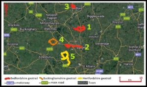
Figure 8. Location Map of the Five New Geotrails, Shown by County – Adapted from the map on the GeoConservationUK publications website, and reproduced by courtesy of GCUK.
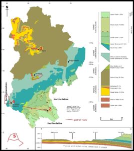
Figure 9. Bedfordshire geology map and the five new geotrails. The numbered geotrail routes are: 1. ‘Flitwick & Silsoe’; 2. ‘Luton to Standbridgeford’; 3. ‘Bedford to Bromham’; 4. ‘Leighton Buzzard & Stewkley’; and 5. ‘Tring to Berkhamsted’. (The map and cross-section are adapted from British Geological Survey DiGMapGB-50 data and copyright in the original is reserved by the National Environment Research Council, United Kingdom).
At the time of the original excursions, “London geologists then had fine sections at their doors... It would be a long list that would include all...” (Kennard 1947, p. 274) and part of the geoconservation impetus to research the new geotrails was to assess the survival and accessibility of locations visited by past excursionists. The requirement for the geotrails to be a form of sustainable geotourism (Hose 2012) meant that bicycles were ideal for transport; further, using public transport was a necessary restriction and possible because the original excursions relied on the London-centered railway network.
Then, as now, three main railway passenger lines (Fig. 10) ran roughly north–south across the three counties, the London Euston to Birmingham (West Coast Mainline), London St Pancras to Derby (Midland Mainline), and London Kings Cross to Newcastle (East Coast Mainline). The first route was ideal for excursions to southern Bedfordshire to examine the Chalk strata of the Chilterns hills, especially around Totternhoe and the Dunstable Downs, and the Lower Greensand strata around Leighton Buzzard. The second was ideal for excursions to central (Ampthill and Flitwick) and northern Bedfordshire (Bedford and Clapham) to examine the county's various Jurassic and Cretaceous (including Lower Greensand) deposits. The third route was ideal for excursions to eastern Bedfordshire (Sandy) to examine the Ampthill Clay, Oxford Clay and Lower Greensand strata.
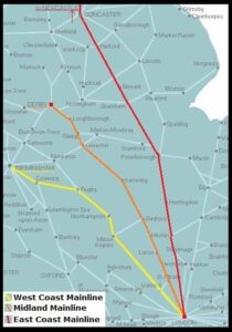
Figure 10. Map of the mainline railways crossing the area of the new geotrails. This modern map shows the three main railway routes employed by the Geologists’ Association for its excursions in the ‘Edwardian period’.
Their Location and Physical Characteristics
All five geotrails are located some 35–50 miles (56.3–96.5 km) north of London. They are readily accessible by public transport, ideally by train although several are on public-service bus routes. They follow low-traffic roads and segregated off-road routes. Their selection followed a vetting process that assessed the survival of the original routes and localities visited together with the safety of the routes, particularly with regard to motor vehicles. Several initially promising geotrail routes were scrapped following field assessments. In Hertfordshire, for example, the Hitchin, Hemel Hempstead, Letchworth, Stevenage and Welwyn areas were eventually excluded because most, if not all, of their localities had been lost to development and their roads had much high-speed and large vehicular traffic. In Bedfordshire the Leighton Buzzard area, much visited by the GA, was discounted because it is under rapid and modern urban expansion, and any new geotrail would quickly become out-of-date. Further, routes such as that of the July 1885 ‘Ampthill & Bedford’ Bedfordshire excursion, were excluded because strictly they lay outside the Edwardian period time-frame and their routes originally followed what are now roads with much high-speed vehicular traffic. The routes of the five new geotrails were selected because they could all be ridden on low-traffic roads, cycleways and off-road sections.
The geology of the ‘Luton to Standbridgeford’, ‘Tring to Berkhamsted’ and ‘Leighton Buzzard & Stewkley’ geotrails share common elements; the other two have disparate unique elements, with the Bedford-based one having some emphasis on riverine geomorphology. All but one, the ‘Tring to Berkhamsted’, are circular routes. Their lengths vary from some 9 miles (14.5 km) to 15 miles (24.1 km). All, allowing for site visits, can be completed within two to four hours. All but the ‘Luton to Stanbridgeford’ geotrail have refreshment and/or comfort break stops approximately half-way round. The ‘Bedford to Bromham’ and ‘Luton to Stanbridgeford’ geotrails are on relatively level terrain; the latter particularly so because much of it follows the route of an abandoned railway line. The ‘Leighton Buzzard & Stewkley’ and ‘Tring to Berkhamsted’ geotrails have some moderately challenging hilly sections; their routes were adjusted where possible to reduce unnecessary hill climbs! The slightly challenging ‘Flitwick’ geotrail necessarily follows a well-documented and originally mapped (Hopkinson 1905, p. 112) excursion; its only deviation is to avoid a dangerous road crossing. All were test ridden by the author on either a small-wheeled single-speed (Fig. 11A) or a full-size 7-speed folding bicycle (Fig. 11B) to ensure they were within the capability of typical adult leisure cyclists. Two geotrails, the ‘Bedford to Bromham’ and ‘Luton to Stanbridgeford’, could be cycled with ease by mixed parties of adults and children. Indeed, the latter’s route is similar to that promoted since 2008 as the ‘The Luton and South Beds Way’ (https://vdocument.in/south-beds-and-luton-way-cycle-leaflet-ncn6.html?page=1), a 23-mile (37 km) cycle route along part of National Cycle Network Route 6; the latter, managed by the charity SUSTRANS, is part of a UK-wide 12,739-mile (20,501-km) network (https://www.sustrans.org.uk/national-cycle-network) of waymarked paths and routes for walking, cycling, wheeling and exploring outdoors. Meanwhile, with public-service buses along part of their routes, both the ‘Bedford to Bromham’ and ‘Luton to Stanbridgeford’ could easily be walked in around three to four hours; the others could be undertaken as car drives with limited safe parking, although this is discouraged.
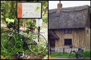
Figure 11. Bicycles used to assess the routes of the new geotrails – Folding bicycles were employed because they could be easily transported, as a matter of good sustainable tourism research practice, to the start points by public transport. A) Full-size hybrid, 7-speed, folding hybrid bicycle parked against a 2010s interpretive panel in Folly Wood car-park on Flitwick Moor, Bedfordshire; placed there by the Wildlife Trust for Bedfordshire, Cambridgeshire and Northamptonshire, it is focussed on key attractive species and a general account of the nationally significant fen and wet woodland habitats. B) Small-wheeled, single-speed and lightweight folding bicycle stood in front of a cottage in Flitwick, Bedfordshire; the cottage’s site marked on the nineteenth century Ordnance Survey maps was helpful in locating a contemporary excavation now recorded in the street nameboard as ‘Gravel Pit Road’.
The New Geotrail Guide-Publications in General
All of the geotrails have a guide-publication formatted as a full-colored doubled-sided, tri-folded, A4 landscape ‘leaflet’; additionally, separate briefing or explanatory, single-sided A4 landscape, sheets were also prepared for some of the geotrails, but only made available for the ‘Leighton Buzzard & Stewkley’ geotrail because the content of the others is under review. The geotrails are available as PDF files from the websites of ‘GeoconservationUK’ (https://geoconservationuk.org) and eventually some of its member groups as well as via links from websites such as that for The Icknield Way Trail (http://icknieldwaytrail.org.uk/route/bedfordshire/ and http://icknieldwaytrail.org.uk/route/hertfordshire/). For sustainable geotourism purposes, because they do not need to be printed, they are especially intended for easy use on smartphones and tablet PCs.
The guide-publications have varied layouts, typography and content because they were initially conceived as part of a scheme to assess their user attractiveness and communication effectiveness through workshops and user feedback –impacted by the COVID pandemic. Further, that same scheme sought to demonstrate, at a time when funding for small interpretive projects has been limited (Whiteley & Brown 2012, p. 678), that good-quality guide-publications can be produced with the most basic of software and hardware. All were prepared using commercial and free basic word processing (such as Microsoft ‘Word’ and Libre ‘Office’) and imaging (such as Microsoft ‘Paint’ and ‘Photos’) software. Following good typographical practice, no more than three fonts (and sizes and embellishments) are used; Arial, either Calibri or Verdana, and Times New Roman. Achieving page-layout balance (the placing of illustrations and text blocks) was challenging because the guide-publications are designed to be viewed either as a whole or as single pages; the latter, with the individual page aspect-ratio (roughly 1:2 and near the standard 16:9 smartphone screen format) is particularly ideal for smartphone and tablet PC viewing.
As much as possible, the geotrail routes in the guide-publications are presented in the words of the original excursion Directors. Their quotations are taken from the PGA reports and, as such, are, in the engaging writing style of Edwardian authors, aimed at non-geologists. They may seem somewhat verbose today, and with local detail that is not normally found in modern geological papers. It is a, perhaps depressing, truism that “There is a tendency towards papers which are more technical and specialized, and certainly more quantitative in approach. The language has become leaner and less wordy, through the economic pressure of the cost of printing; the endearing asides of the old authors have largely disappeared...” (Middlemiss 1989, p. 65).
Necessarily, all include a map (1:50,000 OS) extract on which the route is marked but they vary in format, and slightly in reproduced scale, to take account of the shape of the specific route (Fig. 12). That for the ‘Flitwick & Silsoe’ geotrail (Fig. 12A) is similar in its approach, with the route marked on a 1:50,000 OS map extract map with images around it of its geosites, to that adopted by the Peak District National Park Authority for its series of cycle trails (www.visitpeakdistrict.com/cycleroutes) originally published in 2011 as PDF files; these have now been replaced by downloadable GPX files and text route descriptions. Although the original GA cycling excursions coincided with the new-found ease of photography and the availability of inexpensive postcards, they are not recorded in these media. However, contemporary photo-illustrations for excursion areas, as for the 1905 ‘Flitwick & Silsoe’, are available. Consequently, a mix of contemporary (reproduced in their original sepia and black & white form) and modern (usually full-color) photo-images are used in the guide-publications. Full-color photo-images are either reproduced naturalistically or vividly enhanced (similar to 1960s and 1970s John Hinde postcards) to improve the appeal of some locations. Contemporary newspaper cuttings and advertisements, together with some commercial artwork are also used.
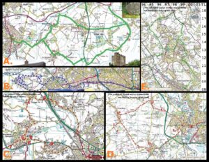
Figure 12. The Route-Maps of the New Geotrails Guide-Publications – The Ordnance Survey 1:50,000 map extracts are shown for the five geotrails: A)‘Flitwick & Silsoe’; B)‘Luton to Standbridgeford’; C)‘Bedford to Bromham’; D)‘Leighton Buzzard & Stewkley’; and 12E.‘Tring to Berkhamsted’.
All the guide-publications have a common promotional and graphical strap line emphasizing their initial dependence on rail travel; a typical London Midland and Scottish Railway (LMSR) station platform signboard of 1923–1947 in the classic ‘blood and custard’ color scheme is employed. All have an illustrated account of their railway station start point. Two of the new geotrails, the ‘Flitwick & Silsoe’ and ‘Bedford to Bromham’, have a ‘life in Edwardian times’ introduction and share a common background emphasizing the LMSR theme; the former is the only one with a whole-page route-map surrounded by images. The two non-Bedfordshire geotrail guide-publications share a common page-layout and background approach that only lightly emphasizes the LMSR theme. The ‘Luton to Stanbridgeford’ shares elements of the two other page-layout themes. These differences can be seen when their front pages are compared (Fig. 13).
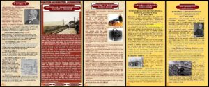
Figure 13. Introductory pages of the new guide-publications. The first pages of each of the five geotrails, for purposes of comparison, are shown: A)‘Flitwick & Silsoe’; B)‘Luton to Standbridgeford’; C)‘Bedford to Bromham’; D)‘Leighton Buzzard & Stewkley’; and 13E.‘Tring to Berkhamsted’. Note the similarity in layout and color-scheme between 13A and 13C and also 13D and 13E; all carry the common railway signboard logo.
The Specific Geotrail Guide-Publications
The first prepared Bedfordshire, ‘Flitwick & Silsoe’, geotrail (Hose 2018a) starts and ends at Flitwick Station on the Midland Mainline. The original excursion had walking and cycling Directors, both of whom were well-respected local naturalists and geologists; its Excursion Secretary was also a keen cyclist. Its partly text-rich guide-publication employs a mix of modern photo-images and 1900s–1920s postcard images (Fig. 14A1, 14A2) arranged around a map, unlike the other geotrail guide-publications. It has a brief illustrated biography of John Hopkinson and an opening focus on ‘life in Edwardian times’; the latter asks the reader to imagine what it would have been like living a century earlier compared with the present. There is some pre-existing on-site interpretive provision on Flitwick Moor (Fig. 11A) focused on wildlife interest with some mention of the local mineral-water industry; for the latter, in a blue font, the guide-publication notes from the PGA excursion report that “The walking party visited the source of the Flitwick mineral springs. Most of the members tasted the water...”. Its most interesting locality is a purported seventeenth century gold mine which the modern account, in a black font, reports as “A flooded pit, south of the footpath off the Flitton Road, is all that remains of the 1680s site – claimed by Charles II. The 1820s map (overleaf) shows the mine marked in a way that pleased John. Of course, NO gold was ever found here!”. Some of its geology sites, such as at Gravel Pit Road in Flitwick (Fig. 11B), survive in name only.
The second prepared Bedfordshire,‘Luton to Stanbridgeford’, geotrail starts at Luton Station on the Midland Mainline. It encompasses the routes (now partly a guided busway and a wholly dedicated cycleway) of the railway that carried the original excursionists to Dunstable and Stanbridgeford, together with parts of 1881, 1889, 1894 (Fig. 5A) and 1895 pedestrian (none were ever ridden by late-Victorian cyclists) GA excursion routes. Its guide publication is highly descriptive of its geosites, mainly railway cuttings and quarries in the Chalk, with photo-images, such as of Totternhoe Castle (Fig. 14B), vividly enhanced; a similar approach to the author’s 2012 Buckinghamshire cyclists’ geotrail (downloadable from the Bucks Geology Group website: http //:bucksgeology.org.uk) along the route of the abandoned Bradwell to Newport Pagnell railway (Hose 2021, fig. 10.19). It emphasizes the history of its branch-line railways; for example, on the front page it reports “Dunstable was once served by two branch-line railways to Leighton Buzzard and (via Luton) Welwyn, respectively joining it to the original London & Birmingham and London to York main railway lines. The private lines were separately owned and joined just east of Dunstable North station…” Like its GA forerunners, it visits significant archaeological sites, from a Neolithic/Iron Age enclosure to a Norman motte-and-bailey castle. Unlike the other new geotrails it notes major wildlife sites, the Sewell (railway) Cutting and Totternhoe Knolls, along its route. At the former “...the steep grassed banks are cut into the Zig Zag Chalk Formation; this supports many wild flowers, including various orchids.” and the latter is “a nature reserve and SSSI on Medieval stone workings that mainly exploited the Zig Zag Formation, especially for the Totternhoe Stone.” - both are noteworthy sites, in late spring and summer, for butterflies; particularly of note are those species, due to the calcicole nature of their specific food-plants, associated with chalk and limestone sites such as the ‘Chalk Hill Blue’ (Lysandra coridon), the ‘Common Blue’ (Polyommmatus icarus), the ‘Dingy Skipper’ (Erynnis tages), the ‘Marbled White’ (Melanargia galathea), and the ‘Small Blue’ (Cupida minimus). The major wildlife site of Flitwick Moor SSSI, visited on the ‘Flitwick & Silsoe’ geotrail for its bottled spring-water interest is not described in the guide-publication mainly because there is, as also at the Sewell Cutting and Totternhoe Knolls, an adjacent wildlife interpretive panel (Fig. 11A). The inclusion of such wildlife information and the necessary identification illustrations, would take up space not available in the two-page guide-publications. Further, they are season specific and it has long been recognized that geotourism at the participant level, such as the five geotrails, is “‘recreational geology’ that, unlike many forms of countryside recreation, is not limited by the seasons” (Hose 1996, p. 211). Meanwhile, the Sewell Cutting is a Local Nature Reserve and the Totternhoe Knolls (like Flitwick Moor on the ‘Flitwick & Silsoe’ geotrail) is a Site of Special Scientific Interest (SSSI). Both, designated for their flora and fauna but not their geology, are managed by the Wildlife Trust for Bedfordshire, Cambridgeshire and Northamptonshire.
The UK’s 46 non-governmental Wildlife Trusts, such as that for the three counties as its website (https://www.wildlifebcn.org/about-us) indicates, have little obvious and professed interest in either geoconservation work or promoting geological exploration through their site-specific publications. Indeed, geoconservation in the UK’s non-governmental sector is chiefly promoted and undertaken by the member groups of GeoConservationUK (https://geoconservationuk.org) and the Geology Trusts (http://www.thegeologytrusts.org) (Whiteley & Brown 2012). They have even produced a few geology trails for cyclists. For example, the Bucks Geology Group’s ‘Whiteleaf Hill to Dunsmore circular Geo-Cycle Trail’ (http://www.bucksgeology.org.uk/pdf_files/Geo-cycle-trail-Whiteleaf-Hill-Dunsmore-circular-route.pdf) is a four-page, double-sided and triple-folded A4 leaflet with a plain background, making it ideal for being cheaply printed by users; the 7.5km route is described in somewhat technical language but also covers several archaeological sites and some natural history content, for example, “This path is part of the Upper Icknield Way...you cycle through woodland scrub which represents a progression from the open chalk grassland to mature woodland. Scrub species...valuable shelter and food for insects and birds. Keep an eye out for the pretty Speckled Wood (Pararge aegeria) and Peacock (Inachis io) butterflies…”. Of course, unless either the user can recognize the named species or carries a field-guide, the information is of little use. However, unlike the great majority of the Wildlife Trust leaflets it does attempt some subject-matter crossover between geology and wildlife.
The third prepared Bedfordshire, ‘Bedford to Bromham’, geotrail follows the original 27th May, 1905 excursion’s route (Woodward 1905); as suggested it could be in its MCGA notice, although all the excursionists seemingly rode in carriages and walked, it is now cycled. Its start and end point is Bedford Station on the Midland Mainline. Its guide-publication, like that for ‘Flitwick & Silsoe’, has a strong social history element about life in the Edwardian period. Like its GA forerunner it also describes and visits a nationally significant Paleolithic site, Biddenham Pit SSSI, rather emphasizing ancient and modern river geomorphology. Designated for its geological interest, it is managed, with advice from Natural England (a statutory national nature conservation body), by the local GeoConservationUK member group, The Bedfordshire Geology Group (http://www.bedforshiregeologygroup.org.uk). The route’s first site, not visited on the original excursion, is a painted gable wall advertisement for a monumental stonemason. One of its best and well-preserved geosites, Franklin’s Pit, cannot be safely visited because it is now a gun-club firing range! Quotations, in a mid-blue font, from the original excursion report (Woodward 1905) are employed to both describe the route and it various sites; for example, “The party now proceeded to Oakley Bridge, where Mr R. Hill drew attention to a flood-mark 6ft. [c.2 m] above the floor of the bridge; date, November, 1823. After crossing the Ouse the party were driven through Bromham, where they dismissed the vehicles…”. Explanatory notes, in a red font, such as “The red bricks the pit produced were used to build in about 1899 ‘Franklin’s Cottages’...they originally housed some of its, probably managerial, workers. They stand above the site of the former brickworks, which opened in about 1869 and had closed by about 1940.” and “The site of the quarry, opposite the Brookside Caravan Park, has been filled in and returned to farmland.”, describe what can be seen today following landscape changes since the original excursion.” Modern color photo-images (Fig. 14D), in a naturalistic style, illustrate the various sites.
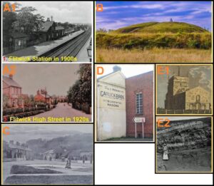
Figure 14. Selected images from the new geotrails guide-publications. A) ‘Flitwick & Silsoe’ employs some early twentieth century postcards, of Flitwick Station (14A1) and Flitwick High Street (14AB), to show what the locations looked like in the year of the excursion, 1905; B)‘Luton to Standbridgeford’ employs entirely modern photo-images, such as of Totternhoe Castle, vividly enhanced to replicate an image style popularized by the postcards of the John Hinde company in the 1960s and 1970s; C)‘ Tring to Berkhamsted’ employs early twentieth century postcard, such as of Aldbury, images and modern photo-images. D) ‘Bedford to Bromham’ employs naturalistically reproduced modern images, such as of a gable-end wall painted advertisement; and E) ‘Leighton Buzzard & Stewkley’ employs modern and historic images such as a colored nineteenth century lithograph of Stewkley church (E1) and a 1914 photograph from the Carreck Archive of Warren Farm Pit (E2).
The fourth and mainly Buckinghamshire-based, ‘Leighton Buzzard & Stewkley’, geotrail follows that of the horse-drawn carriages on 11th May, 1901 (Davies 1901). Its start and end point is Leighton Buzzard Station on the West Coast Mainline. Like its GA forerunner, the geotrail route visits, but also adds some, significant historical sites; its guide-publication has a hand-tinted engraving of Stewkley church (Fig. 14E1) together with naturalistically reproduced modern and historic photo-images, including one from the Carreck Archive (Fig. 14E2) of the long-abandoned brick-pit, Warren Farm Pit, taken in 1914 on a GA excursion (Morley Davies 1914) similar to that of 1901. That brick-pit is its most geologically significant site, as the UK’s most northerly Portlandian exposure, and a SSSI designated solely for its geological significance; it is on private land and may only be viewed from a public footpath. Surprisingly not mentioned in the original excursion, although its location was visited and described, is the splendid ‘Jubilee horse trough’ marking Queen Victoria’s fiftieth year accession to the throne, dating from 1887; it would have looked quite new and bright at the time of the original excursion, so its omission is surprising. An unusual glacial erratic, of Carboniferous Limestone probably from the English Peak District, has survived in the center of Soulbury; it was a noted feature on the original excursion. Much brick-making social and industrial history is included in its guide-publication text; for example, the modern text, in a red font, notes that “The first record of brick-makers living in Wing is in 1859 and the brickyard is first marked on a map in 1863. In 1859, Richard Harris established a business (see advertisement) described as “brick, roof & floor tile & draining pipes manufacturer” in the 1869 Post Office directory. A Wing-born farmer lacking any knowledge of brickmaking he employed brick-makers from elsewhere; the 1861 census lists several brick-makers living in Littleworth…”. Some social history content related to cycling is the mention and illustration of the original excursion’s meal venue, the Albion Temperance Hotel; the guide-publication’s incorporated advertisement for it notes that it provides “Good accommodation for Commercial Gentlemen, Visitors and Cyclists.”.
The fifth prepared and Hertfordshire-based, ‘Tring to Berkhamsted’, geotrail mainly follows the route of the 23rd May, 1903 ‘Dunstable Downs’ dedicated cycling excursion (Hopkinson 1903). Its start point is Tring Station and its end point is Berkhamsted Station, both on the West Coast Mainline. It visits some of the classic tourist localities (such as Aldbury, Ashridge, Ivinghoe and Ivinghoe Beacon) of the Chiltern Hills. Its guide-publication is illustrated with Edwardian and modern sepia and black & white photo-images, including postcards (Fig. 14C) – the only colored illustrations are a map and a stratigraphic column; the latter is accompanied by an account of how and when the excursion’s rocks were formed. Its first screen/page mentions a tragic local history story, a 1908 coal truck shunting accident at Tring Station that killed two lads. Its main text with contemporary quotes, like the ‘Bedford to Bromham’ geotrail, describes the route and its geosites; the account for Ivinghoe includes the modern description, in a black font, that “The present church (seen in the 1900s postcard) dates from around 1220, although its west wall has stonework from an earlier building, but was much rebuilt in 1872; locally mined Totternhoe Stone was used for the windows and doorways. Look out for the thatch hook, used to pull off burning roofing thatch, by the gate; next to it is a man-trap used to catch poachers...” together with a note on the early nineteenth-century brewery building that was a Youth Hostel until 2007. For the hill of Ivinghoe Beacon it includes the original account, in a blue font, that it was “…then ascended...above the road (the Icknield way) where the bicycles were left…the Director gave an explanation of its geological features…They were standing on, or just above the Melbourn Rock... On the summit of the hills behind them were the lower beds of the Upper (now the White) Chalk, and for some miles along the Dunstable Downs, as far as the Five Knolls…the Chalk Rock could be traced a little below the highest ground... Beyond the Five Knolls would be seen Totternhoe Castle Hill, the Melbourn Rock forming its summit” – emphasizing physical geology and landforms.
Summary Analyses of the Geotrails
Limited user feedback, mainly from members of local and regional geology groups, across all five guide-publications has been positive, with the suggestion that more, such as for St. Albans and Hertford, might be produced; those towns do a least seem to have retained some of their original GA-visited geosites. Those geotrails in the southern part of the excursions’ area have attracted most use and comment; this is probably due to the potentially larger user base from the surrounding and southern towns such as Luton in Bedfordshire and Harpenden, Hemel Hempstead and St. Albans in Hertfordshire.
Given, the initial reason for the development of the geotrails, attention was paid to interpretive guidelines and best interpretive practice. Empirical analyses of the layout, for example, of the ‘Flitwick’ (Fig. 15) and the ‘Luton to Stanbridgeford’ (Fig. 16A) and ‘Bedford to Bromham’ (Fig. 16B) geotrails shows, although within the guidelines, the expected variability (Fig. 17). Likewise, textual analyses, for example of selected sections of text from the ‘Luton to Stanbridgeford’ and ‘Tring to Berkhamsted’ geotrails, show the guidelines generally have been met in the geotrail guide-publications. For the former, Flesch Reading Ease scores vary from 44 to 74, but average around 50+ and the Flesch-Kincaid Grade Level varies from 6.5 to 14.7, but average around 12. For the latter, Flesch Reading Ease scores vary from 9.2 to 53.3, and average around 50 and the Flesch-Kincaid Grade Level varies from 11.7 to 21.1, but average around 14. All are somewhat higher values than ideal (and suggest, where possible, some rewriting and editing is needed) but still within that of better educated leisure cyclists and recreational geologists. These empirical findings are rather reflected in the comments that they “look okay” and “not too difficult to follow” from informal user feedback.
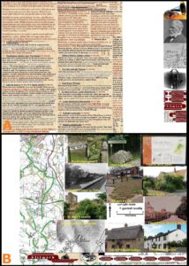
Figure 15. Summary distribution of the layout elements for the ‘Flitwick & Silsoe’ guide-publication. These have been prepared by blocking together identical layout (text, white space and illustrations) elements to better visually show their relative proportions; the front (15A) and (15B) back pages are markedly different in their amount of text, white space and illustrations. 15A. has clearly too much text, and 15B. lacks any text but this is because the full-page annotated route-map approach unique to this geotrail’s guide-publication.
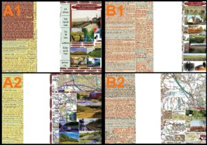
Figure 16. Summary distribution of the layout elements for two of the new geotrail guide-publications. These have been prepared by blocking together identical layout elements (text, white space and illustrations) to better visually show their relative proportions. A) For ‘Luton to Stanbridgeford’ shows the slightly varying proportions, and the contribution of white space to reducing apparent page clutter, between the front (A1) and back (A2) pages. B) For ‘Bedford to Bromham’ shows the slightly varying proportions between the front (B1) showing the extra amount of text needed for the route description and back (B2) with the route-maps pages.
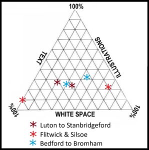
Figure 17. Ternary diagram of the layout elements for three of the new geotrail guide-publications. This indicates that the layouts of two of the guide-publications, for the ‘Luton to Stanbridgeford’ and ‘Bedford to Bromham’ geotrails, may be close to the ideal; however, the ‘Flitwick & Silsoe’ guide-publication shows the outlying nature of elements of layout.
Few users seem to have actually cycled the routes in their entirety, with most driving to specific localities and then walking parts of the routes; something that planned promotion through local cycling and tourist information outlets will now address, initially through printed versions . The attractiveness of some, such as that for the ‘Luton to Stanbridgeford’ geotrail (with its vivid color scheme), is greater than others. Views are mixed on the life in the Edwardian period information; that on the railways is generally of much interest. One interesting and useful comment concerned the amount of colored inks needed to print the ‘Tring to Berkhamsted’ and ‘Leighton Buzzard to Stewkley’ leaflets! Subsequently, versions have been prepared without the LMSR background ‘custard’ color for users, and available on request, wanting a cheaply printed version. It is not yet possible to determine the best approach in presenting the five guide-publications but that should become clearer over time with increased feedback and a possible user-group workshop.
Conclusions
With the current resurgence in cycling in the UK (Havaei-Ahary 2021) the record of historic GA excursions up to 1920 could demonstrably underpin modern cyclists’ and pedestrian geotrails; their great number was recorded in an Edwardian period review that noted: “During its 50 years' life the Association has held no less than 524 excursions and 241 visits to Museums...” (Watts 1909 p. 131). Part or all of the original excursion routes, as for the five geotrails, and their extant (and any replacement) localities can be incorporated within modern geotrails. Further, historical and human interest material, together with some comparative account of bicycle and cycling technology, should be included to better engage with the essentially casual recreational (and geotourist) cyclist users; it would provide users with some appreciation of, and hopefully engender empathy for, protecting historic structures and landscapes, together with geoconservation.
As an approach to sustainable, if somewhat niche, geotourism provision (Hose 2005) there is demonstrably much potential for others to re-examine the GA’s historic excursions as the basis for geo-historical interpretive provision for cyclist, pedestrian and even motor routes. However, 1920 would have to be the cut-off date for cyclists’ geotrails because by then the GA had almost wholly embraced motorized excursions, often with distances too long to walk between visited geosites and made little use of railways. Further, the length of the original pedestrian and horse-drawn vehicle routes at around 15 miles (24.1 km) maximum make them ideal for conversion into modern cyclists’ geotrails. Such geotrails combining legacy and modern geological information and interpretation, are best presented through the personalities and experiences of past geologists and field excursionists; that is, interpretive provision to audiences wider than the traditional geological community for whom the original GA excursions were intended. This approach aligns with the four interrelated aspects of modern geotourism, the 4Gs of geodiversity, geoconservation, geohistory, and geo-interpretation (Davies & Hose 2016, p. 310). That geodiversity (Hose 2016, pp. 3-4) should include material and localities beyond the purely geological and geomorphological, such as buildings and museum displays – recognizing its cultural significance – but space constraints, and noting the wide availability of wildlife site-publications, necessarily sidelines the inclusion of much about plants and animals. It is hoped that the publication of the five new geotrails for use by outdoor recreationalists, with just a passing interest in today’s landscapes and townscapes and how they have developed, has reinforced a message originally published in 1950 about two of geology’s purposes: “one material, the other spiritual; it provides the raw materials of this kind of civilization, and it satisfies certain spiritual aspirations in its followers. Many more ordinary people could take advantage of its spiritual gifts” (Read 1970, p. 420).
Acknowledgments
The research facilities afforded by the School of Earth Sciences, University of Bristol together with the encouragement of Professor Michael J Benton are gratefully acknowledged. Access to the unpublished archives of the Geologists’ Association and bound volumes of the Monthly Circular of the Geologists’ Association were particularly aided by Sarah Stafford at the Association’s Burlington House office. I am particularly grateful to Dr. Ian Stimpson for uploading the geotrail guide-publications to the GCUK website and for preparing an accompanying location map for them. GCUK’s, non-financial, support for this geotrail project is acknowledged. The constructive comments of two referees who ensured that some matters were not overlooked is gratefully recognized. Finally, the debt to those long-deceased members of the Geologists’ Association who prepared and wrote up their excursions must be acknowledged because their legacy thankfully lives on.
Conflict of Interest
The author declares that he has no conflicts of interest with this journal or its Editorial Board. No financial support was received from any individual or organization for this self-funded geotrail project.