Introduction
Geosites are classified by some authors (Palacio Prieto 2013; Brilha 2015) as sites of geological interest and are associated with their point in geological time. They are important in explaining geological processes and the evolution of a given area, region or the planet. Their geological age is more relevant than the area they cover (Palacio Prieto 2013).
In Europe, the first geoconservation efforts date back to the nineteenth century (Gonggrijp 2000; Ferreira Gamboa 2017), although some authors suggested that these efforts began even before that (Gray 2004; Gray 2013). During the second half of the 20th century, many European countries began to work on these issues. The first lists of geological sites worthy of conservation were made in the UK in the 1950s, and the intensive review occurred after 1977 as part of a national Earth Science Conservation Strategy (NCC 1990). The GEOTOP program in Sweden (Johannson et al. 1997) is another example. In 1978, Spain began to work on the inventory of geosites and 30 years later, activities related to geosites and geoconservation increased worldwide (García-Cortés et al. 2019). From a geoheritage and geoconservation perspective, Australia has played a crucial role in the establishment of the geodiversity concept (Crisp et al. 2020). According to Dingwall (2000), in December of 2007 there were 114 natural properties and 20 natural/cultural properties inscribed on the World Heritage List, and at least 50 (in 26 countries) were regarded as sites with primary geological significance (IUCN 1999). In 1996, the proposal to create geoparks began to grow as a serious alternative to resource exploitation (Brocx & Semeniuk 2007).
Although in Latin America geoconservation is just beginning, some countries like Chile, Colombia, Argentina, Costa Rica, Venezuela, Uruguay, Peru and México are working on geoconservation and geoparks (Palacio Prieto 2013; Medina 2012). In 2017, the Latin America and Caribbean Network of Geoparks (GeoLAC in Spanish) was created to facilitate and increase the exchange of experiences on geoconservation (Poch Serra 2019). In Brazil, the significant growth of the national science and technology budget between 2006 and 2014 helped to increase efforts in geodiversity assessment and conservation of geosites (Garcia et al. 2019; Crisp et al. 2020).
In Cuba, the characterization of geosites began later. Gutiérrez Domech et al. (2007) proposed a methodology for the characterization and protection of Cuban geological heritage and after that, some authors have suggested many geosites in Cuba (Pantaleón Vento et al. 2011; Gutiérrez Domech et al. 2011, Pereira Romero et al. 2017). In 2020, a new ordinance (11/2020) on the Cuban geological heritage that established guidelines on geosites, their conservation and strategies to create geoparks was published. The methodology proposed by Gutiérrez Domech et al. (2007) was officially approved for the proposal of new geosites.
Some stromatolite sites have been designated as geosites for conservation purposes around the world. Beraaouz et al. (2019) proposed the Stromatolite Geosite of Amane-n’Tourhart because these primitive micro-organisms tell an important story about the history of life on Earth. Albani et al. (2020) found some new geosites for geoconservation and geotourism use in the region of Bahia (Brazil), and two of them were stromatolite sites (Vajado and Gameleira) with national relevance.
In Cuba, some15 geosites from the Sabana-Camagüey Archipelago were proposed in four provinces. In Cayo Coco, only two had been proposed (Gutiérrez Domech et al. 2012, but they have not been approved by the Government yet. There is no evidence of proposed or approved geosites relating to recent stromatolites in Cuba, so our proposal here would be the first in the national inventory. The aim of our study is to propose two new stromatolite geosites for geoconservation on the Sabana-Camagüey Archipelago.
Characteristics of the Study Zone
The Sabana-Camagüey Archipelago stretches more than 460 km from the Hicacos Peninsula to the Bay of Nuevitas. This archipelago is formed by many small islands (around 2517), with large areas of mangroves and coral reefs. The largest islands of the Sabana-Camagüey Archipelago are Cayo Romano (777 km2), Cayo Coco (370 km2) and Cayo Sabinal (335 km2) (Fig. 1). There are two well defined seasons in the area: dry, from November to April, and wet, from May to October (Fig. 2). The soil of the keys is thin and mainly carbonate (rendzina), with large sandy beaches without river discharges.
Cayo Sabinal is located on the eastern portion of the archipelago (Fig. 1). The relief of the key is flat (Hernández Santana & Díaz Díaz 1989). There are many swamps particularly in the south, with predominance of mangroves (Rizophora mangle and Conocarpus erectus) over halophyte vegetation (Batis maritima and Salicornia subterminalis). The annual evaporation (2000–2200 mm) exceeds the annual precipitation (1200–1400 mm) (Fig. 2). Large beaches (more than 30 km) stretch along the coast and fringing reefs border the reef lagoon. A 30 km road runs from east to west in Cayo Sabinal. There are five more roads across the key that stretch from the southern to the northern coast. The principal economic activities are beekeeping, occasional fishing and day trips for tourists to one of the beaches distant from the lagoons. Two small scientific and conservation facilities (two field research stations and a forest watching station) have been built in Cayo Sabinal for science-based management purposes.
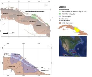
Figure 1. Maps showing location of the Sabana-Camagüey Archipelago, Cuba (A) and the Cayo Coco (Ciego de Ávila Province) and Cayo Sabinal (Camagüey Province) lagoons (B).
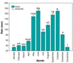
Figure 2. Historical mean monthly rainfall (in mm) in Cayo Coco through 1961–2020. Minor letters denoted significant differences among months.
Los Caimanes (0.32 km2) is a shallow lagoon (< 2.0 m) located in Cayo Sabinal (21.752N; 77.350W). Of the two lagoons, it is the one with less anthropogenic activities. There is a road on the southern side that limits the only water exchange with the adjacent shallow coast. (Fig. 3). Due to this restriction, Los Caimanes is a hypersaline lagoon. Microbialites (stromatolites), one of the most interesting bacteria formations of the natural world, can be found at this site (Valdespino-Castillo et al. 2018). Valdespino-Castillo et al. (2018) determined the mineralogy of stromatolites at Los Caimanes Lagoon as comprising five minerals: calcite (36 %); gypsum (27 %), hexahidrite (25 %), aragonite (10 %) and quartz (2 %). Gonzaléz-De Zayas et al. (2020) documented high salinity (more than 100 PSU), high concentrations of TN (193.9 µM) and TP (2.7 µM), and low levels of some heavy metals at the site.
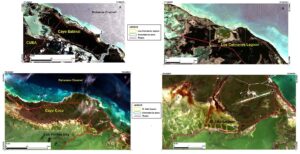
Figure 3. Aerial images of Cayo Sabinal (A), Los Caimanes Lagoon (B), Cayo Coco (C), and El Jato Lagoon (D).
Located in the Gran Humedal del Norte de Ciego de Ávila (Ramsar site), Cayo Coco (370 km²) is the second-largest island in the Sabana-Camaguey Archipelago (Fig. 1) and has become an important tourist destination (Jardines del Rey). Tourism development began in the 1990s and has continued since. More than 15,000 rooms in 15 hotels have been built. The coastal zone of Cayo Coco is characterized by sandy beaches, seagrass beds and coral reefs. South of Cayo Coco, there are large mangrove areas (Rhizophora mangle and Avicennia germinans), saltmarshes and halophytic vegetation (e.g. Salicornia perennis and Batis maritima). In 1988, Cayo Coco was connected to the mainland by a causeway across Bahia de los Perros (Los Perros Bay), a hypersaline water body that borders the south-eastern coast of the key. Isolation favored the formation of a shallow “lagoon” network (22.428N; 78.355W) (Fig. 3). These lagoons, including El Jato Lagoon, are highly dependent of climatic conditions. During most of the dry season (November–April), the lagoons show a very low water level (around 0.75 m) including desiccation of some areas (Bouton et al. 2015). During the wet season (May–October), the lagoons are inundated by rain and runoff waters, which transport sediments and organic matter from the nearby forests and mangroves. Water exchange between the lagoons and Los Perros Bay is limited to some small artificial culverts that connect the lagoons and the area west of the road to Cayo Coco. In January 2013, salinity was 67–75‰, while in July 2014 it was 54–63‰ (Bouton et al. 2015).
The lagoon network, including El Jato Lagoon, sits on a Pleistocene substrate composed of highly pedogenized limestone. Limestone initially consisted of ooid and bioclastic wackestones and grainstones deposited from the shoreface to the lagoonal environment. Reworking of the deposits by aeolian processes forming coastal dunes explains the peculiar morphography of the present lagoon network. Paleodunes (topographic highs or fossil eolian sand dunes) separate the lagoons that formed in the depressions between such highs. Strong pedogenesis, indicated by the presence of rhizocretions, micritization and grainification processes, affected these deposits before lithification was complete, suggesting early emersion periods (Bouton et al. 2015).
Methodology for Evaluation of Geosites
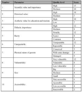
Both geosites were evaluated following the criteria proposed by Gutiérrez Domech et al. (2007), which consists of a qualitative and quantitative evaluation of each geosite, taking into account the quality of ten parameters and a score of 100 points (Table 1). The score given to each parameter are proportional to their importance:
Scientific value and importance: Scientific aspects, such as evidence of macro and/or microfossils, rocks of a particular geological age or development of any unique landscape. Also, this parameter evaluates the value of the site in showing important geological elements or process.
Historical value: This relates to the importance of site as a key point in the development of geosciences.
Aesthetic value for education and tourism: This includes spectacular geological structures, which are appreciated by visitors, whether expert or not.
Didactic importance: Aspects related to education or promotion of geosciences.
Rarity: The representativeness of site in context of the area where is located.
Unrepeatable: This documents the uniqueness of the site, in the context of other similar sites and whether the features would be unrecoverable if it disappeared.
Physical status of geosite: This documents the presence of sewage and garbage and if the site is used for another economic or social activity.
Vulnerability: The risk of damage to the site by any activity, natural or human.
Size: The size of site, scoring high points if the size is more than 1 ha and low if it is 0.01 ha.
Accessibility: Ease of access to the site using normal means of transport, taking into account the presence of highways or roads.
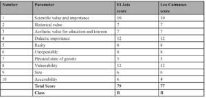
Table 1. Parameters, quality level and proposed score in the geosite scoring methodology proposed by Gutiérrez Domech et al. (2007).
The first six parameters represent the scientific relevance of site and the reasons why it should be considered as geological heritage. The last four parameters are related to protecting the site and important geoconservation actions. The final score represents the grade of relevance for better protection, and its national or local significance. The classification scale proposed by Gutiérrez Domech et al. (2007) is:
- Class A: Final score 85–100 points.
- Class B: Final score 70–84 points.
- Class C: Final score 50–69 points.
Results and Discussion
The qualitative and quantitative assessment of both lagoons, following the methodology proposed by Gutiérrez Domech et al. (2007), showed that they (Table 2) could be defined as Class B, with a final score of 77 points for Los Caimanes Lagoon and 79 points for El Jato Lagoon. Only Vulnerability and Didactic importance were given a score of 100 points because the lagoons are currently, and will be in future, under threats of climate change (sea level rise and more frequent and intense hurricanes) and tourism development in Cayo Sabinal and Cayo Coco. The principal value of both geosites is their scientific value. However, this parameter was evaluated as medium to match the description of the methodology used. Nonetheless, the identification and proposal of great scientific relevance for these geosites will help promote sustainable actions and the dissemination of geoscience (García-Cortés et al. 2019).
The geological historical value for both lagoons was evaluated as medium, following the methodology. However, we believe that this value could have been evaluated as high, due to the presence of microbiolites and their relation to the geochemical history of the Earth (Reid et al. 2000; Dupraz et al. 2009).
Rarity was regarded as medium for both lagoons considering that this kind of geosite had not been described in Cuba before (Bouton et al. 2015; Valdespino-Castillo et al. 2018; Bouton et al. 2020) and our proposal (if approved by the corresponding authority) will be the first related to recent stromatolites in Cuba.
Both lagoons are protected. The area where the microbiolites are found is small, and the principal difference between them is accessibility. While El Jato Lagoon is very accessible, being near two roads, Los Caimanes Lagoon is less accessible, having only ground access, which is restricted and controlled by government authorities (Fig. 3).
We rated the aesthetic value for education and tourism as low because these stromatolites are not an attraction for visitors and tourists. Our conclusion is based on the physical characteristics of the stromatolites at both lagoons: they are submerged in turbid waters in Los Caimanes lagoon, and they do not have a vertical development as in the stromatolites from Shark Bay, Australia (Pagès et al. 2014) or Balacar Lagoon, Mexico (Figs. 4, 5). However, both lagoons could be used for scientific tourism due to their unique characteristics in Cuba and the Caribbean’s lagoon systems (Dupraz et al. 2013; Bouton et al. 2015: Valdespino-Castillo et al. 2018; Bouton et al. 2020).
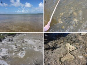
Figure 4. The stromatolites of El Jaton Lagoon. A) Partial view of El Jato Lagoon with submerged stromatolites. B) Submerged stromatolites. C) Partial view of desiccated zones in El Jato Lagoon with exposed stromatolites. D) Exposed stromatolites. (Pictures are courtesy of Dr. Emmanuelle Vennin).
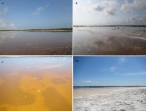
Figure 5. The stromatolites of Los Caimanes Lagoon. A) Partial view of Los Caimanes Lagoon with submerged stromatolites. B) Partially submerged stromatolites. C) Submerged stromatolites in turbid waters. D) Exposed stromatolites.
Summing up, we conclude that parameters 1, 3, 4 and 5 from Table 2 are the most important to understand the scientific value/potential of these geosites. Their medium to high scores can help to establish a geoconservation status they lack today.
Table 2. Score of both sites for each parameter, total score and class type taken from the methodology proposed by Gutiérrez Domech et al. (2007).
As a comparison, Silva et al. (2018) proposed Lagoa Salgada in Brazil as a “Geosite of International Relevance” based on a high score using the methodology of Brilha (2015) and García-Cortés & Carcavilla Urqui (2009). Lagoa Salgada is a very important scientific place because it has the only recent occurrence of stromatolites in Brazil, besides microbial mats, thrombolites and oncolites (Srivastava 2002; Silva e Silva et al. 2007; Iespa et al. 2012). Unlike our proposed geosites, this lagoon has been thoroughly studied (nine papers in Brazilian journals, four doctoral theses, 11 master’s dissertations and two chapters in books).
Conclusion
Although both the Cayo Coco and Cayo Sabinal sites are in sites of actual and potential tourism development areas respectively, they are not attractive for geotourism, because the stromatolites are hard to interpret by non-experts, and generally the areas are not rich in other geological features. However, they are of scientific and academic tourist interest, particularly for researchers and students with a focus on geology, ecology, biology and paleoclimatology. From this point of view, protection and management of both sites could be enhanced by the local authorities in charge of the protected areas where they are located, in the case of el Jato lagoon at the Ramsar site Gran Humedal del Norte de Ciego de Ávila.
Brilha (2018) has shown the benefits of a good conservation status in encouraging further study through national and international publications, which further enhances understanding of their importance. Our ranking of both sites as Class B, reflecting their regional and local importance, we hope will encourage the Cuban authorities to evaluate our proposal. After approval by the Cuban Government for some management and protection category to both geosites, local and environmental authorities could seek national and international funds and partners to conduct further studies of these microbial communities. Approval of our proposed geosites and others around Cuba will place our country at the level of other Latin American nations in protection of our geological heritage.
Acknowledgments
We thank the National Program of Cuba “Sustainable use of Biological Diversity in Cuba” for financing the project “La biodiversidad de las lagunas costeras del Archipiélago Sabana – Camagüey en el contexto del cambio climático global. Pautas para su manejo y conservación” with code P211LH005-013. We thank Vicente O. Rodríguez for English revision. Thanks to IdeaWild org for laptop and digital camera support. We are very grateful to reviewers for their great comments and recommendations. Thanks to Dr. Emmanuelle Vennin for pictures from El Jato Lagoon.
Conflict of Interest
The authors declare that they have no competing interest. The view expressed in this short paper does not necessarily reflect those of their institutions.