Introduction
The growing international recognition of geoparks and the emergence of active or sporting tourism, where the motivation of travel is to engage with sports or free time activity mainly outdoors, have been simultaneous processes. One of the most common elements of geosite-based regional development is geotourism and related services (Dowling & Newsome eds. 2006; Farsani et al. 2011; Migoń & Pijet-Migoń 2017; Štrba et al. 2020). In this context, hiking can be located at an intersection between active and other close-to-nature tourism modes (e.g. eco-, geotourism, Jaafar et al. 2014; Penić et al. 2016).
Geohiking is a short term for geology-themed hiking, where field-based activities are used to expose geodiversity to the public. These activities are becoming more important worldwide and special thematic trails with features of geological interest (e.g. German Volcano Route, Koziol & Röhl 2002) can have a supporting role in public dissemination. Organized geohiking can provide an opportunity to raise awareness of the regional geodiversity (e.g. through geoparks), thereby increasing its popularity. The educational role of hiking is emphasized by study trails which provide geology-based information about the geoheritage values seen along the hiking trail and using various means (Massachusetts Department of Conservation and Recreation 2012; Geert 2019).
Organized hiking tours are widespread in several European countries (Rodrigues et al. 2010; Dreyer & Menzel 2016; Puczkó et al. 2016; Gómez-Martín 2019). Endurance hiking is a specific type of hiking at the intersection of sport, active and nature-based tourism. In these events, participants complete a defined hiking route in a given time (Sütő et al. 2011). In Hungary, it is a popular form of organized mountain tourism, attended by a total of 120–150,000 people per year (TTT 2016). An important question is how we can make geoheritage values visible to the target audience (Tormey 2019) and how we can combine the essentially sporting and active tourism aspects with scientific dissemination. The combination of hiking and geo-education is a very interesting segment in geotourism. Some studies have been written on the programs, role, and effectiveness of school and higher education fieldworks (Boyle et al. 2007; Oost et al. 2011; Remmen & Frøyland 2014) but there has been no detailed investigation about the connections of the geotour and indirect field trip education.
The Hungarian Geotope Day was established in 2009 to promote geoheritage through geo-guided tours and field educational games. Today the initiative has become a nationwide program, and educational guided tours took place at more than 20 locations in 2019. The Devil’s Tower Nature Trail in the Bükk Regional Geopark (BRG) was introduced at the established site (Cserépfalu, Bükk, Figs. 1, 2). Its organization is based on the model of Geotope Day in Germany (Pustal 2003; Novák et al. 2012). The term geotope is included in the name of the event, which indicates a demonstration area is rich in geosites. The Devil's Tower Nature Trail links several geosites in the southern part of the mountains. The 12-km-long educational tour uses five geosites as field demonstration points. The event is co-organized with the Less Nándor Memorial Hiking Trail (Less Nándor MHT; in Hungarian, Less Nándor Emléktúra) with longer distances (20, 38, 66 km) which has been operating for 12 years. There was a significant overlap in the target audience of the endurance hiking and hiking geotourists.
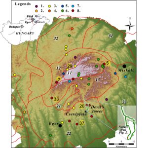
Figure 1. Location of the geoheritage values of the Bükk Region Geopark [base map: https://www.usgs.gov/centers/eros/science/usgs-eros-archive-digital-elevation-shuttle-radar-topography-mission-srtm-non?qt-science_center_objects=0#qt-science_center_objects]. Legend: Thematic geosite classification: 1. Historic earthwork 2. Volcanic Phenomena 3. Sediment 4. Mass Movement 5. Fluvial form 6. Karst 7. Spring 8. Polygenetic form, Lands of the Bükk Mts. 11. Bükk Plateau, 12. North Bükk, 13. South Bükk, 21. Tárkány Basin, 22. Bükk Foothills of Eger, 23. Bükkalja Foothills of Miskolc, 31. Tardona hills, 32. Uppony Mountains
Main geosites of the BRG: 5. Anna Cave, 7. Bél Stone; 20. Hór valley & Subalyuk Cave, 29. Caves of the prehistoric man (Istállós Stone) 33. Szarvaskő Castle Hill, 37. Beehive stone (Szomolya)
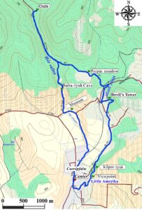
Figure 2. Map of the Geotope trail [base map: Map created with mkgmp-rsvn]. Legend: Little America, Kőpor-lyuk: Cave dwellings carved into rhyolite tuff, volcano explosion demonstration, rock and mineral recognition, pumice floating. Millennium Viewpoint: recognition of characteristic landscapes and reliefs. Devil's Tower beehive stone: geo positioning tasks, drawn time-series modeling of the beehive stone formation process. Perpác meadow: geobotany: Getting to know the herbs widespread on the limestone and their geoecological connections. Subalyuk Cave: Picture puzzle of the fossils’ nominees: Congeria mussels (Balaton goat's claw), cave bear, woolly mammoth, as well as about the Subalyuk Cave itself, its inhabitant, the Neanderthal prehistoric man and the stones used by him. In the center: Puzzle and possibility to vote for Mineral and Fossil of the Year. During the tour: possibility to collect pumice, Triassic limestone and calcite.
The number of hiking geotourist participants reached 1000 in 2019, but there was no detailed investigation about their motivation and categorization. In addition, organizers also wanted feedback from visitors about geosites, field activities and educational games. Filling the gap, a questionnaire was made, and the survey was conducted between 2016 and 2019.
In this study, we explore how and to what extent an active hiking community can be involved in the promotion of earth sciences, using the Geotope Day of the Less Nándor MHT. We had a complete, temporal cross-section regarding the evolution of scientific dissemination from the introduction of the Hungarian Geotope Day to interactive geo-educational attractions.
In the last four events, we conducted a questionnaire survey among the visitors of Geotope Day tour to find out what they think about the programs and whether our efforts and developments are moving in the right direction. The results are expected to characterize the hiking geotourist community, understand their motivations, expectations and define target groups and limitation of the number of participants for field-based educational games.
Geography of the Bükk Region Geopark and Devil’s Tower Nature Trail
The Bükk Mountains wedges into the Miocene volcanic chain of the North Hungarian Range and has the highest average elevation in Hungary (of the 100 highest peaks in Hungary, 60 are in the Bükk Mountains). The relief of the geopark area including the studied educational geotrail, reveals the nearly 500 Ma old, very complex geological history (Mesozoic-Neogene sedimentation, Miocene volcanism) which is the main cause for the high regional geological diversity (Haas 2013; Mezősi 2017). The oldest, Palaeozoic sedimentary formations crop out in the northern part of the Bükk and in the Uppony Mountains (Baráz ed. 2002). The characteristic of the Bükk Plateau is built up by thick Middle–Upper Triassic carbonates and shales, but Jurassic magmatic rocks (basalt) also occur (Szarvaskő, site 33, Fig. 1; Kiss et al. 2018). The southern foreland (Bükkalja–Bükk foothills) is mostly covered by Palaeogene-Neogene shallow marine sediments and Miocene ignimbrite (Lukács et al. 2005).
The mountains have a long history of research beginning in the 18th century. One of the most complete books about the Bükk Mountains was written by experts researching the area, in collaboration with the Bükk National Park (Baráz ed. 2002; Pelikán ed. 2005). Significant geosites, for example, gorges, beehives, travertine mounds, and karsts, were included in the Landscapes and Landforms of Hungary (Baráz 2015; Benkhard 2015; Demeter & Szalai 2015; Sütő et al. 2015).
There are two UNESCO Global Geopark members in Hungary (Novohrad-Nógrád Geopark awarded in 2010, Bakony-Balaton Geopark awarded in 2012). The third, the Bükk Region Geopark (BRG) (https://kaptarkovek.bnpi.hu/hu/a-bukk-videk-geopark/) covers the whole Bükk Mountains (almost 3% of the surface area of Hungary). It was established in 2017 under the coordination of the Bükk National Park, and the organization will apply for the title of UNESCO Global Geopark in the future.
The geodiversity of this geopark is shown by the fact that 40 major geosites with high scientific, aesthetic and educational values were selected from a total of 292 sites in the candidate inventory (Fig. 1). These geosites were divided into 13 groups according to their major geological and geomorphological processes. The most common values of the geopark are the various karst processes and forms, which makes up a quarter of the geosites. A fifth of geosites are polygenetic formations, so they consist of a combination of geology, geomorphology and often associated cultural values. Single geological outcrops appear in a similar proportion. Further, a significant number of values are represented by the various fluvial and frost fragmentation related forms. The cultural landscape elements show the role of humankind in the transformation of the landscape (e.g. mottes).
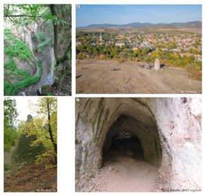
Figure 3. A) The gorge of the Mész Stream (by L. Sütő) B) View of Cserépfalu, the Millennium Viewpoint, the Bükk Foothills (Nyomó Hill) and the Southern Bükk (by Z. Jobbágy). C) The Devil’s Tower beehive (by Zs. Farkas) and D) the Subalyuk Cave (Less Nándor MHT archive).
The Devil's Tower Nature Trail was established in 2003 and is located on the border area of Bükkalja and the Southern Bükk (Martonné et al. 2003; Sütő et al. 2011) (Fig. 1). The first Hungarian Geotope Day (2009) was organized on its route. The 12-km-long track starts from Cserépfalu, linking various geological formations, geomorphological, geocultural objects emphasizing the different evolution of the karstic and volcanic landscape (Figs. 2, 3B). The erosion cones of the Devil's Tower beehive stone (Fig. 3C) and the gorge of the Mész Stream are formed in ignimbrite (Fig. 3A)
Similar erosional morphology is known from Cappadocia, Turkey (Baráz 2015). In addition to volcanological and geomorphological values, the volcanic landscape has special cultural-historical aspects (cellars, cave dwellings) (Dobos 2007). Moving northward, the Hór Valley geosites represent marine carbonates of the Mesozoic. Their frost-induced fragmentation and karstic landforms (Dobos 1997) are also important. A spectacular geoheritage value is Subalyuk Cave (Fig. 3D), which simultaneously shows the relict forms of karst underground streams, cave ruin, and it is internationally recognized as a prehistoric site (Bartucz et al. 1938, Mester & Patou-Mathis 2016). Based on our preliminary evaluation using a modified version of the GAM model (Sütő et al. 2020), the Hór Valley with the Subalyuk prehistoric cave can be considered to be of international significance (score 86%). The surroundings of the Devil's Tower are of national importance (with a score of 72%). The area is also part of the rhyolite tuff thematic trail in Bükk Foothills. The visitor center of prehistoric culture has been built in the opening of the valley and it also promotes the geo-values of the area.
The guided tour of Geotope Day
In Hungary, studies and geoconservation actions for the protection of geoheritage values have been carried out since the 19th century (Horváth & Lóczy 2015; Szepesi et al. 2018). The indirect history of the Hungarian Geotope Day has been associated with the Nándor Less MHT since 1997 (Novák et al. 2012), where we have been trying to promote scientific knowledge from the beginning. At that time, a simple booklet (https://nomegalljcsak.hu/geotop-nap) was made, describing the geodiversity of the area with the related botanical, landscape and cultural-historical aspects. However, we realized that the field identification of special geological features would have required skilled tour guidance. The next stage of development was the introduction of interactive games in the tour center, and film screenings about geology and the Bükk National Park.
Another development came with the organization of the Geotope Day guided tour along Devil’s Tower Nature Trail. In the first two years, geoheritage and geodiversity promotion was implemented as follows:
• We provided professional tour guidance at several times by geo-experts from the University of Debrecen and the Bükk National Park. The geoheritage values and geoconservation issues of the area were presented and explained along the geotrail. The number of people in a group ranged from 30 to 40, with 3–4 guided tours during one event.
• On the other hand, the educational program elements were transformed to outdoor activities, so the presentation was linked to direct observation of the geosites, also with experts as presenters. In the first few years, on average, 20–30% of participants took part in the geo-games.
• During the weekend of the Geotope Day, everyone was given free admission to the Subalyuk Museum visitor center.
• The Bükk National Park also provided nature conservation professionals and publications. Short presentations were given to those interested in the geoheritage values and nature conservation issues of Bükk Mountains.
Methods
The role of games in knowledge transfer and experience is being addressed more and more both in terms of tourism and environmental education (Xu et al. 2017; Ouariachi et al. 2020). During an organized event, a game-based method was developed for the efficient and empirical transfer of geoheritage and geoconservation knowledge. On the one hand, we provided a geo-tour guide for those who demanded continuous dissemination of knowledge during the tour. On the other hand, we held brief field demonstrations at each station, immediately showing the rock formations, the phenomena and the geomorphology included in the performance. After that, we let them play skill- or knowledge-building games in connection with geosites.
The effectiveness of the educational games and the opinions of the participants were measured with the questionnaire survey; this method is widely applied in tourism to examine visitors’ perceptions, characteristics, motivations and attitudes about development priorities (e.g. Telbisz et al. 2020). Questions about geo-values were formulated on the basis of environmental education literature (Lükő 2003).
The surveys related to geosites and geotourism were conducted between 2016 and 2019 at the Geotope Day (Cserépfalu, Bükk Mts.). The one-page, paper-based questionnaire of the Geotope Day includes 32, mostly closed-ended questions. The topics of the questions range from basic social data through the mode and motivation of tourism to some potential development-related questions. Responses were made using comparative ranking, semantic differential scale and multiple choice.
The first implementation was preceded by a pilot survey, which helped correct the questionnaire by answers and feedback to the organizers. Surveys were administered with the help of interviewers including geography students. The location of the survey was the tour center where it was completed by the participants after finishing the walk. We had 365 random fillers out of 2754 between 2016 and 2019. The basic population was considered to be the participants of Geotope Day. We aimed for simple random sampling every year, but due to the on-site estimation of the age of the hikers, or the effort of the hikers who arrived at the hiking center; this was not always fully realized. Professionalism was guaranteed by the interviewers who were well acquainted with the topic and the event.
The questionnaire was divided into two major parts – general visitor information and the event assessment. The first part included social characteristics (gender, age, qualification) and specific information about hiking habits (frequency, period, travel, hiking season, accommodation type). The event assessment included criteria affecting the Geotope Day visit (source of information, number of occasions of participating, visiting other Geotope Days) and visitors’ opinions and attitudes (organization of the event, effectiveness of information transfer, quality of programs, the motivation of participation). Comments on the development section (price sensitivity, development ideas) used the Likert scale (Likert 1932; Štrba 2019) ranging from 1 (absolutely unimportant) to 5 (very important).
The tool for data processing, analysis and visualization was MS Excel. Each of the forms was considered as an individual dataset, and evaluation was done by age groups, qualification, and information source of the results. The analysis of the results of the questionnaire was supplemented by background interviews with the organizers.
Results
The number of geotourists has increased significantly from the 5th event, and it reached 1,000 visitors in 2019 (Fig. 4A). The questionnaire was filled out by 13.7% of participants over the four years of the survey. Based on the geotour demography characteristics in the voluntary questionnaire fillings, the majority of participants came from primary schools, but this age group was under-represented in the respondents, while the youth age group was over-represented except in 2019, when those over the age of 65 were overrepresented (Fig. 4B). The interviewers tried to keep a balance between the younger adult and the older generation. The largest age group of the respondents was 15-25 years (44%) in the first year, which decreased to 6.2 % (2019).
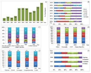
Figure 4. A) Number of visitors of the Geotope Day on the Devil’s Tower Nature Trail. B) Age distribution of respondents on the Geotope Day Legend: “Year” r: respondents, “Year” t: total participants. C) Qualification of respondents on Geotope Day. D) Number of participations of respondents on the Geotope Day. E) Source of information of respondents on the Geotope Day (multiple choice). F) Seasonal hiking habits of respondents on the Geotope Day.
The education level did not show much variability. The proportion of graduates and graduates in higher education was high (over 40%). The higher share of people with lower education is due to the age-group distribution (Fig. 4C). It has already been explored how best to communicate with people who are visiting protected areas, including how to provide visitor information (Tormey 2019). We asked a question about where they obtained information about Geotope Day. Based on the average of the four years, it can be seen that the most frequent source of information was the worldwide web. In this question, the respondents had more than one option to choose, so they signed friends and school with one-third at each (Fig. 4E). Regarding the restricted promotion possibilities, the least used source was newspapers.
The survey confirmed that there is strong, season-based segmentation in this hiking market. The respondents marked the main hiking period as primarily autumn (on average 35%), secondarily spring (on average 30%), thirdly summer (on average 22%) and lastly winter (on average 13%) (Fig. 4F). Examining the frequency of participation, approx. 40% of hikers were first participants, between 20–30% of them had been already on the tour twice, and more than 30% had arrived three times or more for Geotope Day (Fig. 4D).
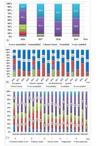
Figure 5. A) Opinion of respondents about the presentation of Geotope Day. B) Opinion of respondents about the main attractions of the Geotope Day. C) Opinion of respondents about the development of the Geotope Day Legend: 1. game point, 2. interactive program, 3. takeaway educational material, 4. easier-to-understand presentations, 5. information about the Bükk Region Geopark
Regarding the event assessment, nearly two-thirds of respondents were satisfied with the received scientific information of geosites (2016), which added up over 90% (Fig. 5A). Based on the experience and feedback, additional programs have been associated with interactive games in which all participants were involved. We encouraged everyone to complete the tasks. These geo-games take place at eight educational points now (Fig. 2). In our experience, active experiential knowledge transfer worked more effectively than a passive presentation. The greatest success of Geotope Day is the volcano eruption model shown every year (Fig. 5B). An excellent opportunity to expand the programs is the abovementioned visitor center of the Subalyuk Museum, where the life of prehistoric peoples is presented for the participants.
In the questionnaire, we also asked for suggestions for further improvements to the program (Fig. 5C). The figure shows that the distribution of responses is very diverse. Tour organization and programs are appropriate for the majority of respondents ("not important" answers). We expected more people to ask for the development of interactive programs and geo-games, which was confirmed by the responses. However, Geotope Day visitors are curious about the environment and are keen for more information.
Discussion
The existence of seasonal hiking habits (Fig. 4F) is partly because organizing school groups during the educational period is easier; on the other hand, summer is more of a period of family holidays; therefore, there are fewer participants in the organized hiking trails.
It is probably easy to explain the proportion of the trail information channels (Fig. 4E). Although it was still published in the local newspapers, tourism print press, and in the tour calendar at the beginning of the survey, in our experience, it did not significantly increase the awareness of the tour. Moreover, we had neither the financial resources nor the intention to advertise in a national newspaper. From 2018, the printed tour calendar has already been transferred to the internet, and the trail has not appeared in the print press. Some reports were usually made with the organizers in the months before the event on regional radio, but these apparently did not play an informational role.
The development of the geo-educational games of Geotope Day shows that the range of game and demonstration points has expanded compared to the earlier days (from four to eight field demonstration sites). Our experience shows there is a need for outdoor program. Primarily, families with small children participated in the games; larger school groups stopped less often, or just listened to the geo-guide talks. Interactive guided tours, on the other hand, were greatly enjoyed. Therefore, in some form, there is still a need for either lectures or, as the answers show, the sharing of additional information materials outside the tour booklet in the future (Fig. 5C). At the same time, several people highlighted a desire for smaller group size and the introduction of more explanatory points.
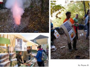
Figure 6. A) Volcano demonstration experiment in the Kőpor-lyuk (Less Nándor MHT archive). B) Explanation of volcanic demonstration by Szepesi J. (Less Nándor MHT archive) C) Mineral and Fossil of the Year puzzle at the center of Geotope Day (by D. Puyau)
Measuring satisfaction with geo-games can obtain a more detailed picture of the success related to the program elements. In the first year after changing the field geo-game presentation, there was apparently even greater resistance to mandatory puzzles and field education games. However, with the development of the website, the prior promotion of the program elements, the increase in the number of game opportunities in each location and the training of field experts, the situation has improved dramatically based on reviews. We expected the interactive programs and geo-games to be the most exciting. The satisfaction rate reached over 90%. Overall, the volcano show was considered as the most spectacular attraction (Figs. 6A, B), but the Mineral of the Year and the Fossil of the Year programs (Fig. 6C), and geosite-related field educational games were also outstandingly popular. It is clear from the results that children can be interested in nature, especially, if they have the opportunity to discover it in a tangible way. This corresponds to the literature about teaching natural sciences and geography, which considers the active participation of students as a priority in education (Lükő 2003; Homoki & Sütő 2015).
Given that large school groups arrive with teacher attendants on Geotope Day, this influences the evaluation of the answers, and the opinion of primary school students should be taken into account in future developments in proportion to their participation rate.
The level of qualification of adult participants also raises further questions for analysis. Although on the tour, we pay attention to people and families with lower income, there are more participants with higher education, hence a likely higher income. In our opinion, this is partly related to age distribution and partly - indirectly - related to discretionary income. Therefore, participants with higher education are overrepresented due to their motivation, income, and leisure time relative to real population ratios. A similar result was obtained with the distribution and motivation of the participants based on the research of leisure motivation (Manfredo et al. 1996), based on the survey of ecotourism (Eagles & Cascagnette 1995), and based on the survey of trekking (Balli & Canoglu 2017). This seems to contradict the myth of the cheapness of hiking, and raises the connection between environmental sensitivity and education, which play an important role in geotourism. The information channels in our 21st century digital communication-based world can be clearly traced. However, it is interesting to see the role of personal motivation and oral communication which have also been emphasized due to experience-based geotourism programs. These trends are also confirmed by Slovakian geotoursim segmentation (Štrba 2019).
Overall, those who come on geotours seem to find these forms of geo-education interesting and participate in solving tasks. This is definitely positive, as it allows a significant potential target audience to be addressed nationally about geoheritage values. In addition to interactive programs, many people seem to prefer to receive scientific information when it is associated with a field presentation. At the same time, considering environmental education, it seems an important result that more than 50% of the respondents would like to take home even more information about the geological values of the site. These results are in line with the findings of educational fieldworks that provide a foundation for longer-term motivation and lifelong learning (Boyle et al. 2007; Oost et al. 2011). That is the reason why we think our program is a good opportunity for a stronger involvement of the Bükk Region Geopark even in developing web-based materials.
Based on the answers of the questionnaire and decades of experience, some general suggestions can be made for organizing similar geo-programs:
• It is worth planning the tour at a place where there is a visitor center that can be involved in the promotion of earth science knowledge;
• It is important to emphasize the ecotourism-based approach in the attitude of the participants;
• The promotion of the Geotope Day program, such as field training, for example, among children and those who are interested could gain a “geotourism certification” can be a motivator for learning about geosites;
• The touristic messages should be delivered in a more targeted way during the marketing promotion of geotope attractions, paying attention to the target audience provided by schools, hiking organizations, families;
• It is useful to join national scientific educational programs (such as the Mineral of the Year, the Fossil of the Year);
• In the development of the programs, it is also useful to involve the less known geosites of the given area (water, atmosphere, soil, etc.).
Conclusions
In this study, we present the geosite network of a nature trail where the Hungarian Geotope Day was established in 2009. Meanwhile, the site has become part of the Bükk Region Geopark, which is currently preparing for UNESCO Global Geopark candidacy. This also emphasizes the importance of regional geodiversity. The evaluated results of the questionnaires characterize the hiking geotourist segments. Following this example, Geotope Day has become a series of nationally organized events in Hungary, so the outcomes represent an important source of information for planning these outdoor educational activities and developing motivation for geo-values.
Acknowledgment
Thanks to the staff of the Bükk National Park for the data and consultations: Éva Gasztonyi, Csaba Baráz, Sándor Holló and to Kinga Baranyi for the help in preparing the maps. László Sütő’s research was supported by EFOP-3.6.1-16-2016-00001‚ Complex improvement of research capacities and services at Eszterhazy Karoly University. János Szepesi and Zsuzsanna Ésik’s work was supported by the European Union and the State of Hungary, co-financed by the European Regional Development Fund in the project of GINOP-2.3.2-15-2016-00009 ‘ICER’.