Introduction
Natural disasters have continued throughout the history of the world (Soyluk and Harmankaya 2012; İlerisoy et al. 2022; Jung and Han 2022). Earthquakes are included in the class of natural disasters and are the result of seismic movements concentrated in many parts of the world (Rosselló et al. 2020). Earthquakes affect buildings in the first stage, and their subsequent effects can continue to generate wider social issues and environmental crises (İlerisoy and Gökgöz 2022). The Düzce earthquake in 1999, the Bam earthquake in 2003, the Wenchuan earthquake in 2008, the Haiti earthquake in 2010, the Van earthquake in 2011, and the Japan earthquake in 2011 are natural disasters with high casualties (Nedjati et al. 2016; İlerisoy and Soyluk 2012). Post-earthquakedisasters also trigger an increase in casualties. Tsunamis occurred after the 2004 Indonesian earthquake, the 2011 Tohoku earthquake, and the 2018 Indonesian earthquake. After the 1995 Kobe and 2011 earthquakes in Japan, fires and explosions occurred due to the intensity and impact of the earthquake. Landslides following the Wenchuan earthquake in 2008, Lushan in 2013, Nepal in 2015, and the Nyingchi earthquake in 2017 also caused damage (Yang et al. 2015; Tang et al. 2016; Zhao et al. 2017; Zhao et al. 2019). Looking at volcanic eruptions after earthquakes, Pinatubo, the biggest eruption of the 20th century, occurred approximately 1 year after the 1990 Philippines earthquake. 47 days after the Hoei earthquake in 1707, Mount Fuji erupted (Nishimura 2017). After the 1975 Kalapana (Hawaii) earthquake, Kilauea volcano erupted in 1977 (González et al. 2021). Snow avalanche disasters can also be triggered by earthquakes (Puzrin et al. 2019). In 2023, after the7.8 and 7.6 magnitude earthquakes, which were described as the disaster of the century in Turkey, deep cracks were formed in some regions. Landslides have been triggered byearthquakes. The diversity of disasters triggered by earthquakes is an indication that academic studies in this field are multifaceted.
Loche et al. (2022) developed a slope unit-based multitemporal susceptibility model for the central region of the 2008 Wenchuan earthquake. With this model, the relationship between land surface temperature and landslides over time was evaluated. It was determined that the land surface temperature could explain the post-earthquake landslide. It was also found that there is no visible effect in the seismic scene where strong shaking is dominant. Lotfi et al. (2021) investigated whether a 28-storey multi-purpose high building could create a safe evacuation environment under post-earthquake fire. The operability of escape routes was measured using the Pyrosim program. Additionally, smoke generation and fire development on different floors were simulated. González et al. (2021) highlighted the relationship between tectonic earthquakes and volcanic eruptions. It has been shown that seismic waves and static stress parameters are effective in volcanic eruptions. After three earthquakes with a magnitude of more than 7.3 in Central America in 10 weeks in 2012, volcanic eruptions were observed within a few days, and these eruptions continued for months and years. It was emphasized that the increase in the number of volcanic eruptions for seven years after these three earthquakes following seismic events was remarkable. Davies et al. (2020) compared tsunamis following the Chile earthquake in 1960, the Sumatra earthquake in 2004, the Chile earthquake in 2010, the Tohoku earthquake in 2011, and the Chile earthquake in 2015, according to sixteen nearshore tide indicators in Australia.Each tsunami pattern was simulated for 60 hours, which isa pragmatic approach for developing tsunami simulations. Himoto (2019) performed a comparative analysis of 665 post-earthquake fires in Japan from 1995 to 2017 with the integration of survey data. The causes of fire, ignition, the spread of fire in urban areas, fire fighting activities, deaths and damage to fire safety equipment systems were investigated. Through the analysis, they observed that 70% of these fires occurred within one day after the main earthquakes occurred.
The Industry 4.0 revolution, developments in construction techniques, and artificial intelligence applications also improve post-earthquake disaster precautions (Takva et al. 2023a; Takva et al. 2023b; Takva and İlerisoy 2023a; Takva and İlerisoy 2023b). Based on information from the literature, methods developed to analyze post-earthquake disasters vary.There are many studies that investigate earthquake scenarios on reinforced concrete structure designs (İlerisoy and Tuna 2018; Harmankaya and Tuna 2011) and historical structures (Soyluk and İlerisoy 2013) from among the existing building stock. However,comparative academic studies on the methods used in post-earthquake disasters are limited. Here, we review post-earthquake disasters and explore the analytical methods. Although basic methods are used in the evaluation of post-earthquake disasters, methods specific to each disaster have also been developed. We aim to determine and classify the analytical methods developed for post-earthquake disasters and to show which methods can be used for academic studies in this field.
Methodology
Bibliometric analysis has increased in popularity recently (Donthu et al. 2021; Khan et al. 2021). Bibliometrics includes a variety of statistical analysis methods to evaluate scientific communication environments. The selected scientific literature can be assessed according to criteria such as author, citation, keyword, publication year, language, etc. These studies can reveal the current state of the literature, and analysis outputs can be organized according to publication by country, research areas, the total number of publications in publication platforms, analysis of authors, and the most cited publications and keywords (Merigó and Yang 2017; Gaviria-Marin et al. 2019), to generate an academic structureof links between articles (Ghaleb et al. 2022).
We used the bibliometric analysis tools WOSviewer and Biblioshiny. WOSviewer is an analysis software for scientific mapping and visualization (Hosseini et al. 2018). The bibliometrix R-package was used for data obtained from Biblioshiny, a web-based version of Bibliometrix (Aria and Cuccurullo 2017; Wang et al. 2021; Mougenot and Doussoulin 2022).
Academic studies summarized in the Web of Science database were reviewed for bibliometric analysis of post-earthquake disasters. The Web of Science Core Collection database was chosen because it has an interdisciplinary scope and includes many scientific publications (Skute 2019; Escamilla-Fajardo et al. 2020). For research in the database, ''post-earthquake fire'', ''post-earthquake tsunami'', ''post-earthquake flood'', ''post-earthquake avalanche'', ''post-earthquake landslide'', ''post-earthquake soil liquefaction'', and "post-earthquake volcanic eruption" keywordstrings were searched. As wider subjects, we used the terms "natural disaster" or "earthquake" (Fig. 1). Academic studies between the years 2000–2022 were examined according to the year of publication.As document types, we included articles, book chapters, proceedings papers, and reviews, but excluded data papers and early access documents. Academic studies published in English are within the scope of this study. According to these criteria, we retrieved 521 publications and 1586 author networks. Most of these 521 academic publications were published in journals.

Figure 1. Research method and flow chart.
Findings
Bibliometrics covers the application of mathematical and statistical analysis methods in evaluating scientific communication environments. Various findings related to scientific communication were reached by examining the characteristics of publications in bibliometric analyses. In bibliometric studies, which is one of the quantitative research methods, various determinations and inferences can be made by analyzing the publications following the determined characteristics (author, citation, keyword, publication year, language, etc.). With these determinations, the current state of the literaturewas revealed, and the environment was prepared for the elimination of problems in future studies by helping determine the development and problems. Publications by year of publication by country, research areas,the total number of publications in publication platforms, analysis of authors, and the most cited publications and keywords are given as sub-titles as analysis outputs. Most 521 academic publications obtained because of the analysis of the determined keywords were published in journals.
Analysis of Publications by Year
The distribution of studies by year shows years in which the subject was popular, and trends may include multiple papers in subsequent years. Until 2004, the number of publications was a maximum of two, and after that year the number of publications increased. The maximum number of publications up to 2009 was eight per year. Since 2010, the number of publications increased to double digits, rising continuously from 2008 to 2012, documenting increasing awareness about post-earthquake disasters. After 2010, there was a fluctuating trend in the number of publications, but an overall increase, from 18 in 2010 to 53 in 2020. The number of publications was 27 in 2018, 36 in 2019, and 49 in 2021 (Fig. 2). The annual growth rate was 19.88%. In 2022, a record was broken with 54 academic publications.
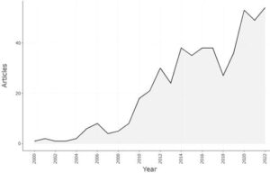
Figure 2. Annual scientific production.
.
The average number of citations per year has also increased towards the present. In 2002, the average number of citations per year reached a maximum of 2.8. This was followed by 2008 with 3.2 and 2011 with 4.5. As we approach today, fluctuations are seen in the number of citations, from 3.3 in 2015, 4.4 in 2020, and 3.5 in 2021.
Analysis of publications per country
By analyzing the publications according to country, it was determined which countries played an active role in the post-earthquake disasters. We identified publications from 55 countries. China had the highest number of publications, with 212 (Table 1), followed by the United States with 104 articles and Japan with 62 articles. The proof of the quality of scientific research depends on the number of citations. In terms of citations, China ranks first with 3444 citations, followed by the United States with 1158 and the Netherlands with 573 citations. Mexico has 2 academic publications, and the Philippines has 1 academic publication, but these two countries have zero citations. When the number of publications and citations is analyzed, it is seen that scientific studies are concentrated in China, the United States, and Japan. Although the number of publications in Japan was higher than the publications in the Netherlands, the number of citations fell behind: the number of publications in the Netherlands was 18, while the number of citations was 573. Similarly, although Switzerland was 27th in terms of the number of publications, it was 12th in the number of citations. Thailand was 32nd in terms of the number of publications (two), whereas it is 14th in the number of citations.
Research Area Analysis
Of the 521 academic publications researched, 421 were articles, 85 proceeding papers, 8 review articles, and 7 book chapters. The research areas with the most academic studies (Fig. 3) were engineering with 273 academic publications (10.9%), geology with 200 (8%), construction-building technology with 61 (2.4%), environmental science-ecology with 59 (2.3%), water resources with 52 (2%), materials science with 40 (1.6%), meteorology-atmospheric sciences with 38 (1.5%), remote sensing with 35 (1.4%), physical geography with 32 (1.2%), and computer sciences with 23 (0.9%).
The field of construction-building technology is seen as the closest science to architecture and constitutes the category that has the most impact on the discipline of architecture. Precautions should be taken against post-earthquake disasters by developing innovative design solutions in architecture. Effective approaches should be provided in the design process by increasing urban-scale settlement decisions and education awareness (İlerisoy et al. 2021).
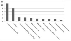
Figure 3. Percentage representation of research areas considering data from the Web of Science (WoS) database.
Analysis of the Total Number of Publications on Publishing Platforms
The 521 academic publications researched were published on 241 different publishing platforms. At the top of the list was Engineering Geology with 28 publications and 812 citations (Table 2). This journal publishes multidisciplinary articles dealing with issues involving ground motions and geological phenomena. This was followed by Landslides (18 publications; 635 citations) and Geomorphology (16 publications; 754 citations). The number of citations varied among journals with the same number of publications. As examples, and in terms of the number of citations, Natural Hazards and Earth System Sciences are among the journals with 10 academic publications, Bulletin of Engineering Geologyand the Environment among the journals with eight academic publications, Environmental Earth Sciences among the journals with six academic publications, and International Journal of Remote Sensing among the journals with five academic publications. It was observed that the citation rate was lower for book chapters, proceedings papers, and review articles compared to journals.
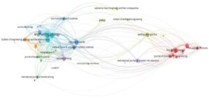
Figure 4. Links of journals by the total number of publications on publishing platforms.
There were 169 publishing platforms with one publication each and 72 publishing platforms with at least two publications (Fig. 4). Most articles in and around 2018 were published inLandslides, Geomorphology, Remote Sensing, Bulletin of Engineering Geology and the Environment, Sensors, International Journal of Disaster Risk Reduction, Fire Technology, Journal of Constructional Steel Research,Thin-walled Structures, and Journal of Structural Engineering. Articles in and around 2016 were mostly in Engineering Geology, Natural Hazards and Earth System Sciences, Geology, and Journal of Structural Fire Engineering. Articles in and around 2014 were mostly in Journal of Mountain Science, Earthquake Spectra, Fire Safety Journal, Natural Hazards, Journal of Hydrology, Journal of Asian Earth Sciences, and Bulletin of Earthquake Engineering. Articles in and around 2010 were mostly in International Journal of Remote Sensing, Journal of Fire Protection Engineering, and Journal of Ecology. Considering the citation networks of the journals, the Engineering Geology journal stood out.
Analysis of Authors and Most Cited Publications
Academic publications evaluated on post-earthquake disasters included 1586 authors. While the number of authors of academic publications with one author was 31, the number with more than one author was 1502. There were 1246 authors with one academic publication, 179 with two academic publications, 57 with three academic publications, 16 with four academic publications, 13 with five academic publications, and 22 with more than five academic publications. From 2011 to the present, it is seen that article trends and consistency have intensified.
Eighty-eight publications, including articles published in 2022, have not yet been cited. The number of academic publications cited once only was 43, 201 were cited at least ten times. The number of articles cited at least 30 times was 71, and the number of articles cited at least 50 times was 25. Eight articles hadover 100 citations, fourhad over 150 citations, and threehad over 250 citations (Table 4). Keefer (2002) was the most cited article, and Görüm et al. (2011) and Xu et al. (2014) also had high numbers of citations. The top 20 most cited articles were research articles, and the citation rate of review and proceedings paper publications is low.
Keyword Analysis
Keywords were selected in the form of commonly occurring word clusters throughout the sample of articles, and shown by colors (Fig. 5). Cluster 1 is the red zone with 20 common words, including the terms 2013 Lushan earthquake, aerial photographs, classification, coseismic landslides, damage detection, debris flows, disturbance, earthquake-induced landslides, earthquakes, erosion, geohazards, rock falls, satellite images, seismic slope stability, spatial analysis, spatial distribution, structural health monitoring, inventory, landslide inventory, and landslide dam. Cluster 2 is the green zone of 15 common words, including the terms community, conflagration, debris, emergency management, fire following earthquake, fire spread, GIS (Geographical Information Systems), ignition, modeling, physics-based, radiation, simulation, simulation system, and urban and urban planning. Cluster 3 is the blue region including 12 common words, namely composite building, displacement, failure mechanism, fire engineering, fire insulation, landslide susceptibility, logistic regression, multi-hazards, progressive collapse, susceptibility evaluation, and vulnerability. Cluster 4 is the yellow region of 10 common words, namely the 2011 Tohoku earthquake, co-seismic deformation, cross-sectional study, depression, disaster, earthquake and tsunami, Great East Japan earthquake, natural disasters, trauma, and tsunami are the words of this cluster. Cluster 5 is the purple region of nine common words, namely ArcGIS, bathymetry, Daguangbao landslide, Gorkha earthquake, hazard assessment, susceptibility mapping, Palu earthquake, material point method, and run-out analysis.
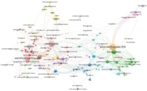
Figure 5. Comprehensive keyword map.
When the words in the titles of academic publications were examined, the most used word was "earthquake," used 187 times, followed by "post-earthquake" 177 times, "fire" 150 times, "landslide" 60 times, "Wenchuan" 51 times, "steel" 50 times, "landslides'' 46 times, ''China'' 38 times, ''seismic'' 36 times, ''resistance'' 31 times, and ''risk'' 28 times. Another application in keyword analysis is the three-field diagram method, which shows the connections between concepts according to their hierarchical order in research. Links between authors, countries, keywords, titles, abstracts, sources, references, and cited sources can also be created in triple combinations. Figure 6 shows the hierarchy between the keywords, along with the countries of the 18 most cited authors. In terms of country, China, the United States, and Australia were the countries with which authors interacted the most, followed by the Netherlands, Japan, Iran, the United Kingdom, Italy, and Canada. When we looked at the most popular keywords, Wenchuan earthquake, post-earthquake fire, landslides, and cyclic loading came to the fore. Slope stability was the least used keyword in the papers of the most cited authors.
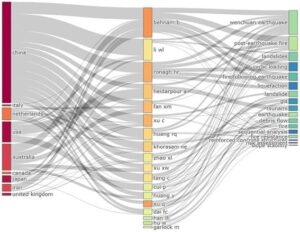
Figure 6. Relationship between countries, highly cited authors, and keywords
Results and Discussion
Research methods used in terms of post-earthquake disasters, environmental effects, and building performances are categorized in Table 4. These methods have turned into computer simulation programs with the developing technology and experimental methods are also being used today as in the past.
Academic studies on post-earthquake fires generally include studies on the geological structure. Steel-based studies have been tested in terms of static analysis and fire resistance. In post-earthquake tsunami studies, analyses were carried out with remote sensing methods including satellite and radar photographs. There are also articles using chemical data. In post-earthquake flood academic studies, methods similar to a post-earthquake tsunami are used, as well as tidal simulation studies, all summarized in Table 5.
In post-earthquake avalanche studies, it was determined that in addition to the methods used in other disasters, chemical analysis of the soil, and topographic and geographical mapping techniques were used. In post-earthquake soil liquefaction analyses, studies examining the structure of the soil were conducted.In post-earthquake volcanic eruption studies, methods in which seismic movements are predominant are used. While there are basic analysis methods for academic studies dealing with post-earthquake disasters, there are also studies in which two or more methods are combined or new techniques are developed. The classification of analysis methods is given in Table 6.
When the analysis methods of the 15 articles were examined, it was seen that the simulation method was dominant. Innovative mechanisms were developed in simulation methods supported by artificial intelligence applications. In addition, prediction methods were used against disasters that may occur in the future. In prediction and simulation methods, numerical calculations and inferences were made from the data. Apart from these studies in which qualitative and quantitative observations were applied, some studies analyze the area affected by the disaster. In these studies, in which situation analysis wasconducted, the extent of disasters post-earthquakes was seen on a large scale.
In Table 7, the scope of the analysis methods applied according to each disaster is explained. In post-earthquake fire studies, evaluations were made at the building scale.In post-earthquake tsunami and flood studies, the affected area was analyzed, including the extent of the flood and the soil structure of the region. In post-earthquake landslides, the situation of the affected area was reviewed with simulation and algorithm-based analysis. Post-earthquake soil liquefaction studies were carried out at the building and regional scale. In post-earthquake volcanic eruptions, regions with volcanic activity were examined. Considering the quality and number of academic studies, developed countries are dense, and a limited number of underdeveloped countries with active earthquake risk.
Conclusion
Earthquakes are natural disasters that cause the most damage from past to present, and clearly, precautions should be taken against these disasters. With the increasing intensity of earthquakes, the size of the disaster and destruction of the living environment increases. The expansion of existing settlements and the increase in new settlements create risks for the environment and people, making it difficult to respond to disasters. Disasters that occur after earthquakes increase the impact of the damage, leading to an increase in loss of life. For this reason, taking measures against post-earthquake disasters should be one of the most important priorities. Here, we investigated which analysis methods were used in academic studies of post-earthquake disasters, leading to inferences about how to raise awareness against disasters. Developing analysis methods will also affect future studies and make it easier to take precautions.
We focused on post-earthquake fire, tsunami, flood, landslide, and volcanic eruption disasters. Most discussed in academic studies are post-earthquake landslides, reflecting their common occurrence. In these studies, the analysis methods were generally similar and carried out on satellite photographs and geological maps. Next most discussed are post-earthquake fires which can cause a great deal of damage to buildings. In these studies, analysis methods developed against the structural elements were abundant, and simulation and experimental tests were carried out with programs for fire resistance of buildings. The area where the least work has been done is on post-earthquake avalanches, possibly because these are restricted to mountain areas far from cities. In future studies, it is predicted that the analysis methods used in post-earthquake disasters will improve and that objective and significant results can be obtained with the combinations of the classified methods.
Acknowledgments
The authors thank the Gazi University Academic Writing Application and Research Center for proofreading the article.
Conflict of interest
The authors declare that they have no conflict of interest in this work.
Tables list
Table 1. Number of publications per country.
Country | Number of articles | Country | Number of citations |
China | 212 | China | 3444 |
United States | 104 | United States | 1158 |
Japan | 62 | Netherlands | 573 |
United Kingdom | 37 | Japan | 466 |
Australia | 33 | Italy | 311 |
Iran | 31 | Australia | 272 |
New Zealand | 23 | United Kingdom | 219 |
Italy | 21 | New Zealand | 204 |
Netherlands | 18 | India | 161 |
Canada | 17 | Iran | 158 |
Taiwan | 14 | Canada | 140 |
India | 12 | Switzerland | 96 |
Chile | 10 | Belgium | 93 |
Turkey | 10 | Thailand | 88 |
Germany | 9 | Greece | 85 |
Indonesia | 8 | Pakistan | 75 |
Pakistan | 8 | Turkey | 51 |
Belgium | 7 | Chile | 42 |
France | 7 | Norway | 42 |
Nepal | 7 | Korea | 36 |
Table 2. Journals in which articles were published.
Academic journals | Number of articles | Number of citations |
ENGINEERING GEOLOGY | 28 | 812 |
LANDSLIDES | 18 | 635 |
GEOMORPHOLOGY | 16 | 754 |
FIRE SAFETY JOURNAL | 14 | 271 |
NATURAL HAZARDS | 13 | 452 |
JOURNAL OF CONSTRUCTIONAL STEEL RESEARCH | 12 | 124 |
EARTHQUAKE SPECTRA | 11 | 102 |
REMOTE SENSING | 11 | 82 |
JOURNAL OF MOUNTAIN SCIENCE | 10 | 149 |
NATURAL HAZARDS AND EARTH SYSTEM SCIENCES | 10 | 239 |
BULLETIN OF ENGINEERING GEOLOGY AND THE ENVIRONMENT | 8 | 103 |
INTERNATIONAL JOURNAL OF DISASTER RISK REDUCTION | 8 | 57 |
ISPRS INTERNATIONAL JOURNAL OF GEO-INFORMATION | 7 | 70 |
ENVIRONMENTAL EARTH SCIENCES | 6 | 129 |
JOURNAL OF STRUCTURAL FIRE ENGINEERING | 6 | 40 |
THIN-WALLED STRUCTURES | 6 | 61 |
FIRE TECHNOLOGY | 5 | 35 |
INTERNATIONAL JOURNAL OF REMOTE SENSING | 5 | 127 |
JOURNAL OF EARTHQUAKE ENGINEERING | 5 | 68 |
STRUCTURES | 5 | 20 |
Table 3. Analysis of the 20 most cited academic publications.
Reference | Title | Document type / method | Number of citations |
Keefer 2002 | Investigating landslides caused by earthquakes – A historical review | Article / literature review | 436 |
Görüm et al. 2011 | Distribution pattern of earthquake-induced landslides triggered by the 12 May 2008 Wenchuan earthquake | Article / optical high-resolution satellite images,landslide isopleths maps, and comparative analysis | 383 |
Xu et al. 2014 | Three (nearly) complete inventories of landslides triggered by the May 12, 2008 Wenchuan Mw 7.9 earthquake in China and their spatial distribution statistical analysis | Article / visual image interpretation, comparative and statistical analysis | 297 |
Cui et al. 2011 | The Wenchuan Earthquake (May 12, 2008), Sichuan Province, China, and resulting geohazards | Article / literature review | 243 |
Zhang et al. 2013 | Effects of near-fault seismic loadings on run-out of large-scale landslide: A case study | Article / a dynamic discrete numerical analysis method (DDA) | 124 |
Fan et al. 2018 | Coseismic landslides triggered by the 8th August 2017 Ms 7.0 Jiuzhaigou earthquake (Sichuan, China): factors controlling their spatial distribution and implications for the seismogenic blind fault identification | Article / high-resolution satellite images and unmanned aerial vehicle (UAV) photographs | 110 |
Xu et al. 2015 | Database and spatial distribution of landslides triggered by the Lushan, China Mw 6.6 earthquake of 20 April 2013 | Article / high-resolution aerial photographs and satellite images | 107 |
Fu et al. 2011 | Surface deformation related to the 2008 Wenchuan earthquake, and mountain building of the Longmen Shan, eastern Tibetan Plateau | Article / high-resolution remote sensing images and field surveys | 103 |
Xu et al. 2012 | Landslide Hazard Mapping Using GIS and weight of evidence model in Qingshui RiverWatershed of 2008 Wenchuan Earthquake Struck region | Article /aerial photographs, multi-source remote sensing imageries,topographic maps, and geological maps | 96 |
Wells et al. 2001 | Forest dynamics in Westland, New Zealand: the importance of large, infrequent earthquake-induced disturbance | Article / land surface and forest stand mapping | 94 |
Huang and Li 2014 | Post-earthquake landsliding and long-term impacts in the Wenchuan earthquake area, China | Article / multi-temporal remote sensing images | 93 |
Fan et al. 2012 | Analysis of landslide dams induced by the 2008 Wenchuan earthquake | Article / Mapping, image interpretation, and spatial distribution analysis | 89 |
Ragettli et al. 2016 | Heterogeneous glacier thinning patterns over the last 40 years in LangtangHimal, Nepal | Article / a digital elevation model (DEM) from satellite data and satellite imagery | 85 |
Van Daele et al. 2015 | A comparison of the sedimentary records of the 1960 and 2010 great Chilean earthquakes in 17 lakes: Implications for quantitative lacustrine palaeoseismology | Article / a combination of image analysis, magnetic susceptibility, and grain-size analysis | 84 |
Wang et al. 2015 | Controls on the fluvial evacuation of sediment from earthquake-triggered landslides | Article / the grain-size distribution and daily suspended sediment discharge analysis | 81 |
Della Corte et al. 2003 | Post-earthquake fire resistance of moment-resisting steel frames | Article / a simplified modelling of earthquake-induced structural damage and numerical analysis | 79 |
Tang et al. 2016 | Analysing post-earthquake landslide activity using multi-temporal landslide inventories near the epicentral area of the 2008 Wenchuan earthquake | Article / stereoscopic digital visual image interpretation | 73 |
Guo et al. 2016 | Intensity–duration threshold of rainfall-triggered debris flows in the Wenchuan Earthquake affected area, China | Article / field interviews with local witnesses, national, regional, and local media, reports from authorities, and professional papers and reports | 72 |
Khan et al. 2008 | Prevalence of HCV and HIV infections in 2005-Earthquake-affected areas of Pakistan | Article / blood samples (immunochromatography and enzyme-linked immunosorbent assay (ELISA)) | 72 |
Mousavi et al. 2008 | Review of post-earthquake fire hazard to building structures | Article / literature review | 67 |
Table 4. Methods used in post-earthquake disasters according to references.
Subject | References | Methods |
Post-earthquake fire | Della Corte et al. 2003; Memari et al. 2014; Pucinotti et al. 2011;Sinaie et al. 2014; Kamath et al. 2015; Imani et al. 2015; Ronagh and Behnam 2012; Ren and Xie 2004; Khorasani et al. 2016;Song et al. 2016; Xu et al. 2018 | Earthquake-induced structural damage and numerical analysis, finite element simulations, nonlinear time–history and thermal–mechanical analysis, non-linear numerical simulations, temperature and loading tests, GIS technology, computational fluid dynamics (CFD) models |
Post-earthquake tsunami | McHugh et al. 2016;Chini et al. 2008; Kaku et al. 2015;Liou et al. 2012; Kitamura and Kobayashi 2014;Liew and He 2008 | Short-lived radioisotopes, European Remote Sensing Satellite Synthetic Aperture Radar (ERS‐SAR) and Environment Satellite Advanced SAR (ENVISAT‐ASAR) data, earth observation satellites, remote sensing techniques, sediments core dataset |
Post-earthquake flood | Trisirisatayawong et al. 2011; Xu et al. 2010; Aydan et al. 2008; Ramakrishnan et al. 2020; Nobes et al. 2015 | GPS-corrected tide gauge data, multi-satellite altimetry, near-infrared radiometer, satellite images, pre- and post-earthquake aerial photographs, liquefaction assessments, aerial photogrammetry, tidal hydrodynamics simulation, electromagnetic (EM) and ground penetrating radar (GPR) |
Post-earthquake avalanche | Ragettli et al. 2016; Zhang et al. 2022 | multi-source optical satellite imagery, remote sensing techniques, visual interpretation |
Post-earthquake landslide | Görüm et al. 2011; Xu et al. 2014; Fan et al. 2018; Xu et al. 2015; Xu et al. 2012; Huang and Li 2014; Fan et al. 2012; Van Daele et al. 2015; Wang et al. 2015; Tang et al. 2016; Robinson et al. 2017 | Optical high-resolution satellite images, landslide isopleths,topographic and geological maps, visual image interpretation, unmanned aerial vehicles(UAV) photographs,spatial distribution analysis, grain size and sediment discharge analysis of soil, GIS technology, flume tests |
Post-earthquake soil liquefaction | Sengar et al. 2012; Li et al. 2022; Papathanassiou et al. 2016; Di Ludovico et al. 2020; Yuan et al. 2022; Cox et al. 2013; Ku et al. 2004; Oommen et al. 2013 | Optical remote sensing methods, Landsat-7 images, class-based sensor independent (CBSI) indices, standard penetration test (SPT), cone penetration test (CPT), scanning electron microscopy (SEM), X-ray difraction (XRD), X-ray fuorescence (XRF), geotechnical boreholes, grain size analysis, empirical fragility curves |
Post-earthquake volcanic eruption | Nimiya et al. 2017; Lanzo et al. 2019; Mora-Stock et al. 2014 | Seismometer and Seismic velocity calculation, mapping of field conditions with advanced imaging, time series |
Table 5. Developed methods for post-earthquake disasters.
Subject | Reference | Method | Description of the method |
Post-earthquake fire | Nishino et al. 2012 | A combination of Monte Carlo simulation and physics-based fire-spread/evacuation simulation | It has been determined that the effectiveness of countermeasures that increase the fire resistance of buildings can be measured in terms of risk reduction by combining these two methods. |
Lee and Davidson 2010 | Physics-Based Simulation Model | A new model is described that simulates the spread of post-earthquake urban fires, such as room-to-room and room-to-roof. | |
Zhao et al. 2006 | A regression analysis method | A random Poisson event, a GIS-based stochastic simulation schema, and a Weibull distribution model are proposed to generate the spatial-temporal probability distribution of fire outbreaks following an earthquake in urban areas. | |
Behnam and Ronagh 2014 | Seismic, thermal, and structural analysis | Three different post-earthquake fire scenarios were created on the 1st, 4th, and 7th floors. SAFIR and Sap2000 programs were used. | |
Post-earthquake tsunami | Syifa et al. 2019 | An Artificial Intelligence Application | Satellite images before and after the earthquake were classified using artificial neural network (ANN) and support vector machine (SVM) classifiers and a post-earthquake damage map was created. |
Post-earthquake flood | Horton et al. 2017 | Microfossil measures (diatoms and foraminifers) | Experiments have shown that diatoms can record seismically induced subsidence in the low marsh and tidal plains by forming colonies after an earthquake. |
Li et al. 2020a | CAESAR-Lisflood model and a future landscape evolution analysis | Presented a new approach to implementing the 'NASA Earth Exchange Global Daily Downscaled Projections (NEX-GDDP)' dataset at the local scale. Spatial and statistical temporal downscaling methods with NEX-GDDP data were used to predict future extreme precipitation in conjunction with the CAESAR-Lisflood model to simulate landscape evolution in response to climate change. | |
Post-earthquake landslide | Lin et al. 2009 | Artificial Neural Network (ANN) | ANN models were used to investigate slope failure characteristics before and after the Chi-Chi earthquake. |
Hu et al. 2016 | Digital elevation models (DEMs), laboratory flume test, with the help of a 3D laser scanner | The initiation process was simulated and monitored to better understand the initiation mechanisms. | |
Huang et al. 2015 | Smoothed particle hydrodynamics (SPH) modeling technique | It was developed to simulate post-earthquake debris flows in Wenchuan earthquake disaster areas. | |
Liu et al. 2020 | U-Net model | An automatic landslide identification method has been developed to identify the landslides that occurred post-earthquake. | |
Post-earthquake soil liquefaction | Zhou et al. 2009 | Spectral analysis of surface waves (SASW) and down-hole methods | As a result of field observations, drillings were made and data were collected. Shear wave velocities were measured with SASW and down-hole methods. |
Li et al. 2020b | A novel simplified four-parameter prediction method | Based on the data from the 1976 Tangshan earthquake, the regional seismic soil liquefaction method was proposed. The 4 parameters in this method were a mean value of shear-wave velocity, compound topographic index CTI, distance to river, and PGA to bearing seismic action. | |
Post-earthquake volcanic eruption | Avouris et al. 2017 | Spaceborne Ozone Monitoring Instrument (OMI) | 69 earthquakes were studied with OMI.Evaluations were made with sulfur dioxide (SO2). |
Bonali et al. 2015 | A sensitivity analysis (six different finite fault-slip models) | The study focuses on the Mw 8.8 2010 earthquake that occurred along the Chilean subduction zone near 24 historic/Holocene volcanoes in the Southern Volcanic Zone. Static stress change induced by a coseismic slip in a direction normal to several theoretical feeder dykes with various orientations is calculated. |
Table 6.Classification of analysis methods in studies.
Subject | Reference | Prediction method | Simulation method | Situation analysis |
Post-earthquake fire | Nishino et al. 2012 |
|
|
|
Lee and Davidson 2010 |
|
|
| |
Zhao et al. 2006 |
|
|
| |
Behnam and Ronagh 2014 |
|
|
| |
Post-earthquake tsunami | Syifa et al. 2019 |
|
|
|
Post-earthquake flood | Horton et al. 2017 |
|
|
|
Li et al. 2020a |
|
|
| |
Post-earthquake landslide | Lin et al. 2009 |
|
|
|
Hu et al. 2016 |
|
|
| |
Huang et al. 2015 |
|
|
| |
Liu et al. 2020 |
|
|
| |
Post-earthquake soil liquefaction | Zhou et al. 2009 |
|
|
|
Li et al. 2020b |
|
|
| |
Post-earthquake volcanic eruption | Avouris et al. 2017 |
|
|
|
Bonali et al. 2015 |
|
|
|
Table 7.Information about leading studies with the analysis methods.
Reference | Scope of the study | |
Post-earthquake fire | Nishino et al. 2012 | The number of outbreaks, the direction and velocity of the wind, and the distribution of the population are important factors in fire and evacuation post-earthquake. An evaluation method was presented for the safety and risk calculation of buildings and individuals, implemented in the city of Kyoto. As a result, fire-resistant buildings and risk reduction measures were explained. |
Lee and Davidson 2010 | A new method was proposed for post-earthquake urban fires, to test the parameters of fire evolution in a room or roof, fire spread from room to room (through doors, windows, walls, and ceilings), and fire spread from building to building. | |
Zhao et al. 2006 | In this study, in addition to post-earthquake fires, the importance of post-earthquake fire outbreaks was emphasized. In this context, the Hanshin earthquake that occurred in Japan in 1995 was analyzed. Post-earthquake fire outbreaks were modeled using a regression analysis method. A GIS-based stochastic scheme was proposed to predict future post-earthquake fire outbreaks. | |
Behnam and Ronagh 2014 | Analysis of the 10-story moment-resisting steel structure against five post-earthquake fire scenarios. Three different scenarios were considered, where the fire started from the first, fourth and seventh floors. As a result, it was observed that the structure frame collapsed during the cooling phase 25 minutes after the fire started. | |
Post-earthquake tsunami | Syifa et al. 2019 | The 2018 earthquake in Central Sulawesi Province, Indonesia triggered a tsunami in Palu City and Donggala. In this earthquake, 68 thousand houses were damaged. In the study, a post-earthquake damage map was made using artificial intelligence tools on the basis of images created by Landsat-8 and Sentinel-2 satellites. |
Post-earthquake flood | Horton et al. 2017 | Tidal comparative analysis of pre- and post-earthquake microfossils provided accurate measurements of coastal subsidence. In this context, the response of diatoms and foraminifera was measured in a salt marsh in southern Oregon, USA. It was concluded that the diatoms were able to record the seismically induced subsidence after earthquakes. |
Li et al. 2020a | The Wenchuan earthquake caused changes in the geomorphology of the region that led toextreme rainfall following geohazards and flooding.Long-term geomorphic and fluvial evolution simulations were made depending on the climate of the future. As a result, it was seen that the pattern after the earthquake changed dynamically according to the future rainfall projection model. In addition, post-earthquake mountainous areas can provide information about future climate and geohazard projections. | |
Post-earthquake landslide | Lin et al. 2009 | The failure characteristics of highway slopes in Alishan, Taiwan, before and after the 1999 Chi-Chi, Taiwan earthquake were analyzed. In this study, an empirical model was created based on 955 slope records in the Alishan area. |
Hu et al. 2016 | The frequency of debris flows increased in the epicenter area of the Wenchuan earthquake.As a result of the field investigation, it was seen that debris flows play an important role in the loose deposits left by coseismic debris avalanches during the rainstorm. Tests and simulations were performed to understand the complexity of initiation processes in runoff-generated debris flows. | |
Huang et al. 2015 | After the Wenchuan earthquake, debris flows occurred in Sichuan Province, causing large-scale destruction. A numerical method was proposed to estimate flow severity and identify potentially risky areas, and a preliminary scientific basis for post-earthquake debris flows was established. | |
Liu et al. 2020 | One of the most devastating disasters post-earthquakes is seismic landslides. An algorithm-based model was proposed as seismic landslides have a low degree of automation and manual operations. With this model, efficiency was aimed attimely intervention and landslide identification post-earthquake. The proposed method was implemented and validated in Jiuzhaigou County, Sichuan Province, China. | |
Post-earthquake soil liquefaction | Zhou et al. 2009 | The Wenchuan earthquake caused severe damage in the Chengdu Plain. One of the major causes of this damage was soil liquefaction. With the qualified evaluation of soil liquefaction, post-earthquake reconstruction and understanding of seismic movements can be achieved. For this reason, research on soil liquefaction was conducted around Banqiao School. |
Li et al. 2020b | Developing a regional soil liquefaction prediction model for before and after earthquakes provides immediate response and rapid assessment. Using the data from the 1976 Tangshan earthquake, the Christchurch earthquake that occurred in New Zealand in 2011 was tested. As a result of regression analysis, high success rates were obtained in liquefaction and non-liquefaction areas. The analyzed results demonstrated the reliability and accuracy of the model. | |
Post-earthquake volcanic eruption | Avouris et al. 2017 | Earthquakes of magnitude 7 and above can trigger volcanic eruptions in an area of 1000 km or more around the epicenter. With the Ozone Monitoring Instrument (OMI), 69 earthquakes between 2004 and 2010 were simulated on 12 volcanoes. Different responses were determined between basaltic volcanoes and andesitic volcanoes. |
Bonali et al. 2015 | It investigated how a large earthquake can cause stress changes on the volcano, based on the earthquake that occurred in Chile in 2010. The impact of this earthquake on 24 historic/Holocene volcanoes in the Southern Volcanic Zone was simulated. As a result of the analysis, magma pathway geometry and orientation showed different responses according to different stress changes. |
References
Aria M, Cuccurullo C (2017). Bibliometrix: An R-tool for comprehensive science mapping analysis. Journal of Informetrics. 11(4): 959-975. https://doi.org/10.1016/j.joi.2017.08.007
Avouris DM, Carn SA, Waite GP (2017). Triggering of volcanic degassing by large earthquakes. Geology. 45(8): 715-718. https://doi.org/10.1130/G39074.1
Aydan Ö, Ulusay R, Atak VO (2008). Evaluation of ground deformations induced by the 1999 Kocaeli earthquake (Turkey) at selected sites on shorelines. Environmental Geology. 54(1): 165-182. https://doi.org/10.1007/s00254-007-0803-x
Behnam B, Ronagh HR (2014). Behavior of moment‐resisting tall steel structures exposed to a vertically traveling post‐earthquake fire. The Structural Design of Tall and Special Buildings. 23(14): 1083-1096. https://doi.org/10.1002/tal.1109
Bonali FL, Tibaldi A, Corazzato C (2015). Sensitivity analysis of earthquake-induced static stress changes on volcanoes: the 2010 M w 8.8 Chile earthquake. Geophysical Journal International. 201(3): 1868-1890.https://doi.org/10.1093/gji/ggv122
Chini M, Bignami C, Stramondo S, Pierdicca N (2008). Uplift and subsidence due to the 26 December 2004 Indonesian earthquake detected by SAR data. International Journal of Remote Sensing. 29(13): 3891-3910. https://doi.org/10.1080/01431160701871112
Cox BR, Boulanger RW, Tokimatsu K, Wood CM, Abe A, Ashford S, Zekkos D et al. (2013). Liquefaction at strong motion stations and in Urayasu City during the 2011 Tohoku-Oki earthquake. Earthquake Spectra. 29: 55-80.https://doi.org/10.1193/1.4000110
Cui P, Chen XQ, Zhu YY, Su FH, Wei FQ et al. (2011). The Wenchuan earthquake (May 12, 2008), Sichuan province, China, and resulting geohazards. Natural Hazards. 56(1): 19-36.https://doi.org/10.1007/s11069-009-9392-1
Davies G, Romano F, Lorito S (2020). Global dissipation models for simulating tsunamis at far-field coasts up to 60 hours post-earthquake: multi-site tests in Australia. Frontiers in Earth Science. 8: 598235.https://doi.org/10.3389/feart.2020.598235
Della Corte G, Landolfo R, Mazzolani FM (2003). Post-earthquake fire resistance of moment resisting steel frames. Fire Safety Journal. 38(7): 593-612.https://doi.org/10.1016/S0379-7112(03)00047-X
Di Ludovico M, Chiaradonna A, Bilotta E, Flora A, Prota A (2020). Empirical damage and liquefaction fragility curves from 2012 Emilia earthquake data. Earthquake Spectra. 36: 507-536.https://doi.org/10.1177/8755293019891713
Donthu N, Kumar S, Mukherjee D, Pandey N, Lim WM (2021). How to conduct a bibliometric analysis: An overview and guidelines. Journal of Business Research. 133: 285-296.https://doi.org/10.1016/j.jbusres.2021.04.070
Escamilla-Fajardo P, Núñez-Pomar JM, Ratten V, Crespo J (2020). Entrepreneurship and innovation in soccer: Web of science bibliometric analysis. Sustainability. 12(11): 4499. https://doi.org/10.3390/su12114499
Fan X, Scaringi G, Xu Q, Zhan W, Dai L et al. (2018). Coseismic landslides triggered by the 8th August 2017 Ms 7.0 Jiuzhaigou earthquake (Sichuan, China): factors controlling their spatial distribution and implications for the seismogenic blind fault identification. Landslides. 15(5): 967-983. https://doi.org/10.1007/s10346-018-0960-x
Fan X, van Westen CJ, Xu Q, Gorum T, Dai F (2012). Analysis of landslide dams induced by the 2008 Wenchuan earthquake. Journal of Asian Earth Sciences. 57: 25-37. https://doi.org/10.1016/j.jseaes.2012.06.002
Fu B, Shi P, Guo H, Okuyama S, Ninomiya Y, Wright S (2011). Surface deformation related to the 2008 Wenchuan earthquake, and mountain building of the Longmen Shan, eastern Tibetan Plateau. Journal of Asian Earth Sciences. 40(4): 805-824. https://doi.org/10.1016/j.jseaes.2010.11.011
Gaviria-Marin M, Merigó JM, Baier-Fuentes H (2019). Knowledge management: A global examination based on bibliometric analysis. Technological Forecasting and Social Change. 140: 194-220. https://doi.org/10.1016/j.techfore.2018.07.006
Ghaleb H, Alhajlah HH, Bin Abdullah AA, Kassem MA, Al-Sharafi MA (2022). A Scientometric Analysis and Systematic Literature Review for Construction Project Complexity. Buildings. 12(4): 482.https://doi.org/10.3390/buildings12040482
González G, Fujita E, Shibazaki B, Hayashida T, Chiodini G et al. (2021). Increment in the volcanic unrest and number of eruptions after the 2012 large earthquakes sequence in Central America. Scientific Reports. 11(1): 1-11. https://doi.org/10.1038/s41598-021-01725-1
Görüm T, Fan X, van Westen CJ, Huang RQ, Xu Q et al. (2011). Distribution pattern of earthquake-induced landslides triggered by the 12 May 2008 Wenchuan earthquake. Geomorphology. 133: 152-167.https://doi.org/10.1016/j.geomorph.2010.12.030
Guo X, Cui P, Li Y, Ma L, Ge Y, Mahoney WB (2016). Intensity–duration threshold of rainfall-triggered debris flows in the Wenchuan earthquake-affected area, China. Geomorphology. 253: 208-216.https://doi.org/10.1016/j.geomorph.2015.10.009
Harmankaya ZY, Tuna ME (2011). Effects of number of storeys and concrete strength on the buıldıng cost of the multı storıed buıldıngs produced by usıng tunnel form ın Turkey. Journal of the Faculty of Engineering and Architecture of Gazi University. 26(2): 426-432.
Himoto K (2019). Comparative analysis of post-earthquake fires in Japan from 1995 to 2017. Fire Technology. 55(3): 935-961.https://doi.org/10.1007/s10694-018-00813-5
Horton BP, Milker Y, Dura T, Wang K, Bridgeland WT et al. (2017). Microfossil measures of rapid sea-level rise: Timing of response of two microfossil groups to a sudden tidal-flooding experiment in Cascadia. Geology. 45(6): 535-538. https://doi.org/10.1130/G38832.1
Hosseini MR, Martek I, Zavadskas EK, Aibinu AA, Arashpour M, Chileshe N (2018). Critical evaluation of off-site construction research: A Scientometric analysis. Automation in Construction. 87: 235-247.https://doi.org/10.1016/j.autcon.2017.12.002
Hu W, Dong XJ, Xu Q, Wang GH, Van Asch TWJ, Hicher PY (2016). Initiation processes for run-off generated debris flows in the Wenchuan earthquake area of China. Geomorphology. 253: 468-477. https://doi.org/10.1016/j.geomorph.2015.10.024
Huang R, Li W (2014). Post-earthquake landsliding and long-term impacts in the Wenchuan earthquake area, China. Engineering Geology. 182: 111-120.https://doi.org/10.1016/j.enggeo.2014.07.008
Huang Y, Cheng H, Dai Z, Xu Q, Liu F et al. (2015). SPH-based numerical simulation of catastrophic debris flows after the 2008 Wenchuan earthquake. Bulletin of Engineering Geology and the Environment. 74(4): 1137-1151.https://doi.org/10.1007/s10064-014-0705-6
Imani R, Mosqueda G, Bruneau M (2015). Experimental study on post-earthquake fire resistance of ductile concrete-filled double-skin tube columns. Journal of Structural Engineering. 141(8): 04014192.https://doi.org/10.1061/(ASCE)ST.1943-541X.0001168
İlerisoy Z, Gökşen F, Soyluk A, Takva Y (2022). Secondary disasters caused by earthquakes and Turkey sample. Online journal of Art and Design (OJAD). 10(2): 138-148.
İlerisoy ZY, Aycı A, Aycı H, Kınacı EB (2021). Impacts of architectural education on entrepreneurial intention: a case study of senior architects from six universities in Turkey. Archnet-IJAR: International Journal of Architectural Research. 15(3): 719-737.https://doi.org/10.1108/ARCH-11-2020-0269
İlerisoy ZY, Gökgöz Bİ (2022). Safety of transportation buildings against vehicle bomb attacks with multi-criteria decision-making. Open House International. 48: 576–595. https://doi.org/10.1108/OHI-07-2022-0180
İlerisoy ZY, Soyluk A (2012). Impact of shallow earthquakes on the Sehzade Mehmet Mosque. Građevinar. 64(9): 735-740.https://doi.org/10.14256/JCE.720.2012
İlerisoy ZY, Tuna ME (2018). Effects of plane dimensions and number of storeys on the cost of rectangular-plane buildings constructed with tunnel form. Megaron. 13(4): 559-568.https://doi.org/10.5505/megaron.2018.98698
Jung HO, Han SW (2022). Development and validation of earthquake fire response simulation protocol for Korean college students in health programs. International Journal of Environmental Research and Public Health. 19(9): 5764.https://doi.org/10.3390/ijerph19095764
Kaku K, Aso N, Takiguchi F (2015). Space-based response to the 2011 Great East Japan Earthquake: Lessons learnt from JAXA's support using earth observation satellites. International Journal of Disaster Risk Reduction. 12: 134-153.https://doi.org/10.1016/j.ijdrr.2014.12.009
Kamath P, Sharma UK, Kumar V, Bhargava P, Usmani A et al. (2015). Full-scale fire test on an earthquake-damaged reinforced concrete frame. Fire Safety Journal. 73: 1-19.https://doi.org/10.1016/j.firesaf.2015.02.013
Keefer DK (2002). Investigating landslides caused by earthquakes–a historical review. Surveys in Geophysics. 23(6): 473-510.https://doi.org/10.1023/A:1021274710840
Kitamura A, Kobayashi K (2014). Geologic evidence for prehistoric tsunamis and coseismic uplift during the AD 1854 Ansei-Tokai earthquake in Holocene sediments on the Shimizu Plain, central Japan. The Holocene. 24(7): 814-827.https://doi.org/10.1177/0959683614530447
Khan MA, Pattnaik D, Ashraf R, Ali I, Kumar S, Donthu N (2021). Value of special issues in the journal of business research: A bibliometric analysis. Journal of Business Research. 125: 295-313.https://doi.org/10.1016/j.jbusres.2020.12.015
Khan S, Rai MA, Khan A, Farooqui A, Kazmi SU, Ali SH (2008). Prevalence of HCV and HIV infections in 2005-Earthquake-affected areas of Pakistan. BMC Infectious Diseases. 8(1): 1-7.https://doi.org/10.1186/1471-2334-8-147
Khorasani NE, Garlock M, Gardoni P (2016). Probabilistic performance-based evaluation of a tall steel moment resisting frame under post-earthquake fires. Journal of Structural Fire Engineering. 7(3): 193-216.https://doi.org/10.1108/JSFE-09-2016-014
Ku CS, Lee DH, Wu JH (2004). Evaluation of soil liquefaction in the Chi-Chi, Taiwan earthquake using CPT. Soil Dynamics and Earthquake Engineering. 24: 659-673.https://doi.org/10.1016/j.soildyn.2004.06.009
Lanzo G, Tommasi P, Ausilio E, Aversa S, Bozzoni F et al. (2019). Reconnaissance of geotechnical aspects of the 2016 Central Italy earthquakes. Bulletin of Earthquake Engineering. 17(10): 5495-5532. https://doi.org/10.1007/s10518-018-0350-8
Lee SW, Davidson RA (2010). Physics-based simulation model of post-earthquake fire spread. Journal of Earthquake Engineering. 14(5): 670-687.https://doi.org/10.1080/13632460903336928
Li C, Li Z, Yuan X (2020b). Simplified prediction method for regional seismic soil liquefaction. Chinese Journal of Geophysics. 63: 2084-2095. https://doi.org/10.6038/cjg2020N0052
Li C, Wang M, Liu K, Coulthard TJ (2020a). Landscape evolution of the Wenchuan earthquake-stricken area in response to future climate change. Journal of Hydrology. 590: 125244.https://doi.org/10.1016/j.jhydrol.2020.125244
Li P, Tian Z, Bo J, Zhu S, Li Y (2022). Study on sand liquefaction induced by Songyuan earthquake with a magnitude of M5. 7 in China. Scientific Reports. 12: 9588.https://doi.org/10.1038/s41598-022-13549-8
Liew SC, He J (2008). Uplift of a coral island in the Andaman Sea due to the 2004 Sumatra earthquake measured using remote sensing reflectance of water. IEEE Geoscience and Remote Sensing Letters. 5(4): 701-704. https://doi.org/10.1109/LGRS.2008.2004208
Lin HM, Chang SK, Wu JH, Juang CH (2009). Neural network-based model for assessing failure potential of highway slopes in the Alishan, Taiwan Area: Pre-and post-earthquake investigation. Engineering Geology. 104: 280-289. https://doi.org/10.1016/j.enggeo.2008.11.007
Liou YA, Sha HC, Chen TM, Wang TS, Li YT et al. (2012). Assessment of disaster losses in rice paddy field and yield after Tsunami induced by the 2011 great east Japan earthquake. Journal of Marine Science and Technology. 20(6): 2. https://doi.org/10.6119/JMST-012-0328-2
Liu P, Wei Y, Wang Q, Chen Y, Xie J (2020). Research on post-earthquake landslide extraction algorithm based on improved U-Net model. Remote Sensing. 12(5): 894.https://doi.org/10.3390/rs12050894
Loche M, Scaringi G, Yunus AP, Catani F, Tanyaş H et al. (2022). Surface temperature controls the pattern of post-earthquake landslide activity. Scientific Reports. 12: 988. https://doi.org/10.1038/s41598-022-04992-8
Lotfi N, Behnam B, Peyman F (2021). A BIM-based framework for evacuation assessment of high-rise buildings under post-earthquake fires. Journal of Building Engineering. 43: 102559. https://doi.org/10.1016/j.jobe.2021.102559
McHugh CM, Kanamatsu T, Seeber L, Bopp R, Cormier MH, Usami K (2016). Remobilization of surficial slope sediment triggered by the AD 2011 Mw 9 Tohoku-Oki earthquake and tsunami along the Japan Trench. Geology. 44(5): 391-394.https://doi.org/10.1130/G37650.1
Memari M, Mahmoud H, Ellingwood B (2014). Post-earthquake fire performance of moment resisting frames with reduced beam section connections. Journal of Constructional Steel Research. 103: 215-229.https://doi.org/10.1016/j.jcsr.2014.09.008
Merigó JM, Yang JB (2017). A bibliometric analysis of operations research and management science. Omega. 73: 37-48.https://doi.org/10.1016/j.omega.2016.12.004
Mora-Stock C, Thorwart M, Wunderlich T, Bredemeyer S, Hansteen TH, Rabbel W (2014). Comparison of seismic activity for Llaima and Villarrica volcanoes prior to and after the Maule 2010 earthquake. International Journal of Earth Sciences. 103(7): 2015-2028.https://doi.org/10.1007/s00531-012-0840-x
Mougenot B, Doussoulin JP (2022). Conceptual evolution of the bioeconomy: a bibliometric analysis. Environment, Development and Sustainability. 24(1): 1031-1047.https://doi.org/10.1007/s10668-021-01481-2
Mousavi S, Bagchi A, Kodur VK (2008). Review of post-earthquake fire hazard to building structures. Canadian Journal of Civil Engineering. 35(7): 689-698.https://doi.org/10.1139/L08-029
Nedjati A, Vizvari B, Izbirak G (2016). Post-earthquake response by small UAV helicopters. Natural Hazards. 80(3): 1669-1688.https://doi.org/10.1007/s11069-015-2046-6
Nimiya H, Ikeda T, Tsuji T (2017). Spatial and temporal seismic velocity changes on Kyushu Island during the 2016 Kumamoto earthquake. Science Advances. 3(11): e1700813. https://doi.org/10.1126/sciadv.1700813
Nishimura T (2017). Triggering of volcanic eruptions by large earthquakes. Geophysical Research Letters. 44(15): 7750-7756. https://doi.org/10.1002/2017GL074579
Nishino T, Tanaka T, Hokugo A (2012). An evaluation method for the urban post-earthquake fire risk considering multiple scenarios of fire spread and evacuation. Fire Safety Journal. 54: 167-180.https://doi.org/10.1016/j.firesaf.2012.06.002
Nobes DC, James M, Kim TH, Pullman C, Vollebregt H (2015). Geophysical imaging of the post-earthquake structural integrity of flood-control stopbanks, Christchurch, New Zealand. Journal of Geophysics and Engineering. 12(5): 857-865.https://doi.org/10.1088/1742-2132/12/5/857
Oommen T, Baise LG, Gens R, Prakash A, Gupta RP (2013). Documenting earthquake-induced liquefaction using satellite remote sensing image transformations. Environmental & Engineering Geoscience. 19: 303-318. https://doi.org/10.2113/gseegeosci.19.4.303
Papathanassiou G, Ganas A, Valkaniotis S (2016). Recurrent liquefaction-induced failures triggered by 2014 Cephalonia, Greece earthquakes: spatial distribution and quantitative analysis of liquefaction potential. Engineering Geology. 200: 18-30. https://doi.org/10.1016/j.enggeo.2015.11.011
Pucinotti R, Bursi OS, Demonceau JF (2011). Post-earthquake fire and seismic performance of welded steel–concrete composite beam-to-column joints. Journal of Constructional Steel Research. 67(9): 1358-1375. https://doi.org/10.1016/j.jcsr.2011.03.006
Puzrin AM, Faug T, Einav I (2019). The mechanism of delayed release in earthquake-induced avalanches. Proceedings of the Royal Society A. 475(2227): 20190092. https://doi.org/10.1098/rspa.2019.0092
Ragettli S, Bolch T, Pellicciotti F (2016). Heterogeneous glacier thinning patterns over the last 40 years in LangtangHimal, Nepal. The Cryosphere. 10(5): 2075-2097. https://doi.org/10.5194/tc-10-2075-2016
Ramakrishnan R, Gladston Y, Kumar NL, Rajput P, Murali RM, Rajawat AS (2020). Impact of 2004 co-seismic coastal uplift on the mangrove cover along the North Andaman Islands. Regional Environmental Change. 20: 6. https://doi.org/10.1007/s10113-020-01608-7
Ren AZ, Xie XY (2004). The simulation of post-earthquake fire-prone area based on GIS. Journal of Fire Sciences. 22(5): 421-439. https://doi.org/10.1177/0734904104042440
Robinson TR, Rosser NJ, Densmore AL, Williams JG, Kincey ME et al. (2017). Rapid post-earthquake modeling of coseismic landslide intensity and distribution for emergency response decision support. Natural Hazards and Earth System Sciences. 17(9): 1521-1540.https://doi.org/10.5194/nhess-17-1521-2017
Ronagh HR, Behnam B (2012). Investigating the effect of prior damage on the post-earthquake fire resistance of reinforced concrete portal frames. International Journal of Concrete Structures and Materials. 6(4): 209-220. https://doi.org/10.1007/s40069-012-0025-9
Rosselló J, Becken S, Santana-Gallego M (2020). The effects of natural disasters on international tourism: A global analysis. Tourism Management. 79: 104080. https://doi.org/10.1016/j.tourman.2020.104080
Sengar SS, Kumar A, Ghosh SK, Wason, HR, Roy PS (2012). Liquefaction identification using class-based sensor independent approach based on single pixel classification after 2001 Bhuj, India earthquake. Journal of Applied Remote Sensing. 6: 063531. https://doi.org/10.1117/1.JRS.6.063531
Sinaie S, Heidarpour A, Zhao XL (2014). Mechanical properties of cyclically-damagedstructural mild steel at elevated temperatures. Construction and Building Materials. 52: 465-472. https://doi.org/10.1016/j.conbuildmat.2013.11.042
Skute I (2019). Opening the black box of academic entrepreneurship: a bibliometric analysis. Scientometrics. 120(1): 237-265. https://doi.org/10.1007/s11192-019-03116-w
Song QY, Heidarpour A, Zhao XL, Han LH (2016). Post-earthquake fire behavior of welded steel I-beam to hollow column connections: An experimental investigation. Thin-Walled Structures. 98: 143-153.https://doi.org/10.1016/j.tws.2015.03.032
Soyluk A, Harmankaya ZY (2012). Examination of earthquake resistant design in the education of architecture. Procedia-Social and Behavioral Sciences. 51: 1080-1086.https://doi.org/10.1016/j.sbspro.2012.08.291
Soyluk A, İlerisoy ZY (2013). Dynamic analysis of Dolmabahcemasonary clock tower. Građevinar. 65(4): 345-352.https://doi.org/10.14256/JCE.885.2012
Syifa M, Kadavi PR, Lee CW (2019). An artificial intelligence application for post-earthquake damage mapping in Palu, central Sulawesi, Indonesia. Sensors. 19(3): 542.https://doi.org/10.3390/s19030542
Takva Ç, İlerisoy ZY (2023a). Flying robot technology (drone) trends: a review in the building and construction industry. Architecture, Civil Engineering, Environment. 16(1): 47-68.https://doi.org/10.2478/acee-2023-0004
Takva Ç, İlerisoy ZY (2023b). Structural analysis of steel load-bearing systems using tessellation method in geometric architectural design. Sādhanā. 48(3): 118. https://doi.org/10.1007/s12046-023-02185-1
Takva Y, Takva Ç, İlerisoy ZY (2023a). Sustainable Adaptive Reuse Strategy Evaluation for Cultural Heritage Buildings. International Journal of Built Environment and Sustainability. 10(2): 25-37.https://doi.org/10.11113/ijbes.v10.n2.1060
Takva Y, Takva C, Goksen F (2023b). A Contemporary House Proposal: Structural Analysis of Wood and Steel Bungalows. Engineering, Technology & Applied Science Research. 13(3): 11032-11035. https://doi.org/10.48084/etasr.5896
Tang C, Van Westen CJ, Tanyas H, Jetten VG (2016). Analysing post-earthquake landslide activity using multi-temporal landslide inventories near the epicentral area of the 2008 Wenchuan earthquake. Natural Hazards and Earth System Sciences. 16(12): 2641-2655.https://doi.org/10.5194/nhess-16-2641-2016
Trisirisatayawong I, Naeije M, Simons W, Fenoglio-Marc L (2011). Sea level change in the Gulf of Thailand from GPS-corrected tide gauge data and multi-satellite altimetry. Global and Planetary Change. 76(3-4): 137-151.https://doi.org/10.1016/j.gloplacha.2010.12.010
Van Daele M, Moernaut J, Doom L, Boes E, Fontijn K et al. (2015). A comparison of the sedimentary records of the 1960 and 2010 great Chilean earthquakes in 17 lakes: Implications for quantitative lacustrine palaeoseismology. Sedimentology. 62(5): 1466-1496.https://doi.org/10.1111/sed.12193
Wang J, Jin Z, Hilton RG, Zhang F, Densmore AL et al. (2015). Controls on fluvial evacuation of sediment from earthquake-triggered landslides. Geology. 43(2): 115-118.https://doi.org/10.1130/G36157.1
Wang J, Lim MK, Wang C, Tseng ML (2021). The evolution of the Internet of Things (IoT) over the past 20 years. Computers & Industrial Engineering.155: 107174. https://doi.org/10.1016/j.cie.2021.107174
Wells A, Duncan RP, Stewart GH (2001). Forest dynamics in Westland, New Zealand: the importance of large, infrequent earthquake‐induced disturbance. Journal of Ecology. 89(6): 1006-1018.https://doi.org/10.1111/j.1365-2745.2001.00594.x
Xu C, Xu X, Dai F, Xiao J, Tan X, Yuan R (2012). Landslide hazard mapping using GIS and weight of evidence model in Qingshui river watershed of 2008 Wenchuan earthquake struck region. Journal of Earth Science. 23(1): 97-120.https://doi.org/10.1007/s12583-012-0236-7
Xu C, Xu X, Shyu JBH (2015). Database and spatial distribution of landslides triggered by the Lushan, China Mw 6.6 earthquake of 20 April 2013. Geomorphology. 248: 77-92.https://doi.org/10.1016/j.geomorph.2015.07.002
Xu C, Xu X, Yao X, Dai F (2014). Three (nearly) complete inventories of landslides triggered by the May 12, 2008 Wenchuan Mw 7.9 earthquake of China and their spatial distribution statistical analysis. Landslides. 11(3): 441-461.https://doi.org/10.1007/s10346-013-0404-6
Xu M, Cao C, Zhang H, Guo J, Nakane K et al. (2010). Change detection of an earthquake-induced barrier lake based on remote sensing image classification. International Journal of Remote Sensing. 31(13): 3521-3534.https://doi.org/10.1080/01431161003727689
Xu Z, Zhang Z, Lu X, Zeng X, Guan H (2018). Post-earthquake fire simulation considering overall seismic damage of sprinkler systems based on BIM and FEMA P-58. Automation in Construction. 90: 9-22.https://doi.org/10.1016/j.autcon.2018.02.015
Yang ZH, Lan HX, Gao X, Li LP, Meng YS, Wu YM (2015). Urgent landslide susceptibility assessment in the 2013 Lushan earthquake-impacted area, Sichuan Province, China. Natural Hazards. 75(3): 2467-2487.https://doi.org/10.1007/s11069-014-1441-8
Yuan J, Wang Y, Zhan B, Yuan X, Wu X, Ma J (2022). Comprehensive investigation and analysis of liquefaction damage caused by the Ms7. 4 Maduo earthquake in 2021 on the Tibetan Plateau, China. Soil Dynamics and Earthquake Engineering. 155: 107191.https://doi.org/10.1016/j.soildyn.2022.107191
Zhang XP, Hu KH, Liu S, Nie Y, Han YZ (2022). Comprehensive interpretation of the Sedongpu glacier-related mass flows in the eastern Himalayan syntaxis. Journal of Mountain Science. 19(9): 2469-2486.https://doi.org/10.1007/s11629-022-7376-8
Zhang Y, Chen G, Zheng L, Li Y, Wu J (2013). Effects of near-fault seismic loadings on run-out of large-scale landslide: a case study. Engineering Geology. 166: 216-236.https://doi.org/10.1016/j.enggeo.2013.08.002
Zhao SJ, Xiong LY, Ren AZ (2006). A spatial–temporal stochastic simulation of fire outbreaks following earthquake based on GIS. Journal of Fire Sciences. 24(4): 313-339. https://doi.org/10.1177/0734904106060786
Zhou Y, Chen Y, Ling D (2009). Shear wave velocity-based liquefaction evaluation in the great Wenchuan earthquake: a preliminary case study. Earthquake Engineering and Engineering Vibration. 8: 231-239. https://doi.org/10.1007/s11803-009-9049-9
Zhao W, Li A, Nan X, Zhang Z, Lei G (2017). Postearthquake landslides mapping from Landsat-8 data for the 2015 Nepal earthquake using a pixel-based change detection method. IEEE Journal of Selected Topics in Applied Earth Observations and Remote Sensing. 10(5): 1758-1768. https://doi.org/10.1109/JSTARS.2017.2661802
Zhao B, Li W, Wang Y, Lu J, Li X (2019). Landslides triggered by the Ms 6.9 Nyingchi earthquake, China (18 November 2017): analysis of the spatial distribution and occurrence factors. Landslides. 16(4): 765-776. https://doi.org/10.1007/s10346-019-01146-2