Introduction
As it appears to visitors in the 2020s, the Ammonite Slab Geoheritage site of Digne-les-Bains is the result of a long history. First, its geological history documents the transformation of an ancient seafloor of 198 million years ago to a rocky surface inclined at 60 degrees to the east, perched at a height of 600 m. Second, it has a human history that turned an ordinary rocky outcrop located at the edge of a secondary road into an internationally renowned geoheritage site. Consequently, the Ammonite Slab has become the iconic geosite of the UNESCO Global Geopark of Haute-Provence (UGHP), protected since 1984 by the Réserve Naturelle Nationale Géologique de Haute-Provence (RNNGHP), managed by the Council of the Alpes de Haute-Provence Département on behalf of the French State. The great importance of this site has required geoconservation measures to stop its degradation and make it accessible for the public.
Description of the Site
The Ammonite Slab site is 3 km from the town center of Digne-les-Bains, the capital of the Department of the Alpes de Haute-Provence in SE France, at an altitude of around 650 m. The site is ideally located and easily accessible to visitors since it is exposed right next to the departmental road (Fig. 1).
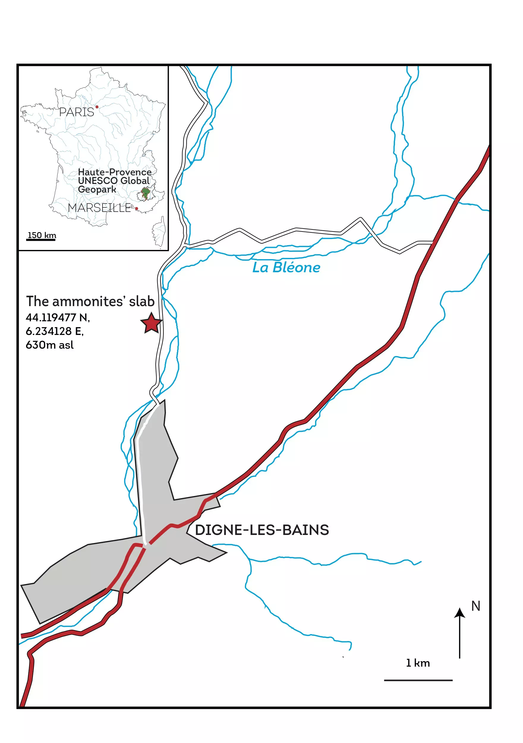
Figure 1. Location of the Les Isnards Ammonite slab.
The Ammonite Slab of Digne-les-Bains is an exposed layer of rock, over a surface of around 320 m2, where more than 1550 whole or fragmentary ammonites and nautili can be seen. The ammonites indicate a Sinemurian (Lower Jurassic) age (Dommergues & Guiomar 2011). The ammonites, often large (up to 70 cm in diameter), are mainly a single species, Coroniceras multicostatum (Fig. 2a, b; Corna et al. 1990; Dommergues & Guiomar 2011). A modest but varied benthic fauna has also been found, mainly bivalves and echinoderms (Pentacrinites). The deposit is much larger than the current outcrop; surface surveys and drilling have shown that it occupies a much greater area, possibly several thousand square meters.
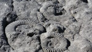
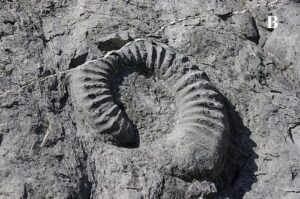
Figure 2. Details of the ammonite Coroniceras multicostatum.
From a geological point of view, the slab belongs to the marly-limestone Liassic sequence of the Subalpine Basin and is part of the Nappe de Digne, a great allochthonous feature running from north to south. The formation to which the fossil-bearing level belongs comprises dark limestone or limestone-clay beds separated by fairly thin beds of marlstones. While the paleoecological conditions that prevailed at the time of deposition were varied, they indicate subpelagic, relatively deep (basinal) environments. It is important to note that the bivalve remains, like the ammonite shells, do not indicate any preferred orientation and therefore no effect of currents (Dommergues & Guiomar 2011).
Heritage Significance
The abundance and size of the ammonites and the size of the exposed surface justify the scientific and heritage interest of the slab, which is unique in France and important globally. Since its discovery, studies have been carried out on taphonomic, paleontological and sedimentological aspects (Corna et al. 1990; Dommergues 2007; Dommergues & Guiomar 2011). Despite this research, some gray areas remain and new studies are required, for example, to explain the high density of the ammonites and the overwhelming dominance of a single ammonite species at this site (and others of the same age in Europe), while normally ammonite paleobiodiversity is much higher.
Geotourism Potential
The Ammonite Slab was gained international popularity even before it was known nationally. This was because of the television series Miracle Planet (Chikyu Daikiko) made by NHK in Japan in 1987. As a result of this publicity, a cast of the lower half of the slab was produced by the teams of the RNNGHP and the Gassendi Museum (the municipal museum of Digne-les-Bains), under the direction of cast-maker René David; the cast was then installed in the city of Kamaishi (Iwate Prefecture) in Japan, where it is still displayed in a specially constructed extension of the local museum, built in 1993 (Fig. 3).

Figure 3. Installation of Ammonite slab cast in Kamaishi Museum, Japan in 1993.
Now, the Ammonite Slab is to some extent the icon of the UGHP, the RNNGHP and the town of Digne-les-Bains. Along with lavender, the other symbol of Haute-Provence, ammonites can be seen in Digne in a variety of situations. Its accessibility and spectacular appearance made the Ammonite Slab a special place for visitors: paleobiodiversity, processes of fossilization, importance of fossils for relative dating, and tectonics are some of the key themes for academics and the public.
The Ammonite Slab plays a major role in the tourist development strategy of UGHP, being relatively close to the Musée-promenade, which is the interpretation center of UGHP, and at the start of the most important of the five discovery roads of the UGHP. It is one of the most visited natural sites in the Apes-de-Haute-Provence. Its scientific and tourist profile has raised awareness among the valley’s inhabitants about the unique nature of their local geology. For all these reasons, conservation of this geosite is of key importance.
As a continuation of this geotouristic interest, the European project The Geological Adventure (ALCOTRA Interreg V-A) was promoted by the Departmental Council of the Alpes de Haute-Provence; it provided new pedagogic equipment thanks to a major phase of work aimed at ensuring the conservation of the site.
Geoconservation
In 1978, the Ammonite Slab was one of 18 sites suggested for the establishment of the RNNGHP. Before that, from the 1960s, the locally based learned society (Société Scientifique et Littéraire des Basses-Alpes, today, des Alpes-de-Haute-Provence) had taken the initiative of enclosing the site to limit access and damage. The first work to clear the slab brought to light around 600 ammonites and confirmed the site to be of major interest (Fig. 4).
Figure 4. First geoconservation works on the slab, 1978.
Juridical protection dates from 1984 with the order establishing the RNNGHP (Decree No. 84-983 of 31/10/1984), which, among others, prohibits the extraction or collection of fossils and any modification of the condition of the site. The effectiveness of this national level of protection was complemented by land control: acquisition of the land by the township of Digne-les-Bains (1988) and then (2018) its assignment to the Departmental Council of the Alpes de Haute-Provence, which has been the administrator of the RNNGHP since 2014.
In the last thirty years, much work has gone into improving the conditions for observation and display of the ammonite slab: the re-routing of the departmental road, protective work against falling rocks and water damage. Thus, in 1994, a second major clearing of the slab was undertaken as part of the Tempus Program, with the support of the University of Bucharest, which led to revealing the entire slab as it is today. In that same year, a field campaign and small-diameter drilling-sampling confirmed that the deposit is not limited to the few hundred visible square meters, but extends to the north under the overlying layers.
The most recent work was carried out in 2019–2020 by the Departmental Council of the Alpes de Haute-Provence as part of the European ALCOTRA Intereg V-A program, The Geological Adventure (Guiomar et al. 2018). This focused on three key points (Bert et al. 2019): (1) the physical conservation of the slab, (2) the conditions for observation and (3) the development of the site’s surroundings, including the educational facilities for the public.
The importance of conservation and the sustainability of the slab itself emerged when voids were found underlying and endangering the fossil-bearing layer. Complete mapping of these voids was carried out using a geophysical radar, followed by mapping the fractures and mechanical stresses on the slab. Problems related to water infiltration, gypsum formation, rock decompaction and human activity, which have greatly accentuated damage to the slab and its ammonites in recent decades, led the Department and the RNNGHP to propose a protection program. This protective work was carried out by systematic anchoring with infilling of the underlying voids and fixing with steel bars, then treatment of cracks and surface holes (Fig. 5). The issue of managing water infiltration upstream of the slab was also dealt with.
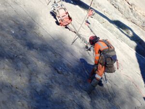
Figure 5. Drilling and anchorage of the slab, 2019.
Until then, the immediate surroundings of the Ammonite Slab had not been the subject of any design, the remainder of the former road acting as car park and reception area. The work carried out as part of the Geological Adventure project has remedied this by offering the public today a reception area worthy of the international stature of the site. A landscaped parking area was installed, thanks to a further re-routing of the road, as well as an area which allows the deployment of appropriate educational materials for any audience, using many tools (models, casts, explanatory panels, a sound system, etc. – Fig. 6). The site itself has been laid out to allow access to persons of reduced mobility using an access ramp to the terminal platform, which gives a new raised view of the slab (Fig. 7). The operation was financed by the Department (€1,020,000), the European FEDER ALCOTRA Fund (€510,000) and the Region (€170,000).
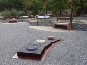
Figure 6. Some of the new interpretation equipment, 2020.
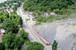
Figure 7. Aerial view of the Les Isnards site, 2020, showing the re-routed road, the parking. area, viewing platform, and access for visitors with reduced mobility.
Conclusion
Thanks to more than 30 years of geoconservation, as well as scientific research and tourism valuation, the Ammonite Slab has evolved from an object of purely scientific interest to a major heritage and tourist site emblematic of the development of geotourism in France, a sector that did not exist 40 years ago and which is booming today. Protection efforts will need to be continued to ensure this site has the future it deserves.