Introduction
The Regional Natural Park (RNP) of the Monts d'Ardèche, located in south-eastern France, obtained the designation of UNESCO Global Geopark in September 2014. At this point, it joined the network of 161 UNESCO Global Geoparks located in 44 countries. It is the 5th designated Geopark, out of seven, in France. Among its many commitments, the Monts d’Ardèche UNESCO Global Geopark is strengthening its involvement in scientific research and outreach to better understand and promote its Permian and Triassic palontological heritage. This includes fossil tracks and trackways of vertebrates, whose scientific study is the field of ichnology. The University of Burgundy (Biogéosciences Laboratory, Dijon, France) has a well-known expertise in paleontology, ichnology and sedimentology and it carries out scientific investigations that overlap with the endeavor of the Monts d’Ardèche UNESCO Global Geopark. Since the late 1960s, this academic institution has contributed substantially to the scientific description of the exceptional ichnological heritage of Ardèche (Demathieu & Samana 1968, Courel & Demathieu 1976, 2000; Courel et al. 1982; Gand 1994; Gand et al. 2005, 2007; Gand & Demathieu 2005; Szewczyk et al. 2020).
This long-standing partnership was formally concretized in November 2015 by an agreement between the RNP of the Monts d'Ardèche and the University of Burgundy. This agreement is based on four components: (1) scientific research, (2) protection of ichnological sites, (2) training of students and professionals, and (4) scientific outreach. The main aims are to make a detailed and sedimentologically contextualized inventory of Triassic vertebrate tracks within the Geopark and its surroundings, to establish conservation and protection priorities, and to set up ichnological geosites for the public (Fara & Gand, 2015; Fara et al. 2019). In this paper, we focus on the Triassic ichnological patrimony of Ardèche and we describe the strategy and initiatives undertaken to promote this remarkable geoheritage.
Geological context and areas of ichnological interest
The Monts d’Ardèche UNESCO Global Geopark is located on the southeastern edge of the Massif Central (southern France). By standing at the interface between plutonic, metamorphic, volcanic and sedimentary rocks, it gathers outstanding geological structures and evidence of their use by people, notably mining and construction. The limits of the Geopark circumscribe much of the regional Permian and Triassic sedimentary rocks that outcrop mainly along a NE-SW strip between the towns of Privas and Les Vans (Fig. 1). Both mining activities and geological mapping contributed to the discoveries of fossil tracks in these rocks, especially in the Triassic (Blanc 1962; Demathieu & Samama 1968; Montenat 1968; Courel & Demathieu 1976, 2000; Courel et al. 1982; Gand 1994; Gand et al. 2005, 2007; Gand & Demathieu 2005).
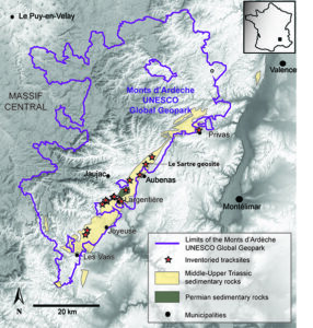
Figure 1. Location of the main Permian-Triassic tracksites inventoried within the Monts d’Ardèche UNESCO Global Geopark and its immediate surroundings. Note the long and narrow strip of Middle-Upper Triassic continental detrital sedimentary rocks that yield numerous archosaur tracks and trackways. Le Sartre, which is the first equipped ichnological geosite within the Geopark, is also indicated on the map. Selected and simplified geological contours are from Saint Martin (2009).
In the stratigraphic series of the eastern edge of the Massif Central, whose nomenclature is complex, three main geological units yield Triassic vertebrate tracks: the “Grès du Roubreau” (sensu Courel et al. 1984 and Bourquin et al. 1995) representing the Middle Triassic (Anisian/Ladinian), and the “Ensemble gréso-dolomitique gris” and “Formation Bariolée d’Ucel” (sensu Bourquin et al. 1995) documenting the Upper Triassic (Carnian/Norian). The former is dominated by conglomerates and sandstones, whereas the latter is characterized by sandstones, microconglomerates and occasional argillite layers. These continental units have a fluvial origin and have been dated palynologically (Rouire et al. 1980; Courel et al. 1984, 1998; Poli et al. 1994; Elmi et al. 1996; Razin et al. 1996; Poli 1998). Together, they have yielded a famous ichnological heritage of reptilian footprints (Gand et al. 2007; Fig. 2).
.jpg)
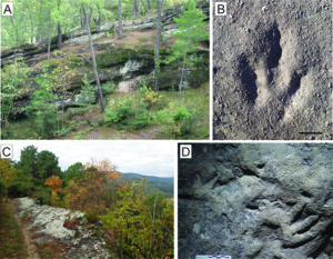
Figure 2. Illustration of the main track-bearing sedimentological units in the Monts d’Ardèche UNESCO Global Geopark. A) Outcrop of the Upper Triassic “Formation Bariolée d’Ucel” at Le Sartre geosite, near Aubenas. The cliff, on the top of which is located the track-bearing surface, is about 10 m high. B) Example of a typical Grallator-like footprint found at Le Sartre geosite and preserved in coarse-grained sandstone (see also Szewczyk et al. 2020). Scale bar is 5 cm long. C) Outcrop of the Middle Triassic “Grès du Roubreau” at Daüs, west of Ailhon. The outcrop on the right side of the pathway is 2-3m wide. D) Chirotherioid tracks of pseudosuchian reptiles from Daüs and currently held in the Musée de Privas, Ardèche. Scale bar is 5 cm long.
Ichnological significance of the Monts d’Ardèche UNESCO Global Geopark
The richness and abundance of Triassic vertebrate tracks within the Monts d’Ardèche UNESCO Global Geopark make the latter an exceptional area. To date, 15 tracksites and nearly 1000 individual tracks have been inventoried within the Geopark limits and its immediate surroundings (Fig. 1). There are still many tracks to be studied, but some of them have already been described scientifically including the erection of several ichnotaxa, such as Isochirotherium felenci, Coelurosaurichnus grancieri, Coelurosaurichnus largentierensis and Dahutherium agilis (Demathieu & Samana 1968; Montenat 1968; Courel & Demathieu 1976, 2000; Gand et al. 2005, 2007; Gand & Demathieu 2005). Although the validity of some of these ichnotaxa can be challenged, they demonstrate the remarkable ichnological potential of the Triassic sedimentary rocks in Ardèche.
Beyond richness and abundance, this ichnological patrimony is also outstanding as it documents major episodes in the macroevolution of Triassic reptiles, most notably dinosaurs (reptiles belonging to the bird lineage) and pseudosuchians (reptiles belonging to the crocodilian lineage). Indeed, Middle Triassic ichnoassemblages in Ardèche illustrate pseudosuchian-dominated faunas (Demathieu & Samama 1968; Courel & Demathieu 1976; Gand & Demathieu 2005; Gand et al. 2007), whereas Late Triassic ichnoassemblages are dominated by dinosaur tracks and trackways (Courel & Demathieu 1963, 1976, 2000; Demathieu & Samama 1968; Gand et al. 2007). Such a contrast is a well-known macroevolutionary pattern documented in Europe, South America, North America and Africa. It illustrates a profound faunal turnover within terrestrial ecosystems that occurred during the Carnian (e.g. Benton, 1986; Bernardi et al. 2018; Benton et al. 2018; Dal Corso et al. 2020). Some lineages suffered major extinctions (rhynchosaurs and dicynodonts), while others first appeared or diversified in that geological interval (crocodylomorphs, dinosaurs, phytosaurs, rauisuchians, rhynchocephalians). Although the dinosaur stem lineage (Dinosauromorpha) first appeared in the Early Triassic (Brusatte et al. 2011), this lineage remained relatively inconspicuous until the Carnian after which it increased in diversity and morphological disparity at the expense of pseudosuchians (Brusatte et al. 2008). The causes and precise timing of this major faunal turnover remain elusive, but the Carnian is now identified as an interval characterized by major paleoenvironmental changes, including the intense volcanism in the Wrangellia Large Igneous Province, the Carnian Pluvial Episode and some perturbations of the carbon cycle (Simms & Ruffell 1989; Hornung et al. 2007; Dal Corso et al. 2012, 2015, 2018, 2020; Sun et al. 2016; Bernardi et al. 2018).
In addition, tracks of Triassic reptiles found in the Monts d’Ardèche UNESCO Global Geopark are unique because of the coarseness of the sedimentary rocks hosting them. An outstanding example is provided by the locality named “Le Sartre” located in the town of Ucel, near Aubenas. It stands out as being the first recognized ichnological geosite in Ardèche. More than 300 reptilian imprints are preserved in a remarkably coarse-grained sedimentary layer corresponding to a medium- to coarse-grained quartz arenite that is microconglomeratic locally. This unusual occurrence challenges prevailing preservation models and it highlights the diversity of taphonomic pathways leading to ichnoassemblages (Szewczyk et al. 2020). It also illustrates the contrasting preservation potential of true tracks (imprints left on the actual walking surface), undertracks (imprints resulting from the deformation of the sedimentary layers below the walking surface) and overtracks (imprints corresponding to a shallow sedimentary cover of true tracks after the latter formed).
Overall, the ichnological significance of the Monts d’Ardèche UNESCO Global Geopark stands in its ability to stimulate scientific questions about ichnodiversity, macroevolutionary transition and taphonomic processes involved in track formation and preservation.
From scientific investigations to education and geotourism: the key role of Geoparks and local actors
The keyword “dinosaur” is a formidable asset for most touristic initiatives (Laws & Scott 2003; Pérez-Lorente 2015; Alcalá et al. 2016; Cobos & Alcalá 2017; Lkebir et al. 2020), so Geopark actors and local authorities have easily perceived the great potential of the regional ichnological patrimony, and they actively contribute to extend and protect the most promising sites. A good example is given by Le Sartre geosite. After four years of scientific investigations and recent extension/installation works, it was inaugurated at the beginning of October 2020 (Fig. 3). This geosite is the first equipped locality in France (and probably in Europe) to show Late Triassic dinosaur tracks and to be freely accessible to the public. Such a success has been made possible by the involvement of local people throughout the process and by the outstanding capacity of all actors to collaborate efficiently with each other. The key partners united by this Geopark initiative are the RNP of the Monts d'Ardèche, the Ucel Municipality and the Biogéosciences laboratory, with financial support by the European LEADER program, the Région Auvergne-Rhône-Alpes, the Département de l'Ardèche, and the community of municipalities from the Bassin d’Aubenas.

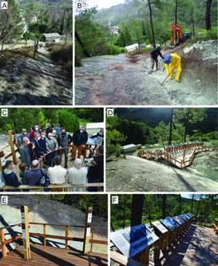
Figure 3. Installation of Le Sartre geosite. A) Aspect of the site before April 2019, as viewed from the South-West. B) Extension works carried out in April 2019 with the help of the Ucel Municipality, academics and local volunteers. The participation of scientists contributed to optimize the operation by checking track-bearing surfaces during excavation. C) Inauguration of Le Sartre geosite the 1st of October 2020. This event gathered all the actors who are contributing to the long-term project of promoting the ichnological patrimony of Ardèche. Photo courtesy of Philippe Lemery. D) Aspect of Le Sartre today, as viewed from the West. E) Visual targeting tubes allowing young and adult visitors to spot well-preserved fossil footprints. F) Richly illustrated explanatory boards associated with touchable 3D replicas of representative footprints.
The Le Sartre geosite was discovered by a naturalist neighbor (Michel Verolet) who first alerted a professional ichnologist (G.G.) back in 2007. This turned out to be the start of a long-term and fruitful collaboration that initiated the study of Le Sartre and the identification of several other important ichnosites in Ardèche. Beyond a shared curiosity for natural objects, the strength of this ongoing partnership comes from the involvement of local amateurs into the Geopark-driven initiatives and by the acknowledgement of their significant contribution at all stages of the process. The rising number of volunteers for recent cleaning or extension works witnesses the expansion of popular enthusiasm (Fig. 4A‒B). Moreover, the early involvement of local people in ichnological investigations helped to improve and consolidate the reciprocal trust between academics and local people. This can be measured, for example, by the increasing number of notifications given by inhabitants to researchers about private specimens and sites that were kept secret until now. The absence of any direct economic or financial benefit is certainly a key factor in consolidating this partnership and transparency. Informal and formal communication further increased the awareness of local people about the nature, richness and patrimonial value of their immediate geological surroundings. In that perspective, we promote the notion of a universal and shared patrimony during all visits, conferences and informal discussions with local inhabitants and tourists alike (Fig. 4C‒D).
.jpg)
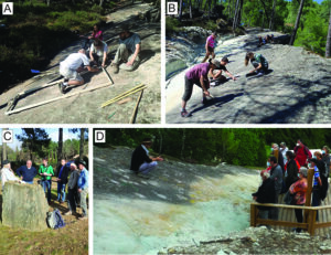
Figure 4. Diversity of actors actively contributing to the awareness of local people about the nature, richness and patrimonial value of their geological heritage. A) Preliminary scientific investigations and preparation of casts in August 2016 by a team composed of local inhabitants, master students and academics. B) Team involving local volunteers, members of the RNP des Monts d’Ardèche and academics during one of the numerous but necessary soft cleaning sessions of the track-bearing surface. C‒D) Academics, members of the RNP des Monts d’Ardèche and teachers instill the notion of a universal, shared and valuable geological heritage to local people and tourists during the numerous formal and informal visits of Triassic tracksites in the Monts d’Ardèche UNESCO Global Geopark.
As expected, the Geopark label also stimulated articulation and coordination among academic actors, local associations and scholarly societies (e.g. Société Géologique d’Ardèche, association Clapas, Le CPIE du Velay), as well as local economic activities and scientific illustrators. The Monts d’Ardèche UNESCO Global Geopark is now able to offer educational toolkits, such as annual conference cycles, geosite maps, rock identification guides and geological timescales illustrated by regional features. All this material is freely available online. Services are also proposed to high-school teachers in order to set up pedagogic activities in natural sciences, geography and history about this regional geological heritage. Visitors at Le Sartre geosite are also self-guided thanks to richly-illustrated explanatory boards, visual targeting tubes and touchable 3D replicas of emblematic reptilian footprints (Fig. 3E‒F).
Furthermore, touristic visits can focus on various themes, one dedicated to tracking dinosaurs as it includes visits to the Le Sartre geosite and a local paleontological museum. Although there is currently no geotrail devoted to ichnology in Ardèche, this possibility is currently being investigated as many ichnosites are located in natural but accessible zones. In addition, this would complement another geosite that is part of a geotrail (Vernon’s tétines and Baumicou waterfall), that presents spectacular erosional features called “tétines” and that also occurs in Triassic sandstones.
Overall, from preliminary scientific investigations to inauguration, Le Sartre geosite illustrates perfectly the transition from an academic-only, discrete scientific study to an equipped geosite that is now frequently advertised on the internet and in both regional and national media.
Conserving Ichnological Geosites in Ardèche: Actions, Solutions and Challenges
In France, natural sites rarely benefit from legal protection based on their geological or geomorphological interests, although several initiatives have been taken nationally over the last decades in order to improve that situation (Billet 2002; Egoroff et al. 2011, 2014; De Wever et al. 2015; Auberger et al. 2018). This includes a nation-wide coordinated inventory of remarkable geological sites (e.g., the national inventory of the geological heritage INPG, imposed by the article L.411-5 from the law n°2002-276 of the 27th of February 2002 and launched in 2007, De Wever et al. 2014), as well as formal protection decrees such as the Prefectural Decree determining the departmental list of the geological sites of interest and the Prefectural Decree of the Protection of the Geotope, APPG, both established in 2015 (e.g., Auberger et al. 2018). Within the Geopark perimeter, only a handful of sites currently benefit from the status of “Natural Monuments” and are therefore protected by national law for their geological or landscape value (e.g. the Mont Gerbier de Jonc, the Mezenc Massif, or the basaltic flows of the Pont du Diable de Thueyts). Unfortunately, at present, paleontological sites, including track-bearing ones, are not part of this list although they certainly include some requiring the most protection.
Beyond legal issues, the main practical challenge for protecting and conserving tracksites in Ardèche are the diversity of land properties and their accessibility. This concerns sites within the Geopark but also the few located outside its formal limits. In the latter case, although access and protection are negotiated on a case-by-case basis, the Geopark label remains an asset in the dialog with land-owners and municipalities. The other, classical issue for tracksites resides in the compromise between extending vs. protecting sites of interest, a conundrum that revolves around scientific curiosity and logistical/touristic/protection constraints. These challenges are briefly presented here through the prism of two concepts: site assessment and protection type.
Site assessment typically relies on an evaluation system. This crucial aspect of conservation (Pérez-Lorente 2015) led our team to provide a list of priorities for the study, protection and conservation of ichnosites. Priorities are assessed using criteria such as scientific interest and novelty, intensity of destructive agents (whether anthropic or not), land property and accessibility. This assessment can also be cross-compared with other patrimonial evaluation criteria proposed by Cendrero (1996), Caro & Pérez-Lorente (1997) and Pérez-Lorente (1998).
The three types of protection summarized by Pérez-Lorente (2015) have also been put into practice for Le Sartre geosite, that will serve as an emblematic example for other ichnological sites within the Geopark. Legal protection was ensured by the repurchase of the originally private land by the local municipality of Ucel, thus transferring the site into the public domain. Physical protection has been achieved through the setting up of fences, walkways overhanging the track-bearing surface, as well as signs and notice boards that explain the fragility of the site (Fig. 3D‒F). No covering structure has been installed so far, although it might prove useful in many instances (Pérez-Lorente 2015). Maintenance protection is very limited as no cement nor resin were necessary on the undertracks on the erosion-resistant sandstones and microconglomerates, nor on the fragile true tracks that erosion will reveal naturally (Szewczyk et al. 2020). Clearly, these aspects require a specific monitoring and adequate actions in the long run. Human activities (construction, circulation, or vandalism) and natural processes such as meteoric agents, floods, shrubs, and covering by lichens and mosses are amongst the major factors susceptible to deteriorate the fine structures and the aesthetic value of most tracksites in the Geopark, including le Sartre geosite.
In addition to traditional casts, and as is now usual for many tracksites around the world, both preservation and valorization are achieved through systematic 3D modeling using photogrammetry (e.g., Lkebir et al. 2020; Szewczyk et al. 2020). The resulting numerical models are used for enhancing exhibitions with new digital techniques (e.g., virtual reality) that are very attractive to visitors. Digitizing tracks, trackways or entire sites also contributes significantly to sharing and preserving this ichnological heritage numerically and to promoting its digital scientific outreach. Importantly, this approach not only concerns on-site reptile track and trackways, but also historical ichnological specimens from this area held in various collections nationwide. Taken together, these data will contribute to the emergence of an exhaustive ichnological inventory that will ultimately be made available to the public.
In terms of decision-making, the RNP Monts d’Ardèche-Monts d’Ardèche UNESCO Global Geopark is at the heart of the process and of nearly all the initiatives taken with local authorities. Inspired by ideas shared within the global Geopark network and with local communities, the Geopark establishes its strategy based on decisions taken in its main internal entities, namely the Council and the Scientific Committee. The latter is composed of a board of national experts of various disciplines that are involved into the study of the local geological heritage.
Summary
The remarkable richness and abundance of Triassic vertebrate traces in Ardèche is an outstanding ichnological heritage in France. This is why an exhaustive inventory of this patrimony, associated with conservation measures, was crucially needed. The excellent dynamics of the ongoing Geopark project is already materialized by Le Sartre, which is the first equipped geosite in France presenting Late Triassic dinosaur tracks to the public. Such a success, achieved within a few years only, results from an exceptional combination of factors and of the notable coordination by the Monts d’Ardèche UNESCO Global Geopark of both local and external actors. But setting up a few geosites with fences or notice boards is not enough. Their long-term maintenance and protection require an endless involvement of all the participants, and the future must be rhythmed by regular educational activities, by field training and academic research projects, and by on-site regular visits and conferences for the public. The designation as a UNESCO Global Geopark clearly marked a turning point from academic-only to coordinated research, conservation and geotouristic initiatives involving local communities.
Acknowledgments
We acknowledge the two reviewers whose comments improved the first version of the manuscript, as well as the Editor-in-Chief Michael J. Benton who improved the style of this contribution. We wish to thank all the local people and volunteers that help us to promote the ichnological patrimony from Ardèche, especially Michel and Véronique Verolet, Roland Fayolle, Suzy Meucci, Laurent Mendras, Maryse Aymes, Georges Naud, and Jean-Daniel Balayn. Suzanne Jiquel is thanked for her decisive help with fossil casts, and the artwork by Pierrick Legobien continues to be admired by all colleagues and visitors. We express our gratitude to the Ucel Municipality for the permission to investigate and promote the geosite of Le Sartre and for making extension works possible. We also acknowledge the financial support by the European Leader program, the Région Auvergne-Rhône-Alpes, the Département de l'Ardèche and the community of municipalities from the Bassin d’Aubenas. Photogrammetry and 3D modeling were essentially performed in the MorphOptics facilities of the GISMO platform (Biogéosciences laboratory, Dijon, France). This contribution is part of the partnership between the RNP of the Monts d'Ardèche-Monts d’Ardèche UNESCO Global Geopark and the Biogéosciences laboratory (University of Burgundy) for the study of Permian-Triassic trace fossils in Ardèche.
Conflict of interest
The authors declare that they have no competing interests.