Introduction.
Poás Volcano National Park was the third most visited protected area in Costa Rica in 2022, with a total of 214 399 visitors, of which 108 784 were residents and 105 615 were non-residents (SINAC 2023). Being an active volcano causes many people to feel attracted to it because they can experience the power of nature (Dóniz-Páez et al 2010; Erfurt-Cooper 2011). Many people enter the Park through official places although in recent years many tourists have risked their lives to enter through illegal places where they could be victims of an eruption; it has been suggested that a geotourism trail could be the solution to this problem (Pérez-Umaña 2017; Beltrán-Yanes et al. 2020).
Geoconservation studies in Costa Rica have been conducted in the last decade to inventory and evaluate volcanic and glacial areas (Pérez-Umaña et al. 2018, 2020; Pérez-Umaña & Quesada-Román 2020), but the origin of geoheritage research in Costa Rica dates back to a first paper by Pérez-Umaña (2017). There is still a long way to go in the country.
The fundamental component in geoheritage is the geomorphosite, defined as a part of the Earth's surface that serves to understand its history and evolution (Panizza 2001). Palacio (2013) mentions that they are objects of geographic interest because of the social connotation since people provide imaginary values to these places, which can provide economic income to communities by using them as tourist attractions (Bouzekraoui et al 2018). A geomorphosite can represent the natural, scientific, and social heritage of the territory (López 2017).
In recent times, Poás volcano has been named as one of the geosites listed in the International Union of Geological Science’s First 100 Geological Heritage Sites [https://iugs-geoheritage.org/] inventory and book (IUGS 2022), which is an additional confirmation of the importance of this volcano for Costa Rica and the world. The aim of the present work is to evaluate geomorphosites in Poás Volcano National Park using the method of Reynard et al. (2016) to determine their importance for the Costa Rican population.
Study area: Geophysical and Cultural Characterization of Poás Volcano National Park
Poás Volcano National Park is located north of the Central Volcanic Range of Costa Rica (Fig. 1) 16 km north of Alajuela City, located within 5 cantons of the province of Alajuela between the geographic coordinates 10°09’40,82” and 10°16’47” north latitude and 84°11’40,33” and 84°16’3,30” longitude west (SINAC 2008; Pérez-Umaña 2017). During 2022, Costa Rica received a total of 2 349 537 visitors, of which 105 615 people visited Poás Volcano National Park (ICT 2023; SINAC 2023), which means that 4,5% of all visitors to the country visited this National Park.
Poás Volcano National Park was created in 1955 by article 6 of the Law N° 1917 of Creation of the Costa Rica Institute of Tourism where it was proposed that the area with a radius of 2 km from the crater would become a national park (SINAC 2008). Subsequently, Article 6 of Law N°1917 was repealed in 1966, but in 1970 the Executive Decree N°1237 was approved, creating Poás Volcano National Park, and its creation was ratified in 1971 with Law N°4714 (SINAC 2008).
This national park has an area of 65.06 km2 and within its boundaries, there is exuberant biodiversity, beautiful volcanic landscapes and diverse eruptive history that make it one of the principal tourist attractions of Costa Rica (Alvarado 2011). Also, this is one of the few volcanoes in Central America to have a road that reaches its crater (Zúñiga 2008).
Geophysical Characterization of Poás Volcano
Poás Volcano is a complex stratovolcano whose maximum altitude is 2708 m above sea level, where three main volcanic structures are located: Principal Crater, Botos Cone and Von Frantzius Cone (Alvarado 2011). Principal Crater is the youngest structure of the volcano with an age of 3500 years, while the Botos Cone and Von Frantzius Cone have ages of 8300 and 4600 respectively (Alvarado 2011). Ruíz et al., (2010) suggest that these three structures are aligned in a south-north direction due to fissure volcanism, while Pérez-Umaña (2017) proposed that these structures are the result of the displacement of the eruptive focus of the volcano.
The evidence of what Pérez-Umaña (2017) proposed is visualized with the Principal Crater, created in the middle of the Botos Cone and Von Frantzius Cone with an eruption that collapsed the south wall of the Von Frantzius Cone. Further north is located the Congo Volcano, an extinct volcano that has had no activity in the last 11000 years. Its location to the north of the Von Frantzius Cone is also evidence of the fissure volcanism mentioned by Ruíz et al., (2010) because it is in an apparent straight line with the other cones mentioned above (Fig. 1).
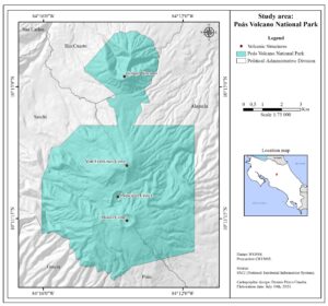
Figure 1. Location of Poás Volcano National Park.
Of all the volcanic structures present in the National Park, the Botos Cone is covered by montane rainforest, characterized by low temperatures oscillating between 6° and 12°C and an excess of humidity, with an average rainfall of between 2200 mm and 4500 mm. The vegetation is semi-evergreen and has a height between 10 and 30 m (SINAC 2008). The high amount of precipitation has caused the formation of a pluvial lagoon within the Botos Cone, which is 400 m in diameter and 14 ms deep and is the source of the waters that serve as a tributary to the Sarapiquí River (Alvarado 2011; Bergoeing 2013).
The last eruptive period of this massif was between 2017 and 2019 (Alvarado et al. 2020). During Easter week of 2017, this activity began with a strong eruption that destroyed the lava dome located inside the Principal Crater (Duarte-González 2018). This dome was the most recent structure inside the crater because it was formed in 1953 by the accumulation of materials expelled by the volcano forming a plug (Alvarado 2011). The dome emanated gases with temperatures of up to 1000 °C (Zúñiga 2008). Before the beginning of this eruptive period, Pérez-Umaña (2017) stated that in an eventual activity of the Poás Volcano, the dome could be the place where this activity would start, and this is just what happened during the 2017 eruptions.
Cultural Characterization of Poás Volcano
Poás Volcano has great importance for the Costa Rican population, having relevance at an economic, historical and cultural level. Being one of the most visited places in the country with 214 399 visitors during 2022 (SINAC 2023), the population living in the surrounding area earns its income by offering food, services, lodging, adventure, and nature activities to tourists, as well as the sale of handicrafts and agricultural products such as strawberries and dairy products (SINAC 2014).
Poás Volcano is important for the Costa Rican population because it has been documented by Costa Rican and foreign naturalists who climbed the volcano to study everything from its geology with its eruptive history and geology, to the temperature and composition of the water that emerges from its slopes (Alvarado 2011). This activity has been an inspiration for different artistic works such as paintings, musical works and literary stories (Pérez-Umaña 2017). According to Alvarado (2011), the first reported eruption of this volcano dates to 1747 when Governor Juan Gemir stated that there was “a volcano of fire”, which showed that the Poás Volcano was active. In 1834 the Danish naturalist Ander Sandoe Oersted documented an eruption of the Poás Volcano describing it as “a strong eruption accompanied by underground detonations and the ashes were thrown up by the volcano to 30 miles away” (Zeledón 2014).
Oersted was one of the first naturalists to document an eruption of Poás Volcano, but other naturalists conducted scientific studies such as the German scientist Alexander Von Frantzius who was one of the first scientists to ascend to the crater of the Poás Volcano and conducted various studies such as the physical-chemical characterization and temperature of the water in the crater lake (Vargas 2014). For this reason, one of the volcanic cones is named after him. This led other scientists to develop different research on the volcano, and many artists were inspired by this volcano (Pérez-Umaña 2017).
The name of the volcano has cultural significance. The indigenous Huetar population of Costa Rica calls it “Chibuzú” which means “Mountain of the God” (Ceruti 2010). Other names by which it was known were “Poasi” or “Puasi”, both being variants of the current name. According to Alvarado (2011), these names began to be heard in 1663 and the reason for this name could be that around the volcano there are many species of thorny vegetation. The term “puas” means in English “thorn”. In addition, Oersted called it Votos Volcano about its proximity to the Botos Cone (Zeledón 2014).
In the literature, Poás Volcano has been the inspiration for legends, myths, stories and verses that show the respect and appreciation of the people, who see the volcano as an ancient guardian that protects the country (Alvarado 2011). Artistic works have also been produced such as paintings that reflect the scenic beauty of the volcano captured on canvas, as well as songs by Costa Rican composers whose melodies describe the beauty of the volcano (Chaves 2014). Also, in the economy and philately, there are examples where images of the volcano have been captured in banknotes and stamps (Alvarado 2013; Chacón 2016). Pérez-Umaña (2017) concluded that the large number of artistic works inspired by this volcano reflects the strong rootedness, that all citizens feel identified with this volcano as part of their country and the environment in which they live.
Another tradition is a hike to the volcano in celebration of San José’s Day. This activity is organized by the Cantonal Sports and Recreation Committee of the Municipality of Poás and takes place in March of each year. It consists of a recreational walk from San Pedro de Poás to the National Park for people to exercise outdoors in the middle of the forest (Ureña 2013). Finally, Ceruti (2010) noted that the volcano was home to the Botos indigenous group, although Arias (2008) and Constenla et al. (2009) indicate that there are no archaeological findings around the volcano. However, this does not detract from its cultural value but rather highlights the importance and level of belonging that Costa Ricans have to this volcano (Pérez-Umaña 2017).
Method
For this research, the methodology proposed by Reynard et al. (2016) was used, which is an integrated approach for geoheritage inventory and management. The methodology has two stages: 1) an inventory of the relief with geomorphological interest within the study area, and 2) an assessment of the selected geomorphosites in the study area. To carry out the first stage, a geomorphological map of the Poás Volcano National Park was used. After selecting the geomorphosites, a detailed bibliographic review was carried out to compile information on the selected reliefs as well as to identify possible geomorphosites that were not identified in the geomorphological map.
The second stage is the assessment of the geomorphosites. Reynard et al. (2016) explain that this evaluation is carried out in four steps. First, the site description (Table 1), which consists of the general characterization of the data of each identified geomorphosite. The second step is the assessment of intrinsic values divided into scientific and additional values. Intrinsic values are the geological and geomorphological values of each geomorphosite, which is specific and unique. Table 2 shows the criteria for the evaluation of scientific values, which is done on a qualitative scale with values between 0 and 1 where 0 is null and 1 is high.
Table 1. General and descriptive data. Adapted from Reynard et al. (2016).
General data of the geomorphosite | |
Data | Description |
Identification Code | This number is important in the location of the site in the synthesis map. Each code has three characters: capital letters for the region, letters for the process, and numerical code for the site. |
Name | Name of the landform or very simplified description of the geomorphosite. |
Toponomy | Area where the geomorphosite is situated. |
Coordinates, Minimum altitude, Maximum altitude. | |
Type | PCT: Punctiform (e.g. erratic boulder). |
Lin: Linear (e.g. valley, dike). | |
AER: Areal (Crater, caldera, dome, cone, plug…). | |
Size | Punctiform: no indication or width [m] (e.g. sinkhole) or volume [m3] (e.g. erratic boulder). |
Linear: length [m]. | |
Areal: surface [m2]. | |
Property | PRI: Private. |
ASS: Association. | |
PUB: Public. | |
COM: Common. | |
Protection status | Description of the protection status of the geomorphosite (inventories, natural reserves, zone of protection of the nature, etc). If existing, precise the name and the number of elements of an inventory or the protection regulation. |
Location map | Location of the site relative to the study area. |
Photographs | Good quality, 300 dpi. |
Descriptive data of the geomorphosite | |
Description | Geomorphological features, archaeological findings, human infrastructures, biotopes related to the site. |
Morphogenesis | Processes responsible for the landform genesis and development and can include temporal information (dating) and landform activity. Moreover, human transformations if existing are also analyzed. |
Table 2. Criteria used for the assessment of the scientific value. Adapted from Reynard et al. (2007) and Reynard et al. (2016).
Criteria | Qualitative assessment | Value |
Integrity | State of conservation of the site. Bad conservation may be due to natural factors (e.g. erosion) or human factors. | 0 = Destroyed |
0.25 = Practically destroyed | ||
0.5 = Partially destroyed | ||
0.75 = Slightly damaged | ||
1 = Intact | ||
Representativeness | Concerns about the site's intrinsic value. Used concerning a reference space (e.g. region, commune, country). All selected sites should cover the main processes, active or relict, in the study area. | 0 = Null |
0.25 = Weak | ||
0.5 = Moderate | ||
0.75 = High | ||
1 = Very high | ||
Rareness | Concerns the rarity of the site for a reference space (e.g. region, commune, country). The criterion serves to identify exceptional landforms in an area. | 0 = More than 7 |
0.25 = Between 5 and 7 | ||
0.5 = Between 3 and 4 | ||
0.75 = Between 1 and 2 | ||
1 = Unique | ||
Paleogeographical interest | Importance of the site for Earth or climate history (e.g. evolution of volcanic landscape). | 0 = Null |
0.25 = Weak | ||
0.5 = Moderate | ||
0.75 = High | ||
1 = Very high | ||
Synthesis of scientific value | A sentence to summarize the scientific importance of the site. | Average |
Table 3. Criteria used for the assessment of the additional values. Adapted from Reynard et al. (2016).
Ecological value | |
Criteria | Qualitative assessment |
Ecological influence | Importance of the geomorphosite for the development of a particular ecosystem or the presence of a particular fauna and vegetation. |
Protected site | Consideration is taken of sites that are already protected in a national inventory, or at regional or local level for ecological reasons. |
Ecological value | A sentence to summarize the ecological value. |
Aesthetic value | |
Criteria | Qualitative assessment |
Viewpoints | Possibilities of the site to be observed. A site covered by a forest or very difficult to access would, in this case, have a lower score than a site visible from several viewpoints. |
Contrasts, vertical development and space structuration | Contrasting landscapes (distinction of colors); landscapes with a vertical development (mountain) or landscapes with individual elements (isolated hill) that give that space structure are generally considered the nicest. On the contrary less contrasting landscapes, flat and monotone reliefs (e.g. alluvial plain, large plateau) are considered as not nice. |
Aesthetic value | A sentence to summarize the aesthetic value. |
Cultural value | |
Criteria | Qualitative assessment |
Religious and symbolic importance | Spiritual and religious influence of the site. |
Historical importance | Role of the site in the past. Presence of vestiges. |
Artistic and literature importance | Presence of the site in artistic realizations (e.g. paintings, sculptures) and in books or poems. |
The assessment of added values is characterized by taking into consideration three qualitative aspects (Table 3). The assessment uses any visual, artistic, literary manifestation, custom or religious belief where the geomorphosite appears or is related to it. Additional values are intangible or subjective as mentioned by Serrano and González (2005), so Reynard et al. (2007) indicate that for the evaluation to be objective, the added values must have a bibliographic basis.
Table 4. Criteria used for the documentation of the protection of the site. Adapted from Reynard et al. (2016).
Subcriteria | Contains |
Protection status | Summarize in one sentence the level of protection of the site relative to its link with different inventories, classifications or natural reserves |
Damages and threats | Specify the level of damage to the site by human activities or natural processes. For the active sites (alluvial area), the change of processes allowing their formation or regeneration can be considered as an attack even if is not localized in the site perimeter. As for threats, one must report if they are based on a real and feasible projection in short/medium term |
The third step deals with the documentation of use and management characteristics, protection status of the geomorphosites concerning human disturbance, signage, and features linked to increasing the educational interest of the geomorphosites. This information is obtained from the Poás Volcano National Park Management Plan (SINAC 2008) because it is the official document for the management of this protected area. Table 4 shows the criteria used for this evaluation.
The last step is the assessment of the site, which is subdivided into two sub-criteria: 1) visiting conditions, and 2) educational interest. In the case of visiting conditions, the following indicators are considered for analysis:
a) Accessibility: takes into consideration three characteristics: 1) Location of the nearest public transportation stop (train station or bus stop) or the nearest parking lot 2) Walking time from the nearest public transportation stop or parking lot, 3) Difficulty of walking (steep slopes, slippery trails, lack of trails, accessibility of trails in rainy season, infrastructure for people with disabilities).
b) Security: it should be documented if any hazards put visitors at risk on the trails. Hazards should be related to trail conditions, such as rock falls, cliffs, and holes that make access difficult, among others. This section does not take into consideration the inappropriate behavior of visitors.
c) Site context: positive and negative aspects related to the geomorphosites and their environment should be considered.
d) Tourist infrastructures: all infrastructures near the geomorphosites are documented, such as transportation, facilities, lodging, toilets, drinking water stations, rest areas, restaurants, and tourist offices, among others.
The following criteria are considered concerning Educational Interest:
a) Interpretative facilities: all existing interpretative facilities such as panels (in situ facilities), brochures and web pages (ex-situ facilities) are taken into consideration because they are considered to be good guides for visitors.
b) Educational interest: the type of visitors and their ability to understand the site are taken into account.
To establish a hierarchy in the assessment obtained from the scientific values, the classification proposed by Bouzekraoui et al. (2017) was used, where ranges are proposed to classify the geomorphosites into low, medium or high values according to the values obtained in the global scientific values (Table 5).
Table 5. Hierarchical classification criteria for geomorphosites. Adapted from Bouzekraoui et al. (2017).
Classification | Ranges |
Low | 0 – 0.4 |
Medium | 0.4 – 0.6 |
High | 0.6 – 1 |
Results and Discussion
Description and Documentation of the Geomorphosites in Poás Volcano National Park
After applying the methodology of Reynard et al. (2007, 2016), five geomorphosites of interest are identified in Poás Volcano National Park, of which three have access through tourist infrastructure such as trails within the protected area. The other two geomorphosites do not have direct access but have visibility points from other locations. Table 6 shows the inventory of the geomorphosites in Poás Volcano National Park and their respective documentary information.
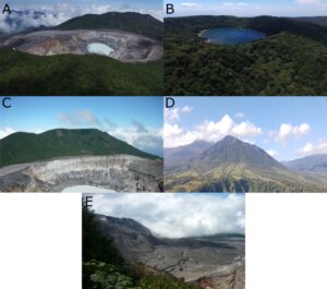
Figure 2. Geomorphosites identified in the Poás Volcano National Park. A) Principal Crater; B) Botos Cone; C) Von Frantzius Cone; D) Congo Volcano; E) Caldera Relic. (Source: Pérez-Umaña 2017).
Table 6. Documentation data of geomorphosites of Poás Volcano National Park.
Geomorphosites | Data | ||||||
Code | Name | Altitude (m) | Surface (m2) | Coordinates | Main Geomorphological Process | Characteristics | Type of geometry |
PVAvol001 | Principal Crater | 2268 | 4961728.29 | 10°11’45” N - 84°14’31” W | Volcanic | Natural | SUR |
PVAvol002 | Botos Cone | 2708 | 1475606.02 | 10°11’12” N - 84°13’36” W | Volcanic | Natural | SUR |
PVAvol003 | Von Frantzius Cone | 2639 | 5804414.65 | 10°12’48” N - 84°13’49” W | Volcanic | Natural | SUR |
PVAvol004 | Congo Volcano | 2014 | 8702450.30 | 10°15’42” N - 84°13’39” W | Volcanic | Natural | SUR |
PVAvol005 | Caldera Relic | 2564 | 136658.05 | 10°11’14” N - 84°14’20” W | Volcanic | Natural | SUR. |
Principal Crater (Fig. 2A) has a diameter of 1320 m and a depth of 300 m, and is in two parts, the Crater and the Acidification Alley (Fig. 3). It is composed of rocks of basaltic and basaltic andesitic origin with ages between 8 ka and 500 ka, spanning the Middle Pleistocene (Chibanian) to Holocene (Ruiz et al. 2010). Inside the crater is a lagoon whose acidity is between 0 and 4 pH with temperatures ranging between 30 ° and 60 ° C (Vargas 2014). This lagoon is of pluvial origin, formed by water from local aquifers near the Crater (Blunda 2010). On the other hand, the Acidification Alley is a rocky plain to the west of the crater that receives the gases emitted by the volcano, so all vegetation that covered it has died. In recent times it has been called the “Canyon of Mordor” for its desert landscapes, although the real name of this area is “Los Quemaderos del Poás” (Pérez-Umaña 2020).
Botos Cone (Fig. 2B) located on the cusp of the Poás volcano massif is composed of basalts and andesites with ages of 8000 years (Ruíz et al. 2010), being one of the youngest geomorphosites of the volcano (Pérez-Umaña 2017). The cone has a diameter of 750 m and an internal pluvial lagoon measuring 400 m in diameter and 14 m deep. The lagoon waters range between 10 ° and 17 ° C (Alvarado 2011) and are of great importance because it is a source of the Sarapiquí River (Vargas 2014).
Ruiz et al. (2010) mention that Von Frantzius Cone (Fig. 2C) is composed of different materials whose ages range between 8000 and 500 ka. Currently, it only has half of its structure because the eruption that gave rise to the Principal Crater destroyed the south wall of the cone exposing the crater of Von Frantzius Cone (Pérez-Umaña 2017).
Congo Volcano (Fig. 2D) is a poorly preserved stratovolcano with a base of 25 km2 and an altitude of 2014 m above sea level. It is composed of basaltic rocks and basaltic andesites with ages between 0.6 ka and 46 ka. It is located north of the Von Frantzius Cone. Its cone has two openings through which several rivers originate (Vargas 2014).
The Caldera Relic (Fig. 2E) is a remnant of an ancient caldera that was located in the massif thousand years ago. It is composed of basaltic rocks and basaltic andesite with ages between 8 ka years and 600 ka (Ruíz et al. 2010). Little is known about this site because it is in a place of difficult access (Pérez-Umaña 2017).
Scientific Value Assessment
The values for scientific values of the geomorphosites identified in Poás Volcano National Park (Table 7) identify the Botos and Von Frantzius Cones as presenting a complete and well-preserved integrity, while Principal Crater, being the site with the highest volcanic activity, is susceptible to modifications by the activity of the crater itself. An example of this is that in the previous century, the lava dome was created, which was destroyed in 2017 by a strong eruption, which is why it is said that the crater is not completely intact. This is why it does not receive a value of 1 in its assessment because its geomorphology was altered (Duarte-González 2018). On the other hand, the Congo Volcano has low evaluations because it has been affected by landslides and the Caldera Relict is located in an area of difficult access so its condition is not well known.
Table 7. Scientific values assessment of the geomorphosites identified in Poás Volcano National Park.
Geomorphosite | Criteria | Global Scientific values | ||||
Code | Name | Integrity | Representativeness | Rareness | Paleographic value | |
PVAvol001 | Principal Crater | 0.75 | 1 | 1 | 1 | 0.94 |
PVAvol002 | Botos Cone | 1 | 0.75 | 0.75 | 1 | 0.88 |
PVAvol003 | Von Frantzius Cone | 1 | 1 | 0.75 | 0.75 | 0.88 |
PVAvol004 | Congo Volcano | 0.5 | 0.75 | 0.25 | 0.5 | 0.50 |
PVAvol005 | Caldera Relic | 0.25 | 0 | 0.25 | 0.25 | 0.19 |
Average | 0.70 | 0.7 | 0.60 | 0.7 | 0.68 | |
Principal Crater and Von Frantzius Cone have very high representativeness. The Poás Volcano Crater is studied and promoted as a site of world interest, but the Von Frantzius Cone receives publicity for being in the foreground and close to the main crater. Cono Botos and Congo Volcano have high representativeness because they are known locally and are points of reference for the population because they are seen from long distances, so people know what they are and how to identify them. On the other hand, the Caldera Relict has a null representativeness because it is not known by anyone and is only known to exist as an ancient remnant of the volcano's origins.
The only geomorphosite with unique rarity is the Principal Crater because it has exceptional beauty and its morphology can change according to the activity of the volcano. The existence of Acidification Alley as well as the destruction of the lava dome are enough evidence to prove that the dynamics of the volcano model the geomorphology of the geomorphosite. The Botos and Von Frantzius Cones are not so unique because their state has not changed in the last thousands of years, their only modifications being caused by seismic activity that causes landslides on their slopes, so they could pass for one more mountain in the landscape of the volcano. The rarity values of the Congo Volcano and the Caldera Relict are even less because they become confused with the landscape and few people know that they are volcanoes and see them as an element of the landscape.
In terms of paleogeographic value, the Principal Crater and the Botos Cone are considered unique because they are clear examples of how to understand the dynamics of an active volcano as well as to understand the dynamics of the morphology of a hydrographic basin. Both elements are of interest because they help to understand the territory and generate land use policies and to understand how a volcano and a watershed are formed. The Von Frantzius Cone has a high value because of its proximity to the Main Crater, but it is not a unique value because the relevance of the Principal Crater is due to its origin and how it destroyed half of the Von Frantzius Cone. Cerro Congo has a moderate value because it is distant from the main crater sources and does not show recent activity. The Caldera Relic has a low paleogeographic interest because it does not describe much of the recent activity of the volcano.
To conclude the analysis of the scientific values using the hierarchical ranking proposed by Bouzekraoui et al. (2017), the Caldera Relic has a low overall value of 0.19 as a geomorphosite with low scientific value. While Congo Volcano enters has a medium value of 0.50 mainly for its representativeness in the northern region of the province of Alajuela. On the other hand, Principal Crater (0.94), Botos Cone (0.88) and Von Frantzius Cone (0.88) are in the high category and are characterized for being the most representative, intact, rare examples, and with the best paleographic history within the Poás Volcano National Park, which is why these geomorphosites are the main attractions of this protected area where the Principal Crater stands out for obtaining the highest value of 0.94.
Additional Value Assessment
In terms of added value, the Poás Volcano has had great relevance for Costa Rican society. Ecologically, the forest that covers the slopes of the volcanic massif has been protected. Since the creation of the national park, its forest cover is protected, and this prevents people from invading the land near the volcano and deforesting it to raise dairy cattle. The national park protects different animal and plant species, and many people travel to the volcano to see these protected species. Therefore, the ecological value of the national park is very important for the Costa Rican population.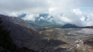
Figure 3. Acidification Alley in Principal Crater (Source: Fieldwork).
The aesthetic value of the Poás Volcano is one of its main attractions because it has views that are worthy of photographs and cause great impressions on visitors. The Principal Crater is widely admired from various viewpoints. Its large dimensions provoke admiration for being in front of a dangerous crater that has been called the largest in the world (Salguero 2003). At the beginning of each year when weather conditions permit, the main crater can be observed together with the Von Frantzius Cone, in addition, the Caribbean plains can be seen, and the top of the Arenal Volcano can also be seen (Fig. 4). There are no objects that alter the visibility so the landscape will always be a volcanic environment where tourists are pleased with its natural beauty.
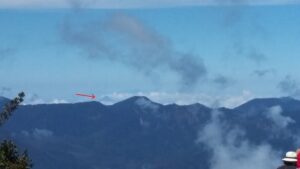
Figure 4. Mountains of Central Volcanic Range. The arrow points to the Arenal Volcano. Only when weather conditions allow it, the Arenal Volcano can be observed from the Poás Volcano. (Source: Field work).
Cultural values are where there is the greatest predominance of information. This volcano was a site of interest for indigenous groups because they considered volcanoes and mountains as sacred lands (Ceruti 2010), although there were no archaeological findings, and it was considered the abode of a God. It has been represented in paintings and photographs nationally and internationally; for example, a photograph of the Poás Volcano was used on a box of matches in the Czech Republic in 2001 (Alvarado 2011), a clear example of how its scenic beauty captivates thousands of people.
In addition, it has been a place of inspiration for tales, stories, poems, and songs, and countless artistic works inspired by this volcano. In the geosciences, there have been many investigations since the first naturalists ascended the volcano in the nineteenth century and to date there are many other investigations in various scientific disciplines. Therefore, the Poás Volcano is important for the local population and foreign visitors, but Costa Ricans have a high sense of belonging and are proud to live with such a magnificent volcano as the Poás Volcano.
Use and Management Characteristics
Protection Values: Protection and Damage-threat Values
The five geomorphosites in this study are located within the Poás Volcano National Park, which means that they have a management category that protects them from any human activity that may affect them. It is worth noting that within the zonification of the Poás Volcano National Park Management Plan, four zones were established for the use of this protected area and the five geomorphosites are located within the Absolute Protection Zone (Fig. 5) which SINAC (2008) describes as a zone that seeks to conserve ecosystems, water resources and ecological processes, as well as to promote scientific research and environmental education.
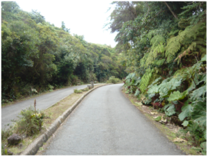
Figure 5. Zonation of Poás Volcano National Park and geocomposites location.
This is important because it restricts the use and visitation of these geomorphosites. In addition, recalling that this is an active volcano, measures must be taken to make sure that people do not risk their lives in case of possible eruptions. In the area of Los Quemaderos, which is also located within the Absolute Protection Area, people have entered illegally. Pérez-Umaña (2020) proposed that this could be avoided if a geotourism route were established so that people would not be exposed to the risk of accidents and to preserve the geodiversity of the volcano.
Therefore, the state of protection of the five geomorphosites is good because they are within a protected area, and an absolute protection zone was established so that no one can enter the volcano illegally, as well as to protect them from economic activities that could cause damage due to intensive use. There are no alterations in the morphology of the geomorphosites, but the only thing that would cause modifications is the volcanic activity itself and geotectonic processes such as landslides that change the shape of the geomorphosites (Quesada & Barrantes 2016).
Since this is a protected area, there are very few works that damage the environment of the geomorphosites; the only interventions caused by people are constructions such as viewpoints (Fig. 6) where the rocks of Principal Crater and the Botos Cone had to be excavated. The access road is well delimited and there is no vehicle access because this road serves as an access for visitors who walk and therefore this infrastructure does not damage any geomorphosite.
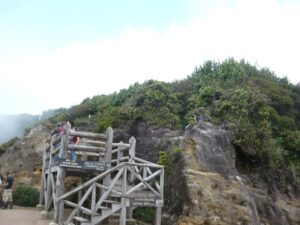
Figure 6. Viewpoint under construction inside the Principal Crater. (Source: Field work).
Promotion Values: Visitation Conditions and Educational Interest
Poás Volcano is one of the few volcanoes in Central America that has a road leading to its crater. At this point, it is important to mention that within the National Park Zonification there is a Public Use Zone (Fig. 5) defined as the area used by visitors to access the main attractions of the volcano (SINAC 2008), in other words, in this area where the road, parking lot, trails and viewpoints are located. This area is located within the Absolute Protection Area, but it is the only area where people can move around and appreciate the flora, fauna and scenic beauty offered by the volcano.
Within the Public Use Zone, there are three main trails: Poor Man’s Umbrella Boulevard, Botos Lagoon Trail and Canto de Pájaros Trail. Of the three trails, the Poor Man’s Umbrella Boulevard is the easiest to walk because it is a well-paved road (Fig. 7). The Botos Lagoon and Canto de Pájaros trails go into the surroundings of Botos Cone where visitors can admire the rainforest. Although they are in good condition, there is a risk of slipping if the trail is wet. In addition, because of the steep slopes, it is possible that a person with a disability may not have access to these trails. The Laguna Botos trail allows access to the interior of Botos Cone to see its pluvial lagoon, while the Canto de Pájaros trail allows visitors to see the forest around the volcano and learn about its bird life.
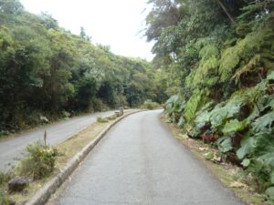
Figure 7. Poor Man’s Umbrella Boulevard. On the right is the Poor Man’s Parasol plant (Gunnera insignis), which gives its name to this boulevard. In the background is a bench for tourists to rest. (Source: Field work).
In terms of security, the trails are safe and wide, but care must be taken only when it rains because the roads become slippery. There is no risk of rockfall or falling down a slope. However, it should not be forgotten that since it is an active volcano, an eruption can happen, and materials can be fired as projectiles and fall on the trails. For this reason, when activity is detected in the volcano, it is closed to the public.
Along the trails, there are different amenities for the use of visitors. There are also restrooms on the Poor Man’s Umbrella Boulevard and at the lookout points for visitors. There are also benches to sit and rest on the boulevard and to admire the Principal Crater and the Botos Lagoon (Fig. 8). The Canto de Pájaros and Laguna Botos trails do not have any facilities, only signs indicating the distance of the trail. In the parking lot there is a visitor's center where you can find all the services mentioned above as well as a cafeteria and a souvenir store where you can buy local articles and food from local producers.
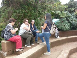
Figure 8. Benches for visitors to rest at the Cono Botos viewpoint (Source: Field work).
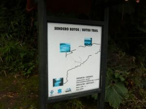
Figure 9. Example of a sign for one of the trails in Poás Volcano National Park. (Source: Field work).
At the viewpoints there are informative panels with relevant information about trails and what people observe from the viewpoint and interesting facts about these structures (Fig. 9). Also, in the visitor's center, there is a museum for visitors to learn about other relevant and interesting aspects of the volcano. Over the years much information has been documented about the volcano, in books, scientific articles and brochures; further, everything is published on the internet and is easily accessible to all people, both visitors and Costa Ricans. The educational interest is very great because visitors are attracted by the volcano, they are interested in learning and knowing everything they can about the volcano and its surroundings.
Visiting conditions are good for visitors to get to know the geomorphosites of this national park. Since it is one of the most important places to promote tourism, the national park has been designed to provide ideal conditions for national and foreign visitors, so accessibility is good, and the trails are safe. Because it is an active volcano, the importance of this volcano as an open-air laboratory for understanding the earth’s dynamics has been taught since elementary school, so there is a lot of information about the dangers of an active volcano as well as about the biodiversity that surround the volcano.
Conclusion
After carrying out the evaluations, it was determined that the most important geomorphosite in Poás Volcano National Park is Principal Crater, with a value of 0.94, entering the high hierarchical category because it has characteristics that make it a unique site of its kind. The Botos and Von Frantzius Cones fall into the same category but with values of 0.88, because their dynamics and geological history are directly or indirectly related to the Principal Crater.
The Costa Rican population has a strong connection with the Poás Volcano massif, which is why there are several artistic works, from literature such as stories and legends to artistic works. There is a strong attachment to this volcano because it is considered a symbol for the citizens and they identify with this volcano. In addition, it has been a place for naturalists to conduct research in the past to understand its dynamics and today it is an attractive place for visitors who take advantage of the road that reaches its crater to visit an active volcano.
Since it is a national park, there are restrictive conditions for human activities, in addition to the fact that since it is an active volcano, regulations were established to prevent people from being in the vicinity of the volcano. The use and management of the national park is controlled by the Management Plan and there are no anthropogenic threats that affect the integrity of the geomorphosites and the only threat to visitors is the volcano itself. There are ideal conditions for visitors considering that it is one of the few volcanoes in Costa Rica and Central America where there is a road that reaches the crater, and there is a lot of information on posters and the internet about the volcano.
The methodology implemented can readily be replicated in other places in Costa Rica and even to make comparisons. We recommend its wide use in other places.
Acknowledgment
The author thanks the editor in charge of this special volume of “Geoconservation in Latin America and Caribbean” for the invitation to write about the geoheritage and geodiversity of Costa Rica. Thank you very much for this valuable opportunity. Thanks to the anonymous reviewers for their comments to improve the content of this article.
Conflict of Interest
The author has no known conflict of interest.
References
Alvarado G (2011). Los volcanes de Costa Rica: geología, historia, riqueza natural y su gente. San José, Costa Rica: EUNED.
Alvarado G (2013). Los volcanes han influido en la cultura y el arte de Costa Rica. http://www.nacion.com/ocio/artes/volcanes-influido-cultura-Costa-Rica_0_1360663943.html
Alvarado G, Esquivel L, Sánchez B, Alfaro J (2020). Actualización del peligro volcánico del Poás, Costa Rica. https://www.cne.go.cr/reduccion_riesgo/biblioteca/informes/Amenaza%20Volcanica%20Poas%20CNE%202020.pdf
Arias M (2008). Identificación y valoración de Nuevos Servicios Turísticos en el Área de Uso Público del Parque Nacional Volcán Poás. Dissertation, Universidad Nacional de Costa Rica.
Beltrán-Yanes E, Dóniz-Páez J, Esquivel-Sigut I (2020). Chinyero Volcanic Landscape Trail (Canary Islands, Spain): A geotourism proposal to identify natural and cultural heritage in volcanic areas. Geosciences 10: 453. doi:10.3390/geosciences10110453
Bergoeing JP (2013). River Landscapes of Costa Rica. San José, Costa Rica: EUNED / Editorial Tecnológica de Costa Rica.
Blunda Y (2010). Percepción del riesgo volcánico y conocimiento de los planes de emergencia en los alrededores del Volcán Poás, Costa Rica. Revista Geológica de América Central. 43: 201–209.
Bouzekraoui H, Barakat A, Touhami F, Mouaddine A & El Youssi M (2017). Inventory and assessment of geomorphosites for geotourism development: a case study of Aït Bou Oulli valley (central High-Atlas, Morocco). Area. 50: 331–343. https://doi.org/10.1111/area.12380
Bouzekraoui H, Barakat A, El Youssi M, Touhami F, Mouaddine A, Hafid A & Zwolinski Z (2018). Mapping geosites as gateways to the geotourism management in central High-Atlas (Morocco). Quaestiones Geographicae. 1: 87–102.
Chacón M (2016). La figura femenina en las monedas de Costa Rica (1845-2016). San José, Costa Rica: Fundación Museos del Banco Central de Costa Rica.
Chaves F (2014). Canción “A la sombra del Poás” resalta las tradiciones y paisajes de Alajuela. https://www.nacion.com/viva/musica/cancion-a-la-sombra-del-poas-resalta-las-tradiciones-y-paisajes-de-alajuela/TN5JLKQQYZH33BQZNQ7KMJQWHU/story/
Ceruti M (2010). Los volcanes sagrados en el folclore y la arqueología de Costa Rica. Mitológicas. 25: 39–50.
Constenla A & Ibarra E (2009). Mapa de la distribución territorial aproximada de las lenguas indígenas habladas en Costa Rica y sectores colindantes de Nicaragua y de Panamá en el siglo XVI. Lingüística Chibcha. 28: 109–112.
Dóniz-Paéz J, Guillén C, Becerra-Ramírez R, Kereszturi G (2010). Volcanes y turismo, patrimonio, atractivo, recurso y producto. Turismo. 2: 73–79.
Duarte-González E (2018). Transformaciones geomorfológicas radicales del cráter del volcán Poás: erupciones de abril de 2017. Revista Geográfica de América Central. 61E: 155–174. http://dx.doi.org/10.15359/rgac.61-4.8
Erfurt-Cooper P (2011). Geotourism in Volcanic and Geothermal Environments: Playing with Fire. Geoheritage. 3: 187–193. doi:10.1007/s12371-010-0025-6
ICT, Instituto Costarricense de Turismo (2023). Situación del turismo en Costa Rica 2022. https://www.ict.go.cr/es/documentos-institucionales/estad%C3%ADsticas/informes-estad%C3%ADsticos/monitoreo-tur%C3%ADstico/2324-monitoreo-trimestral-2023/file.html
IUGS (2022). The First 100 IUGS Geological Heritage Sites. https://iugs-geoheritage.org/videos-pdfs/iugs_first_100_book_v2.pdf
López R (2017). Valoración de geomorfositios en la caldera de Huichapan, Hidalgo, como alternativa de fomento a la geoconservación del paisaje desde la perspectiva de geoparque. Dissertation, Universidad Autónoma del Estado de México.
Panizza M (2001). Geomorphosites: Concepts, methods and examples of geomorphological survey. Chinese Science Bulletin. 46: 4–6.
Palacio J (2013). Geositios, geomorfositios y geoparques: importancia, situación actual y perspectivas en México. Investigaciones geográficas, Boletín del Instituto de Geografía, UNAM. 82: 24–37.
Pérez-Umaña D (2017). Evaluación del potencial turístico de Geomorfositios en el Parque Nacional Volcán Poás. Dissertation, Universidad Nacional de Costa Rica.
Pérez-Umaña D (2020). Un lugar para establecer una ruta geoturística: Los Quemaderos del volcán Poás. https://delfino.cr/2020/09/un-lugar-para-establecer-una-ruta-geoturistica-los-quemaderos-del-volcan-poas
Pérez-Umaña D, Quesada-Román A, De Jesús J, Zamorano J, Dóniz-Páez J, Becerra-Ramírez R (2018). Comparative analysis of geomorphosites in volcanoes of Costa Rica, Mexico and Spain. Geoheritage. 11: 545–559 https://doi.org/10.1007/s12371-018-0313-0
Pérez-Umaña D, Quesada-Román A, Zangmo-Tefogoum G (2020). Geomorphological heritage of Irazú Volcano, Costa Rica. International Journal of Geoheritage and Parks. 8: 31–47.
Reynard E, Fontana G, Kozlik L, Scapozza C (2007). A method for assessing the scientific and additional values of geomorphosites. Geographica Helvetica. 62: 148–158. http://doi.org/10.5194/gh-62-148-2007
Reynard E, Perret A, Bussard J, Grangier L & Martin S (2016). Integrated approach for the inventory and management of geomorphological heritage at the regional scale. Geoheritage. 8: 43–60. https://doi.org/10.1007/s12371-015-0153-0
Ruíz P, Gazel E, Alvarado G, Carr M,Soto G (2010). Caracterización geoquímica y petrográfica de las unidades geológicas del macizo del volcán Poás, Costa Rica. Revista Geológica de América Central. 43: 37–66.
Quesada A, Barrantes G (2016). Procesos de ladera cosísmicos del Terremoto de Cinchona (Costa Rica) del 8 de enero de 2009. Cuadernos de Geografía, Revista Colombiana de Geografía. 25: 217–232.
Quesada-Román A & Pérez-Umaña D (2020). Tropical paleoglacial geoheritage inventory for geotourism management of Chirripó National Park, Costa Rica. Geoheritage. 12: 58. https://10.1007/s12371-020-00485-0
Salguero M (2003). Volcanes de Costa Rica. San José, Costa Rica: Editorial Costa Rica.
Serrano E & González J (2005). Assessment of geomorphosites in natural protected areas: The Picos de Europa National Park (Spain). Géomorphologie: Relief, Processus, Environment. 3: 197–208.
SINAC, Sistema Nacional de Áreas de Conservación (2008, Febrero). Plan de Manejo del Parque Nacional Volcán Poás. https://www.sinac.go.cr/ES/planmanejo/Plan%20Manejo%20ACC/Parque%20Nacional%20Volc%C3%A1n%20Po%C3%A1s.pdf
SINAC, Sistema Nacional de Áreas de Conservación (2014). Plan de Turismo Sostenible del Parque Nacional Volcán Poás. https://www.sinac.go.cr/ES/transprncia/Planificacin%20y%20Gestin%20BID/Gesti%C3%B3n%20Sostenible%20del%20Turismo%20en%20ASP/Planes%20de%20Turismo%2010%20ASP/Plan%20de%20Turismo%20Sostenible%20del%20PN%20Volc%C3%A1n%20Po%C3%A1s.pdf
SINAC, Sistema Nacional de Áreas de Conservación (2023). Informe Anual Estadísticas SEMEC 2022: SINAC en Números. https://www.sinac.go.cr/ES/transprncia/Informe%20SEMEC/Informe%20SEMEC%202022.pdf
Ureña D (2013). Áreas Protegidas y Parques Nacionales de Costa Rica: Volcán Poás. http://areasyparques.com/volcanes/volcan-poas/
Vargas G (2014). Geografía de Costa Rica. San José, Costa Rica: EUNED.
Zeledón E (2014). Viajes por Costa Rica, Tomo I. San José, Costa Rica: EUNED.
Zúñiga R (2008). Guía de Parques Nacionales de Costa Rica. Madrid: Jomagar.