Introduction
The Swabian Jura (Schwäbische Alb) is a low mountain range in Southwest Germany, about 200 km long and 40 km wide (Fig. 1). It is part of the Jurassic mountain range that extends from France to Southern Germany along the Franco-Swiss border. Together with the Franconian Jura, the Swabian Jura forms the youngest unit of the southern German cuesta landscape. About 15 million years ago, the impact of a meteorite formed the Ries crater, near Nördlingen, which now separates the two Jurassic mountain ranges (Geyer & Gwinner 1991).
This youngest cuesta landscape unit consists of Jurassic marine deposits. During the Late Jurassic, Southern Germany was covered by an epicontinental sea, being part of the northern Tethys shelf. In contrast to the Lower and Middle Jurassic, where dark clays predominate, the Upper Jurassic of Southern Germany is characterized by light-colored limestones and marls, which range in thickness 400–600 m (Schmid et al. 2005). During the Alpine orogeny and the formation of the Upper Rhine Graben, the strata were tilted to the southeast, exposing the northwest side of the Swabian Alb, which has since been gradually eroded. Today, the northwestern edge thus forms a very prominent steep slope, the so-called Albtrauf. Towards the southeast, the Jurassic strata lay below Tertiary sediments of the North Alpine Foreland Basin (Molasse Basin) (Fig. 2; Geyer & Gwinner 1997).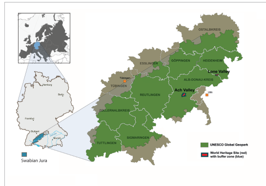
Figure 1. Location of the Swabian Jura. The Swabian Alb UNESCO Global Geopark (green) corresponds approximately to the area setting of the Swabian Jura and its districts (light brown). (Map of Europe modified after: BillFromTheHill at German Wikipedia, transferred from de.wikipedia by W like wiki., CC BY-SA 3.0).
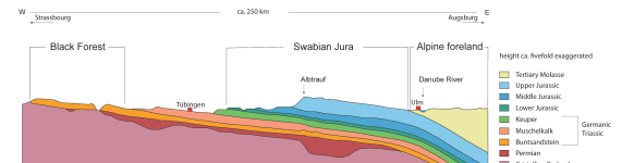
Figure 2. Geological profile of the southern German cuesta landscape including the Black Forest massif, the Swabian Jura and parts of the Alpine foreland (modified after Geyer & Gwinner 1986, 7, fig. 5).
The high plateau of the Swabian Jura consists of Upper Jurassic carbonate rocks, mainly limestones, calcareous marls and dolomites. These rocks typically show small-scale facies changes. Well-bedded marls and limestones occur next to massive limestones formed of algae sponge bioherms (Gwinner 1976). Local rivers carved these massive formations, more resistant to erosion than the stratified limestones and marls.
With more than 2,800 documented sites, the karst landscape of the Swabian Jura is the most cave-rich region in Germany. The Hohle Fels, literally the “hollow rock” (Fig. 3), with its long archeological sequence is a key site for the investigation of activities by Neanderthals (Middle Paleolithic) and Anatomically Modern Humans (Upper Paleolithic) during the Weichselian glaciation. The early Upper Paleolithic archeological horizons yielded early examples of Pleistocene art and musical objects as well as numerous objects of every-day activities (Conard 2009; Conard et al. 2009).
In this paper, we evaluate the protection measures of the archeologically and geologically significant monument Hohle Fels Cave in the Central Swabian Jura (Figs. 4, 5), which developed in one of the massive limestone rocks and revealed a unique sequence of Paleolithic horizons.
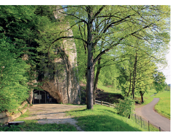
Figure 3. View of the entrance of Hohle Fels Cave as seen from the northeast (photograph by Edgar Sobkowiak, Schelklingen).
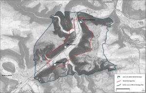
Figure 4. Ach Valley and location of main archeological sites in the World Heritage site, including Hohle Fels Cave.
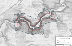
Figure 5. Lone Valley and location of main archeological sites in the World Heritage site.
The Hohle Fels Cave
Hohle Fels Cave is one of 12 caves in the Swabian Alb UNESCO Global Geopark (SAUGGp) that are open to visitors from May to October. During winter the cave is closed according to bat protection regulations.
The cave is situated in a massive limestone reef of the Upper Jurassic with its entrance opening to the north (Fig. 6). A 29 m long corridor leads to a large cave hall, 30 m in height. This hall, created at the crossing of two fissures, is a good example of a cave formed by mixture corrosion as described by Bögli (1964). Archeological excavations in another smaller cavity, preceding the large cave hall, have produced many finds over the last three decades (Barth 2007; Conard 2009; Taller 2014).
The dome-shaped cave hall has a floor space of approximately 500 m². Two corridors to the right and left of the entrance end after about 20 m. Since these areas have not been archeologically examined, their full extent is not clear. A chimney-like opening in the ceiling at the back of the cave let material from the outside enter the cave. As a result, a cone of debris consisting of fallen limestone blocks and sediment slopes down from the back of the cave hall towards the tunnel-like entrance (Bataille & Conard 2018a). The opening, however, was artificially closed in the 1960s both as a safety measure, as it had been a hazard for visitors, and the protection of the cave and its precious geological interior.
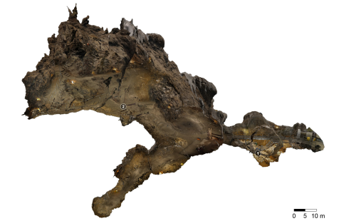
Figure 6. 3D-overview of Hohle Fels Cave. The excavations take place in the tunnel-like entrance which can be seen in the lower right part of the image (modified, image by Markus Steffen and Christoph Steffen, Landesamt für Denkmalpflege im RP Stuttgart). 1 – area of excavation; 2 – main hall.
Numerous geological structures such as large scours on the cave wall and ceiling and centimeter-sized scallops (Fig. 7) – asymmetric depressions on the cave wall – evidence the work of flowing water. At the end of the side passage, to the left of the cave hall, water accumulates in a shallow pool about 1–2 m in diameter. Large stalactites are no longer present in the Hohle Fels Cave. According to Quenstedt (1872), existing “marble” structures, probably limestone sinter, had been removed in earlier times. Nonetheless, speleothems such as flowstones and soda straw stalactites are still present, and a large surface covered by coatings of moonmilk is of particular interest (Fig. 8). The soft, bright white substance has high water content and consists mainly of microscopic calcite crystals, which are often associated with microorganisms (Reitschuler et al. 2012).
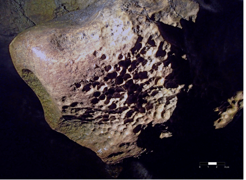
Figure 7. Scallops discovered on a ledge in the area of the main cave hall (photograph by Otto Schwabe, Schelklingen).
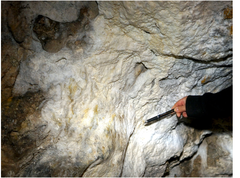
Figure 8. Moonmilk coatings on the southern wall of the main cave hall (photograph by Conny Meister, Landesamt für Denkmalpflege im RP Stuttgart).
Significance of Hohle Fels as Cultural Heritage
In addition to its geological relevance, the cave has a long history of archeological research. The first archeological investigations in the cave were undertaken over 150 years ago by the head of the Stuttgarter Naturalienkabinett and archeological pioneer Oscar Friedrich Fraas (1872). From the first half of the 20th century, excavations increased including those by important archeologists, such as Gustav Riek and Joachim Hahn (Conard et al. 2015). Archeological excavations under the supervision of Nicholas J. Conard started in 1997 and continue to the present (Figs. 9, 10). The sequence of archeological horizons in the Hohle Fels reaches from the Middle Ages back to the Middle Paleolithic, when Central Europe was inhabited by Neanderthals (Homo neanderthalensis). Seven archeological horizons have revealed artifacts from the Aurignacian period and are associated with anatomically modern humans (Homo sapiens). Interrupted by an occupational hiatus during the glacial maximum (Marine Isotopic Stage 2), an Upper Paleolithic archeological sequence from around 42,000–14,000 calBP, interrupted by archeologically sterile horizons during the Second Glacial Maximum, indicates the presence of modern humans during the second part of the Würm/Weichselian glaciation.
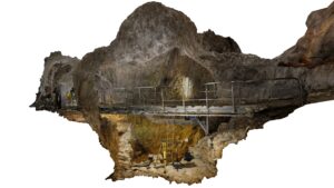
Figure 9. Photogrammetric model of excavation area in the tunnel-like entrance of Hohle Fels Cave. (image by Markus Steffen and Christoph Steffen, Landesamt für Denkmalpflege im RP Stuttgart).
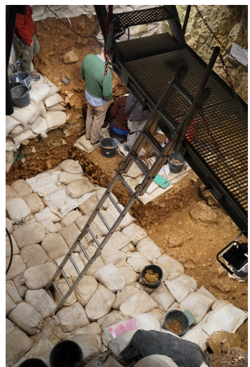
Figure 10. Excavation by the University of Tübingen in the area of the cave’s entrance (photograph by Conny Meister, Landesamt für Denkmalpflege im RP Stuttgart).
Within these layers, carved mammoth ivory figures have been discovered. Representations of a water bird (Fig. 11), a horse head and a small human figure (“Little Lion Man”) have been identified among them. Outstanding, however, is a female statuette, also known as “Venus of Hohle Fels”. Found in the lowest Aurignacian layer, it thus is one of the earliest mobile representations of a human worldwide. Moreover, numerous pieces of personal ornaments such as ivory beads made from mammoth tusks, perforated animal teeth as well as perforated scallops were discovered in the same layers (Wolf 2015). In addition, an almost complete bone flute, fragments of two flutes made of mammoth ivory and a flute blank made of bone were found, and, to date, belong to the oldest musical instruments in the world (Conard et al. 2009).
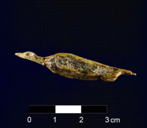
Figure 11. About 40.000 years old ivory figurine of a waterfowl (4.7 cm) discovered in the Aurignacian layers of Hohle Fels Cave (photograph by Juráj Liptak, University of Tübingen).
UNESCO World Heritage “Caves and Ice Age Art in the Swabian Jura”
Because of its archeological and research historical significance as well as its status as a well-documented archeological archive, the site Hohle Fels is part of the UNESCO World site “Caves and Ice Age Art in the Swabian Jura” (Kind et al. 2016). On 9th of July 2017, at its 42nd meeting in Krakow, Poland, the World Heritage Committee decided to inscribe the site in the World Heritage List according to criterion three (iii), because the site “represent[s] a unique or at least exceptional testimony to a cultural tradition or to an existing or extinct culture”. The fact that unique archeological finds and find layers have been discovered in at least six caves of the river valleys of Ach and Lone in the Swabian Jura justifies the site’s addition to the World Heritage List. Hohle Fels is one of those six caves. Excavations of the archeological layers in these caves, which also include Vogelherd, Hohlenstein Stadel, and Bockstein Cave in the Lone Valley, as well as Geißenklösterle and Sirgenstein Cave in the Ach Valley, yielded at least 50 animal and human figures carved from mammoth ivory, eight flutes and further fragments made of bone and mammoth ivory (Hahn & Münzel 1995; Conard et al. 2004), hundreds of objects of personal adornment such as ivory beads and pierced animal tooth pendants (Wolf 2015), as well as thousands of lithic and organic artifacts of everyday life (Riek 1934; Hahn 1988; Barth 2007; Moreau 2009; Taller 2014; Bataille & Conard 2018a, b; Kind 2019). The sediments in the Aurignacian horizons in the region have been dated to between 43,000 and 35,000 BP (Conard & Bolus 2008; Higham et al. 2012; Bataille & Conard 2018a; Kind 2019).
The valleys of the rivers Ach and Lone (Figs. 1, 4, 5), in which the aforementioned caves are located, have a length of 3–4 km each and cover an area of about 190 ha (Lone Valley) and 270 ha (Ach Valley). The Ach Valley is the location of the Hohle Fels Cave, and it is located about 15 km west of Ulm. The section of the World Heritage site runs for about 3 km, with a maximum bed width of ~500 m in a SW–NE direction between Schelklingen and Blaubeuren (Alb-Donau district). The river Ach flows off to the northeast in a valley formerly created by the Urdonau (Danube River) and into the River Blau near Blaubeuren. The Urdonau had originally carved the valley about 200 m deep in the area of the World Heritage site. During the Pleistocene, it was partly filled by the tributaries of the Danube up to the present level. Today, the plateaus of the surrounding area rise up to 700 m above sea level. They limit the valley area to the southeast and northwest, which is about 150 m lower. Most caves and debris have been discovered around the steep valley slopes. The municipalities of Schelklingen and Blaubeuren enclose the area of the World Heritage site to southwest and northeast. In terms of width, the upper edges of the valleys and plateaus form the border of the cultural heritage site.
Swabian Alb UNESCO Global Geopark
The Swabian Alb Geopark began as a national Geopark in 2002 and was designated as a European and Global Geopark in 2004. On 17th November 2015, it became part of the UNESCO Global Geopark network. It comprises all ten districts of the Swabian Alb and covers an area of around 6,200 km2 (Federal State of Baden-Württemberg, Germany).
This largely corresponds to the area of the Swabian Jura (Fig. 1). Eight of Germany's 77 national geosites are located in the Swabian Alb UNESCO Global Geopark (SAUGGp). The Swabian Jura has five UNESCO labels, including the World Heritage sites “Caves and Ice Age Art in the Swabian Jura”, “Upper Germanic-Rhaetian Limes” and “Prehistoric Pile Dwellings around the Alps” as well as the Biosphere Reserve Swabian Alb. Since the geology is predominantly characterized by Jurassic marine sediments, Tertiary molasse and local relics of Tertiary volcanism, the most prominent geological sites are comprised of internationally unique fossil sites such as Nusplingen (Upper Jurassic), Holzmaden, Dotternhausen (Early Jurassic) and Steinheim (Neogene). Geologically significant are the Steinheim impact crater (Miocene), the Urach volcanic field (Miocene) and the eponymous reference localities for the Pliensbachian (Lower Jurassic) and the Aalenian (Middle Jurassic) stages.
The management headquarters is based at the southeastern edge of the SAUGGp area in Schelklingen, which owns the Hohle Fels. The Geopark advises the council of Schelklingen on issues of geoconservation and, if necessary, indicates the course of action to be taken.
Status and Protection of the Geological and Cultural Heritage Site Hohle Fels
The caves of the World Heritage site and the Geopark are archeological monuments, geosites, biological habitats, cultural assets, travel destination and trademark of the region, all at the same time. Both the World Heritage site in general and the caves in particular have an impact on the interests of various representatives and institutions in the region and beyond. The different requirements for the preservation, protection, research and presentation of the archeological remains can potentially be contradictory. Moreover, issues of urban development, agriculture, forestry and tourism also bear a great potential for conflict.
Not least because of these circumstances, the protection of the caves as important geosites was already considered when the Swabian Alb was inscribed as a UNESCO Global Geopark. Another major task of the UUGpSA is to embed the geological significance of the Swabian Jura in the public consciousness and to raise interest in geological history, while preserving this heritage and, with it, the habitat of plants and animals at the same time.
The Swabian Alb UNESCO Global Geopark works closely with the State Office for Geology, Raw Materials and Mining (LGRB), proposing geosites for protection in the region and reporting current changes and possible threats. Since 1936, the geosite Hohle Fels has been protected as a natural monument (geosite protection, passed in 1936; renewed in 1976). In Germany, the protection of natural monuments is regulated by the Federal Nature Conservation Act, which was passed in 1976.
The protection of individual geosites is not explicitly anchored in the German Federal Nature Conservation Act (BNatSchG). However, their protection can be based on their function as a habitat, as a biotope worthy of protection according to § 30 BNatSchG, or based on § 23 BNatSchG due to "rarity, special character or outstanding beauty" as a natural monument. Geosites can also be protected due to their location within the area of larger protected areas. In the federal state of Baden-Württemberg, caves and sinkholes are specially protected as biotopes according to § 33 (NatSchG).
In Baden-Württemberg, the State Office for Geology, Raw Materials and Mining has so far recorded more than 5,200 geosites in a geosite register (LGRB 2021). Based on this, a geosite management concept for 438 geosites located in the area was developed by the UGGp Swabian Alb in 2017. The concept includes rules for their possible integration into geotourism offers, a maintenance concept and suggestions for their protection (Pietsch & Huth 2017). More than 250 of the recorded geosites, including the Hohle Fels, have been either designated as natural monuments or protected by the NatSchG or the Monument Protection Act (DSchG) by their location in protected areas. However, detailed mapping has demonstrated that a large proportion of the geosites have at least a low degree of structural damage.
The large area involved means that continuous evaluation of the condition of recorded geosites in the SAUGGp takes a great deal of effort. However, an important contribution is made by the members of the advisory board and the local geopark network, responsible communities, as well as landscape and cave guides. This helps to ensure the SAUGGp’s linkage to local communities and, at the same time, enables the SAUGGp to respond quickly to negative changes.
The Federal Republic of Germany, because of cultural sovereignty of the Federal states (Bundesländer), and the State of Baden-Württemberg are accountable for the protection and management of the UNESCO World Heritage site “Caves and Ice Age Art in the Swabian Jura”. The Ministry of Economics, Labor and Housing is the highest authority for the protection of historical monuments in the State of Baden-Württemberg, while the State Office for Cultural Heritage in Baden-Württemberg (Landesamt für Denkmalpflege im Regierungspräsidium Stuttgart, LAD) is responsible for technical issues and ensures compliance with the federal monument protection law.
Since inscription in the World Heritage List does not offer any legal protection, the main instrument for safeguarding the site is the Monument Protection Act of the respective nation or state. The State of Baden-Württemberg passed its Monument Protection Act in 1972. The complete World Heritage site has been listed as a cultural monument according to § 2 of the aforementioned act. Since 2014, the site has also been designated as an excavation protection area (§ 22). Within such areas, any activities that may endanger hidden cultural monuments, such as archeological excavations or other activities that result in ground intervention, require a permit. Moreover, the six caves with layers dating to the Aurignacian period are specially protected as monuments of particular importance (§ 12 of the Monument Protection Act).
Other protective mechanisms and legal enforcements that may not be part of the geosite protection include protected biotopes, landscape protection areas, Natura 2000 areas (all Federal Nature Conservation Act) and woodland protection (Woodland Protection Act, passed in 1996). They further strengthen the protective structures of the World Heritage site.
As already mentioned, a section of the World Heritage Site is part of the UNESCO Swabian Alb Biosphere Reserve, which is located entirely within the SAUGGp area. As already mentioned above, a section of the World Heritage site and the SAUGGp is part of the UNESCO Biosphere Reserve Swabian Alb. The management of the latter strives for sustainable development of the whole region, incorporating business interests, settlement activity and tourism jointly with the concerns of nature and environment.
Management World Heritage Site
As part of the management of World Heritage sites, the LAD also controls compliance with the law on the protection of historical monuments by means of a coordinated monitoring program. The site managers are responsible for this task. Other LAD tasks include communicating with all stakeholders, such as tourism organizations, the research community and the people living in and around the World Heritage site. It is especially important to communicate the cultural, historical and geological values of the World Heritage site itself and, in particular, its outstanding universal value, to the public. Thus, one of the core tasks of the educational program is to convey to visitors the respective World Heritage site and to promote measures of protection and preservation.
For each UNESCO World Heritage site, a management plan is drafted to ensure the protection, conservation and mediation of the site and its values. The declared goal of the management plan established by the LAD and its stakeholders for the “Caves and Ice Age Art in the Swabian Jura” was to optimize and further develop the existing protective mechanisms. In the long run, this can only be achieved through communication, exchange and sustainable cooperation between all stakeholders involved. The following objectives have been identified:
- Safeguarding and preservation of the existing archaeological property, including landscape, sites and archeological finds,
- Development of protective measures,
- Increase of scientific knowledge about the cultural heritage by archeological investigations (surveys and test-excavations),
- Conflict avoidance and conflict management,
- Planning for sustainable touristic benefit to avoid excessive pressure from tourism,
- Protection against economical dangers (sustainable economy),
- Expansion and quality monitoring of the education and information output regarding the property.
Management of the UGGp Swabian Alb
Education and outreach are two of the main tasks of the SAUGGp management. The SAUGGp coordinates and promotes the offers of its partners but also actively participates in outreach. Educational partners are the certified nature and landscape guides and 28 Geopark information centers. In 2017, the “Geopark School Project” was launched. Currently, six schools are partnering with the SAUGGp.
The educational work is based on Education for Sustainable Development (ESD) and follows a holistic approach. In addition to geology, the program also teaches natural history and socio-cultural topics and their interactions with the geological heritage, and thus raises awareness of the need for its protection.
As part of this educational management measure, so-called “geopoints” have been established throughout the SAUGGp area, based on the geotope register. These “geopoints” are prominent geosites and facilities in the SAUGGp where geology can be explored on-site. Information boards with QR codes that link to the Geopark website, present and explain the geopoints to visitors in easy-to-understand language (German and English). In addition, the SAUGGp clearly points out behavioral rules to improve the protection of the respective geotope. Since 2017, 34 geosites have been designated as “geopoints” (as of late 2020).
The Hohle Fels cave was designated one of the first geopoints in 2017. It offers an extracurricular learning place where students can acquire first-hand information about regional geology, the development of landscapes, climate changes and their impact on people’s lives from the Paleolithic until today.
The SAUGGp has developed several print, online and social media products as well as a newsletter. They have been adapted to the different target groups, with each of them communicating the subject of geoheritage protection. Moreover, the SAUGGp is a partner of one of the information centers of the World Heritage site. At the Urgeschichtliches Museum Blaubeuren original finds from the Ach, Lone and Blau Valleys are on display. The other information center for the World Heritage site is located at the Vogelherd Archaeopark Niederstotzingen in the Lone Valley. It is planned to introduce an Info center to the Geopark network in the near future.
Furthermore, the SAUGGp supports the management of the World Heritage site in the education of archeo-guides and the development and implementation of related educational offers. Thus, Geopark staff conduct cross-thematic archeological-geological guided tours in the Hohle Fels, where they provide information on geosite protection issues.
A comprehensive update of the geosite management concept is part of the master plan prepared by the SAUGGp in 2021 in conjunction with the World Heritage sites management which provides advice and support.
Threats and Challenges
One of the main threats to the Hohle Fels site is “overtourism”. A steady influx of unguided visitors can cause damage to cave walls, geological features, the specific cave habitat for fauna and flora in and around the cave as well as sediments. A suitable application of lights as well as timed lighting during tourist visits should prevent impact on the cave flora (moss, ferns). Moreover, control over visitor numbers – allowing only a certain number of guests per annum into the caves – helps to protect the cave climate against damage from visitors’ breath (Cigna 2016). To protect find-bearing sediments, ongoing excavations are restricted to a specific area in the corridor. Excavations should be in accordance with fundamental research questions. Furthermore, they will not extend beyond the year 2026, after which archeological excavations in the cave will cease for the duration of one generation. It has been noted that over the course of 160 years of archeological research in the area, the methodology has improved. While in the early 20th century a cave site was completely excavated within a few months (Riek 1932), modern technology and scientific methods call for small scale, long-term excavations. These require more time, and excavations are limited to small areas.
Nevertheless, every archeological excavation involves destruction or at least a partial loss of the information still available through archeological sources. Therefore, to enable future generations to gain new insights by using novel technologies and methods, today's excavations are limited to essential research questions or to the clarification of the archeological context. Exemplary for the latter are the excavations by Claus-Joachim Kind in the Hohlenstein Stadel Cave (Kind 2019). Kind investigated the final progression of the 1939 excavation to confirm the dating of the Aurignacian strata and thus the age of the world-famous Lion Man statuette.
Excavations of the last three decades in the Hohle Fels have highlighted the cultural-historical potential of the caves of the Swabian Alb in general and the Hohle Fels in particular. In addition, the progress of digitization gives hope that, in the future, archaeological sites will only have to be excavated in a minimally invasive way, or not at all. Until then, however, we need to consider what can be carefully excavated to gain new information on the history of humankind, culture and climate.
Cooperation and Prospects
Together, the State Office for Cultural Heritage and the SAUGGp management office plan an information center, where the cave will be presented as both a natural and cultural monument within its environmental and chronological context. Permanent and changing exhibitions around the topic “human-environment interaction” will emphasize different aspects of landscape development and human cultural adaptation since the Pleistocene. A thematic trail will lead from the information center to the Hohle Fels Cave and will connect with Paleolithic theme trails around the other nearby Paleolithic sites of the Sirgenstein and Geißenklösterle Caves (municipality of Blaubeuren).
The SAUGGp and World Heritage management must improve the protection of archeological sites and geosites of high tourist interest. Representatives of tourism associations, nature conservation authorities, SAUGGp and World Heritage management are working together to find ways to harmonize the high number of visitors to well-known (geo-)sites with effective protection as part of sustainable visitor management. This will be part of a joint protection and monitoring program developed for the sustainable conservation of the monument and the surrounding landscape and, in this regard, especially for the Hohle Fels Cave.
Together with the joint dissemination of information, this will result in the future protection of the site as a component of the UNESCO Global Geopark as well as the UNESCO World Heritage site.
Concrete protective and scientific measures that will be part of the concerted efforts are:
- the use of high-efficiency lamps, such as LED in the Hohle Fels Cave
- guided tours with a limit on the number of visitors, starting in 2021
- knowledge transfer to and education of visitors about the significance of the sites/caves as biotopes/biological habitats, geosites and historical-cultural assets/sources of information as well as leisure area – trails, information points and museums
- implementation of a detailed scientific inventory of karst small forms and speleothems in 2022/23.
Conclusion
The UNESCO World Heritage site “Caves and Ice Age Art in the Swabian Jura” and the “Swabian Alb UNESCO Global Geopark” are located in the same area and are thus partly concerned with the protection of the same sites, which can be of geological as well as cultural or, in a narrower sense, archeological nature. Hence, the Hohle Fels Cave is of great importance for the understanding of the cultural development during the late Pleistocene in Central Europe as well as the natural and geological environment of the Swabian Jura.
Both cultural and geological protection are therefore of the utmost importance and can only be achieved by shared protection measures and the development of a concerted management strategy by the responsible institutions. These goals, which mainly concern the dissemination of information, sustainable visitor guidance, scientific research, monitoring and protection, are not only achieved but even amplified through synergistic efforts by a joint management concept that contains detailed measures. Thus, the protection of the site is not only valorized; the management of it may even assume a role model for other sites with similar characteristics. The cooperation of the SAUGGp and the World Heritage management at the Hohle Fels Cave is thus exemplary for coordinated mediation, protection and research. Future activities will focus on the establishment of a bilateral management plan, the evaluation of existing measures and, consequently, on their improvement to establish an effective concept for the management of archeological sites with a geological background.