Introduction
The Hondsrug UNESCO Global Geopark (Fig. 1) is situated in the northeast of the Netherlands. The area has a varied landscape, with an undulating relief of ridges and valleys, prehistoric hunebeds (= ancient tombs), and burial mounds. The villages have a structure determined by a farming system dating back to the Middle Ages and are arranged in strings along the ridges. Field complexes alternate with forests, heather, brook systems and remnants of living bog. A huge peat area had developed along the ridges, has been reclaimed and is now a large-scale agricultural area.
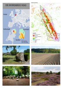
Figure 1. The Hondsrug UNESCO Global Geopark, location and landscape.
The Hondsrug is an area of soft sediment, but large and small erratic boulders, mainly from the Baltics, are widespread on the ridges. Fossils do not occur in situ in the soft sediment, but sometimes they are discovered in the erratic blocks. These ‘hidden fossils’ make the Hondsrug UGG a special case among European Geoparks.
Geological Setting
Geologically the Geopark comprises the Hondsrug-complex, a prominent range of low till ridges in the Saalian landscape in the northeast of the Netherlands (Fig. 2).
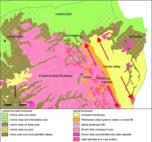
Figure 2. Simplified geological map of the NE Netherlands showing the main landscape units associated with the Saale glaciation. Red arrows indicate NNW–SSE orientation of Hondsrug ridges and Hunze valley. (De Mulder et al. 2003, modified).
The Hondsrug-complex has a NNW-SSE direction, almost perpendicular to the main direction on the Frisian-Drente till plateau (Fig. 3A). The system of ridges and depressions was created in the last phase of the Saalian ice age (140,000 BP) by a combination of sedimentation, deformation and glacial erosion of an ice flow. This Hondsrug ice stream originated in the North Sea region and moved among a mass of "dead ice" over many hundreds of kilometers in a south-eastern direction (Fig. 3B), as far as the Münsterland in Germany (Bos 1990; Bregman & Smit 2012; Meinsen et al. 2011; Winsemann et al. 2004).
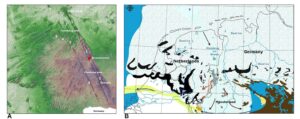
Figure 3. Hondsrug-complex and Hondsrug Icestream. A) Ridges of the Hondsrug compex are interpreted as megaflutes; the direction is almost perpendicular to previous Scandinavian landice movements. Locations: 1, Hondsrug; 2, Ridge of Tynaarlo; 3, Ridge of Rolde; 4, Ridge of Zeyen; 5, Ridge of Norg. B) Late Saalian Hondsrug Icestream. (Pierik 2010, modified).
The depressions between the ridges arose from pressure differences under the ice, pushing glacial material sideways towards the ridges. The relatively fast-moving ice flow caused moraine material, deposited from the sole of the ice, to be simultaneously deformed and eroded. During stagnant phases the ice stream partly melted, depositing a many-meters thick layer of lodgement till in places. Melting out, glacially entrained moraine material was also deposited on top of the underlying gray lodgement till. The intermitting phases of stagnation and flow caused differences in erosion and sedimentation, resulting in a set of ridges that gets wider and higher to the southeast (Berg van der & Beets 1987; Huisman unpublished 1). The parallel, streamlined till ridges of the Hondsrug complex are interpreted as megaflutes (elongate structures caused by fast flow). In Europe, the Hondsrug complex is the only set of megaflutes that was not covered by land ice during the following Weichselian and has therefore been preserved. (Bregman & Smit 2012; Pierik 2010).
The complex of ridges and depressions is about 20 km wide from east to west. From north to south, the length is just over 70 km. The till ridges are at most a few kilometers wide and almost nowhere protrude more than 5 m above the intermediate brook valley plains, but the eastern edge rises some 15 m from the valley.
Till Cover of the Hondsrug Complex
Till is a glacial deposit. It consists of an unsorted mixture of clay, sand, gravel and rocks. Two till types are predominant in the Hondsrug area: an underlying gray till type with above it a red till. Both till deposits lie on a thick substrate of melt water deposits from the Elsterian (Formation of Peelo), deformed throughout the Hondsrug region and intensively thrust in some places during an early phase of the Saalian glaciation. The boulder association in both Hondsrug tills has an East-Baltic composition. Comparing the erratics with bedrock in the Baltics indicates that the majority of glacial material originated from Northern Sweden, the Gulf of Bothnia, southwest Finland and the northeastern Baltic Sea (Zandstra 1974, 1976; Rappol 1984, 1992; Smit 2011). This NNE origin seems to contradict the NWW ice stream but can be explained by the thickness of the inland icesheet in the North Sea at the end of the Saalian glaciation (Huisman, unpublished 1 and 2; Figs. 3, 4A).
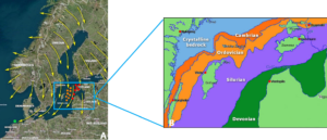
Figure 4. Origin areas of the Hondsrug tills. A) Yellow arrows indicate the direction of land ice movement in the Saalian; orange dots indicate the origin area of the gray till; red dots indicate the origin area of the red till; green dot is the origin area of the Hondsrug Icestream. B) Paleozoic sediments in the Baltic Sea.
Both till types contain Paleozoic limestones (Ordovician, Silurian), found only when the till reaches deeper than 1 m below the surface and especially in the thickest till layers, due to weathering of limestones in shallow and thin till-layers. Both the rock types and the fossils found in the limestones are indicators for the bedrocks they originate from and the age of the erratics (Fig. 4B).
The gray till (Fig. 5A) is the most important and the most widespread till type within the Hondsrug complex. It was deposited from the sole of the Hondsrug ice stream on top of the glacially eroded surface. The gray till contains a great amount of flint from the Late Cretaceous and Danian (Early Tertiary). Some of these flints come from the southern Baltic Sea, some from Lithuania and the surrounding area. The latter consists mostly of black and gray flints, often with a characteristic white cortex. This flint is poor in fossils. Bryozoans do not or hardly appear in it. In addition, the gray till is rich in Paleozoic limestones, dating back to the Ordovician and Silurian. These limestone erratics come from limestone deposits on the bottom of the Baltic Sea, between the Estonian islands of Saarema and Hiiumaa and the Swedish Baltic Sea island of Gotland (Fig. 4B; Jonker 1904; Kruizinga 1918).
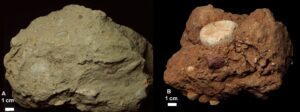
Figure 5. The Hondsrug tills: gray till, Groningen (A) and red till, Groningen (B). The red granite is a Rapakivi granite from the island Aland, Southwest Finland. The white rock above it is a dolomite. (photography, Harry Huisman).
On top of the gray lodgement till lies a second, brown-red till type (Fig. 5B). Within the Hondsrug complex, this red till occurs mainly on the higher parts of the ridges and does not form a continuous deposit. The remarkable color difference is not the only reason why both till types can be easily distinguished. The association of rocks in the red till differs markedly from that of the underlying gray lodgement till. The percentage of Ordovician and Silurian limestone erratics in the red till is remarkably high, in some cases more than 70%. The limestone boulders in the red till are gray, yellow-gray to gray-green. Petrographically, these are very similar to limestone types on the Baltic Sea islands of Saarema, Hiiumaa and Vormsi (Estonia; Fig. 4B).
The red till lacks Cretaceous flint and crystalline and sedimentary rocks from the southern Baltic and southern Sweden. This is an indication that the source of the red till was further east and northeast in the Baltic. The characteristic reddish brown-red color of this till is from the inclusion of sandy and clayey components from the Early Devonian Old Red Sandstone Formation in Estonia, Latvia and on the adjacent Baltic Sea seabed (oral information Prof. L.J.M.U. van Straaten).
Fossils from Ordovician and Silurian Limestones
Paleozoic erratics of limestone are an important component in both Hondsrug tills, and they are rich in invertebrate fossils. In the Ordovician limestones imprints of trilobites (Fig. 6A) and cone-shaped shells of nautiloids like Endoceras (Fig. 6B) can be found. Brachiopods (Fig. 6C), gastropods and calcareous algae are also relatively common fossils. Silurian limestones are extremely rich in fossils like algae, stromatolites, stromatoporoids, bryozoans, brachiopods, gastropods and trilobites. The thicker till layers are especially rich in fossils. They are found accidentally in temporary outcrops for infrastructural works etc.
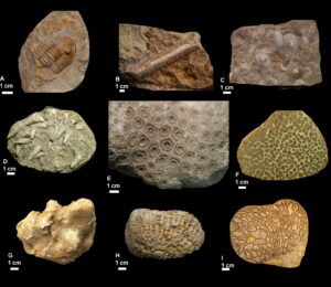
Figure 6. Paleozoic fossils from the erratic blocks. All specimens come from glacial boulders from Groningen, except C which is from Haren. A) Trilobite (Neoasaphus nieszkowskii), Middle-Ordovician. B) Nautiloïd (Endoceras sp.), Lower-Ordovician. C) Brachiopods (Protochonetes striatellus), Silurian Haren. D) Silurian limestone with numerous solitary rugose corals. E) Colonial rugose coral (Acervularia ananas), Silurian. F) Colonial rugose coral (Weissermelia lindstroemi), Silurian. G) Tabulate honeycomb coral (Favosites staringii), Silurian. H) Tabulate coral (Sarcinula organum), Upper-Ordovician. I) Tabulate chain coral (Halysites sp.), Silurian. (photography, Harry Huisman).
A characteristic group of fossils from the red till are Ordovician and Silurian corals, mostly found as loose rock fragments. Over time, many thousands of fossil corals have been found during excavation work on the northern Hondsrug near Groningen and Haren. Nowhere else in Denmark, the North-German lowlands and the Netherlands do erratic Paleozoic corals occur in such numbers. Despite the damage caused to the fossils during transport in the ice, these corals are remarkable. Petrographic and paleontological research in Estonia has made it clear that both limestone and fossil corals in the red till come from the Eastern Baltic, namely Estonia plus islands and adjacent Baltic Sea bottom (Jonker 1904; Kruizinga 1918; Hucke 1967; Schulz 2003; Huisman unpublished 3).
Rugose corals were abundant in Paleozoic shallow seas, especially in the Silurian and Devonian, with both solitary (Fig. 6D) and colony-forming types (Fig, 6E, F). Solitary corals are common in the Hondsrug tills, commonly showing horn-shaped skeleton, with a pointed lower end. Colonial rugose corals were branched like shrubs or formed massive colonies with dense or fused coral tubes on all sides. The corallites have round or polygonal cross-sections and have a characteristic radial structure in cross-section.
Tabulate corals (Fig. 6G, H, I) are dominant in the Hondsrug erratic blocks. Tabulates first appeared in the Ordovician, but reached their heyday in the Silurian, with a second revival in the Middle Devonian. In its simplest form the calcareous skeleton of a tabulate coral consists of a collection of densely packed polygonal tubes (= corallites), each subdivided by numerous horizontal calcareous plates (= tabulae). A striking difference from rugose corals is the small diameter of the corallites, on average no more than 1.5 mm.
Education and Public Activities
The Hondsrug UNESCO Global Geopark aims to provide information and raise awareness to the inhabitants and visitors of the area and to educational institutions through a variety in facilities and activities. Through a thematic approach in so called ‘Expeditions’ the stories are shared with the public. Every expedition has an exhibition in a visitor center, hotspots and trails in the field and a variety of accompanying activities like courses, fieldtrips and lectures. The Hunebedcentrum (Center on hunebeds, i.e. prehistoric megalithic tombs) has a central position in this, with a focus on geology and prehistoric times.
In the Hunebedcentrum a permanent exhibition has been set up about the Pleistocene. Here visitors can get an impression of the ice-age history of the Geopark and its morphology. In addition, the different cultural phases of prehistoric man in the Geopark region are highlighted. The exhibition is supported by instructive and partly interactive presentations about geology, erratic rocks, Pleistocene mammals, prehistoric peoples and their use of materials. The set-up and the provision of information is easy to understand and interesting for young and old.
Next to the center one can find a huge boulder garden, populated by tens of thousands of erratic rocks, large and small. There are dozens of special and rare erratic stones along the paths, provided with information signs. The signs explain name, age and origin of the erratics (Fig. 7A, B). Thus, visitors get an impression of the wealth and variety of erratic stones present in the Hondsrug area and get aware of time and space. With this approach this boulder garden is unique in northwestern Europe.
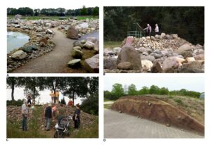
Figure 7. Education and Geotourism at the Hondsrug. A) Part of the Boulder garden at the Hunebedcentrum. B) Overview on the Boulder garden; an information panel explains the influence of the land ice on the landscape and the origins of the erratics in Scandinavia and the Baltics. C) Rock hunting in heaps of stones from arable land near Borger; children and adults may search and take stones from here. D) Hondsruggarden in the former Hortus botanicus in Haren, a reconstruction of the Hondsrug with Weichselian cover sand and Saalian till; illustrated information panels explain the ice-age story. (photography, Harry Huisman and The Hondsrug UGG).
The Hunebedcentrum manages an extensive geological collection, including soil samples, erratic boulders and erratic fossils from the subsoil of the Hondsrug area and comprising several thousand specimens. Temporary exhibitions are put together from the collections, which are exhibited in visitor centers, schools and town halls within the Geopark area. Simple reference collections are compiled on request for primary and secondary education. In addition, the geological expertise of the Hunebedcentrum is engaged to organize ‘boulder-trails’ and provide information elsewhere in the Geopark area, such as in holiday parks and nature areas.
Every winter a nine-day geology course is taught by the curator of the Hunebedcentrum. The course evenings consist of an information part followed by a workshop and is concluded with a fieldtrip. Knowledge about vulcanism, the rock-cycle, landscape formation, ice age deposits, erratic rocks and their fossils is shared in a graphic and accessible way, using the geological collection of the Hunebedcentrum. Participants understand how and where rocks are formed and how they got to the Hondsrug area: a true journey through space and time. The course has been a great success for over ten years.
During the summer holidays a free identification afternoon takes place every month. Children and adults can show their finds, such as stones and fossils, to have them identified and explained by specialists. And once a week the visitors are allowed to search for stones in the Hunebedcentrum depot themselves (Fig. 7C). Supervision and supporting material such as books and identification guides are available then.
Throughout the year, numerous lectures are given on topics related, directly or indirectly, to the history of the Geopark area. The Hunebedcentrum offers a venue for geological associations and study clubs, and the geological collections can be consulted during these meetings. Each year, the Hunebedcentrum organizes one or two meetings on the theme of ice-age geology and erratic rocks. Enthusiasts and interested people come from all over the Netherlands to listen to lectures and workshops by experts.
In the northern part of the Hondsrug, an ice-age garden has been set up in the extensive grounds of the former botanical garden in Haren (Hortus botanicus). With till and cover sand from the immediate vicinity, a terrain with an undulating relief has been shaped, and scattered with erratic rocks. This gives visitors an impression of what the Hondsrug landscape must have looked like in the Ice Age. Next to the ice age garden, a reconstruction has been made of the earth layers in the immediate sub-soil of the Hortus. Visitors get a realistic picture of the soil layers beneath their feet, partly through information panels (Fig. 7D). In connection with this, a small geological exhibition about the geology of the Geopark has been set up in the Hortus visitor center. Leaflets, brochures and boulder guides are also available here.
The history of the people who have inhabited and shaped the area for more than 5000 years is highlighted from different angles and where possible related to the geological origin. To make this visible, walking and cycling routes have been put together for tourists, students and the local population. These routes are supported by maps, brochures and information boards. Guided excursions lead participants through the different landscapes of the Geopark. With virtual reality ancient times can be revived.
Conclusions
The billions of erratics and their hidden fossils in the Hondsrug UNESCO Global Geopark are witnesses of ancient times, environmental conditions and areas abroad. This forms a unique opportunity to connect education and public activities to earth history. With all the described facilities and activities local residents and visitors learn about the special character of their living environment and of the conditions under which this region was formed, offering an imaginary tour through time and space.
Acknowledgments
We thank Dan Grigorescu for his support, suggestions and comments during the writing process, his students for arranging the figures and two anonymous reviewers for their very helpful comments during the review process.