Introduction
Geotouristic itineraries are routes, accessed on foot or through vehicles, which include a set of places that have high scientific, cultural, aesthetic, functional and economic value, among others, and that involve both cultural heritage and geoheritage.
The identification, classification, evaluation, mapping, protection and promotion of cultural and geoheritage add a value to tourism activities (i.e., geotourism) through the interaction between the cultural and natural aspects of the landscape (Panizza and Piacente 2003), being a form of creating interaction between the community and the environment that surrounds it, through the discovery and appreciation of elements in the landscape, until then ignored.
As for the abiotic environment, the geotouristic itineraries are important tools for the dissemination of geosciences because they work as outdoor field classes for teaching about the physical phenomena associated with the landscape. In relation to the cultural environment, it involves the historical record and the characteristics of the geo-resources used in the construction of assets.
Tourism is a secular activity; however, due to its development in recent years, most of it is associated with natural aspects; it has never been highlighted as much as it is today. Rural tourism, ecotourism, adventure tourism and geotourism are some examples of segments that have renewed this activity, increasing incomes, moving capital, improving the quality of life of the populations involved and, when executed in a sustainable way, contributing for the conservation of the environment. This development has created new territories, in which every spatial element that is possible to be inserted into the touristic dynamics is welcomed.
Geotouristic maps blend elements of geoscientific information, related with geodiversity and geoheritage per se, with cultural and tourist features so that the public can easily interpret them.
According to Hose (1995: 17), geotourism is “the provision of interpretative and service facilities to enable tourists to acquire knowledge and understanding of the geology and geomorhplogy of a site [...] beyond the level of mere aesthetic appreciation”. Thus, geotourism works as a mechanism for the development of a sustainable activity, contributing to the geoconservation and dissemination of its geoheritage and cultural heritage. These improve the quality of life of the population, generating funds through the allocation of new values and meanings to the area where it is developed and encouraging the sense of cultural identity by increasing the awareness of the local population and visitors of this heritage.
Geodiversity, as the result of slow evolution since Earth's beginnings, refers to the natural variety of geological (rocks, minerals and fossils), geomorphological (landforms, deposits and processes) and soil elements, including their relationships, correlations, interpretations, systems and properties (Gray 2004). Pedological (soil) and hydrological (surface or subsurface – sweet or salty) diversities are also part of geodiversity; it may be in-situ (in the place of origin) or ex-situ (collected and exposed elsewhere, in the case of rocks and their elements; Ponciano et al. 2011) and may be analyzed at all scales (Serrano and Ruiz Flaño 2007). The human activity plays a fundamental role in interfering with the characteristics of these elements.
Geoheritage can then be described and interpreted in places with relevant aspects, always with the objective of benefiting the local communities and introducing environmental awareness to the elements involved. It refers to the set of values that represent the geodiversity of the territory, composed of abiotic natural elements on the surface (submerged or immersed) that must be preserved due to their heritage value (Rodrigues & Fonseca 2008). It is important to note that, in this work, geoheritage corresponds to the abiotic portion of natural heritage, which can be subdivided into geological, geomorphological, pedological and hydrological heritage.
This work is based on the concept of geotourism like a new segment that aims to appreciate, promote and value the abiotic heritage, or geoheritage, as a whole, including forms and processes (Dowling 2011), adding the abiotic environment to the elements of fauna and flora, while using geoheritage in a sustainable way.
The objective of this work is to propose an itinerary in the southern coast of the Paraiba State. The itinerary includes seven places of geotouristic interest, being two important elements of geodiversity (geological/geomorphological feature of Amor Rock and geomorphological/hydrological feature of ‘Maceió’ of Mucatu) and five geological and geomorphological elements of geoheritage (Tombolo of Coqueirinho, Canyon of Coqueirinho, Cones of Dejection of Coqueirinho, Coqueirinho Structural High and Tambaba Beach). The aim of this proposal is to disseminate the physical aspects of the landscape (geology, geomorphology and hydrology) and the historical-cultural aspects of the assets, in order to contribute for their maintenance and conservation.
It is important to remember that the Paraíba south coast has numerous tourist spots among the most visited in the States. However, the tourism guides exclude, due to the lack of information, the abiotic aspects of the landscape. The proposal of the geotouristic itinerary of this area highlights these aspects, using a comprehensible language since the objective is to communicate with the majority of tourists.
Material and Methods
To obtain the results presented in this work, the following phases were executed, sensu Brilha (2005), namely:
Bibliographic research: in order to know the history, geology, geomorphology, pedology and hydrology of the physical environment of south coast of Paraíba state;
Inventory: the selection of places of interest was based on the presence of values that made them special, such as scientific, aesthetic, cultural, economic and ecologic values. There was the creation of a database with the places, with the completion of descriptive files, containing various information, such as absolute location, means of access, photographic register of the site, a detailed description of geological, geomorphological, pedological and hydrological features, considering the scale of the site, from the outcrop to the landscape (justifying the choice by demarcating the above-mentioned values from nonexistent to exceptional, with a brief description of the geotouristic potential). The threats to the places were considered by analyzing the anthropic and natural ones that make the sites vulnerable, suggesting measures that minimize or avoid them, as well as the existing protection regime.
Quantitative assessment: considers the degree of importance of the element for geotourism, as well as the evaluation of the degree of vulnerability, aiming at the creation of geoconservation measures, based on Pereira et al. 2019;
Promotion: publicity of the value of heritage elements, through the elaboration of this geotouristic itinerary, one of several that will be published later. The position of the sites on the itinerary was related to their geographic location, through a sequential order. Due to the presence of more complete tourist infrastructures, particularly road networks and parking facilities, basic tourist information was prioritized.
The QGIS software version 3.0 (Girona) was used to create the geotouristic itinerary, using the vectorization of the elements of interest from the coverage of the study area. Google Earth image mosaic was used as basis, with the application of the Quick Map Services module. The vector layers used in the elaboration of the maps were applied using the geographical coordinate system DATUM WGS 84 (EPSG 4326 Code).
The geographical scales used in the itineraries varied according to the spatial area of the different maps, so that these could be allocated in their pre-defined layout. The scale of the map was 1: 5,000, being considered as a detailed scale map.
Geological and Geomorphological Context of the Area
The area is located in the topographic chart of João Pessoa (SB-25-YC-3), scale 1:100,000, elaborated by the Army Ministry. The geology of the research area is associated with the Paraíba sedimentary basin. Such sediments were deposited as the South American continent withdrew from the African continent (Françolin & Szatmari 1987), over a crystalline basement deformed by shear zones (Jardim de Sá 1994). This
basin can be subdivided into three sub-basins (Figure 1): Olinda, Alhandra and Miriri. The study area is part of the Alhandra sub-basin, bordered to the north by Itabaiana fault and to the south by Goiana fault.
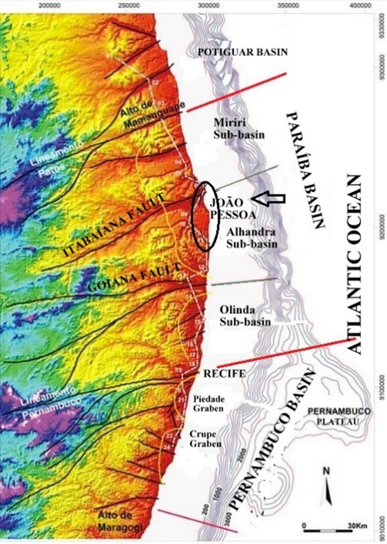
Figure 1. Location Area (circle) in the sedimentary basins of the Northeast. (Source: modified from Barbosa & Lima Filho 2005).
The geological substrate of João Pessoa is marked by sediments that date from the end of the Triassic period to the present (Asmus 1975), on a crystalline basement called
“Terrane Alto Moxotó” (orthogneisses and granite suites) that does not appear in the area. From the sedimentary sequence, we highlight the “Itamaracá”/”Beberibe” Formation (base, siliciclastic), “Gramame”/”Maria Farinha” (center, carbonate) and “Barreiras” (platform cover), as well as quaternary sediments representative of a marine-transitional environment, all of them were modelled and remodelled by exogenous agents, especially fluvial and marine.
From the Pliocene, as a result of the establishment of a stress field in the South American plate, with E-W oriented compression and N-S oriented extension, a series of faults that hit the overlapping sediments were reactivated, having a crucial role in coastal morphology and tracing of the hydrographic network (Bezerra et al. 2001).
The research area belongs to the geomorphologic unit of Plains and Coastal Tablelands, according to Ross (1985), having direct relation with ancient tectonic movements, generated during the drift of the South American and African plates (Asmus 1975), added to Cenozoic tectonic events (Bezerra et al. 2001). We can identify three subunits to the urban site of João Pessoa and the south coast: the coastal plain, low coastal upland (‘Coastal Tablelands’) and floodplains, which can still be subdivided into fluvial and fluvial-marine floodplains (Rodriguez 2002).
The top of the tablelands is linked to the plains in relatively steep slopes, in the form of cliffs, with great scenic beauty, in the shore. The coastal lowlands are in direct contact with the sea, having altitudes between 0 and 10 m. Quaternary sedimentation of river, marine and rivermarine origin filled the coastal plain, resulting in numerous geomorphological features that can be considered potential geomorphosites for its scenic beauty and/or relevant geological/geomorphological history. On the margin of the Paraiba River, floodplains occur on higher altitudes, whose presence of mangroves, away up to 12 km of the coastline denote its ecological importance. In the northern portion of the study area, the sandbank of Cabedelo (“Restinga de Cabedelo”) separates the Paraíba River from the Atlantic Ocean. The low coastal uplands, also known as “Coastal Tablelands”, correspond to a higher, gently sloped portion of the land, with flat top, generally inclined to the east, result from the action of exogenous agents that carved the
Barreiras Formation, including marine abrasion on cliffs. Most of the urban site of João Pessoa sits on this geomorphological unit.
According to Brito Neves et al. (2004), these low coastal uplands, subordinated to paleoclimate, resulted from large arching and a succession of steeped pediplains to inland, whose graben-horst-type structure controlled its morphology. Reactivation of basement shear zones with E–W ansd NE–SW direction, from the Early Cretaceous (Nóbrega et al. 2005), affected the sediments of the Barreiras Formation, forming fault scarps that are capped by alluvial terraces, sandstone dunes, debris slopes, soil and vegetation, and serving as bounds of the river valleys, while the upraised portions were dissected (Lima et al. 1990).
Thus, the altimetric quotes of the urban compartment of tablelands show uplifted portions (west, whose elevations reach 70 m) and lowered portions (between Mumbaba River and Sanhauá River, a tributary of the Rio Paraiba, where altitudes do not exceed 40 m), rising again (in the upper course of the Rio Cuiá), decreasing toward the east, and denoting the structural behavior of the graben-horst type, bounded by normal faults (Bezerra et al. 2001). The substrate of municipality is represented by a Graben, called “Gráben da Grande João Pessoa”, according to Brito Neves et al. (2004), whose sediments reach 300 m thick when they reach the basement.
Figure 2 shows the geological and geomorphological map of the area.
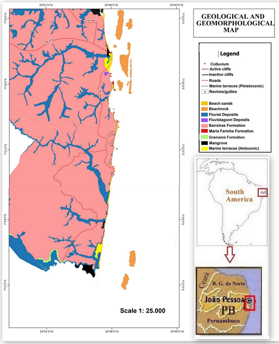
Figure 2 . Geological and geomorphological map of the área.
Results: Proposed Geotourism Itinerary
The proposal involves a geotouristic itinerary consisting of seven places of interest: Amor Rock, Tombolo of Coqueirinho, Canyon of Coqueirinho, Cones of Dejection of Coqueirinho, Coqueirinho Structural High, Tambaba Beach and ‘Maceió’ of Mucatu, according to Figure 3.
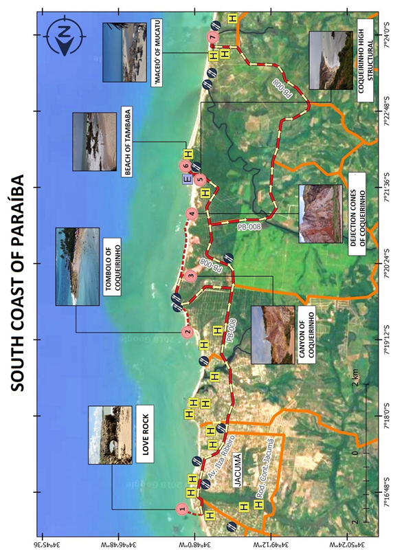
Figure 3. Geotourist itinerary in the South Coast of Paraíba State.
1st stop: Amor Rock
The Place of Interest is located at the northern limit of Jacumã Beach, bordering Amor Beach and close to the mouth of the Guruji River (Figure 3), which belongs to the homonymous basin.
The Guruji River, as well as its tributaries, deeply carve the sediments of the Barreiras and post-Barreiras Formation, generating sides with high slopes, but which do not reach underlying layers, with predominantly W-NW towards the main river, E -NE for the left margin and W-SW for the right margin, showing symmetry. This notch is more accentuated in the tributaries of the right bank, which have their sources in the Coqueirinho Structural High(Stop number 5), reaching a declivity of 100%, as is the case of Riacho Pau Ferro and Caboclo (Furrier 2007; Barbosa 2013; Furrier & Barbosa 2015). At the mouth, the abrupt change in the direction of displacement denotes structural causes. Thus, this place of interest consists of one of the rare outcrops of the Maria Farinha Formation on the coast of Paraíba, presenting three pertinent aspects of assessment, each with its own values: the cavity formed by marine abrasion, the pavement of alveolar lapias (Figure 4a) and the outcrop itself, which has tectonic causes.
Amor Rock is also known as Pierce Rock, due to its shape. The cultural value of this element of geodiversity, in its geomythological aspect, is reinforced by the local folklore that states that a single person, when passing through this cavity, ends up finding a soul mate. Furthermore, since the 17th century this feature has appeared on maps, following the example of João Teixeira Albernaz (1640).
Amor Rock is surrounded by a pavement of alveolar lapias, similar to other beaches where this formation occurs, such as Tambaba Beach (Stop number 6), denoting its geomorphological importance, as a feature of limestone dissolution.
The place of interest can also be classified as a geological asset in its structural aspect, since the limestone outcrop at Jacumã Beach is a consequence of the uplift of the land, which can be corroborated by the abrupt change of direction of the Guruji River, at the rear, until then E-W, for S-N, forming a 'elbow', and flows a few meters north of the site, in the form of a 'maceió' (Figure 4b).
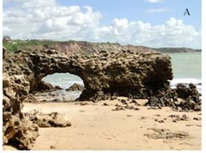
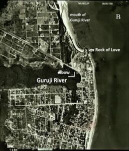
Figure 4 - Elements of geodiversity at Stop number 1. A) Amor Rock, with its field of adjacent alveolar lapias. Photo: Leandro Marcon; B) 'elbow' of the Guruji River, generated by the uplift of the land that caused the limestone to appear on the beach. Photograph: Foto: INCRA/Terrafoto (1998).
2nd stop: Tombolo of Coqueirinho
Coqueirinho Beach (Figure 3), easily accessible by the PB-008 road, is the main tourist destination on the south coast, according to IFEP (2014). With a length of about 5 km, it is the most extensive in the research area, and can be divided into two parts: to the north, with about 3300 meters, it is relatively straight (or with two very open inlets), with the highest cliffs of the state in the rearguard, presenting features of continental erosion, as colluvial and talus deposits; to the south it consists of three inlets, giving a crenulated aspect to the coast when seen on a smaller scale, separated by rocky spits, formed mainly by Maria Farinha Formation limestones. These spits have a fundamental role in the formation of the tombolo (Figure 5). The restaurants and bars are located between the two parts.
The spit is formed by limestones from the Maria Farinha Formation (base) and ferruginous sandstones from the Barreiras Formation (top). They are responsible for the generation of shadow zones that accentuate the deposition of sediments, widening the beach at its rearguard and forming the tombolo, while updrift the effect of diffraction accentuates erosion, narrowing the beach, but leaving the waters calmer, being an excellent place for swimming. Completing the landscape, it has inactive cliffs with vegetation that beautifies it even more.
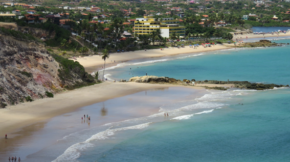
Figure 5. View of the inlet of Coqueirinho and, in the foreground the tombolo, from the rocks that form the spur, with calm waters at the rearguard and inactive cliffs in the distance. Photo: Luciano S. Pereira
The outcropping limestone, of reef origin, has a set of joints, with the main E-W direction and normal and transcurrent faults with a clockwise slip, visible through iron oxide veins. In thin section, its composition is 95% calcite crystals and 5% pores, having no apparent bioclast or portions of matrix or some other allochemical grain, however there is possible “ghosts” of the same (skeleton-like shapes of some bioclasts, Figure 6A) and some empty spaces that resemble bioclast molds (Figure 6b). The rock can be classified as a Recrystallized Biomicrite (sensu Folk 1962), since the calcites that today form the total of this thin section have a stained appearance, typical of matrix recrystallization or Recrystallized Mudstone (Dunham 1962). As there are no other elements for a more accurate analysis of diagenetic events, they can be interpreted in chronological order: as a Mesodiagenesis event, the recrystallization of the matrix and hallochemicals (transformation of bioclasts formed by aragonite into calcite and the matrix into calcite), dissolution of constituents (bioclasts generating mold pores and intraparticle porosity) and dolomitization.
Even though it is inserted in the Tambaba APA (Environmental Preservation Area), monitoring of buildings and visitors in relation to environmental impacts on the beach, biodiversity and the surrounding cliffs is minimal. The subdivision of areas for the construction of parking lots causes deforestation which, therefore, intensifies the erosive effects, causing a series of problems. The outcrops of ferruginous and limestone sandstones suffer from trampling and marine abrasion, accentuating their destruction.
Figure 6 - Thin section of the limestone of the Maria Farinha Formation at Coqueirinho Beach. a) Bioclast phantom in the center of the photomicrograph. b) Mold porosity (?) evidenced in the rock. In both, parallel nicols. Photos: Luciano S. Pereira.
3th stop: Canyon of Coqueirinho
The most imposing gullies of the area are located at Coqueirinho beach and the largest gully is mostly known as 'Coqueirinho Canyon'. The access is through Coqueirinho Beach (Figure 3). It is possible to enter with an automotive vehicle, but it is suggested that you park at the entrance and continue on foot.
Its exceptional scenic beauty has made it a must-see tourist spot at the south coast. These gullies, in the rainy season, form small streams that pour tons of sediment into the ocean, forming cones of dejection. Considering that the gullies are active landforms, the instability of this feature threatens roads and affects the productivity of soils, harming the agriculture.
The gullies formation process is associated with superficial water erosion, which causes the initial formation of deep and narrow ravines that, not contained, evolve to larger gullies (Cunha 1991).
The Coqueirinho gully has asymmetrical slopes, with declivities higher than 100%, length of about 1 km, width of 160 meters, depth of 40 meters and a main axis in the S-W – N-E direction. Subsequently, smaller ravines were formed, currently evolving (Figure 7a), perpendicular to the larger gully.
The geological substrate on which the gully was developed is extremely diverse. It ranges from fine to coarse sandstones and claystone / sandstone, with flat-parallel stratification to conglomerates. The presence of a facies showing thinner clay layers, interspersed with thicker sandy layers, with bioturbation structures (icnofossils, Figure 7B), may indicate tidal cycles, which confirm the marine origin of the formation or a mixture environment of salty and sweet waters, like an estuary. They also present tilting and faults in various directions (Figure 7c) and folding, which combines with the structural activity of their formation, in addition to numerous isolated conical shapes, one of them popularly known as ‘Castelinho’ (Little Castle), which can be seen from a viewpoint at the top of the tableland, a must-see point for those taking a buggy trip along the south coast.
According to Furrier (2007), these gullies developed as a consequence of an accelerated headland retreat, of extremely rapid evolution, with a strong carving of the adjacent tablelands, due to the uplift of the land that gave rise to the Coqueirinho Structural High (Stop number 5). The anthropic action contributed to the intensification of the process, with the deforestation at the top of the tablelands, for the construction of buildings and roads, added to the intense rains in the winter period.
Balsamo et al. (2013), studying the iron impregnations in the gully, identified normal and reversed faults from several directions, but with a predominance of SE-NW oriented faults, which affect only the Barreiras Formation, not reaching the upper deposits.
Locally, poorly litified sandstone facies occur impregnated with diffuse hematite with centimeter to metric extensions, usually associated with fault zones (Figure 7d). These iron impregnations are a consequence of the percolation of fluids rich in Fe+2 along the fault plane, which were mixed with O2-rich water from the groundwater. Thus, diffusion of O2 occurred in the Fe+2 solution, precipitating hematite nodules (Balsamo et al. 2013).
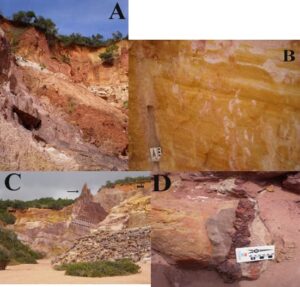
Figure 7. Structures and textures in the rocks of Coqueirinho Canyon. A) View of the southern tip of the gull, with its limits showing the process of erosion in activity; B) Intercalation of sand and clay, with plane-parallel stratification and an ichnofossil record (left); C) Tilting of the layers of the Barreiras Formation, with the soil superimposed without deformation. The arrow indicates one of the existing isolated cones (‘fairy chimney’); d) Centimetric impregnation of iron in sandstone. Photos: Luciano S. Pereira.
4th stop: Cones of dejection of Coqueirinho
It is located at Coqueirinho Beach, south sector, easily accessible by the PB-008 road (Figure 3), characterized by features of continental erosion, markedly large cones of dejection, ravines and gullies. However, on a smaller scale, it is possible to observe associations with neotectonic movements, such as extension faults and percolation by hematite, forming the 'Liesegang rings / bands'.
The cones of dejection are found at the foot of the Barreiras Formation cliffs, on colluvial deposits that prevent marine abrasion and make it possible to classify the cliffs as inactive (Figure 8). They are predominantly sandy to poorly sorted conglomerates, witnesses of a period of water deficit.
Their altitudes vary between 10 and 20 m, with the surface slightly inclined towards the coastal plain. Debris flows are the predominant type of mass movement.
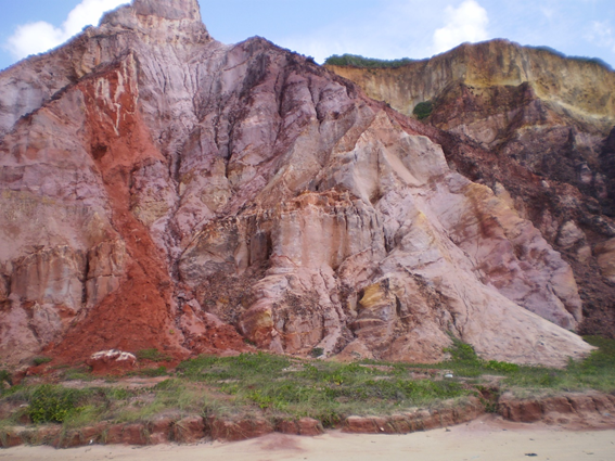
Figure 8. Cones of dejection in Coqueirinho Beach. Photo: Luciano S. Pereira.
Bittencourt et al. (1983) suggest that these deposits were prior to the Penultimate Transgression since, in other areas of the northeastern coast, the Pleistocene marine terraces touch these deposits and were the last to suffer erosion.
In the Plio-Pleistocene sediments of the Barreiras Formation, some interesting and even didactic features deserve to be highlighted: low-angle tabular cross-stratification, neotectonic deformation structures (extension faults with centimetric fault throw) and ‘Liesegang rings / bands’.
Low-angle tabular cross-stratification is the structure of one of the several sedimentary facies of the Barreiras Formation (Figure 9A). In this case, medium sandstones with a reddish gray color were distinguished, well sorted and a matrix composed of millimeter grains of quartz and K-feldspar. They form layers of 3 to 4 meters laterally continuous thickness. These characteristics suggest that they were deposited in a beach environment, such as a styrenium and tidal influence zone. Brittle deformation structures, such as extensional microfails with centimetric slips and fault plans filled with iron oxide, are important tools for proving the action of neotectonic events.
The 'Liesegang Rings / Bands' are significant indicators of the mobility of solutes (Fe2+ and O2) in groundwater, which mix physically, mainly controlled by the porosity of the embedding rock and its brittle nature, with the precipitation of iron oxide, especially hematite, as impregnations, concretions and masses of minerals ranging from millimeters to meters (Balsamo et al. 2013). The geometry of these deposits developed within the vadose zone along faults in direct relation to the Coqueirinho Structural High (5th stop) and the smooth folds associated with it. The geometry of the 'rings' can be laminar ('bands') or concentric ('rings', Figure 9 B & C), both deformed by transcurrent faults, with millimetric slips and consisting of an intercalation of rich and depleted layers of iron oxide.
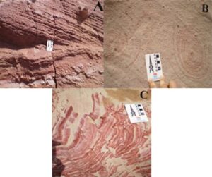
Figure 9. Structures present in the rocks of Cones of Dejection of Coqueirinho. A) Low-angle tabular cross-stratification. You can see normal microfaults with millimeter slip cutting through the layers; B) Liesegang ‘rings’ with concentric shape; C) tabular 'Liesegang bands', showing intercalated layers rich and poor in hematite, cut by transcurrent faults with centimetric slips. Photos: Luciano S. Pereira.
5th stop: Coqueirinho Structural High
The Place of Interest is located 130 meters from the Tambaba Beach “entrance” (Figure 3), corresponding to a panoramic view of part of the structural high (Figure 10), the beaches of Tambaba and Coqueirinho and the associated rocky outcrops (Barreiras sandstones and Maria Farinha limestones).
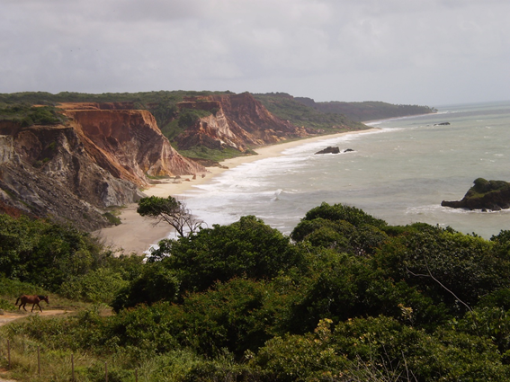
Figure 10. Panoramic view of part of Coqueirinho Structural High. Photo: Luciano S. Pereira.
Furrier et al. (2006) and Furrier (2007) analyzed the behavior of the hydrographic network between Gramame River and Graú River by means of orbital images, topographic and geological maps, aerial photographs, drilling of tubular wells and fieldwork, associating it to the relief of coastal tablelands, in an area that almost covers the south coast of Paraíba.
About Gramame River, the authors concluded that its valley is limited to two distinct morphosculptural units. At north, the behavior of the tablelands is of more extensive surfaces and lower altitudes than the southern portion, with rivers aligned according to a SSE-NNW trend directly influenced by faults in the same direction. However, this lesser extent network carves the sedimentary formations of the Paraíba Group, since the limestone of the Gramame Formation arises occasionally in the valleys of the Miriri and Paraíba rivers. The variation in the height of the tablelands shows uplift and lowering of the terrane, with the highest altitudes south of the Miriri River (122-177 m) and the lowest between the Paraíba River and the Gramame River, where João Pessoa is located (49-77 m).
South of the Gramame River, on the other hand, presents the relief most dissected by the drainage network, where the tablelands do not extend over a very large area and the altitudes are higher, reaching 210 m. They have tops with a poorly developed semi-convex shape, different from the tabular shape of the northernmost area. The layout of some rivers changes their direction sharply, such as the Gramame, Graú and Mucatu Rivers, as result of the uplift of part of the terrane, where the limestone of the Gramame Formation arises on the right bank of the river, while on the left bank it is only found in wells tubular at about 20 m depth. At Coqueirinho Beach are found the highest cliffs in the State, with 40 m height. However, they are inactive cliffs, in some areas covered by vegetation and with evidence of continental erosive processes, such as solifluxion, landslides, debris flows (4th stop) and mud flows, among others, resulting from a process of accentuated dissection of the terrane.
The behavior of south hydrographic networks of the Rio Gramame basin, with its drainage patterns strongly influenced by structural control, with extremely embedded valleys, the intense exhumation of the underlying layers, the high declivity of the slopes, combined with the outcrop of the Maria Farinha Formation on the beach and the nearshore (up to 1 km from the coastline) and the high dissection rate of the terrane, generating geomorphological features in the tablelands like hills, with very small surfaces, are consequences of the uplift of the terrane through a feature called Coqueirinho Structural High, proposed by Furrier et al. (2006). The presence of limestones in the nearshore serves as fixers of algae colonies, which denotes the high ecological values of the Structural High.
This horst, which acts as a watershed that limits the Guruji River Basin, to the north, from the Graú River Basin, to the south, with altitudes above 120 m and E-W direction, was selected as a Place of Interest, being the Tambaba Beach viewpoint the ideal place to view part of these features (Figure 10) that corroborate the existence of the structural high.
6th stop: Tambaba Beach
The place of interest corresponds to an extensive area that extends along Tambaba Beach (Figure 3), with access through the PB-008 road, including the main inlet where are located the parking lots and tourist infrastructure (non-naturist sector). With about 130 meters length, the adjoining north inlet, up to 30 meters, has access through trails that enter the forest. Another adjoining inlet, to the south (naturist sector), about 250 meters long, is separated by two small reef limestone promontories and the southernmost, a rectilinear beach, extends for another 910 meters (Figure 11).
Several geological, geomorphological and cultural aspects are highlighted: fundamental importance for the Tabajara ethnic group; is located the first and most famous nudist beach in the Brazilian Northeast Region; corresponds to the southern limit of the outcrop of Maria Farinha Formation limestones, fossilized and with dissolution features, in addition to forming natural pools in the low tides, of great aesthetic beauty; at the rearguard, inactive cliffs, with colluvial deposits at the base, present characteristics of continental erosion (gullies and forested debris flow) and features of neotectonic activity (folding).
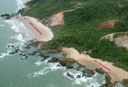
Figure 11. Aerial view of Tambaba Beach. Photo: Ricardo Paulo.
This beach was considered a sacred place for the Tabajara Indians where, in a remote past, they buried their dead. There is an outcrop of the Maria Farinha limestone, with a coconut tree at the top, located on the foreshore-nearshore limit (Figure 12A), which has a spiritual meaning for this ethnic group because they relates the ancestors with the spirits of the waters and forests (Farias & Barcellos 2014), denoting the cultural value, in its spiritual bias, of this element of geodiversity. The beach has an infrastructure of bars, surrounded by vegetation and with an inactive forested cliff at the base, at the rearguard. In the main inlet, the limestones outcrops on the beach form beautiful natural pools at quadrature tides (Figure 12B).
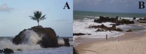
Figure 12. Geoheritage elements in Tambaba Beach. A) Outcrop of limestone with the coconut tree symbol of Tabajara spirituality; B) Tambaba beach natural pools. Photos: the author.
These deposits of reef limestones can be classified, according to Folk (1962), into calcilutites, calcarenites, laminites and limestone with a coquinoid aspect, with bivalves and gastropods molds (Figure 13). Arranged in a chaotic way, they present a secondary porosity, consequence of the dissolution of the shells. This faciological variation can be found in vertical profiles of a few meters and denote beach, interreef, lagoon and reef deposition environments, respectively.
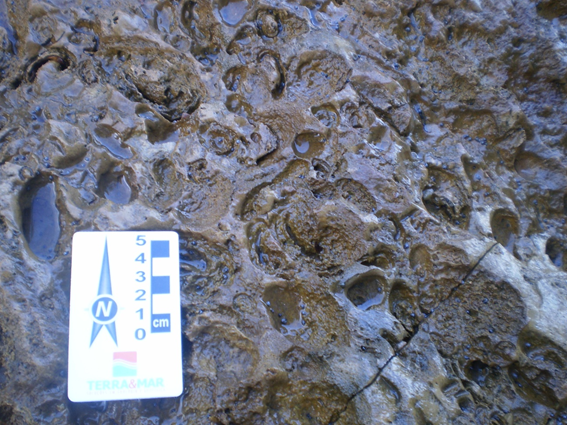
Figure 13. Macroscopic appearance of reef limestones with a coquinoid aspect, forming a cemented floor abundant in shells of bivalves, rhodoliths and gastropods. Photo: Luciano S. Pereira.
Correia Filho (2014) made a thin layer of coquinoidal limestones, due to its paleontological importance and its greater representativeness in the area. This rock, according to Folk (1962), was classified as a bioesparite (or 'mudstone', according to Dunham 1962), originally cemented with micrite and recrystallized by spastic calcite (Figure 14a).
The siliciclastic contribution is minimal, restricted to a few grains of quartz and fine K-feldspar, which presupposes that the deposition took place on a restricted platform, which hindered the influx of sediments. The presence of dolomite euhedral crystals with up to 10 μm shows a process of dolomitization. These crystals have recrystallized edges by calcite cement, in a late form, which characterizes a process of de-dolomitization, showing different diagenetic processes. The rock, with signs of oxidation (consequence of the meteorization process) and phosphating, has fragments of recrystallized or dissolved bivalve and gastropod shells, and tubes of excavator organisms, with oxidized walls as bioclasts (Figure 14B).
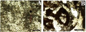
Figure 14. Thin section of Maria Farinha Formation limestone at Tambaba Beach. A) Matrix originally micritic and recrystallized by spastic calcite. Detail for transversal section of tube produced by vermiform organism, with agglutination of crystals on the wall (red arrow). Parallel nichols. Photo: Correia Filho (2014, p. 48); B) In the central portion of the photo, a gastropod fragment. Crossed nichols. Photo: Correia Filho (2014, p. 51).
To the north of the main inlet, trails that enter the promontory go towards small beaches. The outcropping limestones, located on these paths between the Atlantic Forest and the beach, are richly fossilized with algalic rhodoliths, belonging to the genus Archeolithothanium sp (Figure 15A) and with numerous dissolution features such as alveolar lapias (Figure 15B). These lapias are consequence of the formation of microfractures with secondary organic action (lichens, algae, mosses and roots, according to Rodrigues et al. 2007).
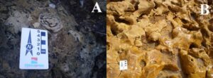
Figure 15. Maria Farinha limestones on Tambaba beach. A) Limestone rhodoliths of the Maria Farinha Formation; B) Detail of alveolar lapiás. Photos: Luciano S. Pereira. Photos: Luciano S. Pereira.
From this beach, at its southern end, there is access, through a trail in the Atlantic Forest, to a new and more extensive inlet, where is located the Tambaba Naturist Beach. The Associação Tambaba Nua (‘Naked Tambaba Association’) was created in 1991, based on Municipal Decree nº 276, authorizes the practice of naturism as a norm for access to the beach, being the first nudist beach in the Northeast.
In 2002, State Decree nº 22882 was issued, giving origin to the Tambaba State Environmental Preservation Area (APA). According to information from the employees, the beach, in high season (December to February) can receive 200 tourists per day. To the rearguard, an inactive cliff about 30 meters high shows continental erosion.
The existence of the naturist sector, therefore, is a consequence of the geography of the inlet, isolated by two forested promontories, with a cliff in the rearguard, which justifies the high functional value of the site. Further south of the naturist sector, about 800 meters, the base of the cliffs has forested colluvial deposits, at the rearguard of a berm line that protects it from marine abrasion. Almost at the end of the beach, before reaching a Holocenic marine terrace that marks the beginning of Grau beach, a cliff presents folded rocks (of the syncline type), which corroborates the existence of neotectonism. On a larger scale, it can be seen that its layers are cut by extensional and strike-slip faults, with slipping smaller than 80 cm. ts exceptional aesthetic value, combined with the very high cultural and functional values, make the area an important example of the geoheritage of the coast of Paraíba.
7th stop: ‘Maceió’ of Mucatu
Access to the ‘maceió’ is from the PB-008 road, towards the municipality of Pitimbu (Figure 3). The area is well signposted. ‘Maceió’ is a regional term for a lagoon fluvium deposit that mixes hydrological and geomorphological elements. It is characterized by the isolation of the Mucatu River, which flows into a relatively meander intertidal plain, where the marine deposition of the coastal cord and the river action form a small lagoon (Figure 16). In the high tides, the laggon is connected to the sea.
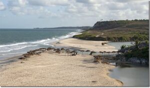
Figure 16.‘Maceió’ of Mucatu. Photo: Luciano S Pereira.
The lagoon fluvium deposit is rich in organic matter, with sand and clay sedimentation. These deposits “are found: i) in the drainage network that was installed over the Pleistocene marine terraces during the regression subsequent to the Penultimate Transgression and that was later drowned during the Last Transgression; ii) in the low zones that separate the Pleistocene from the Holocene terraces and; iii) at the bottom of the valleys exhumed in the Barreiras Formation” (Bittencourt et al. 1983: 94). They were deposited in old lagoons formed in the final phase of the Last Transgression and, later, were isolated in the subsequent regression, eventually evolving into swamps, whose wood was dated, at the mouth of São Francisco (2 samples), in Aracaju and Lagoa Olhos D'água (PE), by the C-14 method, resulting, respectively, in ages of 5.75 ± 200 ka BP (sample 1) and 5.415 ± 95 ka BP (sample 2).
Holocenic terraces correspond to sandy deposits, with no more than 4 m above the current high tide level, which were formed during the marine regression following the Last Transgression (Bittencourt et al. 1979) or Santos Transgression (Suguio and Martin, 1978 ), between 5 and 7 Ka AP (Martin et al. 1979), according to studies on the quaternary deposition of the coast between Rio de Janeiro and the State of Alagoas. On these terraces the current human activities in the region are developed.
A 17th century map was found in the internet (http://www.obaudemacau.com/?s=Ilha+de+Manoel+Gon%C3%A7alves) called ‘Capitaniarium de Phernambuca, Itamaraca, Paraiba et Rio Grande Noua delineatio’, of unknown origin, all in Latin (Figure 17A), where the Mucatu River and its ‘maceió’ were mapped with the name ‘Icatu’ (Figure 17b), an important coastal feature, or at least curious for the navigators of the time, which highlights its cultural value. It should be noted that, on the same map, in the vicinity of Amor Rock (1st stop), the author identifies a river named Mucatu. However, due to its location, it is the Bucatu River.
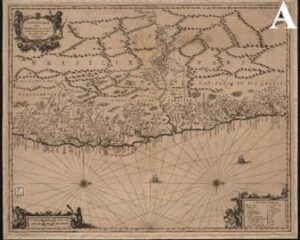
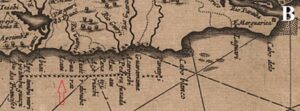
Figure 17. Maceió of Mucatu River and 17th century iconography. A) Map, by unknown author, with the location of Maceió of Mucatu River; B) Detail of the previous map. Source: www.obaudemacau.com/?s=Ilha+de+Manoel+Gon%C3%A7alves website
Discussions
The south coast of Paraíba State has been conslidated as a mass tourism destination for decades, focused on ‘sun, sea and sand’ tourism, but without a connection, systematization or even an interpretation to properly exploring its geoheritage importance.
For example, every day, dozens of buggies depart for the south coast taking eager tourists for landscape appreciation, but at the return ride, eight hours later, with the mind and camera full of gorgeous images, they do not have any scientific understanding of how this landscape connects to the Earth’s formation. With this, one realizes the importance of mapping the sites of the area that, when inserted into a geotouristic route designed to be covered in one or two days - a weekend, for example, result in the disclosure of this basin’s geodiversity and geosciences as a whole, adding value to tourism, generating direct and indirect jobs, boosting the economy and promoting other positive consequences, without forgetting that, in the end, the sites’ geoconservation must be the main focus.
Thus, if the role of geotourism is promoting geodiversity and its geoheritage through sites of geotouristic value, it is necessary to implement projects with scientific, educational and interpretive purposes. The alliance between public-private partners is necessary in order to minimize conflicts, solve problems and deploy processes that enable the insertion of geotourist activity in the study area and the popularization of the term.
Although this is not the scope of this project, it is suggested that in order to maximize the effectiveness of such a process, common goals be agreed upon and the respective shares of responsibility of the government and academia be fulfilled through a collaborative alliance, thus resulting in legitimate policy decisions. These goals are:
i) Conscientization of the local population - from the people who live or work near the inventoried places to students and teachers at all levels, managers, community leaders, local businesses, among others, all must be aware of the importance of the inclusion of this activity in their daily life;
ii) Training and education of labor that will work directly with geotouristic activities. In this case, it is proposed that all those interested in this activity should be properly registered for later specialized training through short courses in related agencies such as the National Service for Commercial Education (SENAC) and Brazilian Service to Support Micro and Small Enterprises (SEBRAE);
iii) Adequacy of tourism infrastructure, either interpretive or as transport infrastructure. In the case of geointerpretation, it is crucial to distribute maps, pamphlets, folders, brochures, etc., to tourist agencies and the installation of panels and banners on places that are part of geotouristic route. In the long run, audiovisual resources, interpretive programs, museums and other entities can be implemented in areas where geotourism is present. In this context, it is important to pre-define the rules for transport to and enjoyment of certain isolated places, such as mangroves forests, sandbanks and reefs, for example, to minimize the degradation of the natural environment.
The academia must contribute in providing favorable means for the geotourist activity to develop, the mapping of geoheritage of the area, with its inventory and evaluation, and elaboration of the Geotouristic Guide, so that geointerpretation, an essential component of geotourism, can be prepared and used by planners.
After all, geotourism combines leisure and geoscientific-cultural education, enabling the valuation and generation of new attractions aimed at geoheritage. Enjoying the landscape and understanding its physical characteristics should be part of geotouristic activities.
Conclusions
The role of geotourism is to bring the public closer to the geoheritage and the cultural heritage of the area visited, through geointerpretation strategies designed for the public that visits it. Thus, the interaction with the abiotic environment will sensitize the tourist/geo-tourist to perceive it from a new point of view and to promote geodiversity and geoheritage. This interaction will also serve as a tool for the education of the local population and tourists and disseminate geosciences beyond classrooms, with the purpose of preserving and managing this geoheritage and associated cultural heritage.
The main geoproduct obtained from the mapping of the places of interest was the geotouristic map, with its itinerary. Its interdisciplinary character and geoeducational material play the role of the awareness creator and sensitizer towards the geo-conservation and the promotion of the geoheritage.
The geointerpretation has a fundamental role in the transcription of the geological information of the terrane to instigate the public who, until then, only appreciates the landscape from an aesthetic point of view. Thus, it is crucial to know the profile of the public that visits the areas in which they intend to insert geotourism activities, in order to adapt the strategies of geointerpretation and dissemination of geohereitage After all, transforming the arid, and sometimes indigestible, geoscientific nomenclature into something palatable to the lay public is not an easy task.
The holistic vision allowed a range of new interdisciplinary discussions to be open, by enabling cultural experiences distinct from traditional ones and by rediscovering its cultural roots, a sense of place and a reverence for the natural world, achieved through the recognition and celebration of the creativity associated with the abiotic heritage.
If the natural landscape and its geo-features have served as an inspiration for literature and arts since the beginning, today, they are tools of scientific studies, restricting the comprehension of an audience larger than that of the academic world. Thus, it was also sought, through this analysis of correlation between the physical environment and the cultural environment, to rediscover a sense of geo-awareness through the aesthetic appeal that this landscape instils and its importance to society.
The 'sun and sea' is the main tourist attraction of the region, allied in a secondary level to a rich history and culture that neglects the latent geotouristic potential. The geotouristic itineraries also serve to promote geotourism as an asset, inserting in the traditional tourist context information about the previously forgotten abiotic environment. Therefore, mass tourism will be promoted for a niche tourism, becoming more sustainable under the environmental bias.
This article aims at putting into practice, as a final product, a geotouristic itinerary in the south coast of Paraíba State. It proposes a promoter of the abiotic environment, a trigger for the development of a geo-conservationist awareness and a facilitator of the local economy, necessary for the role that the abiotic environment has as a record of current and past geo-environments, influenced by various elements and influencer of many others. In addition, the geotouristic itinerary can be used not only for tourist purposes, but also for educational ones, and all the information presented is a way of promoting the geoheritage to the local communities and tourists.