Introduction
Concern with the planet's future has been the object of several actions worldwide. In 2015, the United Nations presented the 17 Sustainable Development Goals (SDGs), which consist of action plans to help member countries deal with the development of their economies, the ending of poverty, the protection of the environment and climate, and the maintenance of peace. The document is subdivided into 169 targets that should guide both public policies and actions by private institutions in achieving the 17 SDGs.
As geosciences deal directly with the understanding of Earth's history and materials, as well as the past and present processes that continuously shape the globe, they may play a key role in the achievement of the SDGs. Gill (2017) points out 12 ways in which geology can contribute to sustainable development, including access to drinking water, energy supply, mining, geotourism and geoeducation, which strengthen the relevance of the earth sciences to society (Cordani 2000; Larwood et al. 2013; Prosser et al. 2013). As emphasized by Stewart (2016) and Stewart and Gill (2017), the social role of geosciences requires that geoscientists become aware of their essential and fundamental role in sustainable development.
In this context, geoconservation is a branch of geosciences that may integrate geoscientific knowledge by the definition and protection of relevant sites with their promotion and sustainable use by society (Sharples 2002; Henriques et al. 2011; Prosser et al. 2013). Implementing effective geoconservation strategies can, therefore, bring significant benefits and expand the vision that permeates nature conservation, integrating bio- and geodiversity. From this perspective, geoconservation should be an essential part of society's future planning, because many SDGs can be linked to geodiversity (Gordon et al. 2018; Stephens 2020). Brilha (2017) points out that, among these 17 objectives, several are directly related to geoconservation, which can encourage interested researchers to join efforts to define integrative geoconservation strategies at various levels. Gill (2017) places geological heritage and geotourism as themes in the geological sciences related to the 17 SDGs.
As basic units of geoconservation (Henriques et al. 2011), geosites are well-defined places in which the elements of geodiversity are valuable as records of significant events in Earth's history. The set of geosites in a region makes up its geological heritage (Brilha 2016), and they are selected from inventories of candidate sites that represent places of geological materials and processes. Along with other places of interest, geosites are the object of actions related to territorial planning and management. In a broader sense, including these elements is essential to achieve a more comprehensive approach to nature conservation.
The north coast of the state of São Paulo, Brazil, has been the focus of studies and actions in geoconservation since 2011 (Garcia et al. 2019a). Among these studies are systematic inventories that define geological sites that vary, in terms of size and geometry, from single points to areas or sections and are representative examples of lithostratigraphic units, structures, landforms and processes of both internal and external dynamics that act and acted in the region (Prochoroff 2014; Santos 2014; Reverte and Garcia 2016; Arruda et al. 2017; Garcia 2019; Garcia et al. 2019a, and references within).
Here, we aim to evaluate the geosites inventoried on the north coast of São Paulo, Brazil, regarding their potential role in the implementation of the 17 SDGs and 169 targets in the region. Furthermore, this approach aims to contribute to public policies that include geodiversity as support in promoting the SDGs.
Study Area
The north coast of São Paulo comprises the municipalities of Ubatuba, Caraguatatuba, São Sebastião, and Ilhabela. The current physical configuration of the region arises from a combination of geological, geomorphological and climatic factors active since the Archean, including the amalgamation of the Western Gondwana Supercontinent (Neoproterozoic), the opening of the South Atlantic Ocean (Jurassic–Cretaceous), the formation of the Serra do Mar mountain range (Late Cretaceous–Paleogene) and variations in sea level (Quaternary). These processes gave rise to a profuse geodiversity, an attractive scenario for geotourism and scientific dissemination activities, and a rich cultural heritage.
Inventories of geological sites performed in the region indicated 87 sites, including 43 geosites and 44 geodiversity sites (Garcia et al. 2019a), in the sense of Brilha (2016). These places constitute the bases for several geoconservation initiatives that include the dissemination of geological knowledge, such as an interactive geotourism map guide (https://geohereditas.igc.usp.br/mapas-e-roteiros-mistos/, accessed on 23/11/22). Figure 1 presents the location map of the 43 geosites.
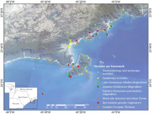
Figure 1. Map of the northern coast of São Paulo, with the location of the 43 geosites distributed in eight frameworks, coded by color. Source: Garcia et al. (2019a).
Methodological Procedures
The analysis of the geosites according to the SDGs was carried out according to the following steps:
- Systematization of geosites according to the values of geodiversity. The 43 geosites previously inventoried in the area were qualitatively evaluated according to their main values using Gray’s (2004) proposal as intrinsic, cultural, aesthetic, economic, functional, didactic and scientific. This preliminary evaluation was used as a reference to outline the main interests of each site.
- Classification of the geosites according to their Essential Geodiversity Variables (EGV) (Schrodt et al. 2019). In this step, the sites were categorized according to the classification of resources and processes on the Earth's surface. The authors established eight EGVs subdivided into four classes (Table 1).
Table 1. Classification of the Essential Geodiversity Variables by Schrodt et al. (2019).
Class | Essential Geodiversity Variables |
Geology | Hardrock, fossil and mineral distribution |
Unconsolidated deposits | |
Geophysical processes | |
Geomorphology | Landform distribution |
Soil | Chemistry |
Physical state | |
Hydrology | Surface water |
Groundwater |
- Definition of the 17 Sustainable Development Goals and 169 targets that can benefit from the use of each geosite. As each SDG has a variable number of goals, a relative percentage for each of the 17 SDG was calculated according to the following formula:
Relative percentage per SDG = (Total of targets verified in the area * 100)/ Total of targets defined in the UN agenda
- Integration of the data. In this step each geosite was analyzed according to the associated values and the selected EGVs in the light of the 17 SDGs and 169 targets. Information on each site regarding its characteristics and potential uses was obtained with the use of data from previous geoheritage inventories (e.g., Prochoroff 2014; Santos 2014; Reverte and Garcia 2016; Arruda et al. 2017; Garcia 2019; Garcia et al. 2019a).
Results
Essential Geodiversity Variables (EGV)
From the eight subclasses of EGVs defined by Schrodt et al. (2019), three were identified on the north coast of the state of São Paulo: Hard rock, Fossil and mineral distribution, Unconsolidated deposits, and Landform distribution. Some geosites can be placed in more than one category; in these cases, only the most representative characteristic of each geosite was considered.
The subclass "Hard rock, Fossil and mineral distribution'' represents the distribution of natural resources in a selected area. Most of the geosites on the north coast of São Paulo are included in this subclass, which includes many geodiversity elements. As examples are the geosites representing the region's lithotypes, such as the Metatexitic Paragneisses and Amphibolites of Boiçucanga (Fig. 2A), and sites showing geological structures, such as the Mylonites and Cataclasites of the Camburu Shear Zone, which was associated with the amalgamation of the supercontinent Gondwana in the Neoproterozoic.
The subclass "Unconsolidated deposits" represents the sedimentary dynamics of the study area. Several geosites may be included in this class. The geosite Pleistocene Marine Terraces of Praia Vermelha do Norte stands out as an excellent paleoenvironmental marker where it is possible to visualize the marine terrace with native vegetation (Fig. 2B). The subclass "Landform distribution", whose focus is essentially geomorphological, aggregates the places that present landforms generated by erosive processes. In this category, the geosite Pico do Baepi is a landform composed of rocks representing an 80 Ma alkaline magmatism, which stands out in the landscape among Precambrian metamorphic rocks (Fig. 2C). In addition to its unique geomorphological features, the place can be reached through an ecotourism trail and acts as a viewpoint from which it is possible to observe the Serra do Mar Mountain range, the coastal plain and the Atlantic Ocean.
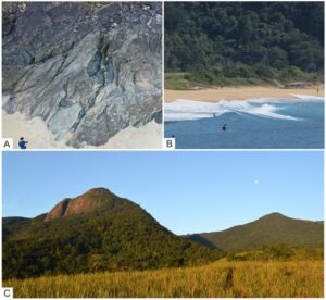
Figure 2. A) Geosite "Metatexitic Paragneisses and Amphibolites of Boiçucanga", in São Sebastião, showing boudinaged and folded amphibolitic bodies; B) Geosite "Pleistocene Marine Terrace of Praia Vermelha do Norte", in Ubatuba, with emphasis on the marine terrace with vegetation transitioning from the coastal plain to the Atlantic Forest biome; C) Geosite "Pico do Baepi", in Ilhabela, an important tourism attraction in the region. Photo B: Fernanda Reverte.
The Geosites and the 17 SDG and 169 targets: Connections
One of the goals of SDG 1 (No poverty) is to build the resilience of people with less economic power by combating and reducing their exposure to situations of vulnerability. In this sense, geosites are essential in that their designation involves the verification and analysis of the vulnerability of a territory. Further, among the interests linked to geosites is their association with environments of the past, knowledge of which can be essential in predicting and mitigating climate change.
According to CATI (2015), approximately 125 rural properties in Ubatuba are classed as family farming, a common scenario on the north coast of São Paulo. In this sense, SDG 2 (Zero hunger), by focusing on assessing the best places for implementing family farming, can benefit from research related to geodiversity. Identifying and evaluating geosites can contribute to the choice of the best locations for family agriculture by identifying areas with fertile soils.
SDG 3 (Good health and well-being) relates to actions that involve people's health and well-being. The geosites can act directly by helping to identify areas without pollution. Moreover, many of these sites are in unmodified natural environments, encouraging their use for various sports, such as ecotourism trails (Guimarães et al. 2022).
The role of SDG 4 (Quality education) in promoting scientific research and geoscience studies, topics directly linked to geosites as geological heritage, can also be identified in the study area. The Centre for Research Support on Geological Heritage and Geotourism (GeoHereditas) installed interpretative panels that show information about the geological history of the region in a didactic and accessible way (Fig. 3A). Other examples are ecotourism trails in the protected areas, socio-educational practices to raise environmental awareness.
SDG 5 (Gender equality) works on gender equality by empowering women through education programs. On the north coast of São Paulo, this SDG is promoted on several fronts, such as training courses for tourism guides and environmental monitors (Garcia et al. 2019b), helping to improve the insertion of women in the labor market (Fig. 3B).
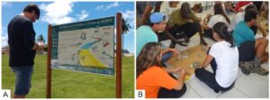
Figure 3. A) Interpretive panel located on the north coast of São Paulo, part of a set of 12 panels that, together, tell the geological history of the region; B) Training geosciences course for environmental guides at the Serra do Mar State Park. These courses comprise both conceptual and practical activities with the aim of disseminating geoscientific knowledge to be transmitted to park visitors.
Issues related to water quality are addressed in SDG 6 (Clear water and sanitation), and geosites can help to guide the planning and the management of the territory. Inventories of geological sites can help decision-makers by using geoscientific knowledge to assist in the development of actions for protection and restoration of water-related ecosystems, such as mountains, forests, wetlands, rivers, aquifers and lakes.
Job growth is included in SDG 8 (Decent work and economic growth). In this regard, the geosites can generate new jobs related to geotourism and sustainable tourism. In addition, geodiversity conservation actions can help economic growth by reducing environmental degradation and providing new jobs linked to sustainability, as well as in transport infrastructure, hotels and restaurants for the tourists.
SDG 10 (Reduced inequalities) seeks to reduce inequalities, including targets for small producers' work and local communities' awareness. In the study area, geosites can help to achieve this SDG by promoting the protection of geological heritage used by small producers, and by raising awareness of the importance of local traditional communities, including the caiçaras, quilombolas and indigenous peoples (Arruda 2017).
In SDG 11 (Sustainable cities and communities), the inventory of geosites assists in urban planning by contributing to the understanding of locations and constraints of the physical environment, in addition to identifying regions with water potential to serve cities efficiently.
SDG 12 (Responsible consumption and production) has goals on sustainable management and efficient use of natural resources, sustainable development and implementation of tools for sustainable tourism, generating new jobs and promoting local culture and products. The interactive geotourism map prepared for the northern coast of São Paulo acts in this SDG by offering new locations as alternatives for sustainable tourism, showing a decentralization of tourism in the region using a geological approach.
Records of the 1967’s Catastrophe of Caraguatatuba (Fig. 4A) works to promote SDG 13 (Climate action) by representing areas susceptible to natural disasters of a geotechnical nature. The inventory of geosites also helps in building resilience to natural disasters and designing actions to improve education and increase environmental and climate awareness.
As a coastal area, SDG 14 (Life below water) is exemplified in the geosites as a means to reduce marine pollution and protect coastal ecosystems through encouragement of sustainable tourism. The geosite Dykes of Ponta do Araçá is an example where important geoheritage is directly related to a mangrove ecosystem and fishing communities (Fig. 4B). Moreover, as natural barriers to coastal erosion, sand beaches and mangroves should have special protection measures, which can be implemented with the help of geoconservation.
SDG 15 (Life on land) is facilitated by geosite geoconservation actions as they promote the sustainable use of terrestrial ecosystems, reducing biodiversity loss. The Atlantic Forest, an important Brazilian biome, develops on soils formed from granitic and gneissic rocks from Serra do Mar, emphasizing the relationship between bio- and geodiversity. In addition, it involves raising awareness and increasing education about sustainability.
Figure 4. A) Geosite "Records of the 1967's Catastrophe of Caraguatatuba", in the homonymous town. The pebble deposits on the bank and the poorly sorted boulders along the river's course record landslides that were responsible for a great disaster in the town; B) Geosite "Dykes of Ponta do Araçá", in São Sebastião. The rocky shores (lower left) are composed of both alkaline and basaltic dikes related to the breakup of Gondwana that constitute important geoheritage. The bay sustains a mangrove ecosystem that provides habitats for several species and benefits local communities.
Discussion
The maintenance of contemporary society demands the consumption and use of natural resources. Against this backdrop, the 2030 Agenda seeks to alert and propose actions to minimize environmental, social and economic problems. In implementing the SDGs, the participation of societies and, mainly, governments with the offer of public policies is necessary. Since geodiversity is related to sustaining life and the provision of natural resources, actions aimed at the conservation of geodiversity and geoheritage can act as facilitators in promoting the SDGs.
Geodiversity is negatively impacted on the north coast of São Paulo mainly by human actions. The region presents recent urbanization related to mass tourism, expansion of productive processes and real estate speculation (Gallo-Junior et al. 2011). The lack of planning integrated with conservation and enhancement of the abiotic portion of the physical environment harms the supply of goods and services provided by geodiversity in the region (Balaguer et al. 2022). Further, the places where traditional peoples live are particularly affected by increasing urbanization. Thus, the environment's degradation is accelerating, which can impact the geological heritage and biodiversity.
In considering the role of geodiversity and geological heritage in implementing the SDGs, we had to characterize and assess these elements. As representatives of the region's geological diversity, the analysis of geosites can be extrapolated beyond their limits and, in a broader perspective, to the composition of ecosystems.
Categorizing geosites through the EGVs (Schrodt et al. 2019) was essential to assemble an overview of how each geological site could act in public policies. According to Reverte (2020), it is crucial to use well-defined variables to propose an appropriate management mechanism for each context. This categorization is important as it helps researchers to identify geodiversity elements and to develop actions to monitor geosites.
The combination of data obtained from the analysis of both EGVs and geodiversity values added to the information on each site taken from previous geoheritage inventories indicated that, from the 17 SDGs, 13 can be potentially related to the use of the geosites in the context of geoconservation (Fig. 5).
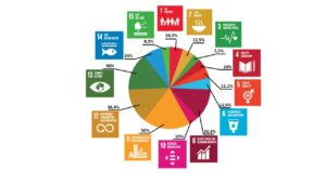
Figure 5. Percentage of targets associated with each SDG whose achievement can be facilitated by actions involving geosites on the north coast of São Paulo.
SDG 11, 13 and 12 have the highest percentage of targets that can benefit from actions involving geosites (50%, 40% and 36.4%, respectively). These SDGs are associated with offering sites to promote sustainable initiatives and production and indicating actions that minimize climate change. As an abiotic component of nature, geodiversity research can help to indicate the most suitable places for the installation of cities and agricultural production, in addition to providing natural elements as resources (for example, metallic minerals and construction materials) and acting in climate maintenance.
SDGs 3, 15, 4 and 10 have the lowest number of targets that can be associated with geosites (7.7%, 8.3%, 10% and 10%, respectively). Among these targets, however, there are important themes, as in the case of SDG 4, in which we identified only target 4.7, which deals with ensuring the acquisition of knowledge and skills necessary to promote sustainable development through education. Implementing public policies to achieve the SDGs is, therefore, independent of the number of targets.
According to Gordon et al. (2018), some key conservation policy areas indicate ways to integrate geoconservation into the broader nature conservation agenda. Examples include contributing to natural capital, valuing ecosystem services, promoting ecosystem management, and achieving Sustainable Development Goals. As Rosado-González et al. (2020) discuss, the contribution of geopark territories in promoting the SDGs and identifying that some SDGs are more beneficial than others, and we identified a direct relationship between the inventoried geosites and 13 of the SDGs. However, the other four SDGs can benefit indirectly from the actions undertaken at geosites to achieve the other SDGs.
Conclusions
The integrative approach of our results indicates that the geosites of the north coast of the state of São Paulo are potentially related to the promotion of 13 SDGs: 1) No poverty; 2) Zero hunger; 3) Good health and well-being; 4) Quality education; 5) Gender equality; 6) Clear water and sanitation; 8) Decent work and economic growth; 10) Reduced inequalities; 11) Sustainable cities and communities; 12) Responsible consumption and production; 13) Climate action; 14) Life below water and 15) Life on land.
This work shows preliminary results on the potential use of the geological heritage of the north coast of São Paulo, Brazil in implementing the 17 SDGs. Further, the results corroborate the abiotic environment's fundamental role in defining actions and public policies associated with these themes and bringing critical perspectives into an ecosystems approach.
From a broader perspective, geoconservation as a multidisciplinary branch of geosciences has much to offer in geodiversity studies and the definition, conservation and promotion of geological sites. Moreover, our work could be taken further with studies of the ecosystem services provided by geodiversity, and understanding how the abiotic part of nature contributes to life on Earth can help in actions that help in the implementation of the SDGs.
In this context, our results can help provide an incentive for the geoscientific community to deal with environmental, social and economic issues. Thus, they can encourage greater participation of the local community and involvement of public authorities with an ability to influence public policies for nature conservation, education and tourism with the sustainable use of geodiversity.
Acknowledgments
M.G.M.G. thanks the National Council for Scientific and Technological Development (CNPq), grant 314689/2021-4.
Conflict of Interest
The authors declare no competing interests.