Introduction
Geotourism is referred to as a form of tourism that focuses on the geosystem in a natural area (Gray 2011; Newsome & Dowling 2010). An early definition of geotourism as strictly ‘geological tourism’ was published by Hose (1995, 2000) and has subsequently been refined as a form of tourism that specifically focuses on geology and landscape. Nowadays, geotourism is developing at a very rapid rate around the world and will become an essential touristic activity in Thailand (Singtuen & Won-In 2017, 2018a, b). The Satun Geopark of Thailand is certified as the first UNESCO Global Geopark of Thailand and the fifth Global Geopark of Southeast Asia by the UNESCO in 2018. Thailand Geopark (http://www.dmr.go.th/ThailandGeopark) focuses to impel this Pha Chan – Sam Phan Bok Geopark as the UNESCO Global Geopark in the future (Fig. 1). This geopark has many geoheritage sites that were linked with history, nature, and culture of Thai people, so it deserves to be an aspiring global geopark. For example, the prehistoric painting in Pha Taem Cliff is the most famous cliff in Thailand. The life style of local people also linked with Mekong and Mun Rivers which are the causes of many geosites including rapid, pothole, river beach and also a cascade.
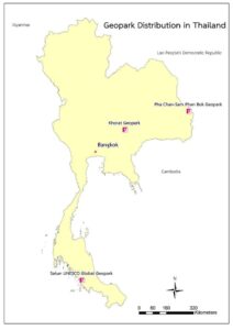
Figure 1 Geopark distribution in Thailand
Moreover, geological heritage or geoheritage was defined as the feature of a geological nature, it emphasizes on geodiversity including landform, rock, mineral, fossil, structure, sedimentary sequences, and other resources. Furthermore, it contained a high scientific value and combined with educational, cultural, and aesthetic value that also justify their necessary use by society (GSA 2012; Santos et al. 2016; Brilha 2016; Nemeth et al. 2017; Moufti & Nemeth 2017). In addition, the excellent management of geotourism can be a useful tool for sustainable development in both the local and national community (Newsome et al. 2012). Migoń et al. (2017) described the conservation and geotourism perspectives at Granite Geoheritage Sites of Waldviertel, Austria, which inspired geoconservation promoting in the current study. It described the selected sites of significant geoheritage value, reviewing their appearance, geological background, and the provisions for tourism.
Pha Chan - Sam Phan Bok Geopark is at Ubon Ratchathani Province, which is located at the northeastern part on the border between Laos and Thailand. It is a rural province of rice paddies, small villages and Mekong River populations made of Laotian and Thai-Lao ethnicities. At Khong Chiam District of Ubon Ratchathani Province, the Mun River is the most important river for agriculture and electricity producing of the Khorat Plateau and joins with the Mekong. It is called Maenam Song Si (two-color river) or the Mun River alluvium as the brown water from Mekong River is mixed with blue water from Mun River. There are features cascades and ancient cliff paintings in the Pha Taem National Park, which is located close to the border. This area is dominated by outcrops of sedimentary rocks that are parts of the Khorat Group. The Khorat Group is made up of various Upper Mesozoic sedimentary rocks such as massive sandstone, siltstone, claystone, conglomerate, etc. (Fig. 2).
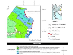
Figure 2 Location and a Geologic map of selected study case in the upper part of Ubon Ratchathani Province, Thailand (modified from DMR 2007)
The richness of sedimentary structures (i.e., cross-bedding) and geomorphological features of the Khorat Group in Ubon Ratchathani Province provide (Fig. 2) very scenic traits to the local landscape such as Mekong River panoramic view along the 3 kilometers trail in Pha Taem Cliff. Moreover, it have been promoted by the tourism industry as the major natural asset to the region. The outstanding and diverse geoheritage sites related to the Khorat Plateau including the rocks themselves but also the unusual landforms and the Austro-Asiatic human use is appreciated locally since 4,000 years ago (Kijngam 1994). However, these geoheritage sites are poorly known internationally, despite their diversity and accessibility. While spectacular landforms occur in various places in the Khorat Plateau, those in Northeastern Thailand (i.e., Ubon Ratchathani) stand out in many ways and deserve more publicity. Most impressive and interesting among the features of these sedimentary rock landscapes are potholes, rapids, stacks, cliffs, and cascades, which are reasons to establish the Pha Chan - Sam Phan Bok Geopark in this area. Nevertheless, the local network including local administrations, community representatives, schools, local businesses, and NGOs is the most powerful to engage in geoconservation (Brilha & Reynard 2017).
Therefore, this research landscapes, aimed to provide the first description of geotourism in this geopark and its development for the travel industry. Each location selected in this study may be considered as a potential geoheritage site as they differ in the degree of development for geotourism. The scientific data of the geoheritage site are also valuable for the tourist industry, as they help to promote travel plans and lead to good economy of this region. As geotourism is part of a recent announcement of targeting by the Thai government, additional revenue can be obtained.
General Geology
The Pha Chan - Sam Phan Bok Geopark lies in the easternmost margin of the Khorat Plateau in Ubon Ratchathani Province, Thailand. These sites are located along the Mekong River and the Thai-Lao border. The Mekong River flows in a north-south direction through China and Myanmar and is offset by the Nam Ma Fault in Cenozoic (Lacassin et al. 1998). It leads the river to flow in a SSW direction into the Mae Sai basin until it changes direction to the east, possibly caused by the left-lateral, strike-slip Mae Chan Fault (Bait et al. 1997; Fenton et al. 1997; Kosuwan et al. 1998). The Mekong River flows to the southeast and marks the border between Thailand and the Lao People’s Democratic Republic. The sites can be divided into three principal localities; Kaeng Tana National Park (Mun River watershed), Pha Taem National Park (Thai Mekong downstream), and Pha Chan Area (Thai Mekong upstream). The studied region covers five formations of the Khorat Group including Phra Wihan Fm., Sao Khua Fm., Phu Phan Fm., Khok Kruat Fm. and Maha Sarakham Fm. (Fig. 3). These formations are described from older to younger as follows: The Phra Wihan Formation comprises of well sorted, rounded, fine-coarse grained, pale yellow sandstone, thin-bedded siltstone, mudstone, and conglomerate. Thick sandstone beds of the high cliff in this formation were deposited in a braided stream environment, whereas thinner sandstone beds were deposited in meandering rivers (Meesook 2000). Intercalations of siltstone and mudstone are normally found in the sandstone beds, which show little resistance and is reduced to small hills. Palynomorphs include Cyathidites sp., Classopollis sp., Ballosporites hians, Lycopodiacidites sp., Calamospora sp., Monosuleites sp., Ballosporites sp., Cyclotriletes subgranulatus MADL, Minutosaccus sp., Chasmatosporites sp., and Anulatizonites, which are indicating a Late Triassic to Early Jurassic age which is as old as pollen in the Phu Kradung Formation (Hahn 1982). The Sao Khua Formation consists of cyclic sequences of reddish-brown sandy mudstone with interbedded siltstone, fine to medium grained sandstone and conglomerate. Sand and gravels were deposited in meandering rivers and swamps on the river bank in semi-arid paleoclimate (Meesook 2000). In addition, Kon’no and Asama (1973) found plant remains of Sphenoptheris goeppati, which is dated from Late Jurassic to Early Cretaceous.
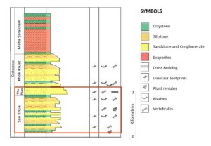
Figure 3 The upper part of a composite stratigraphic column of the Mesozoic rocks of the Khorat Plateau, NE Thailand that are distributed in the study area )Modified from Morley et al. 2011)
The Phu Phan Formation consists of medium to coarse-grained light grey sandstone. Some sandstones grade into thick beds of a conglomerate with large planar and trough cross-bedding. Pebbles consist of white quartz, grey and green volcanic rocks, and grey, dark grey, reddish brown, black light grey and green chert. Detrital grains are well rounded but poorly sorted. In some areas, lenses of dark grey shale are found interbedded. The Phu Phan Formation was deposited in braided streams and meandering rivers at hot and humid to the semi-arid environment (Meesook 2000). Since the Phu Phan Formation overlies the Early Cretaceous Sao Khua Formation and underlies the Khok Kruat Formation of the same age, then the age of the Phu Phan Formation should be Early Cretaceous. However, the palynomorphs confirmed the age of the Phu Phan formation that Early Cretaceous age (Racey et al. 1994, 1996).
The Khok Kruat Formation comprises reddish brown, reddish purple sandstone, siltstone, mudstone, and conglomerate. Some sandstone beds contain pebbles of reddish-brown siltstone, claystone, and some quartz. Calcrete nodules and caliche occur at the top of some mudstones. Gypsum lens and laminated interbeds of sandstone and siltstone also occur. The Khok Kruat Formation was deposited in a meandering river system, and Paleoclimate changed from semi-arid at the beginning to arid at the end (Meesook 2000). Red sandstone of the Khok Kruat Formation at Nam Phung dam, Sakon Nakhon province contains the freshwater bivalves Plicatotrigonioides subovalis Kobayashi, Pseudohyaia sp., Nippononaia carinate Kobayashi, Niotononaia (Mechongichoncha) subyuadrata Kobayashi, Nippononaia (Mechongi-choncha) robusta Kobayashi, Plicatounio namphungensis, and Unio sampanoides, dated as Early to Middle Cretaceous (Sattayarak et al. 1991).
The Maha Sarakham Formation comprises interbedded claystone, siltstone, and rock salts. Based on data obtained from exploration of potash deposit and petroleum, it is suggested that this formation should not be included in Khorat Group (Sattayarak, 1983, 1985). The Maha Sarakham Formation was formed by deposition in salty lakes and ponds in an arid climate (Meesook, 2000). Pleomorphic studies indicated the age of the Maha Sarakham Formation is Cenomanian (Sattayarak et al. 1991).
Materials and Methods
The materials of this research comprised many kinds of a comprehensive literature review about geotourism and related to the study area and also the topographic map of the study area (scale 1:50000), and the geologic map of Ubon Ratchathani Province (scale 1:1,000,000), were studied for fieldwork planning. Moreover, the fieldwork is equipped by many geologist’s tools for geoheritage investigating such as a geologic hammer, compass, field notes, measuring tape, GPS, and camera. Then geoheriatge sites were inventoried and mapped based on the previous listing from Thailand Geopark and their potential in the field. The selected geoheritage sites are the famous and stunning geologic landforms of Thailand. These sites have their identity, representative, well-known as well as also suitable for tourism and learning. The characterization of geoheriatge sites was carried out by observations and description of the geoscientific knowledge and tourism information. Furthermore, a strategic planning technique was used to identify strengths, weaknesses, opportunities, and threats for geoconservation and geotourism development in the study area.
Geoheritage Sites and Geoconservation
Ubon Ratchathani is located in the easternmost part of Thailand and far from Bangkok approximately 630 kilometers (Fig. 1). The tourists can drive to the eastern flank of this region and pass through many remarkable geological attractions, which are located near the Mekong River . The geoheritage sites of the Pha Chan - Sam Phan Bok Geopark are distributed in three areas from the south to the north including Kaeng Tana National Park, Pha Taem National Park, and Pha Chan Area (Fig. 4).
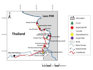
Figure 4 Location, general morphology and accessibility of geosites in the upper part of Ubon Ratchathani Province, Thailand
Kaeng Tana National Park
The Kaeng Tana Nature Park is the most advertised location in Ubon Ratchathani where water rapids are present. The area is located on the eastern flank of the town and covers approximately 80 square kilometers of deciduous forest, pothole river landform, cascade, and river bank. The topography is highland and drained by the Mun and Khong Rivers. The average elevation is about 200 meters, and the highest peak stands at 543 meters. The Kaeng Tana is the largest pothole river landform found in the Mun River. In the middle of this landform, there is a huge sandstone boulder splitting the river into two streams, and a concrete block was built during the French colonial era to identify a channel for cruising. The Don Tana is the most attractive deposit of sediment into an island located in the middle of the Mun River. It is 450 meters wide and 700 meters long (Fig. 5A). Namtok Rak Sai is cascade in the northern zone of the park, while Namtok Tat Ton is a cascade in the southern part (Fig. 5B). They are on the same Highway 2173. When the stream runs over resistant bedrock, erosion occurs slowly and is dominated by impacts of water-borne sediment on the rock, while downstream, the erosion occurs more rapidly as the water flow increases its velocity at the edge of the waterfall, it may pluck material from the riverbed when the bed is fractured or otherwise more erodibility. The stream sometimes flows over a giant step in the rocks that may be fault related.
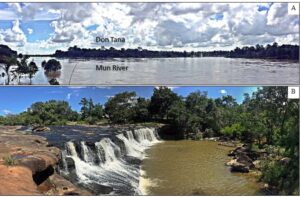
Figure 5 A) Don Tana middle the Mun River and B) Tad Ton Cascade
The Kaeng Tana National Park is on the Mun River (DNP, 2015). It was established on 13th of July 1981 and is an International Union for Conservation of Nature and Natural Resources (IUCN) Category II (National Park) protected area (Wikramanayake, 2002). National parks are legal forms of both geosite and natural site protection to conserve landscapes for significant aesthetic value. Within the landscape protected area, the most impressive rapids such as Kaeng Tana are listed as nature monuments because they have many natural values from botany and zoology points of view, so they should be investigated in the future. A difficulty remains in the erosion and weathering trend of sedimentary rocks that will eventually cause damage to geosites such as Kaeng Tana (Pothole River) landform and Don Tana following variable flow rate in the Mun River. High volume of water causes turbulent flow, which can lead to the destruction of both geosites.
Due to the Kaeng Tana National Park is proximity to the Ubon Ratchathani, it is developed as an outdoor recreation ground. There are many facilities including a suspension bridge, viewing point, outdoor court, and accommodation. In the northern part of the area, the Namtok Rak Sai Nature trail follows the cliff by the Mun River, 500 meters from the park headquarters. This trail is a route along the cliff for 1 km and through forests that consists of various kinds of flora, such as lichens, mosses, and ferns. The geosites are easy accessibility. However, there is not a lot of information available about the geosite description and interpretation of the landforms and the origin of rock formations on site such as geologic panels, geologic museum, and geotrails. The park can be visited through year-round, except during rainy season (June-September) because of a massive water volume flood.
Pha Taem National Park
The Pha Taem Nature Park is the best-promoted locality for touristic purpose in Ubon Ratchathani where cliffs (Fig. 6A) and twin stacks are present (Fig. 6B). Plateaus and hills dominate the park landscape. There are many factors to form the cliff such as fault displacement and the resistance of rock. These sandstone cliffs, form in strongly cemented sandstones, especially on the sides of deep valleys and around the edges of the plateau (Fig. 6C). There are many sedimentary structures such as cross-bedding, honeycomb weathering (Fig. 6D) and polygonal cracking (Fig. 5E). The surface of the cliff has many prehistoric rock arts, which are dated back to 3,000-4,000 years ago and discovered by Kijngam (1994) and known in Pha Taem, Pha Kham, and Pha Mon Noi areas (Fig. 7A-C). These paintings illustrated the lifestyle of ancient human such as fishing, rice farming, people, animals and geometric designs that show the way of life during the prehistoric time and reflect the ancient lifestyle of the people who lived there.
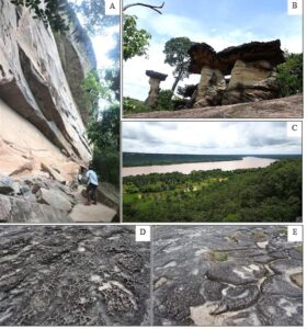
Figure 6 A) Pha Taem Cliff, B) Mushroom rocks, C) Mekong panoramic viewpoint, D) Honeycomb weathering, and E) polygonal cracking
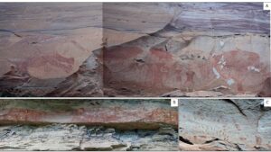
Figure 7 The prehistoric cliff paintings on the Pha Taem cliff; A) Pha Taem, B) Pha Kham, and C) Pha Mon Noi
Prehistoric men painted on harder beds of sedimentary rocks such as medium-coarse sandstone. There is a good selection of geologic materials such a rock board for the creation and permanence of these paintings. In contrast, work done on soft beds such as shale and siltstone is easily weathered, and preservation is not optimal.
There are several examples of mushroom rocks (twin stack/pillars) which is the largest mushroom rock in Thailand. The twin stacks are formed by in situ weathering and erosion by wind and water in the past. Variable resistance of rock beds causes a different degree of weathering. In the north of this National Park, Pha Chana Dai is the easternmost point and therefore the first place in Thailand to be seen the first rays of sunrise above the Mekong River. At dawn, a sea of mists floats over the riparian side of the Mekong River. The tourists can enjoy nature, flora, mountain, and Mekong River. Dong Na Tham Forest is the most interesting nature site in this park where is covered by Dipterocarp forest, which consists of Shorea obtusa, Shorea siamensis and Dipterocarpus obtusifollus as dominant species (Chuaynkern et al. 2009). The park is a habitat for Siamese hares, barking deer, civets, palm civets, wild pigs, and serow, which migrate from Laos in summer. The specimens of a new frog species, Fejervarya triora, were discovered in the park in 2005 (Chuaynkern et al. 2009). On the way from the park headquarters to the Pha Chana Dai, a good dirt road leads to many cascades such as Soi Sawan Cascade, Saeng Chan/ Long Ru Cascade, and Thung Na Mueang Cascade from south to north (Fig. 8). The Soi Sawan Cascade is a large perennial cascade originating from 2 main creeks before merging with the Mekong River. The Thung Na Mueang Cascade is a medium cascade flowing straight off a high and cliff to a creek below. The Saeng Chan/ Long Ru Cascade is a unique feature as it flows through a mountain tunnel to a pool below. The water hits against the tunnel reminding of the moonlight against the earth surface.
Pha Taem National Park is along the Mekong River in Ubon Ratchathani Province of Isan region, Thailand (DNP, 2015). This park is the famous tourist site of Ubon Ratchathani, so it has many legal structures to ensure site protection and sustainability of harmonious cultural landscapes of significant aesthetic values. (http://park.dnp.go.th/visitor/nationparkshow.php?PTA_CODE=1073). Within the landscape protected area, the impressive sediment cliff of Pha Taem also as strict protection rules regarding the prehistoric rock paintings, and other sites are listed as nature monuments. As these cliffs are the result of the Cenozoic left-lateral, strike-slip
faulting along Mekong River (Bait et al. 1997; Fenton et al. 1997; Kosuwan et al. 1998), collapse is possible along joints of N65E direction. Many geotechnical attempts have been made to grout these joints for geoconservation. However, biological weathering issues cannot be repaired as trees put down roots through joints and cracks in the rock. As the tree grows, the roots gradually split the rock apart and can be a threat of this geosite. In addition, turbulence in the Mekong River during the rainy season can also erode this area in the park.
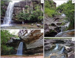
Figure 8 A) and B) Soi Sawan Cascade, C) Saeng Chan/ Long Ru Cascade, and D) Thung Na Mueang Cascade
The Pha Taem National Park is a local nature attraction, advertised as a site of interest and easy to reach. A graded field road leads to an undeveloped parking lot and information panels (Fig. 9). Due to its large size and the development of geoheritage sites, the outdoor recreation ground is frequently visited by 2,625, 205 Thai tourists and 126,478 foreigner tourists in 2016 (Department of Tourism 2016). Facilities include a small hall, viewing point, outdoor rock geological exhibition and accommodation (tent and room). The park can be visited through year-round, but beware of cold nights in winter and occasional heavy thunderstorms during the rainy season. In addition, the road to the Dong Na Tham Forest and the Pha Chan may be damaged during the rainy season, making access temporarily.

Figure 9 Pha Taem National Park Information
Pha Chan Area
The Pha Chan Area includes four geosite which are distributed in the northernmost part of the study area. This region is in Pho Sai District, Ubon Ratchathani and the sites, from south to north of Pha Chan, consist Sam Phan Bok, Salueng River Beach, and Kaeng Cham Dao. Pha Chan is made up of the cliffs, which are about 40-50 meters high above the Mekong River. This cliff is the result of fault movement. The Sam Pan Bok (trad. 3,000 holes) is known as the Grand Canyon of Thailand and has the biggest bedrock exposure in the Mekong River (Fig. 10). Many holes are the result of erosion from eddies, forming potholes in the bedrock. Some potholes are particularly attractive to tourists due to their shapes reminding of a heart, a star or a skull (Fig. 10B). Salueng River Beach is an attractive Mekong river bank covered by very fine-grained sediments forming a beach. Kaeng Chom Dao is similar to Sam Phan Bok and the result of eddies-related erosion form more massive size potholes.
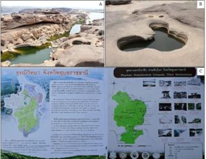
Figure 10. A) Sam Phan Bok, B) the outstanding pothole, and C) The geoscientific panel in the Pha Chan-Sam Phan Bok Geopark
The Pha Chan Area is a potential project in the near future where a geological park can be established by the Department of Mineral Resources of Thailand (Fig. 10C), in order to promote and educate the local sediments and sedimentary rocks along the Mekong River, particularly the potholes of Sam Phan Bok displaying considerable aesthetic value to the tourist. As a geopark, headquarters can manage site protection and present scientific aspects of the geosite as well as their geologic evolution. Both the turbulent flow of the Mekong River and the weakness of joints can lead to important erosion and deterioration of this geosite. An assessment of the erosion and weathering trend of the sedimentary rocks can be part of the conservation plan, especially the potholes that lie in the Mekong River.
The Pha Chan Area is a local nature attraction, advertised as an interesting site easy to reach by the road (Highway 211). However, the area lacks scientific data regarding landform evolution and rock origin. As these geosites lies near a local community, accommodation and food are managed by local villagers and present in many places. Pha Chan trail is about 5 kilometers long with many attractive tourist spots and beautiful viewpoints of the two sides of the Mekong. The walking path in the Mekong River at Salueng River Beach takes tourists towards smaller geological features in the south. Due to the large water volume carried by the Mekong River during the rainy season (June-September), all geosites are flooded in the area cannot be visited.
Evaluation
The SWOT analysis was used to evaluate the study area. In addition, it is also a strategic planning technique used to identify strengths, weaknesses, opportunities, and threats and can be a useful tool to manage the Pha Chan–Sam Phan Bok geopark project. This evaluation was conducted by the qualitative assessment method that is listing the data of strengths, weaknesses, opportunities, and threats of each area (Table 1). Strengths and weaknesses are often internal (domestic) factors of an area, while opportunities and threats generally relate to external factors. The strengths and weaknesses are considered from both an internal perspective, and from tourists and local people. To explore the opportunities, it is necessary to look at the strengths and discuss whether they are able to open up any opportunities. Alternatively, looking at the weaknesses, we can speculate whether elimination of weaknesses could open up opportunities. In term of threats, considering what obstacles it faces or how negative factors could seriously threaten the area.
Table 1. strategic planning technique used to identify strengths, weaknesses, opportunities, and threats related to the Pha Chan – Sam Phan Bok geopark project
SWOT | Kaeng Tana National Park | Pha Taem National Park | Pha Chan Area |
S: Strengths |
|
|
|
W: Weaknesses |
|
|
|
O: Opportunities |
|
|
|
| |||
| |||
T: Threats |
|
|
|
This analysis is an effective method, which can be used for plan management that takes many factors into consideration. The SWOT analysis is used to increase the strengths and opportunities while decreasing the impact of the weaknesses and threats. All of the study areas are national parks, which is a major positive point for its potential for research and public education, and not only on geological interest but also on indigenous flora and fauna, objects of archaeological, historical and others. In addition, the region possesses a high aesthetic value which makes the area more attractive.
Moreover, this work has a comparative study with the Khorat Geopark about their geodiversity and scope. These Geoparks are located on the same plateau “Khorat Plateau”; Khorat Geopark is the western edge and Pha Chan - Sam Phan Bok Geopark is the eastern edge. Based on the rock type, they have some differences of geodiversity that result in their scope. The Pha Chan- Sam Phan Bok Geopark mostly consists of sandstone and is controlled by the Cenozoic faults along the Mekong River; therefore, it has many geodiversity such as cliff, waterfall, rapid, pothole, and mushroom rock. In the case of the Khorat Geopark, it does not have a big river like the Mekong River, but there are many rock types such as sandstone, limestone, and volcanic rocks that make it has various fossil excavation and geological sites. Nowadays, the Khorat Geopark is becoming the UNESCO Global Geopark in the near future. So, the Pha Chan - Sam Phan Bok Geopark is also suitable as global rank if it has better management and support. In term of quantitative or numerically assessment, the researcher focuses on the values of each geoheritage site such as science, education, culture, history, nature, aesthetically, tourism, and economy. Table 2 presents the scores obtained for each site in respect to their geodiversity and geoheritage values based on six classes of assessment: 0 = none; 1 = very bad; 2 = bad; 3 = fair; 4 = good; and 5 = very good.
Discussion and Development for Geotourism
The selected geosite for this study are the outstanding and well-known attractions of this region, which represent the various sedimentary rocks geoheritage. Many interesting landforms in Thailand are presented as geosites rather poorly, offering an insufficient geologic interpretation to the public. Thai people do not understand geologic processes and their earth's evolution, so, all of these areas should have the geologic panel, geologic education center or museum for describing geoscientific knowledge of each area. This study intends to publicize these geosite for international geotourism.
Table 2 assessment of the Pha Chan – Sam Phan Bok geopark, Thailand
Area | Geoheritage | Geodiversitya | Scopeb | Value | |||||||||||||||||||
Rock | Mineral | Fossil | Landform | Landscape | Process | Other Resources | Mineralogical Site | Structural Site | Geomorphological Site | Hydrogeological Site | Petrological Site | Stratigraphic Site | Speleological Site | Science & education | Culture | History | Nature | Aesthetically | Tourism | Economy | Total | ||
Kaeng Tana National Park | Kaeng Tana Rapid | ✓ | - | - | ✓ | ✓ | ✓ | - | - | ✓ | ✓ | - | ✓ | ✓ | - | 5 | 0 | 3 | 5 | 4 | 5 | 3 | 25 |
Mun River | - | - | - | ✓ | ✓ | ✓ | ✓ | - | ✓ | ✓ | ✓ | - | - | - | 3 | 4 | 3 | 4 | 5 | 5 | 5 | 29 | |
Tat Ton Waterfall | ✓ | - | - | ✓ | ✓ | ✓ | - | - | ✓ | ✓ | ✓ | ✓ | ✓ | - | 4 | 0 | 0 | 4 | 5 | 4 | 0 | 17 | |
Pha Taem National Park | Pha Taem Cliff | ✓ | - | - | ✓ | ✓ | - | - | - | ✓ | ✓ | - | ✓ | ✓ | - | 5 | 4 | 5 | 5 | 5 | 5 | 5 | 34 |
Mushroom Rock Pillar | ✓ | - | - | ✓ | ✓ | - | - | - | ✓ | ✓ | - | ✓ | ✓ | - | 5 | 0 | 0 | 4 | 3 | 3 | 0 | 15 | |
Soi Sawan Waterfall | ✓ | - | - | ✓ | ✓ | ✓ | - | - | ✓ | ✓ | ✓ | ✓ | ✓ | - | 4 | 0 | 0 | 5 | 5 | 5 | 5 | 24 | |
Saeng Chan/ Long Ru Waterfall | ✓ | - | - | ✓ | ✓ | ✓ | - | - | ✓ | ✓ | ✓ | ✓ | ✓ | - | 4 | 0 | 0 | 5 | 5 | 4 | 2 | 20 | |
Thung Na Mueang Waterfall | ✓ | - | - | ✓ | ✓ | ✓ | - | - | ✓ | ✓ | ✓ | ✓ | ✓ | - | 4 | 0 | 0 | 5 | 5 | 3 | 2 | 19 | |
Pha Chan Area | Pha Chan Cliff | ✓ | - | - | ✓ | ✓ | - | - | ✓ | ✓ | - | ✓ | ✓ | - | 3 | 3 | 0 | 5 | 4 | 3 | 2 | 20 | |
Sam Phan Bok | ✓ | - | - | ✓ | ✓ | ✓ | - | - | ✓ | ✓ | - | ✓ | ✓ | - | 5 | 3 | 0 | 4 | 5 | 5 | 5 | 27 | |
Salueng River Beach | ✓ | - | - | ✓ | ✓ | ✓ | ✓ | - | ✓ | ✓ | - | ✓ | ✓ | - | 4 | 4 | 0 | 3 | 3 | 4 | 4 | 22 | |
Kaeng Cham Dao Rapid | ✓ | - | - | ✓ | ✓ | ✓ | - | - | ✓ | ✓ | - | ✓ | ✓ | - | 3 | 0 | 0 | 3 | 4 | 3 | 3 | 16 | |
a Gray 2005, b Brocx and Semeniuk 2007; Predrag and Mirela 2010
Note: 0 = none; 1 = very bad; 2 = bad; 3 = fair; 4 = good; and 5 = very good
Kaeng Tana and Pha Taem National Park described their rock and formation in their websites (http://park.dnp.go.th/visitor/nationparkshow.php?PTA_CODE=1031 and http://park.dnp.go.th/visitor/nationparkshow.php?PTA_CODE=1073), and tourists can obtain this data before travel. Since Pha Chan Area is not a national park, it was not mentioned in the website. However, the visitor can learn about geoscientific knowledge inside the geopark office. These sites are considered as aesthetic attractions rather than geosites, which are interested in geoscientific knowledge (Brilha & Reynard 2017). There are comfortable roads to reach tourist to each attraction, and they can walk distances about 50 meters from the nearest parking areas. Geoheritage is presented as an open-air exhibition of rocks and promotes the aesthetic value of the cultural landscapes. However, an essential geomorphological component is missing because Thai people do not understand the geologic process.
The highlight of this study is the famous potholes of the sandstone bed, which are a result of Mekong river erosion that only affects these outcrops to the exclusion of all other places in the region. The Mekong River flows through the Phu Phan Formation of the Khorat Group and makes the circular current of water, which carries gravels to wear away a rock surface in Ubon Ratchathani only. The gravels (granule - pebble size) eroded the sandstone bed as the potholes. This sandstone consists of quartz-gravel in a medium-coarse sand matrix made of quartz, feldspar, and mica, with clay cementation leading to the efficient removal of gravels. This particular lithology could explain the absence of such potholes in another part of the river bed due to the absence of a pebbly sandstone basement. Small streams flowing on this pebbly sandstone bed, may also form potholes but the size and number depend on stream current and size. For example, in the Saeng Chan Cascade, the stream hits against the hole and flow to the creek below.
Tourist will be interested, provided that a story or chart of occurrence and evolution in each these geosites will be provided and easily understood. All of the potential studied geosites are distributed in the Sao Khua and Phu Phan Formations. The scientific meaning can describe the sedimentary rocks and their origin, including the transportation of pebbly sandstone. Both Sao Khua and Phu Phan Formations are mainly made up of metamorphic quartz sediments. Racey et al. (1996) initially suggested that the bulk of these sediments may have been derived by stream process from the Kontum Massif, which is at the eastern flank of this area. In addition, some input from the Louangphabang and Truongson Belts and Rao Cao Massif, which are covered in the area in the north and NE of the studied area. These provenances are older than 150 million years ago, which is more than the age of both formations and transported from Laos, according to cross bedding value from field observations, suggesting that sediment transport directions are dominantly from the NE, with a minor component from the east (Racey et al., 1996).
The three study areas differ by the diversity of geological heritage features, and the number of features is the highest in the case of the Pha Taem National Park. According to the characterization and classification results, the common types of this research are geomorphological, structural, stratigraphic, petrological, and hydrological features (Table 2). These include the cliffs mentioned above (“Pha Taem”, “Pha Chana Dai”, and “Pha Chan”), as well as the river, rapids, cascade, stack, and potholes took entirely. The geological heritage is the significance geodiversity for humanity and can be characterized either quantitatively or qualitatively (Gray, 2008, 2013; Ruban, 2010; Knight, 2011; Crawford and Black, 2012). The Pha Chan - Sam Phan Bok Geopark has a various diversity of geology such as rock, landform, landscape, and water process as well as there are water resources, and sand resources in the Mekong and Mun rivers (Table 2).
As demonstrated above, the geological features of the studied territory are chiefly of intermediate to low ranks (local or regional). However, the co-occurrence of diverse features (natural and cultural diversities) by itself increases the overall rank of these entities (such a situation was discussed by Ruban (2010)). Rare places of the world can present such a peculiar geomorphological and geological feature as the edge of the Khorat Plateau and the area nearby them. The Khorat Plateau has many types of attraction for developing to geopark such as the Khorat Geopark (Fig. 1). As such, the entire geological heritage of the studied territory, i.e., the Pha Taem National Park, can be ranked as global such a previous comparative study with the Khorat Geopark. The Pha Taem National Park is the first area to see the sunrise of Thailand and also has the greatest mushroom rocks and cliff along the Mekong river, the main river of southeast Asia. In the future, the cooperation of the Department of Mineral Resources of Thailand and local networks will start to manage this area as Global Geoparks that include many interesting geosites, rigorous rules of geosite protection, and available geological data for tourists.
Furthermore, the explanation panel of landform evolution and rock origin should be there to complete this geopark of northeastern Thailand. The aim of this work to educate tourists to understand the geological processes and be aware of the needed conservation in their geologic monuments. Moreover, it is the new tourism announcement in Thailand, which will have effects on the economy. In addition, the effective management of geotourism can be an advantage for sustainable development in both the local and national community. However, if the government and the headquarter of the park not concentrate on this management, can be a threat to geoheritage resources. Promoting people to visit this area without sufficient protective regulation could eventually mean a destruction of the geosite. As geotourism is part of a recent announcement of targeting following the purpose of the twelve National Economic and Social Development Plan (2017-2021) of Thailand by the Thai government, additional revenue can be obtained and sustainable (Office of the Prime Minister, 2017).
Conclusions
The present study underlines the importance of geological heritage inventory in the northeastern region of Thailand known as the Khorat Plateau. The diverse geological features of the Pha Chan - Sam Phan Bok Geopark are an essential part of the geological heritage. There are 15 geomorphological sites where have uniqueness, representative, and identity in this geopark, which is the protectorate area of the Kaeng Tana National Park, Pha Taem National Park, and Pha Chan Area, accordingly, these geoheritage sites always are conserved and protected by the authority of the national park. Meanwhile, this research also presents the characteristic of sedimentary weathering and erosion that will cause geosites destruction. Furthermore, it creates a way for people to understand the geological processes and to be aware of the conservation challenges of their geologic monuments. The eastern edge of Khorat Plateau and the area nearby have particularly outstanding geosites, which are well suited for geotourism development. The aspiring national geopark can contribute substantially to both geoconservation and geotourism for promoting a new type of tourism of Thailand, resulting in economic, social, and geologic developments.
Acknowledgments
The fund of this research was supported by the Science Achievement Scholarship of Thailand (SAST). Dr. Cassian Pirard of the College of Science and Engineering, James Cook University, Queensland, Australia is thanked for his comments and reviews on the manuscript for English language clarity. We also thank Mr. Adiruj Phetpradid and Miss Nontarat Nimsuwan for their kindness in helping of fieldwork.