Introduction
This is the first special issue of Geoconservation Research, focussing on ‘Geoconservation in the Carpathian area’. The aim in this volume was to select a geographic region that spans several nations, and to explore common issues. Although connected by natural assets, mainly the Carpathian Mountains and Danube River, each nation has its own laws and attitudes regarding nature protection, i.e. regional and global geoconservation framework. In other words, the foundation of identifying and justifying the sites must be international, whereas the actual legal protections and development of geoparks and geotourism depend on national and local government.
The Carpathian Mountains: Geology and Conservation
The Carpathian Mountains form an arc through Central and Eastern Europe some 1500 km long (Fig. 1), and they are the third longest European mountain chain, after the Ural Mountains (2500 km) and the Scandinavian Mountains (1500 km long). The Carpathians fall into three sections and spread over the territory of eight countries, the Western Carpathians (Austria, Czech Republic, Poland, Slovakia and Hungary), the Eastern Carpathians (southeastern Poland, eastern Slovakia, Ukraine, and Romania), and the Southern Carpathians (Romania and eastern Serbia).
In biological conservation terms, the Carpathians are important as home to the largest European populations of brown bears, wolves, lynxes and chamois, living in largely virgin forests that contain well over one-third of European plant species. Habitats range from lowland forests to alpine meadows, and the region offers a broad range of interesting tensions between industrial development, road building, and farming on the one hand and wildlife and landscape conservation on the other.
The geology of the Carpathians has been studied in great detail (Royden et al. 1983; Bada et al. 1999; Ustaszewski et al., 2009; Kozak et al. 2013). The Alpine-Mediterranean region has been recognized as a zone where the Eurasian and African (Nubian sensu stricto) continental plates converged since the Late Cretaceous and through the entire Cenozoic (Horváth 1993). While the region experienced an overall compressional tectonic regime, from time to time since the Oligocene temporal extensional basins formed in association with localized subduction and volcanic arc formation (Horváth et al. 2015). One of the largest extensional basins within the convergent plate margins forming the Alpine orogenic system produced the Pannonian basin in eastern Central Europe (e.g. Houseman & Gemmer 2007). This complex Miocene to Quaternary sedimentary basin is encircled by the Alpine, Carpathian and Dinaric mountains. In geological context, the Pannonian Basin overlies two distinct orogenic terranes, the Alcapa and Tisza-Dacia tectonic blocks, each derived from strikingly different paleogeographic positions within the Alpine orogenic system (Horvath et al. 2015). As the region experienced a great variety of magmatism from ignimbrite-forming super-eruptions influencing the entire region to small-volume intraplate monogenetic volcanism, the Carpathian-Pannonian (Lexa et al. 2010; Harangi et al. 2015) has become a geological wonderland and natural laboratory of many geological processes. This complex geotectonic framework produced a geosystem which is the basis of the unusually high geodiversity of the region within a relatively small area.
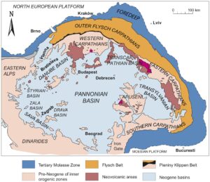
Figure 1. Geological map of the Carpathians and adjacent areas (modified from Golonka et al. 2018).
The Carpathian Mountains were uplifted by the Alpine Orogeny of the late Mesozoic and Cenozoic, when the western Tethys Ocean closed by northward movement of the African tectonic plate into southern Europe, raising the Atlas Mountains in north Africa, the Alps in central Europe, the Carpathians in central and eastern Europe, and the Taurus, Caucasus, and Zagros mountains in Turkey and western Asia. The Carpathian Mountains are a fold and thrust belt, verging northwards in the western part, northeast to eastwards in the eastern part and southeast in the southern part. As the mountains were uplifted by tectonic forces, a broad, flat area, dominated by the Great Hungarian Plain geographically as the surface expression of the broader Pannonian Basin (Fig. 1), remained inside the arc, filling subsequently with sediment and providing rich farmland largely over Hungary (the Middle Danube Basin).
The northern portion of the orogenic belt is a Tertiary accretionary prism, the Carpathian Flysch Belt, formed by wedges of marine sedimentary successions scraped off the seabed as the African plate subducted, and then thrust over the North European plate. The Carpathian accretionary prism comprises successions of Cretaceous and Paleogene turbidites. As these were thrust northwards over older rocks, the Carpathian foreland basin was formed (Nehyba & Šikula 2007).
Between this flysch belt and internal zones of the orogenic belt in the Western Carpathians is the Pieniny Klippen Belt (PKB), a narrow (0.4–19 km) but elongate (about 600 km) belt of polyphase compressional deformation, later involved in a strike-slip zone (Mišík 1997; Jurewicz 2005). The zone exposes klippes (remnant portions of a nappe after erosion has removed connecting portions of the nappe) of Jurassic and Lower Cretaceous limestones that are divorced from their original sources. Geophysical studies (Golonka et al. 2018, 2019) show that from the Albian to Miocene the PKB originated as an accretionary prism in front of the moving Central Carpathian Plate, followed by plate rotation and strike-slip processes. The entire Central Carpathian nappe pile is thrust over the Precambrian and Lower Paleozoic crystalline basement of the European Plate and probably slices of the PKB. The PKB documents two phases of intense tectonic activity during the Alpine Orogeny, the Laramide (Jarmuta) phase in the Cretaceous and Paleogene with thrusting of the nappes, and the Savian (Helvetian) phase when the ocean was subducted causing the formation of the Carpathian Flysch Belt.
Internal zones in the western and eastern Carpathians expose older Variscan igneous massifs reworked into Mesozoic thick and thin-skinned nappes. During the Middle Miocene this zone was affected by intensive calc-alkaline arc volcanism that developed over the subduction zone of the flysch basins (Pécskay et al. 2006; Lexa et al. 2010). At the same time, the internal zones of the orogenic belt were affected by large extensional structures of the back-arc Pannonian Basin (Royden et al. 1983; Dolton 2006). The last volcanic activity occurred at Ciomadul in central Romania about 30,000 years ago (Molnár et al. 2019; Lahitte et al. 2019; Karátson et al. 2019). Described complex and intensive geological evolution of Carpathians is a reason why this relatively small area is characterized by exceptional geodiversity.
Copper, iron, gold and silver were found in great quantities in the Carpathians. Rudna Glava (Ore Head) is a mining site in present-day eastern Serbia that demonstrates one of the earliest evidences of European copper mining and metallurgy, dating to the 5th millennium BC (Jovanović 2009; Petković 2009). After the Roman emperor Trajan's conquest of Dacia in 101–102 AD and 105–106 AD, he brought back to Rome over 165 tons of gold and 330 tons of silver (Morteani & Northover 1995). Most of the gold-silver ore deposits of the broader Carpathians are located in the Apuseni Mountains in Transylvania, western Romania, now forming the Apuseni Nature Park, protected for its natural karst landscapes, caves, Pleistocene bone deposits, plants and wildlife. The intense, but short-lived Roman occupation of the province of Dacia depended heavily on these mineral resources and left a permanent stamp on the landscape that is part of the landscape and cultural heritage of the area (Stoiculescu et al., 2014). Current mineral extraction creates continuing conflict over balancing economic and heritage concerns in the area (Cocean 2012).
The Transylvanian Golden Triangle hosted many mining locations dating back through centuries of operation, which have yielded many minerals that received their names from the Carpathian realms, including nagyágite [Pb5Au(Te,Sb)4S5-8], referring to the Nagyág mine, its former Hungarian name (now Sacaramb), Romania. Mineral names also directly reflect the origin of minerals such as sylvanite [(Au,Ag)Te4] which is derived from sylvanium, an original name proposed for the element tellurium. Tellurium is present within sylvanite, and its first documented occurrence was in the Transylvania region of Romania - hence the name sylvanium. Many of these unique minerals reached major collections across Europe, influencing the evolution of mineralogy as science (Mottana et al. 2012). The eastern Carpathians also host many unique igneous rocks. One of them is ditroite from the Ditró/ Ditrau Complex, which is a nepheline-syenite variety with exotic minerals such as sodalite, cancrinite and nepheline. The rock got its name from its type locality from Ditrău’s ancient name of Ditró (Streckeisen & Hunziker 1974). Interestingly, the study of this rock through its geological mapping led Albert Streckeisen (1931, 1974, 1976) to come up with an easy to use field classification scheme to distinguish and name intrusive igneous rocks on the basis of their non-coloured mineral content (quartz, plagioclase, K-feldspar and foidite).
In summary, we can state that the Carpathians truly the cradle of Earth Sciences and it has a great geodiversity, strong geoheritage and locations deserve Geoconservation.
Special Issue
In this special issue we include articles from Hungary, Romania, Serbia and Ukraine, illustrating a range of geological interests and geoconservation issues. In all cases, the sites show the mix of regional-international and local concerns, noted earlier. Crucial in all cases is that the rationale for identification of a site or area for conservation is the scientific argument: a site must show unique and high-quality geological features that are recognized as significant at regional or international scale. This requirement provides a benchmark worldwide so that all designated geosites are important scientifically at a high level, wherever they may be located, and this then provides a marker that can be used locally to explain why a resource is important and so engender local pride and value for the sites.
Dan Grigorescu (Grigorescu 2020) presents a detailed overview of the Haţeg region of Transylvania-Romania, famed for its dinosaur fossils for over 100 years, and a key geoconservation area in Romania. He describes how early scientific work by Baron Franz Nopcsa from 1897 to 1929 established the world importance of the sites and the area, not least for the fossil finds themselves, but also because this has become recognized as significant because the dinosaurs show evidence of insular dwarfism. Grigorescu describes how he has led continuing efforts in Romania to achieve recognition and funding for research and conservation, and then the accolade of recognition by UNESCO of the Haţeg Country as a geopark in 2005.
Sándor Gönczy et al. (2020) take us to the northern end of the Carpathian Mountains where they identify 45 geosites that illustrate important aspects of stratigraphy, volcanism, geomorphology, mineralogy, and tectonics, and that are documented by the Ukrainian Geological Survey. Four of these are located in national parks or nature reserves, and so can be protected and used in education and geotourism, but the other 41 are not inside such protected areas. The methodology for assessment and justification of these 45 geosites is presented and given in the context of nature conservation in the Ukraine. Such methods are required so that the quality and importance of geosites is well documented, and then the problems can be tackled, including lack of interest in conservation of geological sites and their subsequent use in education.
Đurđa Miljković et al. (2020) explore a different kind of geology, namely geomorphology, in eastern Serbia. Their focus is karst, and this region is world-famous as part of the classic defining region for the phenomenon, and the Homolje area displays karst landscape features such as gorges, uvalas (large, karst-enclosed depressions), caves, karst bridges, and tufa accumulations. This is also a relatively unspoiled area hydrologically, with unpolluted watercourses, waterfalls, thermal springs, karsts, and intermittent springs. The Homolje area includes ten named geosites, each representing particular phenomena of international importance, but only two of these, the Osanička River Gorge with karst bridge and the Samar Karst Bridge are protected. The authors describe the tension between convincing the appropriate authorities of the scientific importance of the other locations and of the need for proper conservation action, and potential benefits for the people. Such problems are true in all nations.
Aleksandar Antić et al. (2020) explore a particular feature of the classic karst of eastern Serbia, namely natural stone bridges. These are limestone arches left behind after the underlying carbonate sediments have been dissolved away by rainfall and underwater river flows. The authors apply a specified Geosite Assessment Model which rates sites on a broad range of criteria, including scientific significance, but also accessibility, likely durability, management potential. They conclude that the Vratna River basin achieves the highest ratings by this method for so-called ‘Main Values’, but rates less well for ‘Additional Values’ because the tourism infrastructure is poor.
In the final paper, László Sütő et al. (2020) describe geoconservation and geotourism activities in Hungary, beginning with a programme of nature trails established since 1990 and the Hungarian Geotope Day, established in 2009. The Bükk Region Geopark has been a centre of such activities, most notably the Devil’s Tower Nature Trail, attended by 1000 tourists each year. The paper explores data on the opinions and motivations of these tourists, and points to the importance of gathering feedback as a means to persuade local and regional governments about the value of investing in such outdoor, environmental appreciation activities.