Introduction
The Lanzarote and Chinijo Islands Geopark has been part of the UNESCO Global Geopark Network since 2015. This island Geopark encompasses the northeastern side of the Canarian archipelago. The group of islands and islets that make up the Geopark are part of the volcanic region of Macaronesia and are located just over 100 km from the Moroccan Atlantic coast.
Currently, the Geopark occupies approximately 2500 km2, out of which 866 km2 include subaerial areas of Lanzarote and the Chinijo Islands, comprising the island of La Graciosa and the Roque del Este, Roque del Oeste, Montaña Clara and Alegranza islets. In addition, there is a significantly large underwater area, adding territory to the islands and islets under the waters of the Atlantic. Most underwater areas of the Geopark coincide with the sea abrasion platform associated with these islands and bordering them (Fig. 1).
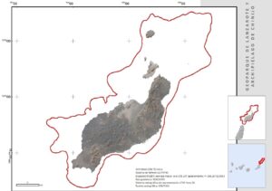
Figure 1. Delimitation of Lanzarote and Chinijo Islands UNESCO Global Geopark.
Lanzarote and the Chinijo Islands; A Unique Geological Heritage Site in Macaronesia
Our Geopark portrays a magnificent example of ancient oceanic volcanic islands where interaction with the volcanic and erosive territory prevails, throughout the past 15 Myr. Further, the current semi-arid climate prevents the concealment of geological features and relief by vegetation. In this sense, the local climate facilitates the visibility and understanding of processes, materials and forms. There were two historical eruptions, in 1730–1736 and 1824 (Romero 1991), and these significantly impacted the landscape and the life of local people.
The formation and evolution of Lanzarote and the Chinijo Islands can be understood through its 82 current geosites, which are part of eight geological frameworks that represent the geology and geodiversity of an oceanic volcanic island with a semi-arid climate. Currently, almost half of the geosites are of fundamental volcanological interest (46%). In addition to these, there is another important set of geosites, also of volcanic origin, whose main interest is fundamentally geomorphological (27%). Along with these, there is a representative percentage of geosites whose main value is sedimentological (11%). It should also be noted that an important portion of the geosites in the current inventory (20%) are linked to the volcanic eruption of Timanfaya (1730–1736 AD) and are located within the area of the Global Geosite "Recent Volcanism of Timanfaya (Lanzarote )” of the Global Geosites Project, which demonstrates the importance of the geological heritage linked to this eruption.
Insularity with 15 Myr of Volcanic Activity
The geological formations that make up the different reliefs of Lanzarote allow for an accurate interpretation of the evolution of the geological history of the island in the past 15 Myr. Analyzing its rocks and reliefs has led to the scientific interpretation of the geological events that took place on the island during the Neogene and Quaternary (Galindo et al. 2015).
The materials that build the island of Lanzarote and the Chinijo Islands are almost fully basaltic. They were created after three large cycles or constructive stages of which the first was exclusively underwater and the other two were subaerial (Romero 2003). During the Oligocene, the initial construction phase of the island took place, consolidating the island base (basal complex), combining underwater volcanic materials, sedimentary buildup and a high volume of plutonic rocks from magmatic intrusion (Carracedo and Rodriguez-Badiola 1993).
During the Mio-Pliocene and the Pleistocene-Holocene the last two stages of construction of the island took place. There was a long period of eruptive calm between both construction stages, and no volcanic events capable of altering the island’s relief occurred (Romero 2003). This period without eruptions lasted at least 2.5 Myr (Galindo et al. 2015) and during that time, erosion was especially significant, leading to some of the most unique erosive reliefs on volcanic materials in the Canary Islands.
Unlike other enclaves on our islands, there are no subaerial outcrops in Lanzarote or the Chinijo Islands that expose to view the materials and structures of the base of the island. Nonetheless, the composition of materials, sequences and structures are currently well-known thanks to research projects carried out on the island over the last decades. Among them, Sánchez-Guzmán and Abad (1986) stands out as the best characterization of the insular basal complex, based on data from drilling for geothermal prospecting purposes, carried out in the Timanfaya National Park.
The first stage of subaerial construction of the island began at approximately 15 Ma. Then, volcanic activity was spatially and temporally organized around pulses of activity, with calm periods of different durations. This first period of subaerial construction ended at approximately 3.8 Myr (Coello et al. 1992) and during it, large volumes of volcanic material were emitted, leading to the construction of large volcanic edifices whose remains are currently visible in the older areas of the island; Famara and Los Ajaches. It was during this time that the island reached its greatest surface development.
From approximately 2 Ma to the present, Lanzarote has been developing its second stage of subaerial construction. During this period, volcanic activity was dominated by a large fissure, resulting in the configuration of volcanic fields with noticeable structural patterns, in which volcanic alignments made up of volcanic cones of elongated morphologies prevail over the orientation of the predominant fracture (Romero 2003). These Pleistocene eruptions were mainly hydromagmatic and generated basaltic and basanitic magma.
The prevalence of Strombolian eruptive dynamics, with VEI 2-3, favors the development of small cinder cones that contrast with the amplitude of large surfaces of lava fields. The spatial location of these Quaternary eruptions, mostly over older lavas and volcanic deposits, has led to a significant modification of the reliefs of Lanzarote, with a morphological and chromatic diversity contributing to the landscape, one of the main hallmarks of the island (Romero 2003).
On the other hand, the eminently volcanic and insular character of our territory has favored the development of notable episodes of hydrovolcanism, resulting in some of the most spectacular volcanic reliefs of the Geopark. Enclaves such as Montaña Amarilla and islets such as Montaña Clara or Alegranza are clear examples of the singularity of volcanic landscapes in coastal contexts. The latter examples, among the reliefs of the Chinijo Islands, are in themselves portrayals of local geodiversity, natural and cultural references for the population of the islands.
The latest episodes of volcanic activity that took place within the Geopark are historical, having taken place in the last 600 years and there is a considerable amount of documentation recording the eruptive processes in detail. These are the eruptions of Timanfaya, which occurred in the geographic center of Lanzarote between the years 1730 and 1736, and the fissure eruption of 1824 that gave rise to the Tao, Nuevo de Fuego and Tinguatón volcanoes (Romero 1991).
Of these two historical volcanic episodes, Timanfaya stands out. The duration of its period of activity – more than 2000 days of proven volcanic activity, the extent occupied by the materials emitted, approximately 200 km2, a volume of emissions of between 3 and 5 km3 and the evolution of its magma towards olivinic tholeiitic, make it a unique case within the volcanism of the Canary Islands and, overall, of fissure volcanism on the planet (Romero 1991; Carracedo and Rodríguez-Badiola 1993).
The geological singularities of Lanzarote justified that in October 2013 the Cabildo of Lanzarote (Local Administration) sent the necessary documentation to the European Geoparks Network (EGN) to request the recognition of Lanzarote and the Chinijo Islands as a new member of the Global Geoparks Network. In May 2014, members of an evaluation commission visited the island to assess the landscape and suitability of our socio-environmental models of coexistence. After passing the evaluation, the candidacy was accepted on April 1st, 2015, turning the Lanzarote and Chinijo Islands Geopark into number 11 in Spanish territories and number 65 in the EGN (Mateo 2015). Since then, our territory being a Geopark has determined the lines of work of the Local Administration of the island in matters of geoconservation, geotourism and, in general, in terms of sustainable territorial development.
Further, the Chinijo Islands are a great representation of Spanish natural heritage, identified as a Natural Protected Area (NPA), under the category of Natural Parks, making this one of the most highly protected areas in the Canary Islands.
Geotourism Potential; a Geopark facing the challenge of preservation aligned with tourism.
Ever since the mid 1960s, and especially from the 1970s, the island of Lanzarote has been a consolidated tourist destination, welcoming a large number of tourists, with 2,816,231 visitors in 2022 (ISTAC 2022).
Despite the fact that the main attraction of Lanzarote is the traditional "sun and sand” tourist model, their presence on the island represents an important opportunity to advertise other leisure options. A complementary tourist offer is linked to "experiences" associated with the geological, geomorphological, landscape and cultural values that make our Geopark a tourist destination of special uniqueness (Guillén and Mateo 2019).
Traditionally, and in the context of tourism, the term "sun and beach" includes tourist activities around leisure, entertainment and beaches, taking advantage of the sea, sun and heat. The combination of these elements is its main attraction (Zouros and McKeever 2009; Guimarães 2015; Guillén and Mateo 2019). However, many of these mature tourist destinations have started to show some signs of exhaustion in terms of tourists over the years (Álvarez 2004; Corral and Hernández 2010; Dóniz-Páez et al. 2010), which has pushed the tourist agents to find ways to avoid a decline and enable its renewal, addressing, among other aspects, the creation of new products and tourist experiences (Dóniz-Páez 2014). The Geopark is committed to these changes towards diversification, which means providing alternatives in an innovative and unique way and removing unevenness between the traditional offers of this type of destination (Guillén and Mateo 2019).
In recent years, the relevance of aesthetic and landscape values for tourism purposes has been boosted significantly (Carcavilla et al. 2011). It is evident that geotourism, despite being a new idea, is practiced in Spain and the world through the Global Geoparks Network. This consists of interpreting and disseminating geodiversity through the identification of places, areas and/or elements of geological interest and the proposal of geotourism itineraries (Díez-Herrero and Vegas-Salamanca 2011; Dóniz-Páez 2014). Lanzarote is an island with a deeply rooted tradition in this type of project, aimed at the conservation and enhancement of the local geological heritage. These initiatives have resulted in some of the key pillars behind island tourism (Guillén et al. 2015). An example of this is the Network of Art, Culture, and Tourism Centres of the Cabildo of Lanzarote (hereinafter referred to as CACT).
The CACT encompasses a network of publicly owned tourist centers that provide an internationally renowned tourist offer, designed to attract through art, nature and sustainability. The relationship between art and tourism on the island has contributed to the conservation of the landscape and has become a significant social, cultural and economic vector for Lanzarote (Guillén and Mateo 2019). The mission of the CACT is to preserve and defend the values of the island as well as to inspire and generate environmental awareness through their actions. The creation of these spaces started in the 1960s by two important local artists, César Manrique and Jesús Soto. Currently, these infrastructures are linked to the Geopark and welcomed 1,728,229 visits to all the centers in 2021 (normality post-COVID).
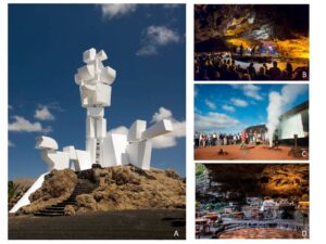
Figure 2. A) Monumento al Campesino over volcanic materials B) Concer inside Cueva de los Verdes. C) Tourist visit in Montañas del Fuego. D) Jameos del Agua.
Among the seven centers, four are located in geosites of the Geopark inventory (Fig. 2):
- Cueva de los Verdes. There are few places with so many aspects of the cultural and natural heritage of Lanzarote as the Cueva de los Verdes does, a unique cave with a mythological appearance, with legendary and outstanding scenic beauty. It resulted from the eruption of Volcán de la Corona and is one of the most impressive hidden wonders of the depths of Lanzarote. It was used as a hideout by locals who needed shelter to protect themselves from invasions and pirate attacks from Northern Africa. In the 19th century it became a must-see for travelers, experts and scientists due to the uniqueness of its territory. Entering Cueva de los Verdes is, without a doubt, like taking a trip to the center of the Earth.
- Montañas del Fuego. These are like a walk on the Moon on Earth. They originated after the volcanic eruptions in the south of Lanzarote between 1730 and 1736 resulting in the Timanfaya National Park. Montañas del Fuego has a desert-like beauty and a range of other shades that leave visitors in awe. From the depths of the earth, Islote de Hilario stands out, surrounded by a 200 km2 sea of lava where 25 inactive craters lie. The furnace at El Diablo restaurant uses the natural heat of the earth to cook unique dishes under our feet, ten meters deep, at almost 300 degrees. Extreme heat rises to the surface and creates unforgettable moments for visitors. The natural and artistic landscape of Montañas del Fuego allows tourists to do the Ruta de los Volcanoes in special vehicles to live the experience and see the wonders of nature, in this unique lunar landscape.
- Jameos del Agua. Here, nature and humanity come together. César Manrique knew how to transform what was previously the rubble of a volcanic tube with lava coming out of Volcán de la Corona, in the north of the island, into a unique place in the world. It was his privileged mind and hands, which shaped the coarse black basalt, a place where peace and stillness, harmony and beauty reign. In addition, an original auditorium, unique in the world for its geological and acoustic characteristics, in Jameos del Agua, each detail is a constant opportunity to reflect, look inward and daydream.
- Casa Museo del Campesino. Located in the geographical center of Lanzarote, it is the work of César Manrique paying tribute to the efforts made by Lanzarote farmers, who faced the most adverse conditions and brought the landscape to life. Casa Museo del Campesino is a journey through architecture, agriculture, crafts and traditional Ggastronomy, topped off by the Monumento al Campesino, an avant-garde construction portraying his very own tribute.
As part of the collaborative work between the CACT and the Geopark, linked to a common strategy to promote Geotourism, the new Museum of Casa de los Volcanes (in Jameos del Agua) stands out. This museum aims to show the public, in an entertaining and informative way, the importance of studying volcanoes and multidisciplinary research in geosciences, including observations related to geodynamic activity, the ocean-earth-atmosphere system, environmental monitoring in underground systems, and studies of extraterrestrial settings, among others. Several rooms are dedicated to the Geopark, geological Heritage, biotic, and cultural heritage. The scientific supervision of the contents has been carried out by the Geopark itself. The number of visitors to Jameos del Agua, where the Museum is located, was 571,666 in 2022 (source, CACT).
To guarantee excellence in sustainable tourism, added to the work carried out with the CACT, the Lanzarote and Chinijo Islands UNESCO Global Geopark (UGGp) carries out training actions aimed at raising awareness of our geological heritage, favoring more responsible behavior by tourists and locals. The specialized training, targeting tourism, has been conducted by different groups: hotel staff, students of the Faculty of Tourism, Professional Training in Tourism students, tourism brand certifications, and a group considered essential when it comes to communication with visitors, tour guides.
Likewise, and to favor the achievement of the basic objectives of awareness and visibility of the tourist resources associated with geotourism on the island, in recent years different informative and interpretative content has been produced, including brochures on good visitor practices, Geopark maps, Geopark guides, specialized routes such as the “Car Geo-route through the Lanzarote and Chinijo Islands in ESP/ENG”, and interpretive panels on local paths and public roads (Galindo et al 2017).
Preserving Lanzarote and the Chinijo Islands Geopark: Actions, Solutions and Determining Factors.
The Canary Islands treasure an important natural heritage that at first sight is clearly represented by their landscapes. These reflect the diversity of local ecosystems, most of which significantly show their geological and geomorphological values. To protect this natural heritage, a high percentage of the territory of the Canary Islands is currently under the protection of one of the different categories recognized by the Canary Islands Network of Protected Natural Spaces, as well territories recognized as Special Protection Areas (ZEC) or Special Protection Areas for Birds (ZEPA).
The international recognition of the natural heritage of the Canary Islands is endorsed by the inclusion of two of its most unique natural enclaves on the World Heritage List, as well as by the declaration of another seven territories as Biosphere Reserves, two of them as UNESCO Global Geoparks. All of these recognitions make the Canary Islands a unique archipelago when it comes to natural assets, with very few other international examples of areas with similar features.
Nationally speaking, in Spain, Protected Natural Areas are defined and regulated by Law 42/2007, of December 13th, regarding Natural Heritage and Biodiversity, which groups them into three large groups based on legal frameworks; Natural Protected Areas, Natura 2000 Network and areas protected by international instruments (Law 42/2007). However, a large part of the powers in terms of protection of the territory and natural heritage in Spain are delegated to the Autonomous Communities, including powers in matters of regulatory enforcement, as well as territorial management and environmental protection, as well as recognizing the right to enact laws in this regard.
Currently, the main legal tool developed at a regional level to try to guarantee the sustainable development of the islands, as well as the responsible use of their natural and territorial resources, is Law 4/2017, of July 13th, on land and Protected Natural Areas of the Canary Islands. This law seeks to facilitate financial and social activities in certain spaces considered suitable for development or recovery, notwithstanding maintaining the protection and preservation of spaces and territories of great natural value on our islands. Part of the fundamental principles that inspire this law, directly targets local geodiversity as an essential part of the natural resources of the islands, their landscape and the cultural heritage of a Canarian society with such outstanding volcanic areas, generous when it comes to resources but fragile in terms of absorption capacity of many of the impacts from human activities (Law 4/2017).
This law is based on the constitutional principle of sustainable development as the guiding criterion behind planning and intervention on the islands. The balance pursued by the law rests on a simple understanding: facilitating financial and social activity on the land, suitable for development or recovery, renewing the applicable rules, and, in addition, maintaining the protection and preservation of valuable spaces and land on the islands, either because of their natural assets –natural spaces, rustic land, or because they ensure the sustainability of that development – compactness of the urban, restriction of tourist landscapes.
Locally speaking, the Island Councils, like the Cabildo of Lanzarote, constitute a key component when it comes to surveillance, management and maintenance of many of the natural heritage assets in the Canary Islands. In addition, for initiatives such as achieving recognition of our Unesco Global Geopark, the Cabildo has been an essential element for promotion and consolidation at a local scale. This island administration has significant recognition on the islands, making it the main tool in public administration to promote strategies that favor territorial coherence and sustainable development strategies. In most cases, this unifying role facilitates synergies and the optimization of resources and the coherence of the actions planned among administrations with power over the territory of the islands. This also applies to Lanzarote, an island that currently has 45% of its territory under one of the protection figures provided for by Spanish regulations, spaces in which different Public Administrations act simultaneously (Table 1).
Table 1. List of Protected Natural Areas of Lanzarote and Chinijo Islands UNESCO Global Geopark.
Type of Legislation | Type of Area | Name |
National | National Park | Timanfaya |
Protected Spaces Network Autonomous
| Natural Integral Reserve | Islets |
Natural Park | Chinijo Islands | |
The Volcanes | ||
Natural Monument | La Corona | |
Los Ajaches | ||
La Cueva de los Naturalistas | ||
Islote de Halcones | ||
Montañas del Fuego | ||
Protected Landscape | Tenegüime | |
La Geria | ||
Scientific Interest Site | Los Jameos | |
Janubio | ||
The Natura 2000 protected areas Network (European) |
Special Areas of Conservation SAC | La Corona |
Los Islotes | ||
Los Risquetes | ||
Los Volcanes | ||
Malpaís del Cuchillo | ||
Parque Nacional de Timanfaya | ||
Cagafrecho | ||
Sebadales de Guacimeta | ||
Sebadales de La Graciosa | ||
Los Jameos | ||
Archipiélago Chinijo | ||
Special Protection Areas (for birds) SPA | Timanfaya Natural Park | |
La Geria | ||
Llanos de la Corona and Tegala Grande | ||
Llanos de la Mareta and Cantil del Rubicón | ||
Los Ajaches | ||
Salinas de Janubio | ||
Lanzarote Northern Islets and Riscos de Famara |
At present, the Geopark is a key tool for the preservation of geological heritage, as well as for the promotion of actions aimed at promoting sustainable island development, respecting the local geological heritage and its determining role in the natural and cultural heritage of the islands.
For these purposes, the UGGp has a Management Strategy that is updated every four years (coinciding with each revalidation) that is materialized through an Annual Action Plan. This ensures the work, control actions and improvements in results. The Management Strategy is drawn up through processes in which the local community participates, including action proposals from a wide spectrum of fields. The annual Action Plans currently include measures to meet the objectives and expectations of the UGGp, like those concerning sustainable development, geotourism and geoconservation.
Specifically, actions aimed at geoconservation have been part of the essence of this Geopark since the start. To date, these actions have been carried out mainly by direct intervention initiatives through institutions and public administrations with competencies in environmental preservation and territorial management. These actions can be divided into those aimed at identifying and improving knowledge of the local geological heritage, those aimed at the direct preservation of the physical elements that are part of the local geological heritage, and those aimed at improving the control of uses and monitoring the impact on spaces of high geological value of the Geopark. The following are some examples of actions currently carried out by the Geopark along these lines:
- Actions to increase awareness of the local geological heritage.
- Updating the inventory of Sites of Geological Interest in Lanzarote and the Chinijo Islands. The first UGGp inventory was carried out in 2013, to submit the UNESCO Global Geopark application. This first inventory included 63 geosites, 19 of them located below the current level of the Atlantic waters. During 2019–2022, a revision of the list of geosites associated with the Geopark expanded the list of geosites to 80, almost half of which are mainly volcanological (46%), followed by geomorphological (27%) and sedimentological (11%) with small numbers addressing paleontological, stratigraphic, tectonic, petrological, and hydrogeological values.
- Inventory of Underground Geological Heritage (volcanic tubes, caves and volcanic summits). Currently, the Geopark (UGGp) is cataloguing the geological heritage associated with volcanic cavities. Given the volcanic nature of the island and the history of fundamentally effusive eruptive dynamics, as well as the unique character of of cavities, new works aim at recognizing, inventorying and assessing these elements, as well as measures for preservation. New geosites are expected to be derived and incorporated into existing ones.
- Elimination of rock buildup of anthropogenic origin. Within the Geopark, people have long enjoyed creating structures from stones without mortar, for signaling purposes, artistic expression or simply linked to a broad set of beliefs. These actions have significantly modified local landscapes, and sometimes substantially changed local ecosystems. Currently, the Geopark organizes and promotes landscape restitution actions to return the spaces affected to their original state, mostly carried out by local, non-professional groups through voluntary participation. These actions, which can be considered environmental volunteering, are put into practice with parallel activities aimed at improving knowledge of the natural and landscape values linked to the affected areas, aiming to raise awareness among the local population. Although this kind of impact can occur in all areas, currently different campaigns are underway to target the impact of this type of action on the SGI of Vega de San José (Pleistocene endorheic valley with no bedhead).
- Actions for the physical preservation of the local geological heritage, as well as of the territorial and landscape units in which it is integrated.
- Restoration of volcanic cones in Parque Natural de los Volcanes (Island of Lanzarote). These actions are intended to contribute to the recovery of ecosystems in several historic volcanoes, also allowing landscape restoration of some geological landmarks and emblematic landscapes associated with the historic volcanism of Lanzarote and which have been subject to uncontrolled tourist use in recent decades. Among these enclaves of special relevance due to their symbolism on a local scale are the kipuka of Caldereta (intra-lavic spaces of the Timanfaya flow field, 1730–1736), the chasms of the historic Tinguatón volcano (triple eruption of Tao, Nuevo de Fuego and Tinguatón, 1824), the volcanic complex and the main lava channel of Pico Partido-Montaña Señalo (Timanfaya, 1730–1736), and the volcanic construction of Caldera de los Cuervos (first emission center leading to the eruption of Timanfaya in 1730).
- Actions to control Calcosa (Rumex lunaria). The invasion of species is one of the greatest threats to the preservation of a fragile natural heritage in the UGGp. So is the transfer of native species between islands, which end up being invasive, such as Rumex lunaria, a translocated native species that since its introduction has spread throughout a large part of the island. Its control is a priority preservation action in ecosystems associated with historical volcanic flows. Actions to eradicate Rumex lunaria and restore ecosystems are currently being carried out at the historic Corazoncillo volcano, the spatter cones of Hornitos de Echadero de los Camellos, the historic volcanic complex of Montaña Rajada, and the materials associated with the Chinero volcano.
- Elimination of graffiti and waste in Tubo Volcánico de la Corona. This Pleistocene volcanic tube is one of the great treasures of the UGGp, 7.6 km long, with a large number of morphologies among its galleries. Due to easy access through different natural entrances, this space has suffered many acts of vandalism, including garbage dumping and graffiti. In collaboration with local caving groups, the UGGp has carried out measures to clear the mess and restore the original features of these spaces.
- Rodent control tasks, cleaning and maintenance of the tourist center of Hervideros. Los Hervideros is one of the well-established Sites of Geological Interest as an outstanding location to see the effects of differential coastal erosion. From a landscape point of view, it is one of the most unique locations on the Lanzarote coastline, giving rise to iconic images generated from the action of the surf on the cliff side of the Timanfaya basaltic flows. Its proximity to the hydrovolcanic cone of El Golfo, another of the great geological and landscape attractions of the island, has attracted the development of a specific tourist product around both Geological Interest Sites, around enjoyment of the geoforms of the southwestern coast of Yaiza. The high number of visitors to the area requires specific measures to guarantee the preservation of the geological heritage that motivates these same influxes.
- Actions to control the use and monitoring of impacts in areas of high geological value.
- Monitoring Land and Sea Sites of Geological Interest. This work is carried out by qualified personnel, using standardized procedures that facilitate data collection and monitoring for decision-making. This information derives from specific reports thanks to which different conditions to different geosites have been detected and corrected early. These actions are carried out systematically and periodically on all the SGIs in our inventory.
- Surveillance, Exposure and Maintenance Services at the Volcanes Natural Park and adjacent areas. These actions are part of the interventions specifically designed to improve the state of preservation of sites of high geological value. This initiative is designed and implemented in collaboration with the Lanzarote Biosphere Reserve and it is hoped that it will have a positive impact on the sites of Pico Partido, Montaña de El Señalo and a significant part of the lava flows in this sector of Timanfaya.
- Marking project in Famara. This initiative is proposed to prevent the entry of vehicles into the fields of sand and dunes that are part of this geosite. The wide nature and absence of natural barriers that prevent the entry of vehicles to this space is an important challenge for the Geopark.
- GIS-Cartographic study aimed to detect the new open paths of the Jable. In a complementary way to the previous action, this study is proposed to produce a solid basis for intervention in the identification and closure of illegal tracks. This will be accompanied by landscape restoration of topographic features typical of these formations, facilitating the recovery of sand flows and the natural development of their transport and sedimentation dynamics.
Awareness of the Population as a Key Element to Preserve the Geological Heritage
In recent years, Geopark has promoted the work to promote citizen involvement in geoconservation and improve geodiversity management. For an island with a population of 156,112 inhabitants (ISTAC 2022), the contribution of citizens to the preservation of natural heritage is essential. The local population, by number and proximity, constitutes an essential resource for the observation of the territory, helping safeguard its geological values and favoring the responsible and correct use of spaces.
In order to promote citizen involvement, Geopark is currently working to promote public participation through three basic pillars: training the local population; raising awareness of locals and visitors; and promoting active involvement of citizens in actions to preserve geodiversity and responsible use of the territory (Table 2).
Table 2. Activities to promote responsible participation and enjoyment of the spaces within the Geopark aimed at locals and visitors
Type | Concept | Target Audience |
On-site Workshops | I and II Volcanic Caves Events | Speleology Related |
Workshop on the History and Culture of El Jable | General | |
I and II Events about How to Reduce Volcanic Risk | Related to Civil Protection | |
Conference Cycle about “The geological and paleontological heritage of La Graciosa and Lanzarote” | General | |
Audiovisuals | Documentary about The Culture of Volcanoes, Documentary about The Culture of the Jable, Documentary about Our Underwater Geology, 10 points about the UGGp geosites | General |
Cartoons | Nine episodes of “Ale, el Jameito y Liticoso”, four of them subtitled in English | Children |
Interpreted Routes | Geopark…ing around La Geria (including wine tasting at the end of the activity), and Salinas del Janubio (including salt tasting) | General |
Around the coast | Elderly | |
Cultural Performances | Taro (about the life of César Manrique) | General |
Fairs | Stand at the Environment Fair of the Airport, shared stand in FITUR | General |
Handcrafts | Making a chocolate volcano, intervening in the landscape | Mental Health groups, Visually Impaired, Penitentiary Fibromyalgia, Centre, etc. |
Traveling Exhibitions | ESA at Lanzarote Geopark, Underwater Treasures of Geological Interest | General |
Talks | Underwater Treasures of Geological Interest, Sublántida Project. Geological Evolution of Túnel de la Atlántida, 200 anniversary of the eruption of Volcán de Tao | General |
Course | Volcanoes for everyone | Tourism Guides |
Webinar | The past written on the rocks of the “Global UNESCO Lanzarote and Chinijo Islands Geopark”, I Virtual Event, Let’s Talk about Geoparks, (Spanish Geopark Forum, 6 sessions), Volcano Day (with El Hierro UGGp) | General |
Outdoor Storytelling | Unveiling the heart of Cuervo, a Christmas Tale with cello music, Snack at the UGGp | Family |
Workshops | Make your own energy snack, make your volcanic rock, Reuse-create-play, Energy-chef | Children |
Printed Material | Vera Tale in Timanfaya | Teenagers |
The Story of the Old Timanfaya Devil | Children | |
Story of Ale, el Jameito | ||
Túnel de la Atlántida. Geomorphological and Sedimentological features | General-Especialised | |
Fire, Water and Wind. Sites of Geological Interest of the Global UNESCO Lanzarote and Chinijo Islands Geopark | General | |
Lanzarote and Chinijo Islands Geopark: From Earth to Space (Springer) | Especialised | |
UGGp Magazine #1 and #2 | General | |
Talks about the UGGp as part of events organized by others | Sustainable Development and Geotourism (II UGGp Workshop for Latin America and the Caribbean, Colombia), UGGp Lanzarote and Chinijo Archipelago (Geotourism Guide in Global Geoparks of Spain), Conservation management strategies of the basaltic lava area of Lanzarote and Chinijo Islands UGGp (2020 Gotjawal Global Symposium, Jeju, Korea (virtual), Natural Spaces and Geological Heritage (Training for SICTED tourism certification), A Unique Geopark (SGI Canarias Days, IGME), Example of connection between Cultural Heritage and Geological Heritage in the Atlántica Area (Final Results, Interreg Atlantic Area Geoparks), Geotourism in Lanzarote and Chinijo Islands UGGp (Webinar Cycle Azores UGGp), Lanzarote & Chinijo Islands UGGp-Spain (International Geosciences & Geoparks Program Intensive Course, Arab Region) |
General |
In this context, working with the youngest population is especially relevant. The UGGp has an educational program for all age groups in the education program of the Spanish State: infant, primary and secondary (Fig. 3). The project is not only related to the geological part of the Geopark but also addresses issues such as citizen science, geoconservation, primary sector products, culture, flora and fauna of the Geopark, climate change, waste, natural hazards, etc. Further, bonds are created with educational centers of the municipalities who value both the Geopark in general and the Geological Places of Interest that are located near the center, since each center is committed to monitoring a geosite. For this purpose, there is a group of monitors hired by Geopark through a local environmental education company. With this same project, environmental education work is carried out with groups of sports schools and summer camps.
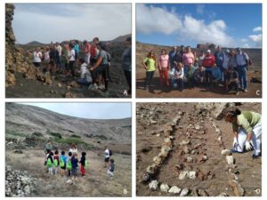
Figure 3. A) Activity “How to Reduce Volcanic Risk?”. B) Environmental activities for children. C) Course “Volcanoes for everyone“ for Tourism Guides, D) Elimination of rock buildup of anthropic origin
At the university level, the UGGp has tutored undergraduate courses (Geography, Environmental Sciences) in terms of professional training, and many students of the Higher Cycle of Education and Environmental Control Technician Diploma have also been tutored. The work conducted by the CACT educational team is also significant, having received some 10,000 students in 2019 (far fewer in 2020 and 2021, due to the Covid 19 pandemic). The work focuses on carrying out educational activities within the CACT, especially led by César Manrique and Jesús Soto.
Another powerful educational team that carries out environmental education work is the Aula de la Naturaleza, like the UGGp, run by the Cabildo of Lanzarote and specialized in creating interpreted routes throughout the entire UGGp.
To reach broader citizen profiles, the UGGP organizes different types of free access activities, whose levels of participation, except during the health crisis caused by COVID-19, have been consolidated over the years.
Conflict of Interest
The authors declare that they have no conflict of interest in this work.