Introduction
The tourism industry, the largest service industry in the world, has a special place in different fields of every country. This industry is one of the primary sources of foreign exchange in more than 150 countries and the primary source in more than 60 countries (Buckley 2011; Camilleri 2018). The American Tourism Industry Association introduced geotourism in 2003 in a report and a publication entitled "National Geographic Tourism" (Samadzadeh et al. 2010; Ólafsdóttir 2019). One of the essential aims of the tourism business is to improve economic and social levels in line with sustainable development (Chylińska & Kołodziejczyk 2018). According to the World Tourism Organization, in 2004, the 10-year growth rate of this industry was 25% (Weaver 2001; Holden 2008). Accurate knowledge of tourism activity plays an essential role in the national development of any country (Beigi & Pakzad 2010).
During the past years, studies and research in the field of geotourism have grown significantly. Among the most important previous studies is Pralong (2005), who introduced and evaluated geomorphosites in the Chamonix-Mont-Blanc area of Switzerland. Pereira (2007) examined 154 geomorphosites in the Montesinho National Park in Portugal from the point of view of investment potential. Reynard (2008), considering the aesthetic, economic, and ecological values as separate criteria, presented a new method for evaluating geotourism based on the main and additional values. Fassoulas et al. (2011) designed a quantitative evaluation model to evaluate the geomorphosites of Silvertis Geopark, Greece. Kubalíková (2019) evaluated two geomorphosites at a local scale in South Moravia. Tomić et al. (2020) investigated the potential of the Danube region for the expansion of geotourism and recommended macro-management planning according to the region's geotourism potential.
Here, the geotourism potential of Gonabad Qasabeh qanat is investigated from the point of view of scientific and educational values, natural landscapes, conservation, performance, and tourism. In addition, weaknesses are identified, and solutions are suggested.
Qasabeh qanat
From its geographical location, Iran is a dry and semi-arid country. In the east and center of the Iranian plateau, due to deficient annual rainfall, surface water flows such as permanent rivers and springs are very limited (Modarres et al. 2007). Life in this area depends on underground water. Knowing this problem, our ancestors invented the "Qanat," the most efficient underground water extraction system in the desert areas of Iran (Papli-Yazdi et al. 1999; Ebrahimi et al. 2021), and the Qasabeh qanat is 2250 years old. Some of the qanats in this region are much more important than others, such as Yazd qanat, Qasabeh qanat, Ferdows qanat, Jupar qanat, and Mehriz qanat. Gonabad Qasabeh qanat is located near Gonabad city, south of Razavi Khorasan Province and in eastern Iran (Fig. 1). Gonabad's catchment area is 1872 km2, almost half in the highlands (mainly in the south), and the other half is in the plains. This area has 300 qanats with an annual discharge of 30 million m3 (Mirani Moghadam et al. 2020). The flow rate of Qasabeh Qanat is 162 l/sec (Hassanpour & Khozaymehnejad 2017). This qanat is a collection of eight qanats in Gonabad city. While the qanats are mostly single-stranded and, in some areas, have three strands, from this point of view, the Gonabad Qasabeh Qanat is a fantastic phenomenon (Fig. 2). Qasabeh Qanat is more than 33 km long, its wells are more than 400 rings, and its mother well is more than 300 m deep at the deepest point (Papli-Yazdi et al. 1999).

Figure 1. The geographical location of Gonabad city, Razavi Khorasan Province, Iran.
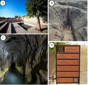
Figure 2. Some pictures from Gonabad Qasabeh qanat. A) qanat outlet B) Entrance No.1 C) A view from inside the qanat D) Qanat entrance board.
Four decades ago, the first discussion of geological sites was presented. However, a comprehensive classification still needs to be provided. Qanats can be studied as geological sites from the hydrogeological, historical, and cultural geological aspects, following principles established for European geosites (Reynard & Lugon 2004; Gray 2008). Although the qanats are artificial, they can be mentioned as the largest and most advanced engineering structures in human history based on geological science.
Methods
The opinions of 141 people were surveyed, including 109 random visitors to the Qasabeh qanat and 32 random local people were questioned in 2021. Their opinions were combined with field visits and library studies by the author. These research methods determine the overall geotourism value of the Qasabeh qanat.
The geosite assessment model (GAM) evaluation method was used, first developed by Vujičić et al. (2011) to investigate the mountains of Serbia in terms of scientific value and other main values. The GAM method is a quantitative-qualitative evaluation model of primary geomorphosites for planning and sustainable development of places with unique natural heritage, and with the aim of turning them into tourist destinations. This model includes main values (scientific/educational, aesthetic value, and protection value) and additional values (functional and tourism). In total, there are 12 sub-indicators of main values and 15 sub-indicators of additional values, which are graded from 0 to 1 that define GAM as a simple equation:
GAM = Main Values (VSE + VSA + VPr) + Additional Values (VFn + VTr)
Results
According to the evaluation, the scientific and educational values of the Qasabeh qanat are at a high level (3.75 of 4). This reflects the uniqueness of Iran, in Asia, and worldwide of the Qasabeh qanat, as well as its educational potential. It is an excellent example of hydrogeological processes because the system is very complete, concrete, and visible, and so will be easy to explain to tourists. Despite its uniqueness, there are no international articles and books specifically about this qanat; articles such as Mirani Moghadam et al. (2021) and Taghavi-Jeloudar et al. (2013) just studied some features of it, and there are no scientific or comprehensive works about this great historical and geological masterpiece.
The Qasabeh qanat received only 2.25 of 4 possible points for aesthetic value because it is mainly underground and does not provide a specifically beautiful landscape. There are two main entrances, Mazhar Qanat, and eight minor wells, and it is possible to imagine good viewing points for this qanat. The proportion and surface area of Qasabeh qanat are at an average level, but the desert location means that vegetation and natural scenery are minimal and insignificant.
This qanat has an excellent score for protection values (3.25 out of 4). Qasabeh qanat has been well cared for during the past decade through the city's macro management and cultural heritage organization, and is without damage in its current condition. On the other hand, according to registration by UNESCO, this qanat has supervisors for its protection at international levels. But it could suffer natural damage because of the many well shafts and entrances in the flood plains. On the other hand, tourists could damage it because of the narrow space of the corridors and the limited inner space, so a suitable number for each tourist tour is 20–50 people.
In the functional values section, this qanat has an average score (3.75 out of 6). It cannot be given a high or even a medium value in terms of nature and vegetation, but this qanat is a historical engineering masterpiece with a high and extraordinary value. However, according to the GAM, this is a single element, scoring 0.25. This qanat is located in a flat and low area, has a very suitable asphalt road, and has many communication networks such as telecommunication and internet networks. Near this qanat, there is an appropriate two-lane asphalt road with access to big cities such as Birjand and Mashhad. Other functional values such as proximity to the city and basic facilities (number of parking spaces and gas stations) provide favorable scores.
Qasabah qanat scores 5.5 out of 9 points for tourism values. It has been advertised nationally in media and newspapers, and many programs and documentaries have been broadcast on national radio and television networks. There are only about 20 organized tourist visits each year (at the time of this research), which is far too low. Most visits are unorganized and personal, and the number of tourists per year is around 35–70,000. The tourism infrastructure near the geosite is medium level, and tour guide services are very few. The qanat is not too far from medical, accommodation, and welfare centers (about 20 km) (Fig. 3). Advertising billboards and notice boards have good quality near this place. There are several restaurants with traditional and national food.
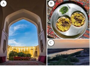
Figure 3. A) One of the native hotels near qanat. B) One kind of traditional food, “Ash-e-Joshpareh.” C) View of vegetation and seasonal river of Gonabad “Kal-e-Shoor.”
Finally, the Gonabad Qasabeh Qanat scored 9.25 out of 12 in main values and 9.25 out of 15 in supplementary values. After placing these two values in the GAM geotourism model evaluation chart (Fig. 4), it was placed in the Z32 area.
Table 1. Result for Gonabad Qasabeh qanat based on the GAM (Vujičić et al. 2011).
Indicators/Subindicators | Current Condition | Grades |
Main Values | ||
Scientific/Educational value (VSE) | 3.75 | |
Rarity | The only occurrence | 1 |
Representativeness | Best | 1 |
Knowledge of geoscientific issues | National publications | 0.75 |
Level of interpretation | Good example of processes and easy to explain to average visitor | 1 |
Scenic/Aesthetic (VSA) | 2.25 | |
Viewpoints | More than six | 1 |
Surface | Medium | 0.5 |
Surrounding landscape and nature | Low | 0.25 |
Environmental fitting of sites | Neutral | 0.5 |
Protection (VPr) | 3.25 | |
Current condition | No damage | 1 |
Protection level | International | 1 |
Vulnerability | Medium (could | 0.5 |
A suitable number of visitors | Could be damaged by natural processes or human activities) | 0.75 |
Additional values | ||
Functional (VFn) | 3.75 | |
Accessibility | Best (by bus) | 1 |
Additional natural values | 1 | 0.25 |
Additional anthropogenic values | 1 | 0.25 |
Vicinity of emissive centers | 25 to 5 km | 0.75 |
Vicinity of the important road network | National | 0.75 |
Additional functional values | High | 0.75 |
Touristic values (VTr) | 5.5 | |
Promotion | National | 0.75 |
Organized visits | 12 to 24 per year | 0.5 |
Vicinity of the visitor center | 20 to 5 km | 0.5 |
Interpretative panels | High quality | 0.75 |
Number of visitors | High (10.001 to 100.000) | 0.75 |
Tourism infrastructure | Medium | 0.5 |
Tour guide service | Low | 0.25 |
Hostelry service | 10–25 km | 0.5 |
Restaurant service | Less than 1 km | 1 |
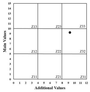
Figure 4. According to the GAM analysis, Gonabad Qasabeh qanat plots in the Z32 sector.
Discussion
Geotourism sites and their development can lead to the sustainable development of local areas (Hose et al. 2011; Kubalíková et al. 2021). Today, international tourists worldwide have reached more than 1 billion people. According to the announcement of the World Travel and Tourism Council, this industry contributes 10.3% of the gross product of tourism destination countries on average (Aldebert et al. 2011; Camilleri 2018).
Today, in addition to natural geological phenomena, places such as museums, which are artificial, are included in the field of geotourism from their geological and tourism values. For example, Turner-Carrión et al. (2021) investigated a mineralogical museum in Ecuador as a geotouristic place using the GAM and several other methods. Their study had magnificent results, concluding that the places built by humans can also have geotourism values, just like natural phenomena. In another example, Herrera-Franco et al. (2021) evaluated a paleontological museum with a high geological value from its animal and plant fossils using the GAM method. Their results also indicated the high value of the museum as a tourist destination. Similarly, as man-made structures, Qanats can also have geotourism potential (Ebrahimi et al. 2021). The Qasabeh qanat could be a geotourism site from its historical and cultural geological values and hydrogeological structure. However, on the way to becoming a global geotourism site, Qanat Qasabeh faces many fundamental but solvable problems and challenges.
Qasabeh qanat was registered as the 20th work of Iran on the UNESCO World Heritage List on July 15, 2016, at the 40th meeting of the World Heritage Committee in Istanbul, Turkey, in the form of the eleven qanats of Iran. The Gonabad Qasabeh qanat has been protected at the national and international levels without any notable damage. Its only weak point may be the presence of wells and the entrances of the qanat as areas exposed to flooding. On the other hand, the inevitable arrival of the tourism community can cause damage. Increasing the cultural awareness of tourists, explaining arrangements and mechanisms such as flood dams, and creating channels that divert the flood path from the qanat, can protect it. The narrow corridors of the qanat limit the number of tourists per visit and are unchangeable. As mentioned, functional values, such as additional natural values, may be unchangeable due to the region's climate. Interestingly, although the value related to human evolution at this qanat is very high as an example of ancient engineering, it is rated as a weakness according to the GAM method.
These weaknesses of the Qasabeh qanat site can be overcome by increasing the level of national and international advertising, signing contracts with international agencies, building a railway and domestic or international airport, increasing restaurants and convenience centers near the qanat, and increasing the possibility of suitable quality accommodation. The increase and variety of cultural programs, the construction of the local market, and the establishment of round-the-clock transportation services in the region can be fixed and turned into strengths. Based on the GAM evaluation model, after calculating the total points of the main and additional values of the Gonabad Qasabeh qanat geosite, it was of Z32 type. The main values for this qanat are high, but the additional values, such as functional and tourism, could be more favorable. In such a situation, it is recommended that according to the region's high potential, managers at the city and country levels should take steps to expand its tourist potential by providing facilities and removing the mentioned obstacles and weaknesses.
Compared to many UNESCO Geoparks worldwide, especially in Eastern Europe, Gonabad Qasabeh qanat has the highest values. For example, the studies of Petrović et al. (2013, 2023) showed that the geoparks of Serbia and Croatia do not score well in terms of main values such as scientific-educational values, and in terms of additional values they are similar to the Gonabad Qasabeh qanat. However, Papuk mountain geopark in Croatia has very high value in terms of tourism management. In another example, compared to the geoparks of Hungary (Szepesi et al. 2016; Pál & Albert 2018), it scored medium main values. Finally, compared to the above geoparks and other UNESCO geoparks in the world, Gonabad Qasabeh qanat is unique in possessing the deepest well mother, and in its architecture is different from other qanats and geological phenomena. The GAM indicates very high scientific-educational values for tourists. On the other hand, in the main values, like many geoparks, it needs more managerial attention and expansion of tourism facilities.
This qanat is located near the Mashhad-Chabahar road and the pilgrimage-tourist metropolis of Mashhad (Aminian 2012; Kafashpor et al. 2018). The development of this geosite can increase tourists, sustainable urban development, employment, and economic prosperity of Gonabad city.
Conclusion
The Gonabad Qasabeh qanat is about 2250 years old and the deepest qanat in the world (the mother well is more than 300 m). After statistical analysis, field visits, and library studies in the framework of the GAM geotourism quantitative-qualitative evaluation model, this qanat has excellent potential based on the main values (scientific-educational, aesthetic-scenic views, and protection). However, additional values (functional and tourism) are at medium level. Overall, this place has relatively high tourism value. The deficiencies and weaknesses in the Gonabad qanat area can be solved by research studies and publications at the international level, more extensive national and international advertising, creating suitable tourism-welfare opportunities, increasing protection, and creating artificial parks. Investigating and solving the problems and shortcomings of each component of the tourism field will bring prosperity to the tourism of the region, especially the Gonabad Qasabeh qanat.
Acknowledgments
I acknowledge Prof. Michael Benton (Editor-in-Chief of the Journal of Geoconservation Research) and anonymous reviewers for their reviews and suggestions that improved our manuscript.