Introduction
The Molina & Alto Tajo UNESCO Global Geopark is in the Castellana area of the Iberian Mountain range, between the watersheds of the rivers Ebro, to the north, and Tagus river, to the south. It lies inland, consisting of a plateau with an average altitude of about 1100 m above sea level with some mountains rising in the centre and especially in the south with elevations reaching 1,500 m in the centre and 1,900 m in the south (Fig. 1).
The Molina & Alto Tajo UNESCO Global Geopark is mainly shaped by Mesozoic rocks, but there are also extensive outcrops of Paleozoic and Tertiary. It features continuous sedimentary sequences through the past 400 million years, such as the stratigraphic series of the Upper Ordovician, Lower Silurian, Permo-Triassic and Lower Jurassic. Internationally significant geological treasures of the geopark include graptolite fossils from Checa, Permian fossil trees from the Sierra de Aragoncillo Mountains, the dropstone and Lower Silurian section at Checa, as well as the global stratotype section of the base of the Aalenian at Fuentelsaz.
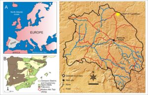
Figure 1. A) Geographical and geological setting of Fuentelsazin Europe, B) Spain (B), and C) in close-up, showing the geopark boundary, roads, and rivers.
The importance of this region in the history of geology and paleontological research in Spain cannot be underestimated. The earliest works date back to the mid-18th century, including various paleontological (and mineralogical) discoveries made by the Jesuit priest José Torrubia , which were published in his popular work "Apparatus for Natural History" (1754). This work is considered as the first treatise on Spanish paleontology, and it highlights the discovery of remains of various groups of marine organisms around the town of Molina de Aragon, among others. It also describes the finding of "a series of reddish coloured hexagonal crystals found around Molina de Aragón", the first find of the mineral aragonite, a polymorphic form of calcite, whose type locality is in the territory of the Geopark and received its name in honour of Molina de Aragón. A century later, Edouard de Verneuil (Anonymous 1851) described the discovery of several species of trilobites in the Pardos shales as Calymene tristani, Calymene arago and Placoparia tourmeminei. Furthermore, Verneuil and Collomb (1853) reported the first find of graptolites in the vicinity of Checa. In the late nineteenth century, the works of Salvador Calderón (1874, 1897, 1898) provided important data regarding the geology of the region, such as the discovery of tracks of Cheirotherium in the Triassic at Molina de Aragon, and they reported the first profiles of the Molina de Aragón Lias and the existence of Carboniferous successions. In addition, Carlos Castel (1878, 1881) reported fossil finds in Triassic sandstones in the vicinity of the town of Rueda de la Sierra.
The Molina & Alto Tajo UNESCO Global Geopark covers 77 municipalities, of which the most important town is Molina de Aragón. It occupies an area of 4,520 km2, making it one of the largest in the European Geopark Network, but is populated by only 10,370 inhabitants.
Alto Tajo was declared as a Natural Park the Castilla la Mancha government in 2000, in the southern part of the current park area. This declaration involved the establishment of a new development model based on tourism and sustainable use of natural resources and revealed the existence of a magnificent geological heritage that could be of interest not only to the scientific and educational community, but also to the public. In December 2005, a total of 2,368 hectares of the Sierra de Caldereros were recognized as a Natural Monument. Nine Geo-Routes were designed in the Natural Park and a Geological Guide was published in 2007, receiving an international award. Two other Geo-Routes were established in the northern part of the territory, around the Caldereros Mountains and the Mesa River Valley, when the whole territory became a UNESCO Global Geopark in 2015. This area has been the scene of numerous scientific investigations since the eighteenth century and the UNESCO Global Geopark updates its activity programme for school children each year, with guided tours and Environment and Geology workshops.
The Toarcian-Aalenian GSSP
The Global Boundary Stratotype Section and Point (GSSP) of the Aalenian Stage and, therefore, the base of the Middle Jurassic, was established in the town of Fuentelsaz (Fig. 1) by the International Commission on Stratigraphy (ICS) of the International Union of Geological Sciences (IUGS), during the 31st International Geological Congress in Brazil in 2000. Fuentelsaz is the first GSSP defined in marine sediments in Spain and is situated in the Molina-Alto Tajo UNESCO Geopark. It is the first of the five GSSPs defined to date in Spain, since it was proposed in 1994, accepted in 1998 and ratified in 2000. The relevance of this outcrop is based on its singularity, exclusivity, and national and international recognition by the scientific institutions in charge of studying the geological record of our planet. Recognition of the GSSP, and the Golden Spike installation ceremony took place in the summer of 2016, with the attendance of the President of the IUGS, Dr. Stan Finney, and a large group of scientists and political leaders in the area, as well as a large local population (Fig. 2).
The Fuentelsaz section is in the central sector of the NW–SE-trending Iberian Range, which is an intracontinental Alpine belt with Variscan basement and Mesozoic and Cenozoic cover. The Lower Jurassic sediments were deposited into a fault-bounded subsiding block, within in a N–S trending marine epeiric carbonate platform that was well connected to the open sea until the late Comptum Subzone (Fig. 3A). The facies patterns through the Fuentelsaz section are very similar to many other outcrops in the Iberian Range, where an important episode of extensional faulting has been recognized in the late Early Aalenian. Synsedimentary extensional tectonic activity is marked by a drastic increase in the net accumulation rate (12 m/Ma) during the latest Comptum Subzone, and is especially well recorded at the Fuentelsaz section (Barrón et al. 2010).
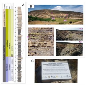
Figure 2. Golden Spike installation ceremony in the summer of 2016, showing the Toercian-Aalenian boundary marked in red, and IUGS President, Stan Finney (blue arrow).
At Fuentelsaz, the sediments of the Lower-Middle Jurassic boundary (Toarcian-Aalenian stages) are primarily marls and limestones, which can be remarkably thick in this area. The standard section spans 36 m (Fig. 3A). The section comprises marls with interbedded limestones forming an irregular rhythmic alternation, generally shallowing upwards in low energy environments of a subsidiary basin of a carbonate platform that was well connected to the open sea. Full oxygenation of the bottom allowed colonization of the sea floor by benthic organisms. The upper part of the section represents the establishment of more restricted environments. Marls are dominant in the upper part of the Pleydellia aalensis Subzone and in the Pleydellia buckmani Subzone. Carbonates become more important near the Toarcian–Aalenian Boundary.
In the Fuentelsaz section, the Toarcian–Aalenian Boundary is defined at Bed FZ 107 (Cresta et al. 2001). The boundary coincides with the first occurrence of the ammonite assemblage characterized by Leioceras opalinum and Leioceras lineatum, and the nannofossil Hexalithus magharensis is a secondary marker (Barrón et al. 2010), appearing first in Bed FZ 107.
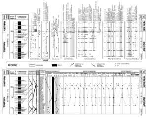
Figure 3. Fuentelsaz section and details of the Toarcian-Aalenian boundary, showing A) A synoptic section. B) Overview of the site and close-up of beds around the GSSP. C) The commemorative plaque.
Fuentelsaz presents one of the best ammonite records worldwide in this interval (Goy & Ureta 1987, 1991), which has made it possible to establish a high-resolution chronostratigraphic scale. This scale has been calibrated against the scales established by other fossil groups, including brachiopods, bivalves, ostracods, foraminifera, assemblages and palynomorphs and calcareous nannofossils. Likewise, studies have been carried out on sequence stratigraphy, paleomagnetism, mineralogy of the clay fraction and carbon and oxygen isotopes, with the aim of finding sedimentological, magnetic and geochemical signals in order to make correlations and the calibration of the reference scale (Goy and Ureta 1991; Goy et al. 1994; Cresta et al. 2001).
Formally, the GSSP of the Aalenian Stage is located 0.5 km to the north of Fuentelsaz village, in the north-east of Guadalajara province, Central Sector of the Castilian Branch in the Iberian Range; about 170 km ENE of Madrid and 30 km north of Molina de Aragón. The GSSP is located at a latitude of 41°10'15" N and a longitude of 1°50' W. Fuentelsaz is a tiny village of just over 100 inhabitants. The GSSP section is made up of two outcrops located in the vicinity of the urban nucleus, at the foot of the hill called Cabeza Quemada (Fig. 1).
There is no doubt about the importance of GSSP sites for the international geological research community; but can they be made interesting for local people in the area and for visiting tourists?
Geotourism and Geotrail Potential
The mission of a geopark is to conserve, promote, and develop the geological heritage within its borders. In this context, the fact that the GSSP for the base of the Aalenian is located in the Geopark of the Comarca de Molina and Alto Tajo becomes especially relevant. Scientific activity in the fields of geology and paleontology has been promoted in the area since the completion of the Geological Map of Spain (Goy & Comas-Rengifo 1983), resulting in numerous studies (Goy & Ureta 1991; Goy et al. 1996; Ureta 1985). Also, local growth based on sustainable development has been a priority (Carcavilla et al. 2016), with engagement at national, provincial and local level. The Geopark Territory is one of 13 priority zones to be boosted by rural development grants, with funds to be allocated for Geotourism promotion and rural development. The most remarkable of these was the FORCOL (Regional funds for local cooperation) programme during 2010–2012, when 54 million euros were invested in developing the productive rural economy and infrastructure.
The Museum of Molina is the focus for integration of natural and cultural heritage in sustainable development through four initiatives:
(1) Inventories of the geological heritage of Molina and Alto Tajo in terms of the scientific, educational, recreational, anthropological, and other criteria.
(2) Geoconservation throughout the protected areas of the Geopark, but also in the rest of the region. In places, to complete the effectiveness of the national and provincial nature protection legislation, it has been necessary to construct physical barriers, such as at the Dropstone of Checa. The Museum of Molina Cultural Association promotes geoconservation measures such as this, and significant progress has been made in the protection of the fossil forest of the Sierra de Aragoncillo and Fuentelsaz GSSP.
(3) Support for research at many national institutions, including the Spanish Geological Survey (IGME), Consejo Superior de Investigaciones Científicas (CSIC), Faculty of Geology of the University Complutense of Madrid, Faculty of Geographical History de la University Complutense de Madrid, University Politecnic of Barcelona (UPB), Institute Pirenaic of Ecology, University of Zaragoza, University of Alcalá de Henares (UAH), Centre UCM-ISCIII of Human Evolution and Behaviour, and the Faculty of Geography of University Autonoma of Madrid.
(4) Dissemination through the Association of Friends of the Museum of Molina establishes bridges between the scientific community and the local population. This work takes the form of lectures, exhibitions and field trips that make scientific discoveries in the region accessible to the population. The Museum issues several publications, including the Nautilus Magazine, annual scientific publications, and the paleontological Guide to the Middle Ordovician Trilobites of Castilla - La Mancha and collaborations on regional geology in the book Geology of Guadalajara (Calonge and Rodriguez 2008).
The Fuentelsaz GSSP stratotype currently plays an important role in the pursuit of three objectives (Ureta & Canales 2017):
(1) the scientific research carried out in the stratotype continues to be the driving force behind its importance worldwide as a reference on the chronostratigraphic scale.
(2) The Fuentelsaz Town Council and the Geopark are collaborating to carry out geoconservation and dissemination initiatives including guided and informative tours, talks, publication of brochures and other tourist and dissemination materials, installation of information panels and signage elements on the site aimed at the general public and the local population, rehabilitation of the old waste dump area to transform it into a panoramic viewpoint of the stratotype, and importantly, the creation of a museum-interpretation center with the objective of explaining the relevance of the cultural and scientific heritage of this town and of the stratotype (Fig. 4) (Martinez & Monasterio 2017).
(3) It is expected that such actions should promote the development of cultural tourism focused on the importance of preserving heritage, which activates the economic, social, and cultural growth of these depressed rural areas, which have an uncertain future.

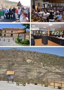
Figure 4. Lithofacies, sequence stratigraphy, magnetostratigraphy, geochemistry, mineralogy and paleontological record of selected taxa within studied fossil groups in the Toarcian-Aalenian transition and Fuentelsaz GSSP.
Geoconservation
One of the requirements of the ICS in designating a GSSP such as Funetelsaz is that the administration guarantees permanent protection of the site. The Fuentelsaz stratotype is protected as a Natural Monument (Goy et al. 2004; García-Cortes et al. 2017), which is defined as “geological formations, paleontological deposits and other natural elements that gather a special interest due to the singularity or importance of their scientific values” (Law 9/1999 of May 26 on the Conservation of Nature of Castilla-La Mancha). Initially, Fuentelsaz was declared as a geosite of international relevance by the Geological and Mining Institute of Spain, its legal protection being warranted by the National Law 42/2007 on Natural Heritage and Biodiversity. Thanks to the collaboration of different institutions, the scientific community, and the local population, the GSSP of Fuentelsaz was finally declared a Natural Monument in 2017.
Several actions have been planned to protect the Fuentelsaz stratotype, considering the outcrop’s small extent (85 hectares) (García-Cortés et al. 2017), including:
(a) To set up a protection perimeter. The site is large and on a slope (Fig. 2), so members of the public rarely climb over the site, but such a measure could be considered in case of degradation risk.
(b) To install a surveillance system so that Environmental Services can monitor the conservation of the site.
(c) To regulate the site’s uses and activities, specifying which activities are allowed, which are subject to authorization, which are prohibited, and which are enforced by the Fuentelsaz City Council.
(d) To facilitate and coordinate the research work of different research teams, in collaboration with the Scientific Committee of the Geopark, so that they authorize, control, and monitor the investigations carried out in the area.
(e) To continue ongoing initiatives for the dissemination of the scientific and heritage values of the Fuentelsaz stratotype. Interpretive panels have been installed to raise awareness among the public and the local population of the importance of heritage conservation. On June 28, 2016, on the placement of the “golden spike” at the stratotype, information panels were presented in the Fuentelsaz museum-interpretation and in the outcrop’s panoramic viewpoint (Fig. 5).
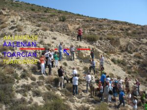
Figure 5. Scenes at Fuentelsaz. Top right, Mayor of Fuentelsaz, President of the IUGS and local authorities showing the “golden spike” to the media. Top left, GSSP proclamation ceremony in the Fuentelsaz assembly hall. Middle left, Exterior of the Museum-Interpretation Centre of the GSSP of Fuentelsaz. Middle right, Detail of the interior of the Museum-Interpretation centre. Bottom, Viewpoint and explanatory area of the GSSP of Fuentelsaz.
Acknowledgments
This research has been developed with the support of the CGL 2015-66604 Project (MINECO Spain), UCM Research Group: Mesozoic Biotic Processes (PBM); and the Spanish Geological Service (IGME) Project 2457: Improvement of the knowledge of the geological heritage of Castilla-La Mancha. The authors acknowledge the support of the association of Friends of the Molina Museum. The paper was completed with background information from the official geopark websites (editors).