Introduction
Due to the increase in anthropic activities that permanently alter the natural environment (Haff 2003; Iordache et al. 2020), it is more and more important to educate people about the importance of preserving and conserving the natural environment. Therefore, both biotic and abiotic (e.g., rocks, fossils, soils, landforms) elements of nature must be protected to ensure their use for this and future generations. These abiotic components are also recognized as geodiversity, which is defined by Crofts et al. (2020) as “the variety of rocks, minerals, fossils, landforms, sediments and soils, together with the natural processes that form and alter them”.
Geoparks can act as references for territories that promote the conservation of their abiotic elements through sustainable development and educational strategies. The concept of geoparks initially emerged in Europe in the 1980s, and it has been evolving since then (EGN 2000). In 2000, the European Geoparks Network (EGN) was founded with four members, the German Gerolstein District Geopark (later renamed Vulkaneifel Geopark); Réserve Géologique de Haute-Provence in France; Petrified Forest of Lesvos in Greece and Maestrazgo Cultural Park in Spain. After this step, several further initiatives were started around the world (Brilha 2018). The UNESCO Global Geoparks (UGGps) label was created on 17 November 2015 and represented a recognition of the importance and need to manage the outstanding geoheritage of a given area. According to UNESCO (2021), geoparks are “territories where sites and landscapes of outstanding geological features are managed with a holistic concept that involves protection, education and sustainable development of local communities”. And, even if not mentioned, geomorphological features are an important part of the value and attractiveness of some Geoparks (Sá & Rocha 2020; Vieira et al. 2020). Therefore, these territories are excellent places to develop touristic activities, such as geotourism which is defined as a format of tourism promoted in natural areas, focusing specifically on the geology and landscape of the site, and promoting conservation of the geodiversity aligned with an understanding of the earth sciences through aesthetic appreciation and learning (Newsome & Dowling 2010).
The development of educational activities is one of the essential requirements for the UGGp label, where the candidate must indicate the progress and success of education activities (Nascimento et al. 2022). Therefore, all UGGps must develop and apply different educational initiatives for all educational levels to promote links between geoheritage and other kinds of heritage (Operational Guidelines for UNESCO Global Geoparks), and contribute to raising awareness of geological, cultural and other natural heritage (UNESCO 2021). Based on that, education activities offered to schools may be developed by a dedicated educational department, partner organization or geopark staff (Catana & Brilha 2020).
Geoscience education for sustainability is not only a fundamental pillar of UGGps (Catana & Brilha 2020), but also a type of education that contributes to providing people with adequate knowledge about natural processes that have shaped the Earth and understanding how human actions can have impact at local and global levels (Locke et al. 2012). Geoparks are excellent territories to promote geoconservation, and despite not being included in any category of protected area, some geoparks may have some protected areas within their boundaries. For example, the Araripe UGGp includes nine protected areas in its territory (Cabral & Mota 2010), and the Molina-Alto Tajo UGGp was created in the surroundings of the homonymous national park (Martínez et al. 2011).
The International Union for Conservation of Nature (IUCN) defines a protected area as “[...] a clearly defined geographical space, recognised, dedicated and managed, through legal or other effective means, to achieve the long term conservation of nature with associated ecosystem services and cultural values [...]” (IUCN 2008). Since 2008, IUCN has recognized the importance of including geodiversity in nature conservation actions through resolutions that place geodiversity on the same level of concern as biodiversity (Díaz-Martínez et al. 2017). Geoconservation, a branch of geosciences, has as its main purpose to conserve the geodiversity of the planet, so that the formation processes and natural evolution of the features are maintained (Sharples 2002, Henriques et al. 2011).
However, although IUCN has recognized the importance of geodiversity and geoconservation, this does not imply that the wider nature conservation community is engaged in making geoconservation effective in protected areas. Therefore, practical actions are still needed to improve the engagement of people (Gordon et al. 2018), such as educational actions focused on geoconservation, for example. In connection with geoparks, several efforts have been undertaken to promote the sustainable use of geodiversity and geoconservation actions in protected areas worldwide (Crofts & Gordon 2015; Gordon et al. 2021; Štrba et al. 2020).
From this perspective, both protected areas and UGGps can promote better public understanding and raise awareness of the benefits of geoconservation actions to nature and society (Gordon et al. 2021). But in contrast, several protected areas were created based on biodiversity value (Gordon et al., 2018) and consequently the educational actions developed by these areas are focused mainly on these elements. Of course, the educational materials should also reflect the geodiversity of these areas; equally, educational activities promoted by UGGps should also refer to biodiversity and environmental education (Catana & Brilha 2020), as well as archaeology, history, and local cuisine, if appropriate.
Based on these fundamentals, protected areas have great potential to stimulate local conservation awareness through educational activities. Further, because not all areas with exceptional geological features will become geoparks, protected areas in the world have been one of the only mechanisms for protecting these elements in several territories. This study aims to i) identify the educational materials developed by UGGps, ii) classify these materials by geoscience topics and typology; and iii) carry out a preliminary analysis on the potential of these educational materials to be adapted to the context of protected areas. For this purpose, a comparative analysis was performed with the IUCN's categories for geoheritage interest.
Methods
Our method involved five steps:
- i) Survey of UGGp Websites. Data on the location and recognition date of the geoparks was examined on the UNESCO official website (https://en.unesco.org/global-geoparks/list). Then, these data were organized in a database.
- ii) Selection of educational materials on UNESCO Global Geoparks We looked at the official websites of each UGGp and considered three criteria for the educational materials, which had to: (a) be written in Portuguese, Spanish or English (for geographic and cultural reasons); (b) fully describe the educational materials including topics, methods of application, school grade (when applicable) and whether they can be used in the teaching-learning process, and (c) be free of charge. Educational material means any resource, action, or program with a pedagogical purpose. This step was performed in March 2021, so we do not include materials uploaded to the websites after this date.
iii) Review of the literature on educational programs and activities. Systematic searches on the Scopus and Google Scholar databases were carried out using the keyword ‘education’ plus the name of each UGGp found in step (i). Then, scientific papers were selected based on (a) detailed description of educational actions and resources, (b) the languages (defined in step ii.a), and (c) focused on education or educational use of geoheritage.
- iv) Classification of educational materials in geoscientific categories and topics. The materials were analyzed and classified according to groups based on their main purpose and characteristics. The identification and classification of the main topics were synthesized in keywords and associated geoscientific topics (Fernández Álvarez 2020) (Table 1).
Table 1. Keywords and geoscientific topics associated with the main content of the educational materials. The left column includes some keywords that compose the geosciences topics in the right column.
Keyword | Geosciences topics |
Volcanoes - Igneous rocks - Magma and lava - Igneous structures | Igneous rocks |
Sedimentary rocks - Diagenesis - Sedimentary structures - Sediments and sedimentation | Sedimentary rocks |
Metamorphic rocks - Metamorphism - Metamorphic structures | Metamorphic rocks |
Fossils - Ichnofossils - Biostratigraphy - Palaeontology | Palaeontology |
Water quality - Water cycle - Groundwater - Surface water | Hydrology/Hydrogeology |
Orogeny - Plate tectonics - Earthquakes - Deformation - Folds - Fractures - Faults | Tectonics and structural geology |
Geochronology - Palaeomagnetism - Solar system formation - Life origin | Geological time and Earth history |
Climate change - Geohazards - Land use - Landslides | Environmental changes and hazards |
Soil - Processes of soil formation - Soil genesis | Pedology |
Landforms - Morphology | Geomorphology |
Ore - Rock buildings - Economic deposits - Mining | Natural and energy resources |
Erosion - Rock formation - Atmosphere - Transport - Sedimentation | External Earth dynamics |
Earth materials - Rock cycle - Geological formations - Earth’s structure - Minerals - Rocks | Earth materials |
Geoconservation - Geoheritage - Geodiversity - Geosite | Geoconservation |
Glaciation - Glacial processes and products | Glacial processes |
Karstic environments - Caves - Karstic processes | Karstic environments |
Map - Cartography | Cartography |
Geologists - Geological career | Geological career |
- v) Comparison with the topics described in Crofts et al. (2020). In order to compare potential themes and identify gaps, the themes and topics in geosciences by which the educational materials were classified were confronted with the geoheritage interests verified for protected areas.
Results
Survey on Geopark Websites and Papers
A total of 162 UGGp websites, located in 44 countries, were analyzed. Among them, 34 (21%) had websites that were inactive, under maintenance or in construction, 29 (18%) had no educational materials, and 64 (39.7%) did not describe educational activities in detail (materials are merely mentioned or there are only contacts for scheduling). On the other hand, 34 have detailed educational activities and resources; however, 19 (11.8%) are written in languages that do not fit the pre-established criteria (Fig. 1). By the end of the survey, a total of 16 (9.3%) UGGp websites (distributed in 7 countries) were analyzed regarding their educational materials (Fig. 2).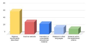
Figure 1. Synthesis of educational materials on the UNESCO Global Geoparks websites.
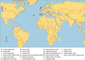
Figure 2. Geographic distribution of UNESCO Global Geoparks with educational materials on their websites or in published scientific papers.
Some of the websites provide educational resources for download. However, in certain cases the link directs the visitor to an external website, where such activities are often sold. Folders usually have superficial descriptions of educational activities, so such materials were not included in our analysis. Workshops and training courses for teachers and the local community were also found. However, only some details are provided, and without information on geoscientific content.
A total of 22 scientific papers related to Geopark educational programs were identified (referring to 15 geoparks in 13 countries). Of these, seven were analyzed since they fulfilled the pre-established criteria (Appendix A). Only Arouca UGGp in Portugal has both educational materials on its website and a paper describing its educational programs and educational centers (Henriques et al. 2012). The other papers describe educational activities related to geotours (Maltesics 2020), geoitineraries and geotourism (Santangelo et al. 2020), field trips and educational centers (Zouros et al. 2011; Ren & Wang 2017), educational programs (Fassoulas et al. 2007) and games (Nunes 2018).
Papers describing only aspects of the Geopark or mentioning the educational programs and educational center, but without enough information on the educational programs and activities, were not considered.
Analysis of Educational Materials
Several types of educational materials (Fig. 3) and geoscience topics were found on the UGGp websites and the analyzed papers (Fig. 4). The materials, resources and activity proposals were grouped according to their main purpose and characteristics (Appendix B) and they are described below. The geoscience topics were considered in each example individually, and each activity can have more than one topic.
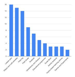
Figure 3. Quantity and typology of activities found on UGGp websites.
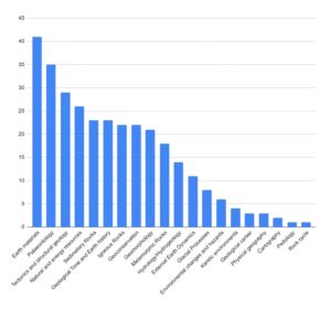
Figure 4. Quantity of geoscientific topics addressed in the educational activities.
- Lesson Plans
By definition, a lesson plan describes what the students need to learn and how the teacher will implement this lesson in an effective way. It can include basic elements such as learning objectives, activities and assessment of the student's understanding (Centre for teaching excellence SMU). In our survey, most materials were focused on teachers (Fig. 5A, B) and planned to take place both in the classroom and in the Geopark environment. A total of 15 lesson plans were found in the Tumbler Ridge (Canada), Burren & Cliffs of Moher (Ireland), Rokua (Finland) and Marble Arch Caves (Ireland) UGGps. All plans describe the objectives, curriculum links, necessary materials, prior teacher preparation, background information containing tips and main topics covered, how to carry out the activities, supporting materials (e.g., maps, figures and images to print), evaluation and extra activities.
The Tumbler Ridge UGGp (Canada) provides its lesson plans in separate sheets designed for teachers (10), students (7) and support materials (4). They were designed to be implemented outdoors, but an introductory step (in the classroom) and adaptation to the indoor environment are suggested.
Because of the required materials (such as sandpaper, dilute HCl acid and cord) for the activity, the Burren & Cliffs of Moher geopark resources (4) are focused on the classroom environment, providing supplementary material for introductory classes and closures.
The Rokua Geopark lesson plan is targeted at students from 9 to 15 years old. In this activity, the teacher builds a timeline with the students. After that, the teacher addresses the meaning of geological processes (events that took place over geological time) and related formations. The class ends with a brief introduction to the Ice Age: what it means, when it occurred, and what traces it left behind. This activity has been proposed for indoor conditions, but it can be adapted to other environments.
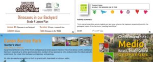
Figure 5. Examples of educational materials produced in UNESCO Global Geoparks. A) Lesson plan of the Tumbler Ridge Geopark (https://www.tumblerridgegeopark.ca/); B) Lesson plan of the Burren & Cliffs of Moher Geopark (https://www.burrengeopark.ie/); C) Field guide designed for teachers of the Marble Arch Caves Geopark (https://www.marblearchcavesgeopark.com/); D) Textbook of the Villuercas-Ibores-Jara Geopark (https://www.geoparquevilluercas.es/).
On the Marble Arch Caves Geopark website, a lesson plan is focused on developing a geological map of the backyard with the children. It may be performed outside a school or in a park or garden. It contains two pages with basic information.
- Field Guides
Field guides in the earth sciences may have two components, the first being an introduction to the local geology and the second a conceptualization of the geological history using stops and itineraries (Donovan & Harper 2005; Mory et al. 2005; Mylroie & Carew 2010).
Six field guides have been developed by the Marble Arch Caves UGGp. They contain fact sheets (Fig. 5C) with topics to be assigned before the visit, helpful equipment, and other relevant information to help the teacher plan the Geopark visit. In addition, a student sheet with tasks and questions that students can address during the field trip is also included. These questions can help students notice the main differences between rocks or even learn how to sketch a rock exposure.
The materials on the North-West Highlands Geopark website (3) follow the same structure. Both intend to help and support field trips within their boundaries, providing support to teachers and students by including the geopark environment in their educational actions. In addition, they provide information such as location, useful equipment and site descriptions that visitors can use to locate themselves and take the required precautions.
- Textbooks
According to the Britannica Dictionary, a textbook is: “a book about a particular subject that is used in the study of that subject especially in a school”. In this sense, we consider textbooks as any kind of material with detailed explanations of concepts that help people understand a specific subject, in this case, geoscience topics. In this case, we include any kind of didactic or pedagogic work that can include usually short, illustrated informative documents of any size.
The textbooks found in this survey are usually developed by geopark staff and contain descriptions of the geosite, the geological history of the area, and, sometimes, the social and cultural context of the territory (Fig. 5D). This involves conceptualizing geological history, explaining geoscientific concepts involved in landscape formation, and includes several figures and illustrations that can help identify the content. These materials highlight the specificities of their territories. For example, the Naturtejo UGGp in Portugal introduces topics about the Ichnological Park of Penha Garcia and the fossil route, where the concepts of fossils and ichnofossils are explained, besides presenting information about the routes. In this textbook, several questions and answers, usually directed to the guides, are displayed. These materials focus on giving background information to teachers and students, including the elements of the geoparks in their lessons to support them in field trips in the geopark.
The Azores UGGp in Portugal has textbooks (5) with guidelines and explanations about the volcanoes in the region. Such materials were considered textbooks due to the richness of the information and the descriptions of the geoscience concepts. The materials are divided into a book for each educational cycle (secondary, 1st, 2nd and 3rd cycle) and the other is a children's book that can be used in the classroom to complement the lessons. However, what distinguishes this material is the fact that each book seeks to address the target audience directly.
The Villuercas-Ibores-Jara UGGp textbook is very rich in terms of illustrations and figures. It also presents the geosites and other elements of the territory as examples illustrating broad concepts.
- Geoitineraries and Geotours
These resources are focused on the use of geosites to develop a geotouristic itinerary by explaining geological processes and materials involved in their formation, and even the geological context of the region. We understand geotourism as a sustainable form of tourism that, according to Newsome & Dowling (2006), focuses on the “geology and geomorphology and the natural resources of landscape, landforms, fossil beds, rocks and minerals, with an emphasis on appreciating the processes that are creating and created such features''.
Geotours were found in the papers of Santangelo et al. (2020), Maltesics (2020) and on the Sobrarbe-Pirineos UGGp website. The materials present basic information, such as the main geological concepts which use features of the territory as examples, description of the stops, curriculum connections and details about the activity step-by-step. In all of them, the physical environment was used as a resource to discuss the route, which is associated with a line of reasoning to explain the key features of the geopark. Further, with the exception of the Sobrarbe-Pirineos material, the geoitineraries were described in terms of development and application, with enough information to adapt the activity to other territories and educational contexts.
Two types of educational materials about three geoitineraries were found on the Sobrarbe-Pirineos UGGP website, one intended for teachers and the other for students. The material for teachers has suggestions on how to carry out preparatory activities in the classroom, as well as questions similar to those in the material intended for students. In the student material, there are questions with spaces for students to report their observations and investigations along the itinerary, aimed to enrich their experience of the field. These materials were the most detailed that we saw because they described the itinerary and explained the key concepts. In this sense, in addition to being an itinerary description, they can be used in the field or in classroom lessons.
Maltesics (2020) presents two geotours in the Bakony-Balaton UGGp (Tihany Anniversary Geotour and Geotour of Felsőörs) and describe the geotours as a special form of education in the North-Balaton region of Hungary. The strengths, flaws, and prospects of the region are displayed, as well as additional tourism potential in rural and urban locations. In addition, the author describes geographical processes and concepts and the curriculum links associated with each stop, passing through diverse landscapes, geosites and historical sites.
Santangelo et al. (2020) present a proposed geoitinerary through the Cilento, Vallo di Diano and Alburni UGGp, through some of the coastal areas with interesting geological elements. The method of selecting sites and assessing their educational use are also described. The author uses the sites to explain concepts such as climate change and evolution of the rocky coast, using several figures and diagrams to illustrate the processes involved.
- Educational Programs
Programs focused on formal school requirements are reported in papers on the Lesvos Island, Psiloritis, and Basque Coast UGGp websites (Fig. 6A, B). Zouros et al. (2011) described how active faults can help raise awareness of seismic risks in the Lesvos Island Geopark. The educational activity “Earthquakes: natural processes and hazards on planet Earth - Living on a seismic island” was developed by the Natural History Museum of the Petrified Forest of Lesvos to familiarize students with earthquakes, active faults and seismic hazards.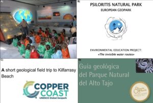
Figure 6. Examples of educational programs, field trips and geological guidebooks in UNESCO Global Geoparks. A) Students in the educational program on earthquakes at the Natural History Museum of the Lesvos Petrified Forest Geopark (Image from Zouros et al. 2011). B) Educational program on the invisible water routes at the Psiloritis Natural Park Global Geopark (Image from Fassoulas et al. 2007). C) Copper Coast Geopark field trips (Source: http://www.coppercoastgeopark.com/). D) Molina - Alto Tajo Geopark guidebook (Image downloaded from http://www.geoparquemolina.es/).
Fassoulas et al. (2005) describe a geopark education project (Psiloritis UGGp) targeted at elementary and middle schools. It describes the steps of the activities and the methodology applied to understand the water processes that interact with carbonate rocks to form natural landscapes and ecosystems, such as plateaus, canyons, caves and springs.
The educational programs of the Basque Coast UGGp (2) are developed in three phases (contextualisation and previous exercises; fieldwork; fulfilment of tasks) and describe information such as program objectives, fundamentals, and methodology applied. One of the programs is designed for elementary school students (Programa didáctico para conocer los fósiles del museo Nautilus de Mutriku) and the other for middle school students (Programa didáctico para conocer El Flysch de la Costa de Zumaia). In the latter, problematic situations are available to work on the proposed concepts.
- Field Trips
We include here any material relating to field trips that describes the activity, the stops, the educational purposes and suggestions on how to carry out the activity, or the curriculum links. These materials were considered different from geoitineraries in terms of access and format, which in the field trips is for an educator or guide, whereas in geoitineraries the public can follow the document without a guide. Field trip materials were found on the Naturtejo and Copper Coast UGGPs websites and in papers about the Arouca and Yuntaishan UGGPs.
The Naturtejo UGGP website includes their field trips (8) in a sheet format that are intended for each school cycle. Such materials include the subjects that can be included, duration, curricular units, contents covered and approaches, such as suggestions of places or elements of the site. Each sheet also includes suggestions for activities after the field trip. In addition, a more detailed description of field trips is provided in the Naturtejo educational program guide.
The Copper Coast website (Fig. 6C) offers sheets that start with an introduction to geological concepts and environments intended for field trips. The sheets contain questions, gaps to be filled with information seen on the site, and quizzes for the final grades of elementary school. For the initial years, there are sheets containing tables intended to draw the elements seen in the field, as well as gaps to fill in with simple information such as colors observed in the sand and the uses for copper.
The field trips of the Arouca UGGp are described by Henriques et al. (2012), who describe an educational intervention carried out with 16-year-old students from a high school in Portugal. The field trip was based on a three-phase constructivist model (Orion 1993), by applying cooperative work strategies. The resources used and the main topics worked on by the students are described in detail. At the end of the activity there was a survey to evaluate the activity and the use of the geopark as an educational resource.
Ren & Wang (2017) designed a plan for middle school students on a physical geography field trip in the Yuntaishan UGGP. The paper reviews the geological, geographic and geomorphological resources, fauna and flora, water and soil resources of the Yuntaishan Geopark and evaluates its role as an educational resource for physical geography field activities in high schools. In addition, the paper highlights the curriculum content categories for high school physical geography field trips, linking each natural resource to curriculum contents and how to achieve the core skills and competencies expected in the curriculum.
- Guidebooks
Guidebooks are generally used to complement and assist field activities. In this survey, they differ from field guides in terms of detailing the different aspects of the territories with several illustrations and images. The contents are addressed using elements in the field, with details of their meaning. In terms of educational potential, it is possible to use these materials as interpretative resources, encouraging local scholars and residents to know more about the geoheritage that is part of their daily lives.
On the Molina-Alto Tajo UGGp website, a guide was planned for the public, with detailed descriptions of the local geology and geosites, and with figures and maps for easy interpretation (Fig. 6D). The book is divided into chapters describing general geological concepts, the geological history of Alto Tajo in six episodes (from Paleozoic to Quaternary), the geomorphology of the region and concepts in geoconservation. The geological routes are described in detail, identifying all the stops, what can be observed in the geosites, maps, general characteristics of the routes such as walking time, distance, and recommendations.
A guidebook about the Naturtejo UGGp educational programs was also found. This material was considered a guidebook because it contains detailed descriptions of field trips that can help teachers. Text about the origin of the geopark, descriptions of the geodiversity and the geological history, and a geological map are also available. It can be used as an educational resource in field trips and in pre-field classes.
Rokua displays on its website a guide intended for kids, presented by the geopark mascot (a mammoth) that talks about the geological history of the place (from the ice age to the present day) and how the landscape has changed over time. A trip through geological time is made using the geopark's geosites. This material can be used to support children’s field trips and also as a complement to formal education through figures that illustrate geological processes.
- Play and Craft Activities
Play materials include word-search activities with geoscientific and geoparks contents, coloring activities of extinct animals from different geological periods and puzzles containing paleontological figures and landscapes of geoparks. The Sobrarbe-Pirineos UGGp website provides four puzzles in a single document containing information such as objectives, knowledge area, target audience (students from 3 to 6 years old), curriculum content, preparation phase, forms of evaluation and information to develop the activity. On the Naturtejo UGGp website, activities such as "find the difference" or "find the words" are associated with paleontology, rivers, minerals, rocks and past mining issues (Fig. 7A).
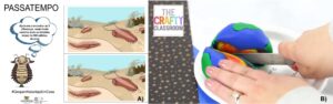
Figure 7. Examples of play and craft activities in UNESCO Global Geoparks. A) Play activities from the Naturtejo Geopark website (https://www.naturtejo.com/) and B) craft activity from the Marble Arch Caves Geopark website (https://www.marblearchcavesgeopark.com/).
The Estrela UGGp has a book of activities designed to work at home during quarantine (COVID-19). It contains hobbies, coloring and cutting activities, word searches, images and texts to fill in the blanks with the name of rivers, connect the dots and the maze game. These activity books are normally adapted according to the grade.
The activities on Marble arch Caves UGGp (2 craft activities) involve building Earth structures, with children invited to use modeling clay of different colors to make a terrestrial globe. To finish, the structure is broken in halves showing the different features such as core, mantle and crust. There is also an activity to make cookies in trilobite shapes that can be done at home with adult supervision or in the classroom with teachers (Fig. 7B).
- Inquiry-based Learning Activities
The structure of these materials is like a lesson plan, but differs in terms of approach since they contain questions to encourage students to find the answers by themselves. These activities can be used in several educational contexts such as geopark, protected and conserved areas and even museums. Further, the material is structured as a script to be followed by teachers. It also differs from worksheets by suggesting questions that can guide a reflection on the content, where students build their knowledge by themselves.
These activities were also found on the English Riviera Geopark website and aimed to stimulate students’ sense of investigation, leading them to learn while observing and investigating their local environment. Children can study and explore content such as geological time and cave formation through key questions in these activities. This material is a draft plan that can be adapted by schools. It contains anticipated learning objectives and outcomes, plus a variety of learning and teaching activities driven by key questions related to curriculum progression. There is also text about the context and explanations of how to proceed with the activity before, during and after the visit. For example, in the activity entitled “EYFS Enquiry 1” the first question to students is: “has this place always been like this?” Pupils can then explore the area with this question in mind, perceiving what changes took place through geological time.
- Activity Textbooks
These materials are textbooks with suggested activities and questions that can help students and teachers to explore the associated material. A large number of suggested activities mean that the material is no longer just a textbook, but didactic activities became the main focus.
The activity textbook about the Villuercas-Ibores-Jara UGGp (Fig. 8) presents in chapter 1 a detailed description of the objectives, justification and methodology used in the educational program and other information about the programs and activities. Chapter 2 covers information on objectives, contents covered and evaluation criteria. The proposed activities are field trips and visits to educational and historical centers.
Material of this kind was also found on the Courel Mountains UGGp website and includes topics such as the geology, geomorphology and history of the region, together with text and illustrations about architecture and ancient industries. In addition, investigation activities, experiments and questions about the texts are distributed throughout the book, which help students to absorb the concepts.
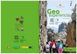
Figure 8. Villuercas Ibores Jara Geopark activities textbook cover (Image from: https://shre.ink/hmT).
On the North-West Highlands UGGp website, there is some material intended to support teachers and students who are visiting the geopark, or other regions with a similar geological context. The activities package helps in meaningful learning about earth science concepts using the region's sites as a resource. The activities have geological maps in addition to the location of the sites that can be visited or viewed by Google Earth. Some extra activities are suggested, as well as links to complementary resources.
- Games and Experiments
Ubaydullayev & Azimov (2020) define didactic games as: “[...] activities in which more than one person interacts with each other, that is, the process of learning takes place in the form of a dialogue based on dialogue or with the interaction of teachers and students”. Nunes et al. (2018) present a game with this purpose in their paper about the fossils of the Araripe UGGp (Fig. 9A), but it was not developed by the Geopark staff. The game is based on “PERFIL®” and it aims to bring the local community closer to the Araripe Geopark. There are cards about fossil plants collected in the Araripe sedimentary basin and the game is played by groups with the help of a board. The game may be downloaded from an independent website, "http://luisnune3.wixsite.com/jogosdidaticos" where information on how to apply the material is provided.
In addition, some didactic experiments focus on enabling a dynamic approach to the content taught in the classroom with practical operation and on facilitating the teaching-learning process (Battisti et al. 2019). With this purpose, there is an experiment about volcano eruptions based on home learning on the Marble Arch Caves UGGp website (Fig. 9B). This is a volcano making activity using homemade materials, such as disposable cups and plates, and vinegar that can be done at home or in the classroom with the help of parents or teachers.
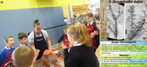
Figure 9. Examples of games and experiments in UNESCO Global Geoparks educational activities. A) Violent Volcanoes Experiment from the Marble Arch Caves Geopark website (https://www.marblearchcavesgeopark.com/). B) Card from the Araripe Geopark paleontological detective game (Image from: https://luisnune3.wixsite.com/).
Discussion
Assessment of the Educational Materials
Our results indicate that educational materials developed in the UGGPs have great potential to be applied more widely, including in protected areas, since their trained staff present geoscientific topics in an educational form. The different kinds of materials show great potential to contribute both to geosciences and environmental education, helping to raise awareness of conserving geodiversity and geoheritage. The designs of some activities follow the structure of a classroom preparation step, a field activity, and a completion step (Fassoulas et al. 2007; Henriques et al. 2012). These step-based educational activities are excellent for introducing students to the environment and its elements, harnessing their enthusiasm for being in new environments. Either in geoparks or in protected areas, this is a fundamental educational structure (Orion 1993) that can help and facilitate field work.
Some resources provide outstanding support for teachers. In lesson plans, for example, components such as clear goals and objectives for student learning, teaching-learning activities, and establishment of strategies to test and check the student's understanding of the content can increase the chances of success (Sharofovna & Qahhorovna 2022). This dominant model is a rational-linear framework discussed by Tyler (1949) offering a stepwise structure that is common in lesson planning. In terms of utility, lesson planning can give security to teachers in being prepared for unpredictable situations in the teaching-learning process (Farrell 2002). In this sense, the UGGp lesson plans can give teachers a model to follow in introducing geoscience topics in their classes, even if the teachers do not have an earth sciences background.
Field guides can also be excellent tools to encourage teachers to carry out field trips, as they contribute to overcoming panning difficulties. Further, these activities can increase students’ interest in geology and foster their active participation, which optimizes the teaching-learning process (Gomes et al. 2016). In the context of protected areas, field guides can encourage the educational use of geodiversity and provide material and contents for educators to include these elements in their classes. Student experiences in geoparks or protected areas can educate them in sustainable behavior as well as facilitate their learning. Further, this kind of activity can make the learning process more significant (Orion & Hofstein 1991) and play an essential role in teaching students about regional geodiversity and the complexity of Earth dynamics.
In terms of formal educational materials, textbooks are key (López-Valentín & Guerra-Ramos 2013), and those analyzed included many geoscientific contents. In many countries, geology does not feature in formal education requirements, so these materials have added importance in sometimes being the only opportunity for students to explore the subject (Brusi et al. 2016). For this reason, teachers with biology, chemistry and geography backgrounds often do not have the required knowledge to teach such topics (King 2008). Therefore, when this material is designed to be used by non-specialists it must introduce the basic geoscientific concepts with clarity and with links to other scientific fields (Stewart & Gill 2017).
When dealing with educational programs, we verified that all of them involve a field trip. The materials also describe a preparation unit involving contextualization and introduction to the topics and steps of the activities. Further, they use the geological elements of their territories as an educational resource, giving examples of how to use them in educational programs.
Geoparks have great potential for implementing field trips involving geoscience topics for both formal and non-formal education (Fornaro & Fernandes 2018). They can greatly influence the schools that use the geopark for education through their practical activities and field trips (Brilha 2009) as well as the desire by the wider population to preserve their local geoheritage. Therefore, field activities can be considered a key factor for the success of conservation actions, which depend directly on the awareness of local communities (Muzambiq 2021). Indeed, many protected and conserved areas are used for this purpose, but the geodiversity of the area is only rarely considered.
Enquiry-based learning activities show good potential from a pedagogical point of view. This learning method was discussed by Chang and Mao (1999) who show that their study “[...] demonstrated that instruction, which incorporates both inquiry strategies and cooperative learning, can lead to improved student achievement and attitudes toward the subject matter”. Trained teachers can apply this method in field classes, as an alternative to traditional lessons, to introduce and teach local geodiversity and stimulate students to discover geoscientific concepts by active participation.
Activity books are also very common in geoparks. Any resource that gives suggestions and possibilities to teachers and educators to develop the geosciences in their work must be considered an innovative action, since they are scarce. Furthermore, thinking and implementing educational activities is not an easy job, much less making the educational activity interesting and attractive for students. In this sense, these materials can facilitate the teaching-learning process since they can bring the local elements and promote a better connection with the contents.
Play and craft activities are exceptional ways to stimulate kids to learn as they play and have fun. Craft activities and word searches, for example, can be used at home or even in educational centers, in scholar visits and summer camps. The geoscientific content can be included in a fun context, and the kids acquire several skills and abilities when learning and playing. Craft activities are also excellent ways to involve kids in geoscience such as hands-on activities (Rutherford 1993; Knott et al., 1998; Trna 2012). Puzzles and word searches are excellent formats to introduce geoscience topics and vocabulary to kids. Playful learning can be a good strategy in education, engaging the kids and providing challenges that they enjoy solving (Resnick 2004).
Simple experiments like the volcano model can also motivate teachers and students to practice science. When these elements are used, students really learn about the events and variables involved because they can conduct their own experiments. In addition, when these hands-on activities are associated with complementary class and support materials, they can make the teaching-learning process more attractive and kids more curious and engaged. Further, activities aligned with the local geological, social and cultural context, can bring students even closer to the knowledge.
Games are a kind of didactic resource that can be used to overcome traditional classes, innovate and disseminate the geoscience, motivate students and make the learning process more satisfactory. Games with competitive aspects can develop a social interaction between students, which is important in the educational context (Lopes & Carneiro 2009; Spandler 2016).
Perspectives for the Use of Geopark Educational Materials in Protected Areas
Teachers and students who visit protected areas to understand geological contents also need educational materials that can support them in their visit. Materials like those used in the geoparks are not always present in regular textbooks. For this reason, teaching materials such as the lesson plans and the geopark textbooks, for example, which focus on giving the visitor enough information to prepare their visit, are very helpful.
The educational materials analyzed focus mainly on the abiotic and cultural aspects of the region, relating them to biotic aspects when possible. This raises important perspectives about their use and adaptation for protected areas, where biodiversity has traditionally been emphasized as the main natural element. For example, Santucci (2005) points out that there can be different relationships between biotic and abiotic components in different areas, from a migration route influenced by geomorphology to the origin of life that depended on ideal conditions of the abiotic environment. In this sense, Gordon et al. (2021) show how the link between cultural heritage and geoheritage can connect people, landscapes, and cultures. These correlations can be applied to implement interpretation in protected areas, providing the public with a better explanation of nature as a whole, promoting an interdisciplinary approach. This can be supported by the ecosystem services provided by geodiversity, addressing the relationship between the abiotic and biotic elements of nature (Gray 2004).
Further, some protected areas have been designated because of their significant geological features that can be protected long-term, such as Yellowstone National Park (Brilha 2002). Among protected areas in Brazil, many have geoheritage as their main attraction (Nascimento et al. 2008), in fact, 42 of the 64 national parks. Mucivuna et al. (2022) further mapped the distribution of Brazilian national parks by structural provinces, finding that 27% are located in cratonic terranes, 34% in Neoproterozoic fold belt terranes, and 20% in Palaeozoic intracratonic basins. They also discussed the possibility of including geosites in Brazilian National Parks in a list of Brazilian geoheritage, showing the representativeness of the geological features. Such data are promising for developing interpretation activities about local geodiversity and the processes that modified the Earth.
Potential protected areas that present relevant geological features can be used as educational resources in various ways, even if modest. As an example, the Balaton-Uplands Nature Reserve presents in the same territory the Bakony-Balaton Geopark, described by Maltesics (2020) as a potential area to develop touristic and educational activities; and the Araripe Geoparks, which include nine protected areas in their territory (Cabral & Mota 2010).
Another example is the Trail of Time Exhibition in the Grand Canyon National Park, which is an important initiative in geoscience education. The aim of the trail is to help visitors to understand geological time using a stratigraphic column arranged vertically in the Grand Canyon (Karlstrom et al. 2008). Newbill (2009) contributed to this through an inquiry-based project in which students created their own guidebooks for US National Parks. Initiatives such as these are important in giving visitors and students the opportunity to understand geoscience topics using the natural environment of a protected area.
The US National Park Service provides several educational actions and resources for the school public in their Parks. The materials are lesson plans, field trips, distance learning and other types of materials intended for several educational topics and areas, including geology and earth sciences. In terms of structure and educational use, these materials are very similar to those of the UGGps in supporting learners in developing non-formal education activities around geoscience in protected and conserved areas (NPS 2015).
The more activities and educational resources there are focused on general concepts such as the rock cycle and soil formation, the more protected areas and educators will be able to work with geoscience education in their own territories. Not every protected area has significant geodiversity and landscapes, and abiotic elements may be little more than small rock outcrops, streams, sediments and rock blocks. But sometimes these features can be the only opportunity for local people to know and understand the geological materials and processes present in their territory.
Generally, tourists do not visit protected areas and parks for educational purposes, but rather for biodiversity elements and recreational and/or physical activities. Indeed, the number of people interested in geology is very low and this evidence shows a failure of communication between geologists and the general public (Martini et al. 2012). But, once visitors are already in an area, the staff can develop interpretative actions on the geological features of the territory because this is a good opportunity to educate people about geoscience. Crofts et al. (2020) quote some general principles of geoheritage interpretation and education for geoconservation purposes, intended to facilitate communication about geoheritage and geodiversity for visitors with minimal geological technical language. This has not always been the case in management plans for protected areas, such as the US National Parks, but there are initiatives to overcome this situation (Franklin 2001).
Interpretations of geological features are closely linked to geotourism and can be undertaken through visits to geosites for recreation, appreciation and learning purposes. Geotourism activities can be aimed at independent visitors in the local area or even guided tours with a focus on the geological features (Dowling & Newsome 2006; Newsome & Dowling 2010). In this context, geoitineraries have considerable potential for use by people who want to know more about geoscience, using the geological materials of a territory. For this reason, interpretation strategies must be adapted for the general public, avoiding the technical language and concepts that do not consider the profile and needs of visitors (Crofts & Gordon 2015). The educational resources can also be used in geotourism purposes, as carried out in geoparks and many conserved and protected areas.
Geopark staff often receive training on audience diversity and interpretation methods focused on the geoheritage of the area (Atlantic Geoparks Project 2020). Such training can also be implemented for protected area staff. We can see an example of this on the northern coast of the São Paulo state, Brazil, where introductory courses focusing on the region’s geological history were conducted for park guides of some state-protected areas. These courses were conceived with simple language and considered the audience needs. In this case, educational activities and resources were used to facilitate the educational process, such as building dykes using gelatine, and tectonic plates puzzles, but field trips were included in the initiative; educational use of geological sites in the park was crucial to the development of field activities with the guides (Garcia et al. 2019).
In this case, the action was intended for the protected area staff, but using the protected areas sites provided excellent long term conditions in which teachers and students could improve their field studies, an essential part of geoscience education (Manner 1995). Further, when educational materials such as those used in UGGps were included in these field activities, they help the understanding of geological features by teachers and students.
The abiotic elements of the protected areas are not only appropriate for field activities but can be used as elements in diverse educational materials for guides, teachers, students and even general visitors. These materials can help to promote and share the geodiversity of the protected area, bringing a different perspective to the visitors.
In the IUCN Guidelines for geoconservation in protected and conserved areas (Crofts et al. 2020) some geoheritage interest topics are indicated, relevant to geoconservation. When compared to the geoscience themes found in this survey, we notice that most are related to the geoheritage interest topics (Table 2). Not all protected areas present exceptional features as indicated in the geoheritage interest topics, but in these cases, some themes related to the topics can be helpful to educators. For example, the geoheritage interest topic “Major structural and tectonic features” is identified in several areas, such as the Waterpocket Fold in the Capitol Reef National Park and the Hamersley Gorge in the Karijini National Park. The use of these features can help to introduce geoscience topics such as tectonic and structural geology.
Table 2. Comparison between the geoheritage interest themes from Crofts et al. (2020) with the geoscience topics of the analyzed educational materials. In this comparison, geoscience topics that have close links with geoheritage interests are aligned.
Geoheritage interest | Geoscience topics |
Key stages in Earth’s history | Geological time and Earth history. |
Records of past environmental conditions | Glacial processes. |
Major structural and tectonic features | Tectonics and structural geology. |
Types, occurrence and formation of minerals | Earth materials. |
Rare rock types and rock structures | Igneous rocks, Sedimentary rocks, Metamorphic rocks. |
Evolution of life | Paleontology. |
Contemporary Earth processes | Environmental changes and hazards, Pedology, External Earth dynamics. |
Representative surface and subsurface features | Karstic environments. |
Conclusions
Protected areas are a central part of nature conservation actions, where the maintenance of ecosystems and the planet’s ideal conditions is still possible. For this reason, it is necessary to foster the dissemination of information and educational activities about the need to protect and conserve natural features, not only the biotic components of nature but also the abiotic ones. Therefore, these areas are excellent places to implement educational actions to improve the public’s knowledge about Earth dynamics and, consequently, stimulate conservation awareness about geodiversity and geoheritage.
In this sense, the different educational materials of the Geoparks focused on geosciences and interpretation of geological features have great pedagogic value in formal education (lesson plans and textbooks) and non-formal education (guidebooks). The amount and types of resources analyzed indicate the available materials for download and reference following our criteria; however, this does not necessarily mean that they are the resources and educational activities most used by the learning public (Catana & Brilha 2020).
Considering the shortage of educational materials on geodiversity in protected areas, the materials and activities analyzed can be implemented and/or adapted to protected areas owing to their great variety and formats that allow for use by different publics. Further, educational materials associated with the geological context of protected areas can be aligned with the national curriculum to develop the expected skills and competencies. In addition, teachers and park guides can use such educational materials to raise environmental awareness about the importance of conserving geoheritage and geodiversity for this and future generations. Since many teachers do not have specific knowledge in geology, educational material must be designed to help them with information on how to conduct the activities. For example, the geodiversity of a protected or conserved area can be used as an educational element in textbooks, lesson plans or even in games, to stimulate the educational use of these elements and to improve the connection between scholars and visitors with these often unnoticed features.
Both geoparks and protected areas have the potential to develop educational activities in geoscience, especially field trips. An advantage is that there are always significant geological features to be used. But educational materials in UGCPs can well be used in protected areas when dealing with broad-scale topics such as soil, rocky outcrops and weathering processes.
The abiotic elements of protected areas are often undervalued. Such features should be considered a resource to explain geoscientific topics, in addition to using the geodiversity and geoheritage of protected areas to highlight the importance of conserving geoheritage in practice. Such actions contribute to sustainable use and necessary underpinning of geoconservation actions in protected areas.
Acknowledgments
This work was supported by the Coordination for the Improvement of Higher Education Personnel (CAPES) granted to the first author. M. G. M. Garcia thanks the National Council
for Scientific and Technological (CNPq), Grant 314689/2021-4. The authors thank V. C. Mucivuna for the contributions and comments that greatly improved this paper.
Conflict of Interest
The authors declare that they have no conflict of interest in this work.
Appendices
Appendix A. Scientific papers and materials on educational programs, including those not included in this review.
UNESCO Global Geopark | Paper | Status |
Yuntaishan (China) | Ren Y, Wang M (2017). A review on resources of Yuntaishan Geopark for physical geography field trips of middle schools. International Journal of Geoheritage, 5(2), 21-32. | Included due to the level of detail of the field trips. |
Psiloritis (Greece) | Fassoulas C, Iliopoulos G, Voreadou K, Stavridakis K (2005). Introducing the invisible water routes of karstic systems to pupils: an educational project of Psiloritis Geopark. In Materiały konferencyjne 6th European Geoparks Network Meeting, Lesvos, Greece. | Included due to the level of detail of the educational project. |
Lesvos (Greece) | Zouros N, Pavlides S, Soulakellis N, Chatzipetros A, Vasileiadou K, Valiakos I, Mpentana K (2011). Using active fault studies for raising public awareness and sensitisation on seismic hazard: a case study from Lesvos Petrified Forest Geopark, NE Aegean Sea, Greece. Geoheritage, 3(4), 317-327. | Included due to the level of detail of the activity’s development. |
Cilento, Vallo di Diano e Alburni (Italy) | Santangelo N, Amato V, Ascione A, Russo Ermolli E, Valente E (2020). GEOTOURISM as a Tool for Learning: A Geoitinerary in the Cilento, Vallo di Diano and Alburni Geopark (Southern Italy). Resources, 9(6), 67. | Included due to the educational use of geosites for geotourism purposes. |
Bakony-Balaton (Hungary) | Maltesics P (2020). Education in Domestic Tourism-The Bakony-Balaton Geopark. European Journal of Teaching and Education, 2(2), 75-81. | Included due to the level of detail and curriculum links. |
Arouca (Portugal) | Henriques MH, Tomaz C, Sá AA (2012). The Arouca Geopark (Portugal) as an educational resource: a case study. Episodes, 35(4), 481-488. | Included due to the planning and implementation of educational intervention. |
Araripe (Brazil) | Nunes, LHMN, De Lima EM, Gomes LDL (2018). O Uso De Blogs Como Mediador Entre Jogos Didáticos E Aquisição De Conhecimento Em Paleobotânica, Através Dos Fósseis De Plantas Do Geopark Do Araripe, Numa Visão Evolutiva. CIET: EnPED. | Included due to the description of the game. |
Araripe (Brazil) | Silva JDM, Macedo LR, Galvão MNC (2015) A Contribuição Educacional Do Centro De Interpretação E Educação Ambiental Do Geopark Araripe No Cariri Cearense. XII Congresso Nacional de Meio Ambiente de Poços de Caldas. | Not included due to the lack of information for this analysis. |
Villuercas Ibores Jara (Spain) | Fernández Álvarez R (2020). Geoparks and education: UNESCO Global Geopark Villuercas-Ibores-Jara as a case study in Spain. Geosciences, 10(1), 27. | Not included due to the lack of information for this analysis. |
Stonehammer (Canada) | Miller RF, Buhay DN (2014). Turning a forgotten geological heritage into a geological park: Developing Stonehammer Geopark. Geoheritage, 6(1), 29-39. | Not included because the paper is not focused on education. |
Stonehammer (Canada) | Miller R, Bremner G, Wilson L (2013). Geoheritage and Geotourism in Stonehammer Geopark: North America’s First Global Geopark. Geoscience Canada: Journal of the Geological Association of Canada/Geoscience Canada: journal de l’Association Géologique du Canada, 40(4), 363-364. | Not included due to the lack of detail for this analysis. |
Stonehammer (Canada) | Miller RF, Falcon‐Lang HJ. (2012). Stonehammer Geopark, New Brunswick, Canada. Geology Today, 28(3), 110-118. | Not included because the paper is not focused on education. |
Satun (Thailand) | Nantakat B, Vorachart V (2021). Designing Tourism Identity Communication In Satun UNESCO Global Geopark. Geo Journal of Tourism and Geosites, 35(2), 275-281. | Not included because the paper discusses geotourism in the region. |
Satun (Thailand) | Tanakit J, Udomraksasup PC (2020). Co-Management: The Empowerment of Community Strength for Tourism Management in Satun UNESCO Global Geopark. Dusit Thani College Journal, 14(3), ึ-78. | Not included because the paper is not focused on education. |
Satun (Thailand) | Hengpatana S, Anuruksakornkul P, Wanaset A, Tangseng T, Suwanwong D (2019). Satun UNESCO Global Geopark, the readiness for sustainable tourism. In Proceedings of International Conference on Biodiversity: IBD2019 (Vol. 143, p. 147). | Not included because the paper is not about education. |
Percé (Canada) | (ABSTRACT) Briand, I. M., Jutras, P. (2014). Percé: Aspiring Geopark. Atlantic Geology, 50(1). | Not included because the full paper could not be found. |
Naturtejo (Portugal) | Catana MM (2009). Os programas educativos do Geopark Naturtejo: ensinar e aprender geociências em rotas, geomonumentos, museus e na escola. In: Neto de Carvalho, C., Rodrigues, J. & Jacinto, A. (eds.), Geotourism and Local Development, Câmara Municipal de Idanha-a-Nova, 291-307. | Not included due to the lack of detail for this analysis. |
Naturtejo (Portugal) | Catana MM, Alves MC (2009). Los programas educativos para escuelas del Geopark Naturtejo (Portugal): un aprendizaje en el campo. Enseñanza de las Ciencias de la Tierra, 17(1), 93-101. | Not included because the paper discusses the theoretical and methodological approach. |
Muskauer Faltenbogen (German and Poland) | Koźma J, Kupetz M (2008). The transboundary Geopark Muskau Arch (Geopark Łuk Mużakowa, Geopark Muskauer Faltenbogen). Przegląd Geologiczny, v. 56, n. 8/1, p. 692-698. | Not included due to the lack of detail for this analysis. |
Mixteca Alta (Mexico) | Prieto JLP, Castro Martínez GF, González EMR (2019). Geotrails in the Mixteca Alta UNESCO Global Geopark, Oaxaca, Mexico. Cuadernos Geográficos, 58(2), 111-125. | Not included because the paper is not about education. |
M’Goun (Morocco) | Rais J, Barakat A, Louz E, Barka AA (2021). Geological heritage in the M’Goun geopark: A proposal of geo-itineraries around the Bine El Ouidane dam (Central High Atlas, Morocco). International Journal of Geoheritage and Parks. | Not included because the paper is not focused on education. |
M’Goun (Morocco) | Beraaouz M, Macadam J, Bouchaou L, Ikenne M, Ernst R, Tagma T, Masrour M (2019). An inventory of geoheritage sites in the Draa Valley (Morocco): a contribution to promotion of geotourism and sustainable development. Geoheritage, 11(2), 241-255. | Not included due to the lack of detail for this analysis. |
Appendix B. Synthesis of the types of educational materials and main geoscientific topics.
Typology | Geopark | Amount | Geosciences topics |
Lesson plan | Tumbler Ridge Geopark | 10 | Earth materials (5), Natural and energy resources (2), Geological career (2), Palaeontology (2), Geomorphology (2), Physical geography (1) |
Burren & Cliffs of Moher | 4 | Geological time and Earth history (2), Natural and energy resources (2), External Earth dynamics (2), Geomorphology (2), Earth materials (3), Environmental changes and hazards (1), Sedimentary rocks (1), Palaeontology (1) | |
Rokua | 1 | Geological time and Earth history (1), Earth materials (1), Glacial processes (1), Geoconservation (1), Pedology (1) | |
Marble Arch Caves | 1 | Cartography (1), Earth materials (1) | |
Field Guide | North-West Highlands | 3 | Tectonics and structural geology (3), Earth materials (2), Metamorphic rocks (3), Sedimentary rocks (1), Geological time and Earth history (1), Palaeontology (1), Igneous rocks (1) |
Marble Arch Caves | 6 | Tectonics and structural geology (4), Igneous rock (4), Sedimentary rocks (6), Metamorphic rocks (1), Glacial processes (5) | |
Textbook | Naturtejo da Meseta Meridional | 1 | Geoconservation (1), Igneous rock (1), Sedimentary rocks (1), Metamorphic rocks (1), Palaeontology (1), Hydrology/Hydrogeology (1), Tectonics and structural geology (1), Geological time and Earth history (1), Geomorphology (1), Natural and energy resources (1) |
Azores | 5 | Igneous rocks (5), Earth materials (2), Geoconservation (1), Tectonics and structural geology (2), Sedimentary rocks (1), Metamorphic rocks (1), Rock cycle (1), Natural and energy resources (1) | |
Villuercas – Ibores – Jara | 1 | Physical geography (1), Earth materials (1), Tectonics and structural geology (1), Natural and energy resources (1), Palaeontology (1), External Earth dynamics (1) | |
Geoitinerary & Geotour | Sobrarbe-Pirineos | 2 | Earth materials (2), Geoconservation (2), Geomorphology (2), Palaeontology (2), Tectonics and structural geology (2), Natural and energy resources (2) |
Bakony–Balaton | 2 | Geological time and Earth history (2), Earth materials (2), Igneous rocks (1), Tectonics and structural geology (1), External Earth dynamics (1) | |
Cilento, Vallo di Diano e Alburni | 1 | External Earth dynamics (1), Earth materials (1), Environmental changes and hazards (1) | |
Educational program | Basque Coast | 2 | Palaeontology (1), Geoconservation (2), Geomorphology (1), Earth materials (1) |
Lesvos Island | 1 | Tectonics and structural geology (1), Environmental changes and hazards (1) | |
Psiloritis | 1 | Hydrology/Hydrogeology (1), Karstic environments (1), Earth materials (1), External Earth dynamics (1) | |
Field trip | Naturtejo da Meseta Meridional | 8 | Geoconservation (8), Igneous rocks (8), Sedimentary rocks (8), Metamorphic rocks (8), Palaeontology (8), Hydrology/Hydrogeology (8), Tectonics and structural geology (8), Geological time and Earth history (8), Geomorphology (8), Natural and energy resources (8) |
Copper Coast | 4 | Geological time and Earth history (1), Earth materials (2), Igneous rocks (2), Sedimentary rocks (2), Tectonics and structural geology (1), Palaeontology (1), Natural and energy resources (3), External Earth dynamics (1), Environmental changes and hazards (1), Geological career (1) | |
Arouca | 1 | Geological time and Earth history (1), Metamorphic rocks (1), Earth materials (1), Geoconservation (1), Palaeontology (1), Tectonics and structural geology (1), Natural and energy resources (1) | |
Yuntaishan | 1 | Geomorphology (1), Earth materials (1), Tectonics and structural geology (1), Hydrology/Hydrogeology (1), Pedology (1) | |
Playful & craft activities | Naturtejo da Meseta Meridional | 7 | Earth materials (5), Palaeontology (5), Natural and energy resources (1) |
Marble Arch Caves | 2 | Earth materials (1), Palaeontology (1) | |
Estrela | 2 | Glaciation processes (1), Hydrology/Hydrogeology (1), Geoconservation (2), Earth materials (1) | |
English Riviera | 1 | Palaeontology (1) | |
Azores | 1 | Igneous Rocks (1) | |
Arouca | 2 | Geoconservation (1), Palaeontology (2), Earth materials (1) | |
Guidebook | Naturtejo da Meseta Meridional | 1 | Geoconservation (1), Igneous rocks (1), Sedimentary rocks (1), Metamorphic rocks (1), Palaeontology (1), Hydrology (1), Tectonics and structural geology (1), Geological time and Earth history (1), Physical geography (1), Natural and energy resources (1) |
Molina & Alto Tajo | 1 | Geoconservation (1), Earth materials (1), Igneous rocks (1), Sedimentary rocks (1), Metamorphic rocks (1), External Earth dynamics (1), Geological time and Earth history (1), Geomorphology (1), Natural and energy resources (1) | |
Rokua | 1 | Glacial processes (1), Geological time and Earth history (1), Pedology (1), Earth materials (1), Geomorphology (1), External Earth dynamics (1) | |
Inquiry-based learning activity | English Riviera | 3 | Earth materials (2), Igneous rocks (1), Environmental changes and hazards (1), External Earth dynamics (1), Geological time and Earth history (1), Cartography (1), Karstic environments (1) |
Activity textbook | North-West Highlands | 1 | Earth materials (1), Tectonics and structural geology (1), Metamorphic rocks (1), Sedimentary rocks (1), Palaeontology (1), External Earth dynamics (1), Environmental changes and hazards (1), Geological time and Earth history (1) |
Courel Mountains | 1 | Geomorphology (1), Tectonics and structural geology (1), Karstic environments (1), Natural and energy resources (1), Hydrology/Hydrogeology (1) | |
Villuercas – Ibores – Jara | 1 | Geoconservation (1), Earth materials (1), Palaeontology (1), Natural and energy resources (1), Geological time and Earth history (1), Geomorphology (1), Karstic environments (1) | |
Games & Experiments | Araripe | 1 | Palaeontology (1) |
Marble Arch Caves | 1 | Igneous rocks (1), Earth materials (1), Palaeontology (1) |
References
https://doi.org/10.1016/B978-0-12-809531-7.00018-6
https://doi.org/10.1007/s12371-020-00523-x