Introduction
Earth has a vast natural diversity, consisting of biotic and abiotic elements, the latter also known as geodiversity and that comprises the “natural range of geological, geomorphological, soil and hydrological features” (Gray 2013). Like the living environment, the physical environment is affected by anthropic actions and natural phenomena. Therefore, geodiversity elements need to be protected, especially those which are considered exceptional (Brilha 2018). The parts of geodiversity that are deemed to be worthy of conservation define the geoheritage (Gray 2018). The sustainable use of natural resources has been encouraged, and with regard to abiotic elements in nature, activities in this area necessarily influence the action of geoscientists. Currently, one of the most encouraging actions to protect geodiversity and geoheritage is the creation of geopark areas.
UNESCO defines geoparks as territories where places and landscapes of international geological significance are managed through a holistic concept of protection, education, and sustainable development. A geopark should always involve local communities, even in the process of its establishment (UNESCO 2016). A geopark, therefore, must have a scientific and anthropological basis. Geosciences should provide the foundation that justifies the importance of abiotic elements for ecosystems and human beings.
The act of valuing geodiversity comes from the importance of supporting the need for conservation (Brilha 2005). The development of specific methodologies to define the value of abiotic nature has become the main focus of studies in the area; this is to support discussions on geoconservation. It is essential, in sustainable environmental management, to define the value of nature, because the act of preserving and conserving something is directly related to the attribution of some value to it (Nascimento et al. 2008).
For Díaz-Martínez & Fernández-Martínez (2015), the definition of values depends on the interest that an element of geodiversity can arouse, or on the views on nature and the fundamental paradigms of human civilizations and societies, whether spiritual or rational. The first reflects the sacred aspect of an element for a group or a form of relationship with the environment. The rational view is based on the potential use of this element by communities.
The support for geoconservation actions can be provided by assessing ecosystem services, which are understood to be beneficial goods and processes that humans obtain as a result of being involved in an active, native or modified ecosystem (Ruppert & Duncan 2017). In short, they represent the importance of each natural element in the establishment, development, and maintenance of environmental conditions allowing different human activities. They are also responsible for the balance of the ecosystem. Through ecosystem services, it is possible to indicate the function of each element in the ecosystem and the possibilities of its use by humans. This reflection has been widely used in the study of biodiversity since the 1970s (Westman 1977; Ehrlich & Mooney 1983; Mooney & Ehrlich 1997), but is currently being applied by geoscientists in geodiversity research (Gray 2011; Gordon & Barron 2013; Alahuta et al. 2018).
Understanding the planet's abiotic diversity and providing value to it is critical to establishing the scientific foundations of conservation actions, indicating the key sites for protection via their participation in landscapes, natural ecosystem cycles, maintaining the environmental balance, and other functions. This work aimed to identify the ecosystem services provided by elements of geodiversity in the 21 geosites of Seridó Aspiring Geopark area, Northeast Brazil, to provide a scientific basis for geoconservation actions.
Study Area
This work was developed in the Seridó Aspiring Geopark area, which is located in the state of Rio Grande do Norte, in the extreme northeast of Brazil, and has a total area of 2,802 km². The project area comprises territory of the municipalities of Cerro Corá, Lagoa Nova, Currais Novos, Acari, Carnauba dos Dantas, and Parelhas. The area has a population of 112,372 inhabitants (IBGE 2019). The main economic activities in the area are agriculture and mining, the latter being responsible for socioeconomic growth in the region since the 1940s.
Geologically, the study area is located in the Borborema Province and characterized by a folding system developed along the Brasiliano Cycle, under a basement of Archean nuclei and paleoproterozoic bands. Its partitioning is defined by the occurrence of shear zones, defining the Transverse, Southern and Northern Subprovinces, which comprises the Seridó Aspiring Geopark area (Almeida et al. 1977, 1981; Delgado et al. 2003). The Northern Subprovince is divided into domains from west to east: Jaguaribeano, Rio Piranhas-Seridó, and São José de Campestre. The study area is in the Rio Piranhas-Seridó Domain, which is delimited to the west by the Portalegre shear zone and to the south by the Patos shear zone. The eastern limit is the Picuí-João Câmara shear zone and to the north is the Potiguar Basin. This domain comprises a basement composed of a metavulcanedimentary sequences intruded by a procession of paleoproterozoic gneissic/migmatitic metaplutonics (Angelim et al. 2006; Medeiros 2008; Medeiros & Nascimento 2015).
The geological history of the Seridó Aspiring Geopark began in the paleoproterozoic, in the Riaciano Period (about 2.2 Ga), with orthoderivative rocks of the Caicó Complex (orthogneisses and augen gneisses). During that time, sediments were deposited that today make up the neoproterozoic metasedimentary rocks of the Cryogenian Period (around 640 Ma), associated with the Seridó Group, with paragneisses, marbles, and chalcysilicate from the Jucurutu Formation; quartzites and metaconglomerates of the Equador Formation and micaschists of the Seridó Formation. There are several types of neoproterozoic igneous rocks from the Ediacaran Period (from 590 to 530 Ma), with particularly fine to porphyritic granites and subordinate diorites. Numerous pegmatite dikes cut through all these units, with rocks from the Cambrian Period (about 520 Ma).
More recent magmatisms have been found in the form of diabase dykes from the Cretaceous Period (130 Ma) and basalt spills from the Paleogen Period/Oligocene Epoch (25 Ma). Capping all these units are the sedimentary rocks of the Neogene Period/Miocene Epoch, such as conglomerates and coarse sandstones of the Serra do Martins Formation and various sediments (gravels, sands, and clays) of the Quaternary age. The pegmatites in the area are dated to 520 Ma (Baumgartner et al. 2006) and represent, in this context, the beginning of the Cambrian. Finally, the Cenozoic is represented in the region by 25 Ma basalt spills (Silveira 2006) and 20 Ma sandstones (Lima 2008).
There are seven different landform patterns in the territory (Dantas & Ferreira 2010; Diniz & Oliveira 2017): degraded plain surfaces (R3a2), that comprise a set of plain and gently undulated landforms, resulting from widespread erosion process over many lithologic types, being the largest unit in the geopark area. These vast plain surfaces are marked by inselbergs (R4b), appearing in the landscape as isolated hills, rising in many cases hundreds of meters above the regional surface floor. In the eastern region, where the territory borders the state of Paraíba, there is a set of hills and low mountains (R4b), with an unevenness of less than 300 m, that together with the plateau morphology (R2b3), northwards, constitutes part of the north portion of the Borborema Plateau, representing residual landforms remaining from that plateau.
In contact with the plateau landform, there is the imposing slope of the Santana Sierra, which represents a transition landform between different surfaces raised to different elevation levels, with unevenness around 400 meters and deposition of colluvial ramps and talus deposits at the base of the slope (R4d). The Santana Sierra consists of a plateau (R2c), which represents a fragment of a former summit surface covered by Neogenous old sandstones of the Serra dos Martins Formation, with elevations reaching 750 meters. In the northeastern end portion of the Geopark area, a set of dissected hills lies on the threshold of the plateau domain (R4a2), with convex-concave slopes and sharp tops, with elevation ranges between 30 and 80 meters, about the regional ground, where sometimes there are fields of boulders, indicating a predominance of physical weathering.
The hydrographic picture of the region is characterized by intermittent rivers, but in some cases, they are perennial due to the anthropic action verified with the construction of dams along with the courses of some rivers (Diniz & Oliveira 2015). The soils are generally shallow, with stony characteristics and medium fertility. However, in areas close to the banks of the main rivers and at the peak of the Santana Sierra, it has greater depth as well as high fertility.
This region of Northeast Brazil has a unique geodiversity, on which communities with strong cultural expressions and intrinsic relationships with the environment have developed. Nascimento & Ferreira (2012) proposed the creation of a geopark area, called the Geopark Seridó, which is a project currently under development. Medeiros (2015), Silva (2018) and Nascimento et al. (2020) collaborated with the project development by taking scientific inventories of the site. In this latter work, the proposal examines 21 geosites, from north to south (Fig. 1): Serra Verde, Cruzeiro de Cerro Corá, Vale Vulcânico, Tanque dos Poscianos, Lagoa do Santo, Pico do Totoró, Morro do Cruzeiro, Mina Brejuí, Cânions dos Apertados, Açude Gargalheiras, Poço do Arroz, Cruzeiro de Acari, Marmitas do Rio Carnaúbas, Xiquexique, Monte do Galo, Açude Boqueirão, and Mirador (Table 1). These places have geological and cultural interests (Table 2). Silva et al. (2019) have already assessed that these geosites are located in areas of medium to high geodiversity values, quantitatively. Four of them have international relevance (Nascimento et al. 2021)
Table 1. Brief descriptions of geosites
ID | Geosite | Description |
G01 | Serra Verde | geosite with several granite geoforms, fossil tank and rock paintings |
G02 | Cruzeiro de Cerro Corá | location with panoramic views of the region, where granite of about 590 million years is found |
G03 | Nascente do Rio Potengi | place where the Potengi River is born, through sandstones and conglomerates, ending 170 km later, in Atlantic Ocean |
G04 | Vale Vulcânico | 27 million-year-old basalt walls that have horizontal columnar disjunctions |
G05 | Mirante de Santa Rita | positioned over the Santana Sierra, with a predominance of sandstones and conglomerates with stratifications |
G06 | Tanque dos Poscianos | located on the edge of the Santana Sierra, where granites of 590 million years are found and with panoramic views |
G07 | Lagoa do Santo | site with geoforms sculpted in granite, rock paintings and lagoon where fossils were found |
G08 | Pico do Totoró | site with the presence of granites, diorites and gabbros, about 590 million years old, and several sculpted geoforms |
G09 | Morro do Cruzeiro | coarse textured pegmatite dike embedded in mica schist, being the site of religious pilgrimages |
G10 | Mina Brejuí | scheelite mine, explored in calcisilicate rocks, where there has been a theme park since 2000 |
G11 | Cânions dos Apertados | canyons formed by the Picuí River in quartzite and pegmatite |
G12 | Açude Gargalheiras | weir built between the mountains of Pai Pedro, Mirador and Lagoa, a region where granites with 580 million years old occur |
G13 | Poço do Arroz | potholes formed by river erosion in granites, rock engravings are also found |
G14 | Cruzeiro de Acari | outcrop of high scientific value, where granite of about 580 million years occurs, with rapakivi texture |
G15 | Marmitas do Rio Carnaúbas | highly fractured granite potholes with rock engravings |
G16 | Serra da Rajada | inselberg formed by medium to coarse granitic rocks |
G17 | Monte do Galo | large body of pegmatite, 155 meters high, being a place of devotion to Our Lady of Victories |
G18 | Xiquexique | quartzite with well-evidenced tectonic foliation, with pegmatite dikes, where rock paintings are found |
G19 | Cachoeira dos Fundões | quartzites and pegmatite dikes that form walls of up to 70 m, with rock engravings and, in rainy season, waterfall |
G20 | Açude Boqueirão | presence of metaconglomerates and quartzites, in a region with several geoforms, where the Boqueirão weir was built |
G21 | Mirador | metaconglomerates and quartzites with occurrence of rock paintings |
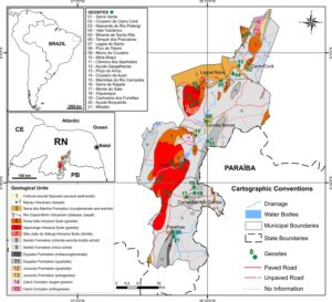
Figure 1. Geological and geosites location map.
Table 2. List of Seridó Aspiring Geopark geosites and its main interests.
ID | Geosite | Main Interests |
G01 | Serra Verde | Geomorphological, Paleontological, Archaeological |
G02 | Cruzeiro de Cerro Corá | Geomorphological |
G03 | Nascente do Rio Potengi | Geomorphological, Hydrological |
G04 | Vale Vulcânico | Petrological, Volcanic |
G05 | Mirante de Santa Rita | Geomorphological |
G06 | Tanque dos Poscianos | Geomorphological, Petrological |
G07 | Lagoa do Santo | Geomorphological, Hydrological, Paleontological, Archaeological |
G08 | Pico do Totoró | Geomorphological, Petrological |
G09 | Morro do Cruzeiro | Geomorphological, Mineralogical, Plutonic, Stratigraphic |
G10 | Mina Brejuí | Mineralogical, Petrological, Mining |
G11 | Cânions dos Apertados | Geomorphological. Hydrological, Stratigraphic, Archaeological |
G12 | Açude Gargalheiras | Geomorphological, Hydrological, Petrological |
G13 | Poço do Arroz | Geomorphological, Archaeological |
G14 | Cruzeiro de Acari | Mineralogical, Petrological |
G15 | Marmitas do Rio Carnaúbas | Geomorphological, Hydrological, Archaeological |
G16 | Serra da Rajada | Geomorphological, Petrological |
G17 | Monte do Galo | Geomorphological, Mineralogical |
G18 | Xiquexique | Geomorphological, Archaeological |
G19 | Cachoeira dos Fundões | Geomorphological, Hydrological, Archaeological |
G20 | Açude Boqueirão | Geomorphological, Hydrological, Mineralogical |
G21 | Mirador | Geomorphological, Archaeological |
Ecosystem Services
Several authors since the late 1970s have defined the Ecosystem Services (ES) and created classifications associated with the term. Over the past 40 years, discussions on ecosystem services have been ongoing and their application has expanded, especially after the United Nations (UN) realized the Millennium Ecosystem Assessment (MEA) in the early 2000s (McDonough et al. 2017).
It is common but not essential to abdicate development for the environment or the environment for development, but it is necessary to balance the account to ensure sustainability. Several studies have sought to show the relationship between human beings and nature, and propose actions to ensure that this relationship is stable and lasting for the entire ecosystem in a sustainable manner; examples are Balmford et al. (2002), Hopwood et al. (2005), and Raufflet et al. (2014). More intense scientific discussions on how to protect the elements of nature began in the second half of the twentieth century. Economists have pointed out that the most efficient way would be to determine a value for such resources. Westman (1977) then creates what he calls the value of nature, which is associated with a loss of monetary value owing to the degradation of an ecosystem or part of it. Alternatively, it would be associated with the amount needed to reverse environmental impacts. Ehrlich & Mooney (1983) were the first to use the term ecosystem services, which continues to this day. The definition of these services sought to demonstrate how a massive loss of species would affect the ecosystem and how environmental changes would affect the stability and resilience of the Earth’s systems (Mooney & Ehrlich 1997). Daily (1997) defined ecosystem services as the conditions and processes through which natural ecosystems, and the species that compose them, sustain and enhance human life.
By applying the Delphi method, Ruppert & Duncan (2017) conceptualized ecosystem services as a wide range of direct and indirect, monetary and non-monetary, benefits that humans obtain as a result of being involved within an active, native or modified ecosystem. The human activity that changes the structure of the ecosystem is the major contributor to changes in ESs. Including ESs in decision-making can provide incentives to preserve native ecosystems or restore ecosystem functioning. In all definitions, despite slight variations, the importance of the relationship between human beings and nature remains, in addition to the benefits, understood here as services, that this relationship provides for the human being.
Ecosystem Services and Geodiversity
Ecosystem services are a broadly consolidated category for biodiversity and conservation studies. The work of English Nature (2002) indicates that it is possible to apply nature's ecosystem services to geodiversity studies, as a way of describing nature's contribution to the quality of life on the planet and promoting a good relationship between geodiversity studies and those of biodiversity. Gray (2008), in turn, reports the importance of abiotic elements for ecosystems as a whole, as well as for life on the planet.
Gray (2011) recognizes geosystems services as “the goods and functions associated with geodiversity”, in parallel to the definitions of ecosystem services made years earlier via the Millennium Ecosystem Assessment (MEA). The author developed the concept and adapted the definition of MEA ecosystem services to geodiversity. The regulation, support, cultural, provisioning, and knowledge services were thereby defined. Brilha et al. (2018) point out that the ecosystem services approach is currently a fundamental key in decision-making involving sustainable development, especially in the definition of qualitative and quantitative values. This indicates a specific assessment system based on the contribution of geodiversity to establishing and maintaining environmental conditions. In this paper, the authors integrated the knowledge service, elucidated by Gray (2013), with the cultural service.
It is possible to integrate geodiversity studies with those of biodiversity, analyzing the natural diversity of the planet (Parks & Mulligan 2010; Anderson et al. 2015; Hjort et al. 2015; Silva 2018). Thus, several actions can be combined for the conservation of the environment. The specialized literature already recognizes geodiversity as the fundamental provider of ecosystem services, examples of this are Gordon & Barron (2013), Silva (2016), Rabelo et al. (2018), Garcia (2019), and Reverte (2019). Works that have this focus on the evaluation of abiotic nature should be encouraged so that there is more dialogue on this subject in environmental studies.
Material and Methods
In studies on abiotic nature, one of the most used methods for qualitative valuation is that of Gray (2004), which defines a system of six values (intrinsic, cultural, aesthetic, economic, functional and scientific) and 32 subvalues. Beginning with the MEA definition of ecosystem services, the author defined a system that fits in with the method already employed for biodiversity. Gray (2013) defined five ecosystem services of geodiversity with which 25 goods and processes are associated.
The same method was used in this work to analyze 21 geosites of the Seridó Aspiring Geopark. The aim was to elucidate the relationship between abiotic elements and local natural diversity and the communities in the region, providing a theoretical basis for geoconservation actions, and identifying the importance of geodiversity for all nature.
The work presented here was initiated by a literature review on the subject and a deepening of the methodology proposed by Gray (2013). Subsequently, field stages were carried out, from January 20th to 21st, 2018, April 3rd and 6th, 2018, from June 19th to 21st, 2018, September 12th to 15th 2019, and August 07th to 08th 2020. During these stages, all 21 geosites that make up the Seridó Aspiring Geopark were visited to assess the local relationships of geodiversity with all natural diversity and the anthropic communities of the region. Information was collected about the geology of the places. Local guides accompanied some of the field stages and provided more historical and archaeological information about the places visited.
From the field evaluations, the services, goods, and processes available at the geodiversity found at the geosites were listed. This was done to assess the importance of abiotic elements for both nature and local communities. For this process, the definitions of Gray (2013) were used, synthesized in Fig. 2, in addition to the following descriptions.
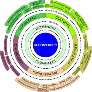
Figure 2. Simplified diagram of geodiversity ecosystem services as elucidated by Gray (2013). Modified from Silva (2016).
Intrinsic Value
This refers to the ethical belief that some things are of value simply because of what they are, and not for their use by humans. Washington (2018) provides two reasons for geodiversity to have an intrinsic value: for being the substratum of life and for being unique and susceptible to degradation and destruction. The author further stresses that having value does not mean that geodiversity should be untouchable; it simply means that it should be used with respect.
Regulating Services
Geodiversity regulation services are responsible for maintaining the balance and stability of processes and phenomena on the planet, thus controlling the natural dynamics. Associated with this service are: atmospheric and oceanic processes, terrestrial processes, flood control, and water quality.
Supporting Services
When geodiversity is used by natural beings, humans included, as a substrate for the development of their activities, as housing, or even for reproduction, it defines the so-called abiotic supporting service, to which the following assets and processes are associated: soil processes, habitat provision, platform, burial, and storage.
Provisioning Services
These are related to the physical environment making available material goods for use by human societies. It is usually associated with a monetary value, sometimes extremely high, which facilitates its identification. Seven types of goods and processes made available by geodiversity enable the determination of a provisioning service: food and beverage, nutrients and minerals for healthy growth, mineral fuels, construction materials, industrial and metallic minerals, and gems and fossils.
Cultural Services
These include the social or community meanings of some aspects of the physical environment, which have been common in human societies since prehistory, by its identification with the environment. Five categories of goods and processes are related to geodiversity: environmental quality; geotourism and leisure activities; cultural, historical, and spiritual meaning; artistic inspiration; and social development.
Knowledge Services
Knowledge services relate the physical environment to a research laboratory and stress on its importance as a source of information for science and education. The following goods and processes are related to it: earth history, research history, environmental monitoring, geoforensics, and education and employment.
Results
The definition of the qualitative value of geodiversity is based on the interpretation of the interaction of nature's abiotic elements with natural processes, biodiversity and the surrounding communities. It aims to demonstrate the importance of abiotic diversity for the establishment and conservation of environmental balance as well as the development of human societies. From the 25 goods and processes related to the five geodiversity ecosystem services defined in Gray (2013), it was possible to identify 20 applicable to the Seridó Aspiring Geopark.
From the regulating service, atmospheric processes were observed only in the Nascente do Rio Potengi Geosite, as it is an important place in a hydrological cycle as a source for an important river of the region. Terrestrial processes were identified through the action of weathering and erosion, responsible for modeling the local geomorphology to generate features such as canyons (Fig. 3), and geoforms such as Nose Stone, Whale Stone, Turtle Stone, and Cashew Stone. The equilibrium and quality conditions of the surface water and groundwater in the region are controlled by stormwater filtration through sediments and rock layers, which characterize a water quality asset.

Figure 3. The river erosion processes were responsible for modeling the canyons found in the Cânions dos Apertados Geosite, an example of a geodiversity regulating service. Photo: Matheus Lisboa.
The supporting service was observed through soil processes, by providing soil resources for the establishment and development of plant species as well as microorganisms, and habitat provision for local biodiversity (Fig. 4A). A platform for the use of geodiversity elements as a foundation and base for the construction of monuments and buildings was built, especially with religious functions, and burial and storage, as evidenced by the presence of burial chambers as well as the accumulation of water in some geosites.
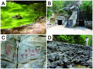
Figure 4. A) Frog found in pond on Serra Verde geosite, which evidences a regulating service (habitat provision). B) Entrance of Brejuí Mine geosite, that provides a provisioning service (industrial minerals). C) Rock painting on a quartzite in the Xiquexique geosite, an example of cultural service (historic meaning). D) Horizontal columnar disjunctions, an evidence of a Cenozoic volcanism that can be used for education, a knowledge service. Photos: Matheus Lisboa.
The provisioning service is recognized in the study area by the provision of water for human or animal consumption. The exploration of geodiversity elements for use as building materials, such as blocks for foundations, columns and/or walls, also represents a provisioning service or even as a finished element. The exploration of scheelite (CaWO4) in the Brejuí Mine Geosite (Fig. 4B) represents the provisioning of industrial and metallic minerals. Finally, the existence of Pleistocene megafauna fossils in the region is also associated with the provisioning service.
All assets and processes associated with the cultural service could be identified in the study area. Environmental quality was identified by the scenic beauty constituted by the geodiversity elements in the region, also used as an observatory for landscape observation. The practice of adventure-type leisure activities, such as hiking, climbing, and abseiling, also takes place in the area. Local geodiversity has a high cultural, historical, and spiritual significance, observed in the existence of legends and stories, religious movements, communities’ harmony with the environment, and use of rocks as a canvas for paintings and rock engravings that record the existence of ancient peoples in the region (Fig. 4C). It is also possible to identify cultural services through social development actions; by environmentally conscious visitation, observed from local communities' signs and conduct; by local geodiversity serving as a source of artistic inspiration; and through the production of poetry, music, paintings, or other expressions that portray the abiotic diversity of the region.
The knowledge service is linked to the scientific content presented at geosites. This content can be used for the promotion of education and employment, not only in the geosciences, but in various other areas. There are places in the study area that are connected to the Earth’s history (Fig. 4D) or the history of research because they have been used in various published scientific works, in addition to their significant use by geoscience professionals.
The only unidentified goods and processes in the area were flood control related to the regulating service, nutrients and minerals for healthy growth and mineral fuels, the provisioning service, and environmental monitoring and geoforensics, which are aspects of the knowledge service. This is explained, for example, because there is no extraction in the study area of mineral fuels such as oil, gas, and coal, which justifies the absence of this provisioning good. Similarly, there is no record of the consumption of minerals, soils, or any other abiotic element in disease prevention or medical treatment.
Regarding knowledge services, goods and processes were not identified in the Seridó Aspiring Geopark, these could not be identified because environmental conditions such as global warming, water pollution and others are not monitored in the region through local geodiversity elements. This monitoring may occur otherwise, but the use of abiotic elements for this purpose is not characterized here. Nor is there, within the limits of the study area, the use of soils or other elements of geodiversity in the search for and collection of evidence for solving crimes (geoforensics).
By defining the goods and processes (Table 3), the predominance of three services in the evaluation performed was observed: supporting, cultural and knowledge services. These are identified in all 21 geosites analyzed in the study area.
Table 3. Synthesis of geodiversity ecosystem services identified in the area of the Seridó Aspiring Geopark according to the geosites evaluated.
SERVICES Goods and processes | GEOSITES | ||||||||||||||||||||
01 | 02 | 03 | 04 | 05 | 06 | 07 | 08 | 09 | 10 | 11 | 12 | 13 | 14 | 15 | 16 | 17 | 18 | 19 | 20 | 21 | |
REGULATING |
| ||||||||||||||||||||
- Atmospheric and oceanic processes |
|
| X |
|
|
|
|
|
|
|
|
|
|
|
|
|
|
|
|
|
|
- Terrestrial processes | X |
|
|
|
|
| X | X |
|
| X |
| X |
| X | X |
|
|
|
|
|
- Flood regulation | NOT IDENTIFIED | ||||||||||||||||||||
- Water quality |
|
| X |
| X | X | X |
|
|
| X | X | X |
| X |
|
|
| X | X |
|
SUPPORTING |
| ||||||||||||||||||||
- Soil processes |
|
| X |
| X |
|
|
|
|
|
|
|
|
|
| X |
|
|
|
|
|
- Habitat | X |
|
|
|
|
| X | X |
|
| X |
|
|
| X |
|
| X |
|
| X |
- Plataform |
| X |
| X |
|
|
| X | X | X |
| X |
| X |
| X | X |
|
| X |
|
- Burial and storage | X |
| X |
|
| X | X | X |
|
|
| X | X |
| X |
|
|
|
| X | X |
PROVISIONING |
| ||||||||||||||||||||
- Food and drink | X |
| X |
|
| X | X | X |
|
|
| X | X |
| X |
|
|
| X | X |
|
- Nutrients and minerals for healthy growth | NOT IDENTIFIED | ||||||||||||||||||||
- Fuel | |||||||||||||||||||||
- Construction materials |
|
|
|
|
|
|
|
|
|
|
| X | X |
|
|
|
|
|
| X |
|
- Industrial minerals |
|
|
|
|
|
|
|
|
| X |
|
|
|
|
|
|
|
|
|
|
|
- Ornamental products |
|
|
|
|
|
|
|
|
|
|
|
|
|
|
|
|
| X |
| X |
|
- Fossils | X |
|
|
|
|
| X |
|
|
|
|
|
|
|
|
|
|
|
|
|
|
CULTURAL |
| ||||||||||||||||||||
- Environmental quality | X | X |
| X |
| X |
| X | X |
| X | X |
|
| X | X | X | X | X | X | X |
- Geotourism and leisure |
|
|
|
| X | X |
| X |
|
|
|
|
|
|
| X |
| X | X | X | X |
- Cultural, spiritual and historic meanings | X | X | X |
|
|
| X |
| X | X |
|
| X | X | X | X | X | X |
| X | X |
- Artistic inspiration |
|
|
|
|
|
|
| X | X |
| X | X |
|
|
| X | X | X |
|
| X |
- Social development | X |
| X |
| X |
|
|
|
|
| X |
|
|
|
|
|
| X |
|
|
|
KNOWLEDGE |
| ||||||||||||||||||||
- Earth history |
|
|
|
| X |
|
| X | X | X | X | X |
| X |
| X |
|
|
|
|
|
- History of research |
|
|
|
| X |
|
| X |
| X |
| X |
| X |
|
|
|
|
| X |
|
- Environmental monitoring | NOT IDENTIFIED | ||||||||||||||||||||
- Geoforensics | |||||||||||||||||||||
- Education and employment | X | X | X | X | X | X | X | X | X | X | X | X | X | X | X | X | X | X | X | X | X |
GEOSITES: 01 – Serra Verde; 02 – Cruzeiro de Cerro Corá; 03 – Nascente do Rio Potengi; 04 – Vale Vulcânico; 05 – Mirante Santa Rita; 06 – Tanque dos Poscianos; 07 – Lagoa do Santo; 08 – Pico do Totoró; 09 – Morro do Cruzeiro; 10 – Mina Brejuí; 11 – Cânions dos Apertados; 12 – Açude Gargalheiras; 13 – Poço do Arroz; 14 – Cruzeiro de Acari; 15 – Marmitas do Rio Carnaúba; 16 – Serra da Rajada; 17 – Monte do Galo; 18 – Xiquexique; 19 – Cachoeira dos Fundões; 20 – Açude Boqueirão; 21 – Mirador | |||||||||||||||||||||
Discussion
The identification of supporting services at all geosites shows the importance of abiotic elements for the establishment and development of biodiversity and human beings in the region. The cultural service reaffirms the relationship of local communities with the environment in which they live. The pride and recognition of people in the region with their origins, culture and environment is clear. This includes the physical environment, especially the landscapes that frame their daily life. The knowledge service, present in all places of geological interest, shows the relevant scientific content of the Seridó Aspiring Geopark. It is reflected in research work or education activities whose teaching tool is the element of local geodiversity. These two services are the most important in the foundation of a geopark. By definition, it must be an area that, in addition to having a remarkable geological heritage, which denotes a high scientific value, must be integrated with local communities, allowing for a sustainable development and people's recognition of the project and the environment in which they live, which defines the cultural service of geodiversity.
Of the 21 geosites considered for evaluation in this study, seven (Fig. 5) have all ecosystem services types associated with Gray’s (2013) classification. They are: Serra Verde, Lagoa do Santo, Pico do Totoró, Açude Gargalheiras, Poço do Arroz, Marmitas do Rio Carnaúba and Açude Boqueirão. Therefore, these geosites can be considered the most diverse in terms of geodiversity. The elements contained in them are examples of the main processes in which abiotic nature is involved in the context of ecosystems and in the availability of resources for humans.
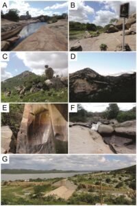
Figure 5. Main geosites from the Seridó Aspiring Geopark according to the evaluation carried on this work: A) Serra Verde. B) Lagoa do Santo. C) Pico do Totoró. D) Açude Gargalheiras. E) Poço do Arroz. F) Marmitas do Rio Carnaúbas. G) Açude Boqueirão. Photos: Matheus Lisboa.
In general, the geosites that, individually, have more associated goods and processes are Pico do Totoró (11), Açude Boqueirão (11), Açude Gargalheiras (10), Serra Verde (9), Serra da Rajada (9), Nascente do Rio Potengi (8), Lagoa do Santo (8), Cânions dos Apertados (8), Marmitas do Rio Carnaúba (8), and Xiquexique (8). However, the diversity of goods and processes is not always reflected in the diversity of ecosystem services types. For example, 9 goods and processes were associated with the Serra da Rajada Geosite, five of which are cultural service.
Ecosystem services explain the importance of geodiversity elements for the establishment and maintenance of environmental conditions. By identifying this relationship, they allow better management of natural resources and the development of sustainable economic activities, as stated by Gray (2013), Gordon & Barron (2013), and Hjort et al. (2015).
The results achieved with this work are in accordance with those of Pereira (2017) and Garcia (2019) that show the importance of geodiversity for ecosystems, specifically for the establishment of ecosystem services in the Terra de Cavaleiros UNESCO Geopark and the state of São Paulo, southeastern Brazil. It also follows what Boothroyd & McHenry (2019) claimed about the importance and real possibility of integrating geodiversity studies with biodiversity. Thus, the identification of services in the Seridó Aspiring Geopark provides relevant information for understanding the environment in which the project is embedded, enabling better planning of activities relating to the protection of abiotic elements of nature.
Conclusion
The concept of ecosystem services has made a significant contribution to environmental studies and has been widely used in biodiversity assessment and more recently applied to geodiversity. It is a fact that most services for which nature is responsible require the substratum or collaboration with abiotic elements. Thus, it can be said that geodiversity is fundamental in the delivery of nature's ecosystem services.
From the methodology employed in this work, it can be seen that the Seridó Aspiring Geopark area, in the Brazilian Northeast, has unique examples of geodiversity’s elements, which demonstrate the importance of abiotic elements for the environment. There is a strong relationship between local communities and the environment, which is represented, for example, by regional culture. By identifying ecosystem services at geosites, it was possible to demonstrate the importance of abiotic nature in the area.
Continued use of the concept of ecosystem services in the studies of geodiversity should be encouraged, especially for developing a dialogue with the biosciences to seek its integration in environmental studies, since such terminology is already used in biodiversity assessment. Thus, it is possible to scientifically represent to all society the importance of nature for ecosystems and for human beings, creating a basis for conservation actions.
Acknowledgment
The authors would like to thank Capes Capes – Coordenação de Aperfeiçoamento de Pessoal de Nível Superior – for the finantial support [grant number: 1696250]. Also, many thanks to the Geoconservation Research evaluators for their valuable contributions.
Conflict of Interest
The authors declare that there is no conflict of interest.